Inspired by the 500th anniversary of the birth of Mercator and on the occasion of the international conference in Sint-Niklaas, Mercator Revisited – Cartography in the Age of Discovery, Aquaterra wanted to digitally recreate the coloured version of the Mercator World Map of 1569 based on the Atlas of the World owned by the Maritime Museum Rotterdam.
Mercator is assumed to have dissected and reassembled at least three copies of his original wall map to create this atlas filled with coherent units (e.g. continents). It should therefore be possible to digitally recreate a coloured wall map from the pieces used in the atlas with an image of one of the three still existing wall maps as reference.
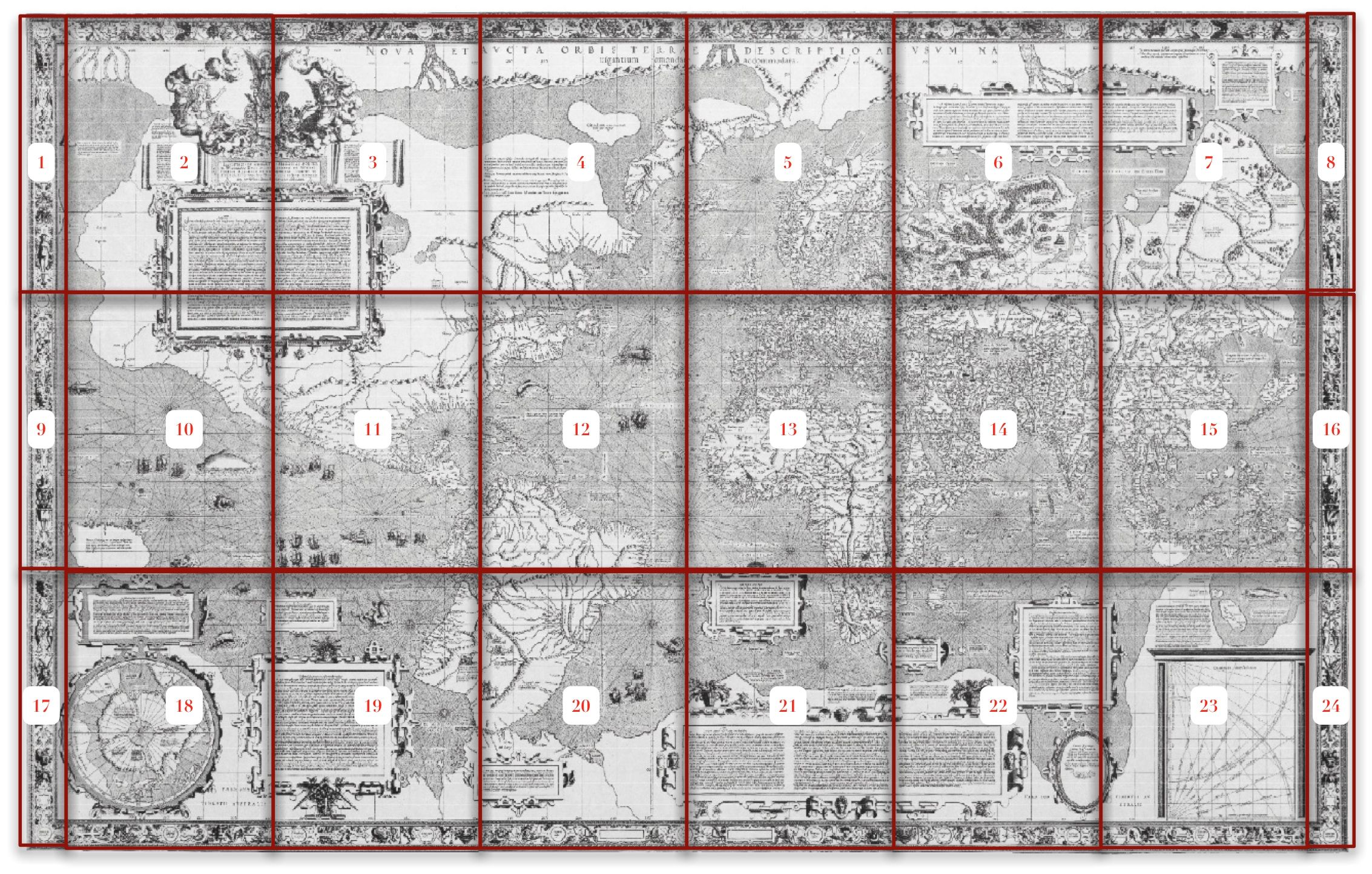
For the purpose of clarity, in this article, the atlas sheets will be referred to as ‘pages’ and the original wall map sheets as sheets.
In the facsimile the division of the atlas is extensively described and explained. Most importantly, whereas the original wall map was printed in 18 separate central sheets (or 24 sheets in total, with the marginal sheets), the atlas is made up out of 18 pages containing maps and texts derived from at least three wall maps. These pages have been made from cut-out pieces and ordered by subject (continents, oceans or groups of legends). This means that for a great part of the maps in the atlas an overlap with other pages was needed to be able to cover the different geographic entities. Only the last page (18 - southern part of the Pacific Ocean) doesn't seem to fit this logic.
The Paris map[1] is in poor condition and it only consists of the central 18 sheets so it doesn't have the borders and additional cartography on the left and right side of the map.
The Breslau map [2] was lost during WWII but was already in such a bad condition in 1891 that a facsimile was made.
The Basel map[3] however is considered the cleanest of the three extant wall maps so this would be the best reference image. It is made up of three separate rows each consisting of eight sheets (counting the left and right border as two sheets) rather than a single assembled map. On the 1992 reproduction by Wilhelm Kruecken on a reduced scale there was significant spacing between the three strips. To solve this, a scan at 400 dpi of the reproduction was made and the three strips where cut out of the image and reassembled to form a more suitable reference map.
Any visible significant difference or cutline on the image of the atlas page was then used to identify distinct pieces. For every piece a unique set of control points was created until an acceptable correspondence was reached between the entire set of imagery contained in the atlas and the reference map.
Because evidently in the facsimile all tangible differences in the pages were lost and several cutlines follow coloured edges, there will most likely be additional pieces to be found in the atlas. This would need a visual inspection of the original atlas in Rotterdam. Although it would have been easier to identify the pieces based on the original atlas rather than on the scanned images of a facsimile, for our purposes this was more than sufficient. It was never a goal to identify all the different pieces in the atlas but to create a coloured and assembled image of the wall map.
Although the pages were referenced on a single reference image the inherent geometrical differences between the images on two scans of two different historical documents are too irregular to resolve. This would result in an assembled image with notable discrepancies between adjacent or overlapping pieces.
Every referenced piece adjacent to or overlapping with another referenced piece was therefore given a new set of control points with regard to its neighbours. This way a more visually pleasing end result could be created.
In a final stage the order in which the pieces would have to be combined was determined. Because of the overlaps and colouring differences a master image was created with the least obtrusive transitions between the pieces. Nevertheless it might be interesting to create a second image which shows exactly the opposite.
Depending on whether you take into account the map area of the 18 central sheets or that of all 24 sheets, between 8 and 9 % of the original wall map coverage (all borders excluded) is lost in the atlas. The most significant losses are approximately 3 cm of the entire northern edge except for the title, the area around the cartouche with the map of the North Pole, the map area to the left and right of the dedication to Mercator's patron, the area around cartouches in the lower right corner of the wall map and a piece of cartography between pages 4 and 12.
A total of thirty five distinct pieces were identified based on a primarily visual analysis. Further detailed analysis (taking into account paper composition, aging, colouring, tangible cutlines, etc.) would probably result in a greater number. Even so, at the moment of writing this article no solution has been found to create the atlas (with the known pieces and overlapping areas) from three original wall maps. It seems that sheets from a minimum of four wall maps was needed to create the atlas.
Though the pages were created according to geographic entities, still between 30 % and 35 % of the cutlines correspond with the edges of an original wall map sheet. Most of the pages are made up out of the central 18 sheets. Only pages 16 and 17 require the additional left and right bordering sheets.
Oddly enough, there are colouring differences between adjacent/overlapping pages in the atlas. This might indicate that several differently coloured wall maps were used or that the colouring was done independently after the assembly of the pages.
Title was cut out in twelve pieces and glued to a page in five lines. The cartouche with the copyright notice was cut from the lower right corner of the wall map and glued to the same page. Some pieces of the title overlap with page 4. Six sheets from one wall map were needed to create this page.
This page contains the dedication to Mercator's patron (the Duke of Cleves) with an allegory depicting the good government by the duke and a poem in two pieces to express his gratitude to the duke. All the items on this page can be found in the upper left corner of the wall map and were cut out and glued to a page in a different layout. Some additional clouds were added to the top of the allegory. At the bottom extra grass and blue border added in manuscript help hide the fact that this allegory was attached to a cartouche like the one on page 3.
The two pieces of poem that originally belong to the left and right of the allegory were placed below the dedication/allegory. A corner of the paper scroll in the upper right of the left piece has been drawn to replace the clouds in the original. No cutlines were found in the allegory/dedication piece where the poem pieces originally were, so this might indicate that the allegory/dedication comes from a different state of print.
The first rule of the second piece of the poem has been changed from Iam quoque cum tali regitur moderamine civis to Iam quoque aú tanto regitur moderamine civis. Notice the comma at the end and the use of an abbreviation: aú (short for auro?). Because the editor just wanted to replace the words cum tali it was necessary to use an abbreviation to occupy the same space. This would indicate that this text in the atlas is of later date than the one in the known wall map versions (Paris, Breslau and Basel).
Four (2 x 2) sheets from two wall maps were needed to create this page.
This cartouche is found on the wall map below the dedication. On the left and lower side traces can be seen of erased waterways and erased text between the cartouche and the cutline. Additionally a certain amount of cartography and text around this cartouche is lost in the atlas. There is an empty overlap between the poem pieces on page 2. The piece on this page might be from the same state as the dedication/allegory on page 2. This piece also overlaps with page 8 in which the cartouche is empty. So again: two different states have been used.
Four sheets from one wall map were needed to create this page.
At the top of the page some pieces of paper are glued over the areas were the title was on the wall map. Because it can't be determined from the image in the facsimile if there is any text under the pieces it can't be entirely ruled out that this page and the pieces on page 1 are cut from the same wall map. The vigantium piece from page 1 however is even larger than the piece of paper that hides the same text on page 4.
A wedge has been cut out round the text (about French and Portuguese voyages in the sixteenth century to the northwest of America) on the left side and shifted 3 cm to the right so the entire text fitted on the page. No corrections have been made to the thus interrupted longitude lines and the coastline of North America, although some coloring has been added to the mountain tops underneath.
Four sheets from one wall map were needed to create this page.
The top and bottom edges of this page follow the sheet edges. Notice the full red coloring of the island in the lower left corner. There is an obvious difference in coloring of the islands Aruba, Curacao, Granada, etc. with the same islands on page 18. This would mean 2 already coloured pages have been cut up or the coloring happened after the assembling of the Atlas. Coloring differences (West-Africa coastline and islands) with page 11 and also between Caribbean island here and on page 8. Same conclusion as above.
Three sheets from one wall map were needed to create this page.
Notice the highlighted meridian on this page differs from the rest of the atlas: here the 340° meridian has been given red and white stripes and not the 350° as on the other pages. Latitudes have been added to the left of this meridian.
Four sheets from one wall map were needed to create this page.
The large cartouche about the Ganges (originally in the lower right corner) and the geography of south-east Asia has been cut out and some additional cartography has been drawn to hide this. The text Pars continentis australis has been added in manuscript, probably by Mercator himself, in the empty space. Based on the cutlines, page 7 and the cartouche on page 14 could come from the same wall map. Notice the empty cartouche where a text about The Niger and Nile rivers and their possible linkage should have been. This might indicate this page originates from a different state than page 11 where the text is present. Notice also the difference in color between the Insula de Gonçalo Alvares on page 7 and page 11: two different coloured sheets have been cut up, or else the coloring happened afterwards.
Four sheets from one wall map were needed to create this page.
This page is one of the two pages in the atlas that are wider and has been made out of two pieces each from opposite sides of the wall map. Texts between the two pieces don't match. The cartouche on the top of the page is empty. This might indicate this page originates from a different print state than page 3 where the text is present. The top and bottom edges of this page follow the sheet edges. Notice the full red coloring of the island in the lower left corner (see further, page 9). Notice the color difference in the islands Celebes, Ambon, etc. to those on page 13.
Three sheets from one wall map were needed to create this page.
The top edge of this page follows the sheet edges. The piece of the large cartouche about the Ganges and the geography of south-east Asia has been cut out and/or masked by a piece of paper. Based on the cutlines page 9 and the cartouche on page 14 could come from the same wall map. Notice the red border coloring of the islands at the top of the page. This differs from the full coloring on pages 5 and 8. On this page the top and bottom black border is much wider than on the other pages. The drawing of the sea monster on the right side of the page seems to continue in the black border.
Transfer of red coloring of the highlighted meridian on the right side of the page to the left side has happened due to folding. This is at least a very strong indication the coloring took place at the moment of assembling the Atlas, unless (very unlikely) only the meridian had to be coloured and the rest of the sheet already was).
Three sheets from one wall map were needed to create this page.
Coloring differences in the lower part of the page with the coloring on pages 5 and 11. The cartouche on the top of the page is empty. This might indicate this page originates from a different state than page 12 where the text is present.
Four sheets from one wall map were needed to create this page.
Coloring differences with pages 5 (West Africa) and 10. Text in the cartouche in the lower left corner is present. The text is missing on page 7. This might indicate this page originates from a different state of print than page 7. The cartouche on the right side of the page is found on the wall map below Africa. It has been cut out and moved to the right of this page where another cartouche used to be. Additional cartography was created in both locations to mask the cutting and pasting.
Four sheets from one wall map were needed to create this page.
This page is the second of the two pages in the atlas that are wider and has also been made out of two pieces from opposite sides of the wall map. Texts between the two pieces have been adjusted. The text to the right of the magnetic pole is masked by a piece of paper. El streto de Anian has been split into five lines and there is a difference between the capital A of Anian on the reference wall map and in the atlas. Also the text Arcticus has been added to form Arcticus Circulus instead of Circulus arcticus. The cartouche on the upper left side of the page is filled with text. This might indicate this page originates from a different state than page 10 where the cartouche is empty.
Four sheets from one wall map were needed to create this page.
Coloring differences on the left side with pages 10, 11 and 12. Coloring differences on the right side with pages 8 and 16. The top and bottom edges of this page follow the sheet edges.
Two sheets from one wall map were needed to create this page.
The cartouche about the Ganges and the geography of south-east Asia has been cut out from the bottom of the wall map and glued to a page. Based on the cutlines the cartouche on page 14 and either page 7 or 9 could come from the same wall map.
Three sheets from one wall map were needed to create this page.
The cartouche about the Organum Directorium has been cut out from the lower right of the wall map and glued to a page. Based on the cutlines the cartouche on page 15 and page 11 could come from the same wall map.
Two sheets from one wall map were needed to create this page.
This is one of two pages that contain imagery outside of the central 18 sheets of the wall map. Coloring differences on the top of the page with pages 8 and 13.
Three sheets from one wall map were needed to create this page.
The cartouche with the map of the North Pole has been cut out from the lower left of the wall map and glued to a page. This is the second of two pages that contain imagery outside of the central 18 sheets of the wall map.
Dependent on whether the top of the cartouche was cut from the adjacent sheet or additionally drawn three or two sheets from one wall map were needed to create this page.
This is the only page that overlaps entirely with the other pages in the atlas. The cartouche on the lower left side of the page is empty. This might indicate this page originates from a different state of print than page 9 where the text is present. As on page 9, a piece of the large cartouche on the original wall map about the Ganges and the geography of south-east Asia in the lower right corner has been cut out and/or masked by a piece of paper.
Four sheets from one wall map were needed to create this page.
Even though it was known in advance, from the documentation in the facsimile, that it wasn’t possible to recreate a complete wall map, the end result was more than visually satisfying. Interestingly enough, in reassembling the coloured Mercator 1569 World Map based on the Atlas of the World owned by the Maritiem Museum Rotterdam, we have indirectly learned some interesting things about the atlas and about the person who assumingly created it, namely Mercator. By sequentially analyzing the overlaps between the pages it became clear that to create the atlas one would need access to sheets of a minimum of four wall maps. The sheets even had to be from different states because a state with the allegory but without the poems must have existed and several cartouches appear with and without text in the atlas. The colour differences on the islands on pages 13, 16 and 18 suggest that at least three differently coloured versions were needed. Considering the cost of such things, this seems unthinkable. Hence, the (inconsistent) colouring must have taken place at the moment of assembling or (much) later. Further proof of this is page 9 of the atlas. Selective imagery from 20 (out of 24) different sheets was used: pages 16 and 17 contain pieces from the lower left and right border sheets. This means that the creator didn’t mind not using four sheets and even sacrificing up to 9 % of his original map coverage in the atlas. Whatever the motivation was behind the atlas (gift, prototype, creative use of leftovers, portable navigational tool, etc.), it remains an intriguing historical document.
by Stijn Tallir, st@aquaterra.be
[1]Kept in the Bibliothèque nationale, Paris, France
[2]Kept in the City Library of Wroclaw/Breslau, Poland
[3]Kept in the Universitätsbibliothek, Basel, Switzerland