The Brussels Map Circle

Home → Events (archives)

Events (archives)


Australia, Sydney
Organisation: Australian and New Zealand Map Society
Welcome to the ANZMapS Symposium! The symposium will precede a public lecture and workshop on 2 and 3 May 2024 organised by the University of Western Australia exploring the history and legacies of the Dutch East India Company (VOC) in the Indian Ocean World. Drawing on this theme, the symposium will explore the cartography of the Indian Ocean World reflecting its role in shaping human knowledge, culture and history from antiquity to present. Since ancient times this vast expanse of water has been an important area for trading and exchanging goods, people, culture, and knowledge.
The Indian Ocean is central to the world’s climate and biodiversity, its human trade and history. Mapping has been key to our understanding of the Indian Ocean and we will discuss many aspects of cartography. This event will be an excellent opportunity to connect with colleagues in the fields of cartography and surveying, and in related fields where mapping has played a key role.
Venue: State Library of New South Wales
Language: English
Entry fee: 135 AUD for non-members
URL: https://anzmaps.org/2024/03/08/2024-symposium-program/
Brussels Map Circle event


Brussels, Belgium
Organisation: The Brussels Map Circle
The MAPAF will be organised in close cooperation with the Maps and Plans Department of the Royal Library of Belgium who will show some very interesting items from their collection. On the other hand, every participant is invited to bring along a map, object, book or anything else of cartographic interest from his own collection to be presented and discussed by the present fellow members. Always an excellent occasion to learn more in a convivial atmosphere. If you have the intention to show an item, please let it know to Henri Godts at henri@arenbergauctions.com
Practical:
  • Public transport: Central Station and metro station Central Station / Centraal Station / Gare Centrale.
  • Public parking: Interparking Albertine-Square.
  • No entrance fee for Members.
  • Entrance fee for non-Members: EUR 5.00.
  • Fees are to be prepaid on our bank account before the MAPAF: IBAN BE52 0682 4754 2209 BIC: GKCCBEBB.
  • No cash payments during the event please.
Venue: Map Room / Cartes et Plans / Kaarten en Plannen, KBR (Royal Library of Belgium), Mont des Arts /Kunstberg, 1000 Brussels
E-mail: mapaf@bimcc.org
Time schedule: 14.00-16.00
Brussels Map Circle event


Brussels, Belgium
Organisation: The Brussels Map Circle
The Annual General Meeting (AGM) opens only for Brussels Map Circle active members. All members are encouraged to become Active Member by applying to the President at least three weeks before the meeting.
A personal invitation to this AGM with the agenda and the possibility of proxy vote will be sent out to all Active Members by separate mail at least two weeks before the meeting.
Venue: Map Room / Cartes et Plans / Kaarten en Plannen, KBR (Royal Library of Belgium), Mont des Arts /Kunstberg, 1000 Brussels
E-mail: president@bimcc.org
Time schedule: 10.00 - 12.00


Amsterdam, Netherlands
Organisation: Allard Pierson
Scientific research on maps from the period when the Netherlands actively participated in slave trade and colonial occupation sometimes provokes fierce public reactions: falsification of history and virtue propaganda! Woke! In this lecture, Margriet Hoogvliet explains why it is necessary to change our view of old maps. She does this in particular using texts and maps on Africa, America and Asia in Blaeus Atlas Maior (from 1662 onwards). We can no longer simply discuss Dutch cartography from the sixteenth century onwards as heritage that we as a society can be proud of, because there are too many dark sides that we cannot simply ignore. Recent scientific theorising on old maps and different perspectives will be discussed, providing surprising new insights. Registration here.
Venue: Singelkerk, Singel 452, Amsterdam
Language: Dutch
Time schedule: 14.15


Valenciennes, France
Organisation: Archives municipales et communautaires de Valenciennes
Jean-Louis Renteux, our member and former Vice-President, will give a lecture about the history of the mapping of Hainaut.
The first map of the county of Hainaut was drawn up in 1548 on the orders of Emperor Charles V. This was the golden age of cartography in the Spanish Netherlands. The lecture will set out the historical and scientific background to the production of the first maps of the region, and will look at the development of scientific and field cartography in Hainaut by Louis XIV's engineer-geographers. On this occasion, Jean-Louis Renteux will be presenting his collection of maps of Hainaut from Charles V to the French Revolution. This collection is now available online at the Valenciennes Archives website.
Venue: Médiathèque Simone-Veil - 4, rue Ferrand – 59300 Valenciennes (France)
Language: French
Time schedule: 18.00


Online, US
Organisation: California map society

Program

(The hours that follow are Pacific Time)
  • 9:15 - Informal Social Time
  • 9:30 - Welcome, President Ron Gibbs and Vice President Courtney Spikes
  • 9:35 - Evan Thornberry, Evan is the new Head & Curator of the David Rumsey Map Center at Stanford University. CMS warmly welcomes Evan who will provide an update on the Center, his vision moving forward, as well as news of upcoming events and exhibitions, along with a short Q&A
  • 10:00 - Robert Headland, The Non-Existent Islands of the Southern Ocean
  • 10:50 - Break
  • 11:00 - Suzanne Knecht, Night Watch: Memoirs of a Circumnavigation
  • 11:40 - Chet van Duzer, Imagined Territories around the South Pole: Exploring the Ring Continent on Early Globes and Maps
  • 12:25 - Announcements & Formal Closing of Conference

Registration here
Time schedule: 18:15 (Brussels)
URL: https://californiamapsociety.org/event-5554547
Brussels Map Circle event


's-Hertogenbosch, Netherlands
Organisation: Brussels Maps Circle
Change of date! The excursion will take place on 2 March
For its next Excursion, our Circle proposes to go to 's-Hertogenbosch to visit the Mapping Modernity exhibition at Design Museum Den Bosch.
Mapping Modernity is an exhibition that tells the story of our world in 250 maps. The history of modernity is one of control: over nature, populations and trade flows. Human beings placed themselves at the centre of the universe and used maps in an attempt to dominate a complex, elusive reality. Every map offers a glimpse into the mindset of those who commissioned it and the ways in which they sought to mould the world to suit them.
Mapping Modernity is the crowning achievement of the passionate collectors John Steegh and Harrie Teunissen, our member. Over the past 40 years, they have collected over 19,000 maps and 2,500 atlases between them. Every inch of space in their home in Dordrecht is covered with maps. In 2021, they donated their collection to Leiden University. For this exhibition, they worked with Design Museum Den Bosch to select 250 maps that tell the story of our modern world. A world in which human beings placed themselves at the centre and believed that they could assert their control over everything.
Harrie Teunissen will guide us through the exhibition. After the visit, opportunity to eat at the museum brasserie (to be confirmed).
Registration
If you wish to register please email to Marie-Anne Dage, Brussels Map Circle Secretary, marie.anne.dage@gmail.com.
Participation fee
EUR 13.50. Fees are to be prepaid on our bank account before the excursion date: IBAN BE52 0682 4754 2209 | BIC: GKCCBEBB
For practical details (communications, parking), see the exhibition web site.
Time schedule: 11.15
Entry fee: EUR 13.50


Online, USA
Organisation: Geography and Map collections at the Library of Congress
Reference librarians Amelia Raines and Julie Stoner will present an introduction to the Geography and Map collections at the Library of Congress. This general orientation session will highlight a wide range of cartographic formats and subject matter. The focus of the session will be on maps and online resources available to all patrons any time or place in the world. Topics covered will also include search tips and tricks, research and collection guides, ways to engage with the collections online, and how to prepare for a future trip to the reading room. After the presentation, staff look forward to answering additional questions from attendees.
Register here
Venue: Online (Zoom)
Language: English
Time schedule: 21.00 (Brussels)


Hong-Kong, China
Organisation: École française d’Extrême-Orient (EFEO), Institute of Chinese Studies, CUHK and Division of Humanities, HKUST
The symposium will bring together scholars from across the globe, to reflect on the state of the field with maps of East Asia produced between 1300 to 1800 drawn by Chinese, Korean and European mapmakers, focusing on the circulation of cartographic knowledge both within East Asia and from East Asia to Europe.
  • 6 December: Public Talks
  • 7 December: Workshop
  • 8 December: Public Talks
For enquiry, please contact University Archives & Special Collections at lbarsc@ust.hk.
Venue: LG4, Multi-Function Room, HKUST Library, Hong Kong
E-mail: lbarsc@ust.hk
URL: https://library.hkust.edu.hk/events/conferences/2023mapsympo[...]
Brussels Map Circle event


Brussels, Belgium
Organisation: The Brussels Map Circle
Final programme
  • 09.30 - Registration
  • 09.45 - Welcome address and Maps by Filippo Pigafetta by Wouter Bracke
  • 10.15 - Stanley’s maps of the Congo Basin by Mathilde Leduc
  • 10.45 - Dragutin Lerman, Croatian cartographer in the service of Henry Morton Stanley by Mirela Altic
  • 11.15 - Break
  • 11.30 - Maps before and after the Berlin Conference by Rick Smit
  • 12.00 - Capital and exploration: the Institut national de Géographie and the expedition of Josef Chavanne to Congo (1884) by Colin Dupont
  • 12.30 - Albert Paulis. From Bahr el Ghazal to Belgian Congo in maps by Marc Dassier
  • 13.00 - Closing remarks

Accompanying persons and non-Members are invited to pay EUR 20.00 on our bank account IBAN BE52 0682 4754 2209 | BIC: GKCCBEBB and to mention in the bank transfer 'Conference 2023' and the name of the person.
Registration If you would like to join this event please advice our Secretary Marie-Anne Dage.
Venue: Panorama Room, KBR (Royal Library of Belgium), Mont des Arts /Kunstberg, 1000 Brussels
Language: English
Contact: Marie-Anne Dage
E-mail: marie.anne.dage@gmail.com
Time schedule: 09.30 - 13.30
Entry fee: Free for Members. Accompanying persons and non-Members are invited to pay EUR 20.00 on our bank account IBAN BE52 0682 4754 2209 | BIC: GKCCBEBB and to mention in the bank transfer 'Conference 2023' and the name of the person.


Paris, France
Organisation: Commission Histoire du Comité Français de Cartographie
Par-delà les études classiques sur la place spécifique de la cartographie dans l’histoire des savoirs scientifiques, et les analyses répétées sur les engagements de la cartographie (et des cartographes) dans diverses opérations politiques, il est nécessaire d’envisager les relations de la cartographie avec les arts et les artistes ainsi que ses formes d’implication dans les cultures visuelles des sociétés modernes et contemporaines. Les recherches sur ce sujet sont déjà nombreuses, et fructueuses, et ont permis d’établir de façon décisive les multiples niveaux et formes d’interaction entre les mondes de la cartographie et les mondes de l’art.
Venue: Institut national d'histoire de l'art
URL: https://cartogallica.hypotheses.org/2744


Ostend, Belgium
Organisation: The Royal Belgian Marine Society and the Flanders Marine Institute
Programme
  • Donderdag 23 November 2023
    • 9:15 - Welkom: Jan Mees (VLIZ) & Eduard Somers (Koninklijke Belgische Marine Academie), Carl Decaluwé (Gouverneur West-Vlaanderen), Torsten Feys (VLIZ), Frederik Dhondt (Vrije Universiteit Brussel), Michael-W. Serruys (Koninklijke Belgische Marine Academie) & Stan Pannier (VLIZ)
    • 10:00 - Key Note 1: Small companies in a global perspective - Cátia Antunes (Leiden)
    • 11:15 - Pauze
    • 11:45 - Sessie 1 - The Ostend Company and its European merchants and investors
      • France and the Ostend Company - Pierrick Pourchasse (Brest)
      • The Lisbon link: Uncovering the Portuguese connection of the Ostend Company (1714-1730) - Gijs Dreijer (Leiden), Susana Münch Miranda (Lissabon) & João Paulo Salvado (Évora)
      • The Danish Ostend legacy: Supercargo Pieter Van Hurk in Copenhagen - Benjamin Asmussen (Kopenhagen)
    • 13:15 - Lunch
    • 14:30 - Sessie 2 - The Ostend Company’s European market: Shipping and smuggling
      • A Cantonese fairy tale. The Ostend tea trade and smuggle (1718-1756) - Jan Parmentier (Antwerpen)
      • The Ostend Company and the Sound Toll Registers, Dutch and Frisian skippers in Ostend - Jelle Jan Koopmans (Groningen)
      • Lighter and brighter: Indian cottons in Brussels in the first half of the eighteenth century - Veronika Hyden-Hanscho (Klagenfurt)
    • 16:00 - Pauze
    • 16:30 - Sessie 3 - The Ostend Company’s homeport(s) in the Austrian Netherlands
      • The Ostend Company and the Port and City of Ostend - Michael-W. Serruys (Brussel)
      • A rivalry of maritime aspirations between Bruges and Ostend (1715-1730) - Erik Muls (Leuven)
  • Vrijdag 24 November 2023
    • 9:00 - Key Note 2: Merchants or soldiers? The Ostend Company: local actions, maritime power and military conflicts in China and Bengal - Wim De Winter (Leuven)
    • 10:15 - Pauze
    • 10:45 - Sessie 4 – All on board to Asia
      • Commensality on board the Ostend Company’s East Indiamen - Dennis De Vriese (Brussel)
      • ‘Le pavillon impérial y est respecté’: on the context of the establishment and functioning of the Ostend settlement of Coblon on the Coromandel coast of India - Karel Stanĕk (Praag) & Michal Wanner (Praag)
      • The aftermath of Banquibazar: Dutch takeover, English mansion and Bengal police academy (1745-2020) - John Everaert (Gent)
      • Maritime comradeship and artistic taste. Eighteenth century clay portrait figures of the officers from Ostend and Danish East India Companies - Yi-Chieh ‘Mireille’ Shih (Leiden)
    • 12:15 - Lunch
    • 13:30 - Sessie 5 - The Ostend Company and European diplomacy
      • David and Goliath? Reassessing colonial competition and the struggle for global empire between the Dutch republic and the Habsburg Monarchy in the case of the Ostend Company - Jonathan Singerton (Amsterdam)
      • Law and interest: The politico-legal battle on the Ostend Company and ‘la vie du droit’ (1725-1730) - Frederik Dhondt (Brussel)
      • ‘The Emperor himself […] permitted the ships to go to the Indies’: Charles VI and the end of the Ostend Company - Charlotte Backerra (Göttingen)
    • 15:00 - Pauze
    • 15:30 - Sessie 6 - The Ostend Company and new societal ideas
      • The Ostend Company: Law of the Sea debates in the Age of mercantilism - Stefano Cattelan (Brussel)
      • ‘What if everyone would do it freely?’ The Ostend Company and the invention of modern business practices in eighteenth century St. Petersburg, Russia - Alexei Kraikovski (Genua)
    • 16:30 - Conclusie
Venue: VLIZ – InnovOcean Campus; Jacobsenstraat 1, 8400 Oostende
Language: English
Entry fee: EUR 30.00 / day
URL: https://oostendsecompagnie.wordpress.com/wetenschappelijk-co[...]


Ostend, Belgium
An evening of lectures and debates in Dutch open to the general public.
Programme
  • 19:00 - Welcome
    • Moderator: Wim De Winter (KU Leuven)
    • Bart Tommelein (Mayor of Ostend)
  • 19:15 - Oostendse Compagnie in globaal perspectief - Jan Parmentier (MAS)
  • 19:35 - Oostendse Companie in lokaal perspectief - Michael-W. Serruys (KBMA & VUB)
  • 19:55 Land en Zeeman - Giedo Vanhoecke and André Libin (Choir ‘Ier en gunter’) will be singing the only known Flemish eighteenth-century song about the East-India trade. Accompanied on guitar by Patrick Gyselen.
  • 20:05 - Oostendse Compagnie vandaag in fictieliteratuur - A conversation with authors Doris Klausing (De smaak van thee published in October 2023) and Katrien Van Hecke (Oostende is niet ver meer published in 2022)
  • 20:35 - Find out more about the Ostend Company
    • Book launch De Bibliografie van Oostende en de Middenkust (Fons Verheyde, VLIZ)
    • Book launch Reisjournaal van Michel de Febure (Jan Parmentier & Kristin Van Damme)
    • Exhibition ‘300 Years Ostend Company’ in the City Museum of Ostend (Nadia Stubbe, Heemkring De Plate)
    • Guided tours ‘Ostend and the Ostend Company’ (Dirk Beirens, Circle of city guides ‘Lange Nelle’)
  • 21:00 - Reception
    • Book sale about the Ostend Company
  • 22:00 - End
Venue: VLIZ – InnovOcean Campus; Jacobsenstraat 1, 8400 Ostend
URL: https://oostendsecompagnie.wordpress.com/public-lectures/


Online, UK
Organisation: Bodleian Libraries
Map Readings – Copyright and cartography: history, law and the circulation of geographical knowledge – Isabella Alexander (University of Technology, Sydney) in conversation with Elizabeth Baigent (School of Geography and the Environment, University of Oxford).
More information and registration here.
Venue: Online (Zoom)
URL: https://visit.bodleian.ox.ac.uk/tosca
Brussels Map Circle event


Brussels, Belgium
Organisation: The Brussels Map Circle
In Encounters in the New World: Jesuit Cartography of Americas, published by University of Chicago Press in 2022, Mirela Altic analyses maps produced by the Jesuits during their missionary work in the possessions of the Spanish, Portuguese, and French Crowns in both North and South Americas. She traces the Jesuit contribution to mapping and mapmaking from their arrival in the New World into the post-suppression period, placing it in the context of their worldwide undertakings in the fields of science and art. Altic’s analysis shows the incorporation of indigenous knowledge into the Jesuit maps, effectively making them an expression of cross-cultural communication—even as they were tools of colonial expansion. This ambiguity reflects the complex relationship between missions, knowledge, and empire. Presenting Jesuit maps as far more than just a physical survey of unknown space, the author argues that Jesuit mapping was in fact the most important link enabling an exchange of ideas and cultural concepts between the Old World and the New. Based on a comparative study of a large number of maps, the book enables an understanding of the process of Jesuit mapmaking within the context of worldwide cooperation, producing a fundamental document of this new area of study. In 2023 the book is awarded by the American Association of Geographers.
For more visit: https://press.uchicago.edu/ucp/books/book/chicago/E/bo95833620.html
Practical:
  • Please register: Marie-Anne Dage, Brussels Map Circle Secretary, marie.anne.dage@gmail.com.
  • No entrance fee for Members and KBR's staff.
  • Entrance fee for non-Members: EUR 5.00.
  • Fees are to be prepaid on our bank account before the lecture: IBAN BE52 0682 4754 2209 BIC GKCCBEBB.
  • No cash payments during the event please.
Venue: Map Room of KBR (Royal Library of Belgium)
Language: English
Contact: Marie-Anne Dage
E-mail: marie.anne.dage@gmail.com
Time schedule: 17.00


Paris, FR
22e Salon de la Carte Géographique Ancienne, du Globe & de l'Instrument Scientifique.
Venue: Hotel Ambassador, 16 bvd Haussmann 75009 Paris
Time schedule: 11.00-18.00
URL: http://www.map-fair.com/


Berlin, Germany
Organisation: The International Coronelli-Society for the Study of Globes and the Map Department of the Staatsbibliothek zu Berlin
In Berlin, the production of globes only began in the late eighteenth century, but developed into a very successful international production in the nineteenth century. The publishing houses of Dietrich Reimer, Ernst Schotte, Julius Heymann and - for the twentieth century - Columbus are particularly worthy of mention. This lively, but perhaps still somewhat under-researched publishing activity and the reopening of the Staatsbibliothek building Unter den Linden in 2021 are the reason to invite researchers of globe studies and all those interested to Berlin again after 25 years. The conference will take place in the Humboldt Hall of the Staatsbibliothek (Unter den Linden 8).
Two years ago, the Map Department was reunited in this building for the first time since the Second World War. The Map Department sees itself as one of the most active collections of cartographic works in Germany. While hardly any globes were included in the collection until the Second World War, it expanded thereafter to include significant objects (for example, the Sanuto brothers’ globe from the 1570s). Particularly in recent years, the focus of the collection has been on the Berlin production. Currently, the collection comprises about 280 globes produced up to the end of the Second World War. The Schnermann Collection, which comprises over 200 everyday objects of the twentieth century in the form of globes, also has a globe-relevant, if slightly curious, yet cultural-historical significance.
Venue: Humboldt Hall of the Staatsbibliothek (Unter den Linden 8), Berlin
Language: German and English
E-mail: vincenzo@coronelli.org
URL: https://coronellidotorg.wpcomstaging.com/symposien/


Online (Oxford), UK
Organisation: Bodleian Libraries
Bringing TOSCA’s 30th year to a close, this interdisciplinary conference explores how art affects cartography’s processes, products, and personnel. Ranging broadly over types of map, areas of the world, and time periods, the conference considers how the visual qualities of maps attract and entice, but also deceive and obfuscate; how artists have attended to maps in their practice; how aesthetic choices made by cartographers influence the message their maps convey – explicitly or implicitly; and what constitutes an artistically successful map/
More information and registration here.
Venue: Online (Zoom)
URL: https://visit.bodleian.ox.ac.uk/tosca-conference


Minneapolis, USA
Organisation: Society for History of Discoveries
The James Ford Bell Library, with its extensive collection of rare books, maps, manuscripts, and archival collections, documenting the history and impact of trade and cultural exchange before the nineteenth century, offers an ideal venue to host the 2023 Society for History of Discoveries conference. This year’s conference locale aligns with the global breadth of the Society’s mission by supporting research into expeditions, biographies, cartography, cultural interaction, technologies of travel, and myriad other aspects of geographic discovery. With its expansive resources, the Bell Library, and other University of Minnesota library collections, offers members of the Society and presenters an ideal opportunity to conduct research prior to and after the conference. The rich and fascinating collections embolden the inspiration for our conference.
Venue: James Ford Bell Library, University of Minnesota
URL: https://discoveryhistory.org/event-5153853


Stanford and online, USA
Organisation: California Map Society
Join the California Map Society for their August 19, 2023 conference, which will take place at the David Rumsey Map Center and online. You can register for the event here.
Speaker topics and speakers at the conference include:
  • Update on Rumsey Map Center projects, David Rumsey
  • Visualizing Place Exhibit at UC Berkeley, Jose Adrian Barragan-Alvarez
  • Apple Maps & Indigenous Boundaries, Brad Harried & James Irwin
  • Maps & Power, Chet Van Duzer
  • Collaborative Map Exploration with Pixeum, Tom Paper & Ron Gibbs
  • 17th-20th Century Dutch Canal Engineering Maps, Brynn Kramer
  • SFO Museum and Wayfinding App, Aaron Cope
  • Segmented Cities: Inter-group Conflict & Coexistence, Arjun Maheshwari
  • The San Francisco Scale Model, Gray Brechin
  • Open Historical Map, Jeff Meter & Minh Nguyen
Venue: David Rumsey Map Center and online
Language: English
Time schedule: 19:30 CET


Berlin, Germany
Organisation: Max Planck Institute for the History of Science (MPIWG)
A two-day Workshop (10-11 July 2023) for early career professionals (scholars, curators, archivists, and librarians) working in the history of cartography, will precede the Symposium. Hands-on activities led by four experts in the field may include work with the MPIWG’s collection of Chinese maps and discussions on developing digital humanities projects, as well as sessions focusing on the themes of color in map scholarship.
The Symposium (12 July 2023 keynote; 13-14 July 2023 sessions), focusing on Intersections in Map History, particularly welcomes proposals that connect to two themes that benefit from the research context and facilities of the MPIWG: “materiality” and cross-cultural research. The first theme calls attention to the importance of material attributes of maps, such as constraints that may be overlooked as scholars work increasingly with digitized sources. The second encourages dialogue and exchange between scholars working with comparable questions, sources or methodologies across different geographic spaces and contexts.
URL: https://ishmap.wordpress.com/ishmap-2023-berlin-symposium-an[...]
Brussels Map Circle event


Brussels, Belgium
Organisation: The Brussels Map Circle
Many old maps are as much works of art as tools for getting from one place to another, and one of the most engaging artistic embellishments of these maps are the decorative frames called cartouches, which often surround the map’s title and other details. Cartouches were an important cartographic design element from the fifteenth to the nineteenth century, and continue to be used on twenty-first century maps. Although they are one of the most visually engaging elements on maps, and despite the fact that it is often through the decoration of the cartouche that the cartographer speaks most directly to the viewer, revealing his or her interests or prejudices, there is no detailed study of them, no discussion of their earliest history or development, and no attempt to interpret the symbolism of a large number of them together. In this talk Chet Van Duzer will discuss the early history and development of cartouches, examine some of their sources, and explain their symbolism of several remarkable cartouches in detail.
Lecture by Chet Van Duzer (University of Rochester, USA)
Practical:
  • Please register: Marie-Anne Dage, Brussels Map Circle Secretary, marie.anne.dage@gmail.com.
  • No entrance fee for Members.
  • Entrance fee for non-Members: EUR 5.00.
  • Fees are to be prepaid on our bank account before the lecture: IBAN BE52 0682 4754 2209 BIC GKCCBEBB.
  • No cash payments during the event please.
Venue: Map Room of KBR (Royal Library of Belgium)
Language: English
Contact: Marie-Anne Dage
E-mail: marie.anne.dage@gmail.com
Time schedule: 15.00


London, UK
Organisation: Emily Mann (Bartlett School of Architecture) & Stephen Whiteman (The Courtauld)
Despite the attentions of cultural historians since the 1980s, maps still tend to escape close and critical study as fundamentally visual and material forms of communication, with histories of cartography remaining predominantly disconnected from these dimensions of the subject matter. This two-day symposium addresses this interdisciplinary challenge from a diverse range of perspectives that foreground such questions as: how do maps operate as representations, and how do culturally situated understandings of space shape how they are created, seen and read? How does the study of maps within specific historical or cultural contexts connect to broader issues in visual/material history? In what ways are coloniality and/or indigeneity made visible/material in maps? How can art-historical approaches inform other disciplinary analyses and uses of maps? Invited speakers will offer new perspectives through studies of cartographic objects from around the world, from early modern India, Iran, and China to the Atlantic world and contemporary South Africa.
Free, but registration needed
Venue: The Courtauld Institute of Art, Vernon Square, London WC1X 9EW
Language: English
URL: https://courtauld.ac.uk/whats-on/the-art-and-architecture-of[...]


London, UK
The largest Antique Map Fair in Europe, established 1980.
We exhibit at the historic London venue of the Royal Geographical Society (RGS). This event brings together around 40 of the leading national and international antiquarian map dealers as well as hundreds of visiting dealers, collectors, curators and map aficionados from all parts of the world. A very large selection of Original Antique Maps will be available for sale, ranging in age from the 15th C. to the 20th C., covering all parts of the world and priced to suit all pockets.
Venue: Royal Geographical Society
Entry fee: Free
URL: https://www.londonmapfairs.com/index.php


Kyoto and Online, Japan
Over the past 30 years, historians have reconceptualized the history of political space. We now recognize that discrete, exacting borders are largely a creation of the nineteenth and twentieth centuries, not a timeless or natural phenomenon. Our historical maps, however, do not reflect this new understanding, and draw all borders as clear, exact lines. In Japan’s kuniezu, for example, long stretches of provincial borders are described as undetermined. How can we accurately map vague borders? Relying on quantitative methods, this paper engages with that question as both a conceptual and a practical problem for digital mapping.
Speaker: Mark Ravina (University of Texas at Austin)
Discussants:
  • Richard Pegg (MacLean Collection)
  • D. Max Moerman (Columbia University)
  • Mario Cams (University of Oslo)
  • Elke Papelitzky (KU Leuven)
For online attendance, registration before 7 June through these form.
Venue: Seminar Room 1, International Research Center for Japanese Studies
Language: English
E-mail: kenkyo@nichibun.ac.jp
Time schedule: 8:00-10:00 CET
URL: https://www.nichibun.ac.jp/en/research/lectures/2023/06/09/


Online (Miami), USA
Organisation: University of Miami Special Collections
Featuring Kate Hunter, Senior Specialist, Daniel Crouch Rare Books in conversation with Arthur Dunkelman, Curator, Jay I. Kislak Collection
Hunter will share stories about three maps. The first is a map of Western Australia, where she grew up. The second is a Dutch East India Company [VOC] 18th-century chart of the Indian Ocean on vellum that helped the company establish a trade route that netted a fortune. Lastly, she will look at a silver punch bowl whose upside-down surface includes an engraved map that is an early rendering of Captain James Cook's first voyage (1769–1770).
Register here to attend online.
Language: English
Time schedule: 19:30 CET


Online (Miami), USA
Organisation: University of Miami Special Collections
This talk incorporates the disciplines of geography, history, anthropology, and the history of science to explore the intersection of map making and Indigeneity through ancestral, colonial, anti-colonial, and de-colonial lenses.
"More Indigenous territory has been claimed by maps than by guns." — Bernard Nietschmann, 1995
Whether true or not, this statement underlines the importance of understanding how cartographic practices and performances form a part of the historical and contemporary Indigenous experience. Inquiry will focus on how maps are used as tools to claim power, territory, sovereignty, and identity, and how they are leveraged for conservation and natural resource management on Indigenous territory.
The experience from a recently taught course at the University of Miami will serve as a guide for this conversation. The geographic scope will be global with an emphasis on the Americas.
Featuring Timothy Norris, Data Scientist, University Libraries in conversation with Arthur Dunkelman Curator, Jay I. Kislak Collection, University Libraries
Click here to sign up.
Venue: Online (Zoom)
Language: English
Time schedule: 19.00-20.00 CEST
Entry fee: Free
URL: https://www.eventbrite.com/e/indigenous-cartography-and-cart[...]


Brussels, Belgium
Organisation: Belgian Royal Academy for Overseas Sciences and ICA Commission on the History of Cartography
The 21st century map image of continents beyond Europe is still decisively shaped by inherited aesthetics and content dating back to the turn from explorative to imperialist cartography. The symposium welcomes contributions (papers and posters) to analyse aspects of the imperialist Global North hegemony by investigating topographic mapping, hydrographic charting, and thematic mapping in personal, institutional, and regional case studies. The regional scope of the conference are overseas continents and seascapes within the time frame from about the Napoleonic wars to the European de-colonization in the mid-twentieth century (1940s to 1960s).
The symposium will be held in English only and organized as a hybrid event both face-to-face at the Palace of the Academies in Brussels and via Livestream.
Venue: Rue Ducale / Hertogstraat 1, Brussels
URL: https://history.icaci.org/brussels-2023/


Lisbon, Portugal
Organisation: The Interuniversity Centre for the History of Science and Technology (CIUHCT)
This meeting aims to further the discussion opened in two previous workshops held in Lisbon in 2016 and 2018, and attended by leading experts on the History of Cartography.
Since the preceding workshops, considerable progress has been made on critical questions pertaining to the origins of European nautical cartography. The theme of this third workshop has been broadened to encompass a greater chronological and topical scope.
As in the previous editions, the workshop focuses on key issues surrounding the genesis and evolution of the medieval portolan chart. In addition, the meeting will emphasize new methods for the study of old nautical charts in general, including cartometric techniques of geometrical analysis and material examination.
This will also be the opportunity for sharing some results of the Medea-Chart Project, which officially ends in May 2023. ​
Venue: Instituto Hidrográfico, Lisbon
URL: https://www.portmeeting.org/


(online) London, UK
Organisation: The Warburg Institute
A lecture by Dr Leonardo Ariel Carrió Cataldi (CNRS Researcher, LARHRA, Lyon).
Lectures in the history of cartography convened by Catherine Delano-Smith (Institute of Historical Research), Peter Barber (formerly Map Library, British Library), Alessandro Scafi (Warburg Institute) and Philip Jagessar (King’s College London). Meetings are normally held on selected Thursdays at the Warburg Institute at 17.00 (admission free). Meetings are followed by refreshment. All are welcome. Enquiries: c.delano-smith@qmul.ac.uk.
Time schedule: 17.00
Entry fee: Admission fee. Please register.
URL: http://www.maphistory.info/warburgprog.html
Brussels Map Circle event


Amsterdam, The Netherlands
Organisation: The Brussels Map Circle
Your cartographic circle proposes to go to Amsterdam on Saturday 13 May 2023 to see the Open kaart – van atlas tot streetmap exhibition at the Allard Pierson museum.
It will show seven centuries of cartography in Nederland and cast a glance into the future.
The exhibition starts in Amsterdam, where cartography took off in the seventeenth century, and zooms out through Nederland and Europe to the world with special attention to Indonesia, Surinam and the Antilles.
Old and more recent maps will testify to colonial relations and their interpretations, geographical developments, the Netherlands’dealings with water and changing borders. A presentation is dedicated to the future of cartography in collaboration with the Amsterdam-based technology company TomTom.
All the maps, including works by Blaeu, Ortelius, Ptolemaeus and Bos, belong to the cartography collection of the Allard Pierson, one of the most important in Europe.
The Brussels Map Circle will offer the visit to members.
If you wish to register for this visit on Saturday 13 May 2023 in Amsterdam please let it know before Wednesday 15 March 2023 (The deadline for the registration has been extended!) to Marie-Anne Dage, Brussels Map Circle Secretary, marie.anne.dage@gmail.com.
For practical details (communications, parking), see the exhibition web site.
Venue: Allard Pierson, Oude Turfmarkt 127-129, Amsterdam
Contact: Marie-Anne Dage
E-mail: marie.anne.dage@gmail.com
Time schedule: 11.00


Aberystwyth, UK
Organisation: The National Library of Wales and The Royal Commission on the Ancient and Historic Monuments of Wales
This year’s symposium will be exploring the work of the Ordnance Survey, how approaches to mapping the landscape have changed over time, and how historical OS maps can help us to understand our physical environment both past and present.
Also on-line.
Venue: National Library of Wales, Aberystwyth, Ceredigion
URL: https://www.ticketsource.co.uk/llgcnlw/ar-lein-carto-cymru-s[...]


Paris, France
Organisation: Bibliothèque nationale de France
A lecture by Isabelle Warmoes, ingénieure d’études, musée des Plans-reliefs.
Dans le cadre du nouveau cycle de conférences autour de l’histoire de la cartographie de l’Antiquité à nos jours, cette séance s’intéresse aux rapports entre cartographie et art militaire du XVIIe au XIXe siècle.
Venue: BnF, Richelieu – Salle des conférences, 5 rue Vivienne, Paris
Language: French
Time schedule: 18.30 - 20.00
Entry fee: Free entry.
URL: https://www.bnf.fr/fr/agenda/cartographie-et-art-militaire-x[...]


(online) Oxford, UK
Organisation: The Oxford Seminars in Cartography (TOSCA)
A lecture by Madeline Hewitson (Ashmolean Museum, University of Oxford).
In this seminar, Madeline Hewitson will examine a number of ground plans of the Crystal Palace at Sydenham, a private enterprise based on the Great Exhibition of 1851 which sat at the intersection of Victorian arts education and the entertainment industry. These ground plans reveal the Palace curators' intricate strategies for educating visitors about the history of empires and the interlinked progress of art and design.
Time schedule: 16.30-18.00 BST
URL: https://visit.bodleian.ox.ac.uk/tosca


(online) Milwaukee, USA
Organisation: University of Wisconsin-Milwaukee Libraries
A lecture by Dr. Karen Lewis, Chair, Undergraduate Studies in Architecture, and Associate Professor, Architecture Section at the Ohio State University.
Currently, Professor Lewis’s research explores the ways the Underground Railroad is described across space and interpretation, using architectural representation to propose critical counter-narratives. Her visualizations of the Underground Railroad was featured in 2022 in Crossings: Mapping American Journeys, an exhibition at the Newberry Library, which visualized three stories of men and women who escaped slavery and created their Underground Railroads.
This hybrid presentation will share the research, mapping, and graphic tools employed by Professor Lewis, mapping and visualizing the embedded narratives. By expanding archival narratives, researching historical maps and records, and linking architectural, topographic, and urban conditions across current landscapes, the mapping project gives insight into both the performance of those who created their paths out of slavery, as well as cartographic tools that engage research, design and audience participation.
This will be the 33rd “Maps & America” lecture, supported by an endowment created by Arthur and Janet Holzheimer.
Venue: American Geographical Society Library. 3rd Floor, East Wing of the Golda Meir Library, 2311 E. Hartford Ave, Milwaukee, WI, 53211
Time schedule: 18.00
URL: https://uwm.edu/libraries/agsl/agsl-news-events/maps-america[...]


(online) Miami, USA
Organisation: University of Miami Libraries
A lecture by Matthew H. Edney, Osher Professor in the History of Cartography, University of Southern Maine, and director of the History of Cartography Project, University of Wisconsin–Madison, with Arthur Dunkelman, Curator, Jay I. Kislak Collection.
Matthew H. Edney will discuss how 20th-century modernism gave rise to many paradoxes and antagonisms, among them a repeated challenge to the "scientific" map.
Modernism promoted the expectation that maps are properly scientific works that contribute to the continual remaking of modern, progressive civilization. This ethos perpetuated a conception of the world that was already dominated by Gerardus Mercator's famous map projection. Yet, the modernist impulse to reshape all aspects of human life led some people to challenge that map, and its excessive poleward distortions, through the application of new design to ensure effective communication. Mercator's projection had been perfect for the 19th-century era of maritime empires; now, a different view was needed for the new age of global connectivity promised by the airplane.
The challenge was taken up by three architects. Trained to creatively design functional spaces, each remapped the world as a series of interconnected landmasses rather than as continents separated by oceans. Bernard Cahill reconstructed the world though his Butterfly Projection (1909). Working for Fortune magazine, Richard Edes Harrison used a circular world map (1936), whose construction he explained by means of a twirling ballerina. And, R. Buckminster Fuller adapted his "dymaxion" construct, nicknamed the Bucky Ball, to make a geometrically angular world (1943).
The manner in which these three architects self-consciously rejected the time-honored designs of geographers and cartographers indicates how the idea of "map" and its supposedly scientific nature has long been contested. Their challenge was not as dramatic as that of the Cubist and Situationist reconfigurations of space, because the architects continued to refer to the depiction of geographical space now enhanced by their creative aesthetic. In other words, the three architects require a much more relaxed attitude to the nature of maps and cartography than modernism otherwise seems to promote.
The program will be followed by an audience question and answer session.
Time schedule: 13.00 EDT
URL: https://mailchi.mp/miami.edu/libraries-conversations-on-cart[...]


London, UK
Organisation: The Warburg Institute
A lecture by Laura Lee Brott (PhD Candidate in Art History, University of Wisconsin-Madison).
Lectures in the history of cartography convened by Catherine Delano-Smith (Institute of Historical Research), Peter Barber (formerly Map Library, British Library), Alessandro Scafi (Warburg Institute) and Philip Jagessar (King’s College London). Meetings are normally held on selected Thursdays at the Warburg Institute at 17.00 (admission free). Meetings are followed by refreshment. All are welcome. Enquiries: c.delano-smith@qmul.ac.uk.
Time schedule: 17.00
Entry fee: Admission fee. Please register.
URL: https://warburg.sas.ac.uk/events/maps-and-society-graphics-k[...]
Brussels Map Circle event


Brussels, Belgium
Organisation: The Brussels Map Circle
The MAPAF will be organised in close cooperation with the Maps and Plans Department of the Royal Library of Belgium who will show some very interesting items from their collection. On the other hand, every participant is invited to bring along a map, object, book or anything else of cartographic interest from his own collection to be presented and discussed by the present fellow members. Always an excellent occasion to learn more in a convivial atmosphere. If you have the intention to show an item, please let it know to Henri Godts at henri@arenbergauctions.com
Practical:
  • Public transport: Central Station and metro station Central Station / Centraal Station / Gare Centrale.
  • Public parking: Interparking Albertine-Square.
  • No entrance fee for Members.
  • Entrance fee for non-Members: EUR 5.00.
  • Fees are to be prepaid on our bank account before the MAPAF: IBAN BE52 0682 4754 2209 BIC GKCCBEBB.
  • No cash payments during the event please.
Venue: Map Room / Cartes et Plans / Kaarten en Plannen, KBR (Royal Library of Belgium), Mont des Arts /Kunstberg, 1000 Brussels
E-mail: mapaf@bimcc.org
Time schedule: 14.00-16.00
Brussels Map Circle event


Brussels, Belgium
Organisation: The Brussels Map Circle
The Annual General Meeting (AGM) opens only for Brussels Map Circle active members. All members are encouraged to become Active Member by applying to the President at least three weeks before the meeting.
A personal invitation to this AGM with the agenda and the possibility of proxy vote will be sent out to all Active Members by separate mail at least two weeks before the meeting.
Venue: Map Room / Cartes et Plans / Kaarten en Plannen, KBR (Royal Library of Belgium), Mont des Arts /Kunstberg, 1000 Brussels
E-mail: president@bimcc.org
Time schedule: 10.00 - 11.45


Stanford, USA
Organisation: The David Rumsey Map Center at Stanford Libraries
On 20 April 2023, The David Rumsey Map Center at Stanford University will host a gathering of the MRM x David Rumsey Map Collection extended team, faculty, library specialists, developers and select invited guests to unveil the results of the MRM x David Rumsey Map Collection work, present technical details of the process and pipelines, and seek input on the future evolution of MRM from a project to a community-supported toolkit.
What is Machines Reading Maps?
Over the course of the last year, Machines Reading Maps (MRM) has worked with the David Rumsey Map Collection and its partner Luna Imaging to make maps searchable by their text content, creating the possibility for humanities research that uses text on maps as a primary source and transforming map collection discovery. MRM began in 2021 as a collaborative project with researchers and librarians at the University of Southern California Digital Library, the University of Minnesota, The Alan Turing Institute, as well as heritage partners at the British Library, the Library of Congress, and the National Library of Scotland.
Why Machines Reading Maps?
Maps constitute a significant body of global cultural heritage, and they are being scanned at a rapid pace across the Gallery, Library, Archives and Museums (GLAM) community. However, most critical investigation of maps continues on a small scale, through close readings of a few maps. Individual maps communicate through visual grammars, supplemented by text. The text found on maps, particularly in aggregate, is a nearly untapped source about the construction of knowledge about place.
While we speak colloquially about reading maps, MRM concretely addresses how to make text on maps an accessible resource. Spatial searching will no longer be limited to metadata fields like place of publication, or general subject, but instead will allow queries based upon the labeled, spatial content of maps.
Venue: The David Rumsey Map Center at Green Library 557 Escondido Mall Stanford, CA 94305 United States
Time schedule: 9.00 - 16.00 (PT)
URL: https://machines-reading-maps.github.io/summit-2023


Brussels, Belgium
Organisation: Centre national d’histoire des sciences et Bibliothèque des Riches Claires
A lecture by Colin Dupont.
À sa fondation en 1882, l’Institut national de géographie, société privée, réunit d’éminentes figures des sphères politiques et financières belges, jusqu’au Roi Léopold II. En plein triomphe de la géographie (Driver, 2001), l’Institut publie de nombreux travaux (monographies, cartes, globes), édite un périodique et va même jusqu’à financer une expédition au Congo. L’exploration et les visées du Roi sur cette région constituent en effet un des centres d’intérêt de la société. L’histoire de la cartographie – emprunte de patriotisme – ou l’enseignement de la géographie en sont d’autres. À l’aide d’archives jusqu’à présent peu exploitées, cette conférence explore l’histoire de cet institut, témoin de l’imbrication entre géographie, capitalisme et politique dans notre pays.
Venue: Bibliothèque des Riches Claires, Rue des Riches Claires 24, Bruxelles
Language: French
Time schedule: 18.30 - 19.30
URL: https://www.astrolabium.be/spip.php?breve41


Saint-Dié-des-Vosges, France
Organisation: Association pour le Développement du Festival International de Géographie
Thème 2023 : « Urgences »
Comment la géographie peut-elle aborder la thématique des « Urgences », et d’abord qu’est-ce que l’urgence ?
L’idée de cette thématique, c’est d’analyser les manières par lesquelles l’urgence refait surface dans nos vies. On pense évidemment à la guerre en Ukraine qui, depuis le 24 février 2022, a violemment fait réapparaître le spectre de la guerre en Europe. On pense aussi, évidemment, à l’urgence écologique et climatique et cet été nous a largement rappelé cette urgence, du fait de la canicule, de la sécheresse ou des catastrophes naturelles qui se sont multipliées. Tous ces événements ont pour conséquence de rendre omniprésente une sorte d’état d’urgence permanent, soit qu’il faille se protéger contre un ou des agresseurs, soit qu’il faille se défaire de manières de vivre pour ne pas mettre en péril les générations futures.
Florian Opillard, directeur scientifique 2023
Mais qu’est-ce que la géographie a à dire sur l’urgence ?
Dans l’urgence on est individuellement soumis et soumises à des contraintes et des tensions telles qu’on en perd bien souvent la capacité de faire sens de ce qui arrive. On comprend alors l’importance qu’il peut y avoir à s’intéresser à ces moments d’urgence, souvent ponctuels, qui impliquent des reconfigurations de notre rapport individuel au temps et, bien entendu, à l’espace. Nous pensons ici aux confinements COVID, à la reconfiguration forcée des mobilités ou l’impossibilité de se toucher entre proches.
Mais l’urgence n’est bien entendu pas qu’individuelle, elle est aussi, et je dirais pour ma part principalement, un fait politique. On pense là immédiatement à des termes juridiques qui ont récemment utilisé le terme pour exercer de la contrainte (dispositif d’état d’urgence), ou aux liens qui peuvent être faits avec la succession vertigineuse des catastrophes naturelles ces dernières années, et la mobilisation quasi permanente du monde de la gestion de crise ou de monde de l’urgence climatique, pompiers, sécurité civile, armée, ONG notamment. Il s’agira donc d’interroger comment l’urgence transforme les manières de gouverner : en amont de l’urgence, par la création de politiques d’anticipation et de prospective ; en aval, par la réponse étatique en temps de crise, visant à réinsérer du lien dans les systèmes territoriaux. Elle se manifeste enfin par la difficulté à planifier et à se projeter sur du long terme.
Les quatre axes de réflexion
1. A quelle vitesse nos territoires, nos infrastructures, nos réseaux sont-ils capables de s’adapter à l’urgence ? 2. Comment l’urgence produit-elle des territoires nouveaux, souvent labiles et flexibles, voire même parfois fluides, et quelle est leur pérennité ? 3. Comment certains territoires sont-ils, plus que d’autres, concernés par des formes d’urgence, qu’elle soit sociale, écologique, guerrière ou sanitaire ? 4. Quelles sont les spatialités des acteurs de la gestion de l’urgence (militaires, humanitaires, personnels du soin, naturalistes par exemple) ?
URL: https://www.fig.saint-die-des-vosges.fr/


Amsterdam, The Netherlands
Organisation: Jansonius Fonds voor Historische Cartografie
Programma
  • 13.30-14.00 - Inloop (Singelkerk)
  • 14.00-15.00 - Welkom door Els van der Plas (directeur Allard Pierson), voordracht Madelon Simons over wandkaart Van Berckenrode, lezing over Open kaart door Reinder Storm, afsluitend woord door Kino Jansonius.
  • 15.00-17.00 - Aansluitend bezoek tentoonstelling Open kaart en borrel in het Allard Pierson.

Reinder Storm (conservator cartografie, geografie en reizen bij het Allard Pierson) vertelt over inhoud, achtergronden en totstandkoming van de cartografische tentoonstelling Open kaart – van atlas tot streetmap die tot en met 16 juli in het Allard Pierson te zien is. Hij gaat daarbij in op de bijzondere objecten die er te zien zijn, met speciale aandacht voor het bruikleen van het Koninklijk Nederlands Aardrijkskundig Genootschap. Het 150-jarig jubileum van dit genootschap is mede aanleiding geweest voor het organiseren van de tentoonstelling.
Daarnaast geeft Madelon Simons (docent Kunstgeschiedenis aan de UvA) een voordracht over de spectaculaire aanwinst van de uitzonderlijke wandkaart van Amsterdam uit 1625 van Balthasar Florisz. Van Berckenrode door het Allard Pierson. Simons behandelt de kaart vanuit kunsthistorisch perspectief. De nieuwe aanwinst is hét topstuk van de tentoonstelling Open kaart die u kunt bezoeken na de lezing.
De Jansoniuslezing wordt afgesloten door Kino Jansonius, oprichter van het Jansonius Fonds voor Historische Cartografie.
Venue: Singelkerk, ingang via Herengracht 431, Amsterdam
Language: Dutch
Time schedule: 13.30
URL: https://explokart.eu/activiteiten/jansoniuslezing/


Paris, France
Organisation: Bibliothèque nationale de France
A lecture by Catherine Hofmann, conservatrice générale, BnF, département des Cartes et plans.
Dans le cadre du nouveau cycle de conférences autour de l’histoire de la cartographie de l’Antiquité à nos jours, cette séance s’intéresse à la cartographie marine : des portulans à Beautemps-Beaupré (XIIIe-XVIIIe siècle).
Venue: BnF, Richelieu – Salle des conférences, 5 rue Vivienne, Paris
Language: French
Time schedule: 18.30 - 20.00
Entry fee: Free entry.
URL: https://www.bnf.fr/fr/agenda/cartographie-marine


(online), Germany
Organisation: Netzwerk topografische Bildmedien (NtB)
A workshop/lecture by Christian Welzbacher, Technische Universität Berlin.
Topographic visual media have been and continue to be produced and used in a wide variety of fields, such as science, art, the military, administration, jurisdiction and tourism. Accordingly, the field of investigation includes maps and sea charts, topographic sketches, diagrams and plans, the mapping of planets and seas, and virtual spaces in computer graphics as well as landscape paintings, drawings and prints. There are many overlaps between these visual media in terms of techniques and types of spatial representation. Thus, we aim to understand and examine their functions and applications with regard to these interconnections.
The Network Topographic Visual Media aims to provide a public platform for academic debate and exchange between research projects and approaches from different disciplines, e.g. image, media and cultural studies, history of art or history of cartography. In our workshops, current research projects on topographic visual media are presented and discussed.
The meeting will take place online via zoom. If you wish to register for the entire series or a single event, please subscribe to our newsletter at https://www.arthistoricum.net/netzwerke/ntb/newsletter, or contact at ntb@kunstgeschichte.org
Time schedule: 14.00-15.30 CET
URL: https://www.arthistoricum.net/en/networks/ntb


(online) Stanford, USA
Organisation: The David Rumsey Map Center at Stanford Libraries
A conversation on the European and Asian contexts with Sara Caputo and Elke Papelitzky
Two leading experts will discuss the appearance and function of sea routes on European and East Asian maps, showing the interconnections of the early modern global maritime world.
We have all seen tracks marching across the oceans of a map. Have you ever wondered where they came from and why they are there? In this online event, Sara Caputo (Cambridge) and Elke Papelitzky (KU Leuven) will share their ongoing research on route lines on European and East Asian maps, respectively. They will each give a brief presentation, followed by a conversation moderated by Katherine Parker (BLR Antique Maps).
Trailblazers’ wakes: Ship tracks in Western imperial mapping, by Sara Caputo, University of Cambridge (UK)
In the ancient and medieval European world, the seas on maps were trackless. The few extant itinerary maps never seem to extend their lines onto the water. In the sixteenth century, however, European mapmakers began to include route lines on their representations of the oceans. These lines were closely linked to the navigational practice of pricking a course on portolan charts. They may have also drawn inspiration from the routes that had long featured in East Asian maritime mapping. However, in a Western context, tracks became a powerful tool to recount individual journeys and establish imperial claims, in relation to developing notions of ‘discovery’. This half of the talk will include some material from Caputo’s forthcoming book, Tracks on the Ocean (under contract with Profile Books).
Red lines in the ocean: Sea routes on early modern East Asian maps, by Elke Papelitzky, KU Leuven
Many early modern Chinese, Japanese, and Korean maps draw lines in ocean areas that represent sea routes. These lines appear on maps of a single country, of a larger region, or on maps of the globe. They serve a range of different functions from providing information about (imagined) travel to visually integrating East Asia into global networks, reflecting a perception of East Asian mapmakers of their countries being integrated in these networks. Setting East Asian maps in conversations with European ones shows that when map images shift context between Western Europe and East Asia, the function of the route-lines changes. In the case of East Asian maps, these changes further promote the mapmakers’ narrative of early modern East Asia not being isolated but being a part of the global, maritime world.
Time schedule: 12.00-13.30 PDT
URL: https://www.eventbrite.com/e/tracing-sea-routes-on-maps-tick[...]


Paris, France
Organisation: Bibliothèque nationale de France
A lecture by Georges Tolias, EPHE, section des sciences historiques et philologiques.
Dans le cadre du cycle de conférences autour de l’histoire de la cartographie de l’Antiquité à nos jours, cette séance s’intéresse aux cartes du monde et aux projets cosmographiques à la Renaissance.
Venue: BnF, Richelieu – Salle des conférences, 5 rue Vivienne, Paris
Time schedule: 18.30 - 20.00
Entry fee: Free entry.
URL: https://www.bnf.fr/fr/agenda/cartographies-du-monde-et-proje[...]


Bruges, Belgium
Organisation: Cultuurbibliotheek Stock Laureyns
A lecture by Philippe De Maeyer.
De gevolgen van de Franse revolutie en de industriële revolutie hertekenden de West-Europese maatschappij.
Nieuwe economische modellen, sociale verhoudingen en behoeftes, creëerden ook nieuwe vragen naar inventarisaties. Als industriële grootmacht in het midden van de negentiende eeuw waren de uitdagingen in het huidige België dan ook des te groter. Thematische kaarten gebaseerd op betere topografische achtergronden boden een antwoord op de nieuwe vragen. De visualisatie op kaart kon daarbij gebruik maken van nieuwe reproductietechnieken, i.h.b. de kleurendruk.
Aan de hand van kaartreeksen uit de negentiende eeuw wordt deze cartografische revolutie voor België besproken.
Venue: Magdalenastraat 30, Brugge
Language: Dutch
Contact: Claude Anthierens
Telephone: +32 50 40 68 55
E-mail: info@cultuurbibliotheek.be
Time schedule: 20.00
Entry fee: EUR 5.00
Catalogue availability: n.a.
URL: https://www.cultuurbibliotheek.be/deelnemen
Brussels Map Circle event


Bruges, Belgium
Organisation: The Brussels Map Circle
Visit in the context of the latest scientific investigations of the Pourbus map of the Brugse Vrije. The Brugse Vrije was a castellany in the county of Flanders, often called in English The Franc of Bruges.
Time schedule
  • 10.00 - Arrival of participants in Groeningemuseum, Dijver 12, Brugge
  • 10.30 - Lecture by Dr Jan Trachet (Ghent University). Context of the painted Pourbus map from the Brugse Vrije. Latest investigations on the painted map and other manuscript maps from Pourbus. Method of measurement and geometrical accuracy of the map. Modern investigations by georeferencing. Comparison between elements from the map with aerial photography, precision level measurements, archaeological fieldwork…
  • 12.00 - Visit of the Pieter Pourbus. Master of Maps exhibition, Groeningemuseum.
  • 13.00 - Lunch near the museum.
  • 15.00 - Visit of Gruuthusemuseum with viewing of the cartographic and iconographic maps and paintings of Bruges and surrounding area.
  • 16.00 - Visit in the City Hall on the first floor there is a new presentation of the evolution of the connection of Bruges with the sea. A model simulates the history of the region from Roman times to the present day. The change of the region before and after the creation of the Pourbus map is closely simulated.

Registration - Please register by mail before 1 March 2023 to pierre.dumolin@skynet.be and mention if you participate to the lunch. Individual payment on the spot.
Price - Lecture and visit to museums free for Members. Non-Members: EUR 10.00 payable in advance to The Brussels Map Circle (BIMCC) account number IBAN BE52 0682 4754 2209 BIC GKCCBEBB.
Language: English


(online) London, UK
Organisation: The Warburg Institute
A lecture by Dr Bertie Mandelblatt (George S. Parker II '52 Curator of Maps and Prints, John Carter Brown Library, Providence, Rhode Island).
Lectures in the history of cartography convened by Catherine Delano-Smith (Institute of Historical Research), Peter Barber (formerly Map Library, British Library), Alessandro Scafi (Warburg Institute) and Philip Jagessar (King’s College London). Meetings are normally held on selected Thursdays at the Warburg Institute at 17.00 (admission free). Meetings are followed by refreshment. All are welcome. Enquiries: c.delano-smith@qmul.ac.uk.
Time schedule: 17.00
Entry fee: Admission fee. Please register.
URL: http://www.maphistory.info/warburgprog.html


(online) Oxford, UK
Organisation: The Oxford Seminars in Cartography
Map Reading: Encounters in the New World: Jesuit cartography of the Americas
Mirela Altić (University of Zagreb) in conversation with Elizabeth Baigent (School of Geography and the Environment, University of Oxford)
In Encounters in the New World: Jesuit Cartography of Americas (University of Chicago Press, 2022) Mirela Altić analyses maps produced by the Jesuits during their missionary work in the possessions of the Spanish, Portuguese, and French Crowns in both North and South America. She traces the Jesuit contribution to mapping and mapmaking from their arrival in the New World into the post-suppression period, placing it in the context of their worldwide undertakings in the fields of science and art.
Via Zoom Webinar.
Time schedule: 16.30-18.00
URL: https://visit.bodleian.ox.ac.uk/tosca


(online) New Hope, USA
Organisation: The Society for the History of Discoveries
Opicino de Canistris (1298 - ca 1354) is well known for his elaborately layered images that combine a wide range of map types with symbolic and textual information. In addition to his two highly visual autograph manuscripts, he was the author of several earlier surviving treatises, two of which are known currently.
These manuscripts are often studied separately from the autographs, in large part for biographical reasons: Opicino himself described a significant crisis (variously interpreted by scholars) that divided his earlier from his later work. There are, nevertheless, continuities of interest between the treatises and the maps in the autographs. This talk will focus on the especially clear case of his portrayals of the city of Pavia, exploring how his later mapping of the city grew out of and relates to the textual mapping he had written earlier.
Victoria Morse is Professor of History at Carleton College in Northfield, Minnesota, where she co-directs the Medieval and Renaissance Studies program. She has been interested in maps since studying with Albert Derolez when he visited U.C. Berkeley; she wrote her dissertation on the maps in the autograph manuscripts of Opicino de Canistris and completed a postdoctoral fellowship at the History of Cartography Project at UW Madison. Now her research focuses on a wide-ranging study of the concepts of geographical and political space in northern Italy in fourteenth century texts, images, and maps.
Time schedule: 14.30 CST or UTC-6
URL: https://discoveryhistory.org/event-5151672


New York, USA
Organisation: Stephanie Porras (Tulane University) and Aaron M. Hyman (Johns Hopkins University)
Porcelain, lacquerware, carved ivory, fantastical sea shells, aromatic spices: even just a list of goods portered from the East to the Dutch Republic evokes a multi-faceted and multi-sensorial history. Indeed, the last thirty years have seen a staggering amount of work on the material culture and artistic production enabled by the long-distance trade of the Dutch East India Company (VOC). With only a few notable exceptions, far less art historical attention has been paid to the activities of the Dutch West Indian Company, the WIC. Yet with footholds in North America, the Caribbean, South America, and the west coast of Africa, the company played a vital role in the shaping of the Americas and in the transatlantic traffic of raw materials (tobacco, pearls, sugar, gold), refined artistic products, and people (both willing settlers and enslaved laborers).
This session aims to begin the process of assembling and reassessing the visual and material corpus related to Dutch trading companies in the Americas and is part of a larger, multi-year project that aims to redress this historiographic imbalance between east and west. Papers are welcome that treat any facet of Dutch artistic culture as it was inspired by the Americas or took shape in these geographies. Potential topics include: botanical expeditions and illustrations, plantation architecture, the material culture of slavery, mapping and navigation (particularly of complex waterways), engineering projects, inter-imperial artistic influence (critical to zones of contact and piracy like the Caribbean), the collection of Americana in the Netherlands, the mobilization of artistic resources (pearls, shells, pigment, etc.).
URL: https://caa.confex.com/caa/2023/meetingapp.cgi/Session/11311


Paris, France
Organisation: Bibliothèque nationale de France
A lecture by Emmanuelle Vagnon, CNRS.
Dans le cadre du nouveau cycle de conférences autour de l’histoire de la cartographie de l’Antiquité à nos jours, cette première séance s’intéresse aux cartes de l’Antiquité au Moyen Âge.
Venue: BnF, Richelieu – Salle des conférences, 5 rue Vivienne, Paris
Language: French
Time schedule: 18.30 - 20.00
Entry fee: Free entry.
URL: https://www.bnf.fr/fr/agenda/la-cartographie-de-lantiquite-a[...]


Oxford, UK
Organisation: The Oxford Seminars in Cartography
A lecture by Andrew Honey, Bodleian Library, University of Oxford and Conservation Inspector to the Mappa Mundi Trust.
This talk will examine the conservation needs of the Hereford Mappa Mundi, chart the effects of some of the historic repairs and cleaning campaigns carried out in the past, explain the ingenious methods used to mount the map, and outline future conservation needs, as well as presenting some discoveries from recent conservation inspections.
Also online via Zoom.
Venue: Sir Victor Blank Lecture Theatre, Weston Library
Time schedule: 16.30-18.00
URL: https://visit.bodleian.ox.ac.uk/tosca


Leuze-en-Hainaut, Belgium
Organisation: Cercle d'Histoire et d'Archéologie de Leuze-en-Hainaut
A lecture by Colin Dupont, KBR, Cartes et plans - Kaarten en Plannen.
A la demande de Philippe II, les plans de plus de 250 villes des Pays-Bas espagnols ont été réalisés par Jacques de Deventer dans la deuxième moitié du XVIe siècle. Cette collection est exceptionnelle par son ampleur, son homogénéité et sa précision. De plus, pour la plupart des localités, il s'agit de la plus ancienne représentation cartographique conservée.
Colin Dupont (Docteur en Histoire) est responsable des Cartes et Plans de la Bibliothèque royale de Belgique. Il est notamment auteur du livre Cartographie et pouvoir au XVIe siècle: l'atlas de Jacques de Deventer, 2019.
Venue: Cinéma Novelti, Leuze-en-Hainaut
Time schedule: 10.00
URL: https://challeuze.blogspot.com/2022/11/conference-du-dimanch[...]


(online) London, UK
Organisation: The Warburg Institute
A lecture by Drs Anne-Rieke van Schaik (Research assistant, Explokart Research Program, University of Amsterdam).
Lectures in the history of cartography convened by Catherine Delano-Smith (Institute of Historical Research), Peter Barber (formerly Map Library, British Library), Alessandro Scafi (Warburg Institute) and Philip Jagessar (King’s College London). Meetings are normally held on selected Thursdays at the Warburg Institute at 17.00 (admission free). Meetings are followed by refreshment. All are welcome. Enquiries: c.delano-smith@qmul.ac.uk.
Time schedule: 17.00
Entry fee: Admission fee. Please register.
URL: https://warburg.sas.ac.uk/events/maps-and-society-old-news-t[...]


Munich, Germany
Organisation: Tibetan & Himalayan Studies Lecture Series, Institute for Asian and African Studies , Central Asian Seminar
A lecture by Lachlan Fleetwood, LMU Munich.
Around 1800, the volcano Chimborazo in South America was believed by many European savants to be the highest mountain in the world. It was only around 1820 that Dhaulagiri in the Himalaya was accepted as higher, though not before brief outrage among those who doubted the measurements made by East India Company surveyors. Everest was only finally confirmed as supreme in 1856. In this talk, I examine the intervening decades, and the scientific, imaginative, environmental and political remaking needed to fit the Himalaya into a new global scientific and imperial order. Among other questions, I ask: why did altitude became central to understanding a variety of scientific and environmental phenomena in the early nineteenth century? How did global comparisons, especially with the Alps and the Andes, shape environmental imaginaries of the Himalaya (even as the scale of the global was itself made into powerful tool of empire)? How did these questions fuel concern around ‘blank spaces’ at the edge of the East India Company’s expanding empire in South Asia? And how were these reconfigurations contested and resisted by the Himalayan peoples that surveyors and naturalists always depended on in the mountains? Elaborating on my recent book, Science on the Roof of the World, I reflect on how mountains in general, and the Himalya in particular were reinforced as politically and environmentally marginal spaces in the nineteenth century (with consequences for the relationship of Himalayan peoples to both empire and to postcolonial South Asian states). I also use these arguments to reflect on the value of geographical features as scales for histories that transcend traditional national and area studies framings (drawing insights from the way that scholars have recently been using oceans, islands and beaches). Ultimately, I show how the remaking of the Himalaya on global scale was part of a wider process that saw ‘altitude above sea level’ enshrined as a category that makes some mountains matter more than others – a reconfiguration that echoes down to the present, perhaps most explicitly embodied by the ever-growing queues of climbers that form annually on Everest.
Lachlan Fleetwood is historian of science, empire, geography and environment. He is currently a Marie Skłodowska-Curie (MSCA) Fellow in the Centre for Global History, LMU Munich. Previously, he held research fellowships at University College Dublin and Yale University, and completed a PhD in history at the University of Cambridge in 2020. He is currently working on a new book project tracing the history of environmental and climatic sciences in Central Asia. His first book, Science on the Roof of the World: Empire and the Remaking of the Himalaya, was published by Cambridge University Press in 2022.
E-mail: diana.lange@hu-berlin.de
Time schedule: 18.00 CET
URL: https://hu-berlin.zoom.us/meeting/register/u5Ekc-moqTMtHdMPq[...]


Bornem, Belgium
Organisation: Econopolis Economic Encounter
A masterclass in Geopolitics from Tim Marshall.
Tim Marshall is a British journalist, writer and broadcaster, best known for his reporting of Foreign News and International Diplomacy. He is the former Diplomatic Editor and Foreign Correspondent for Sky News.
  • What are the geopolitical hotspots today, and what are underestimated hotspots for tomorrow?
  • How could the conflict in Ukraine come to a peaceful end, or not?
  • Iran, Turkey and S-Arabia: regional powers that are a threat or an opportunity for Europe?
Venue: Lodderstraat 16, 2880 Bornem
URL: https://econopolis.net/


(online) Washington, USA
Organisation: Geography & Map Division, Library of Congress
This virtual orientation will provide an introduction to the maps housed at the Library of Congress, with a special focus on the maps that delineate the boundaries of Afghanistan and its neighboring territories during the Great Game.
Join us as we provide an overview of select maps of Afghanistan, and a brief demonstration on how to find and download these valuable resources. A Q&A session with map librarians will follow the presentation and demonstration.
URL: https://www.loc.gov/item/event-406981/geography-and-map-virt[...]


London, UK
Organisation: The Warburg Institute
A lecture by Šima Krtalic (PhD candidate in the History and Philosophy of Sciences and researcher in the MEDEA-Chart ERC project, University of Lisbon).
Lectures in the history of cartography convened by Catherine Delano-Smith (Institute of Historical Research), Peter Barber (formerly Map Library, British Library), Alessandro Scafi (Warburg Institute) and Philip Jagessar (King’s College London). Meetings are normally held on selected Thursdays at the Warburg Institute at 17.00 (admission free). Meetings are followed by refreshment. All are welcome. Enquiries: c.delano-smith@qmul.ac.uk.
Time schedule: 17.00
Entry fee: Admission fee. Please register.
URL: http://www.maphistory.info/warburgprog.html


Hamburg, Germany
Organisation: Diana Lange (Universität Hamburg, Humboldt-Universität zu Berlin) and Vera Dorofeeva-Lichtmann (CNRS Paris, MPIWG Berlin)
The aim of this workshop is to discuss some methodological approaches to developing a clearly articulated typology of East Asian maps, which is still missing.
The extant research literature tends to distinguish between two major mapping traditions: ‘Western and scientific’ (i.e. based on advanced techniques of cartographic survey) and ‘Chinese and traditional’ (i.e. stemming from autochtonous cartography). The major drawback of this distinction is that it ignores the multifarious character of the Chinese cartographic tradition, which has at least two major sub-traditions. Following the pioneering studies of the recognised American-Taiwanese geographer Hsu Mei-ling 徐美玲 (1932–2009), Cordell Yee, author of the latest reference study of the history of Chinese cartography (1994), labelled them as ‘analytical/mathematical’ versus ‘descriptive’. The tentative character of these distinctions calls attention to the urgent necessity to clarify the criteria of classifying East Asian maps.
We propose to re-evaluate these distinctions and to consider other classifications of East Asian maps in the context of the global history of cartography. In particular, we would like to further develop the approach initiated by Joseph Needham and Wang Ling 王鈴 (1959), who systematically investigated Chinese maps in comparison with other cartographical traditions. This global approach has since been pushed back by a tendency to narrow specialisation in map studies; in the case of East Asian maps, the complexity of sinographic writing reinforces this tendency to take isolated views.
Diversity of cartographic traditions is not unique to East Asia. For instance, the history of European cartography distinguishes between mappaemundi relying on the Biblical conceptions of terrestrial space, and two incompatible traditions of ‘scientific cartography’ – maps rooted in Ptolemaic geography and early modern nautical charts (Gaspar Alves and Leitão, 2019). The interesting difference between East Asian and European cartography is that while mappaemundi and the early modern charts gradually left the cartographic scene, pre-modern types of East Asian maps continued to be produced and reproduced well up to the twentieth century.
URL: https://networks.h-net.org/node/4879599/discussions/11584044[...]
Brussels Map Circle event


Brussels, Belgium
Organisation: The Brussels Map Circle
The fertile territory of the Republic of Ukraine, between forest and steppe, has been part of many empires, from the Mongol Empire in the thirteenth century to the Russian Empire in the twentieth century. This borderland, as it is often defined, will be the subject op three papers by specialists of Ukrainian mapping.
Die Ukraine Land u. Volk. Simon Schropp'sche Landkarte - Handlung. Berlin. By courtesy of Rick Smit.

Volodymyr Dmyterko is an Ukrainian physicist, publisher and bookseller based in Lviv and Cracow. He is specialised in Ukraine's cartographic history, especially of Guillaume Vasseur de Beauplan, the Norman engineer who drew the first modern maps of Ukraine in the first half of the seventeenth century.
Harrie Teunissen together with John Steegh from Dordrecht donated their entire collection of maps, city plans and atlases, circa 17 000 map sheets and 2 300 atlases and travel guides, to Leiden University Libraries. It formed the basis of the online exhibition Borderlands - Ukraine in historical maps. Harrie was a scientific assistant at the University of Amsterdam and a cultural and religious historian of Judaism and Islam.
Finally, Rick Smit is an expert of Justus Perthes’ atlases, maps and publications, 1817-1952 and has worked on thematic maps of geopolitics and ethnography in Europe (1848-1933).
Please register for this exclusive event via the Registration form.
Programme
  • 9.30 Coffee
  • 10.00 Welcome address
  • 10.15 Collecting old maps of Ukraine by Volodymyr Dmyterko
  • 11.00 Ethnographic and political mapping of Ukraine just before, during and immediately after World War I by Rick Smit
  • 11.45 Break
  • 12.15 Borderlands, Ukraine in historical maps by Harrie Teunissen
  • 13.00 Closing speech
Practical
  • Public transport: Central Station and metro station Central Station / Centraal Station / Gare Centrale.
  • Public parking: Interparking Albertine-Square.
  • No entrance fee for Members.
  • Entrance fee for non-Members: EUR 10.00.
  • Fees are to be prepaid on our bank account before the MAPAF: IBAN BE52 0682 4754 2209 BIC GKCCBEBB. No cash payments during the event please.
Venue: Panorama Room, KBR (Royal Library of Belgium), Mont des Arts /Kunstberg, 1000 Brussels
Time schedule: 9.30-13.00
Entry fee: Free for Members. EUR 10.00 for non-Members.


Erfurt, Germany
Organisation: Forschungskolleg Transkulturelle Studien / Sammlung Perthes
Im Rahmen des Forschungsseminars Mappings: Historische Wissensforschung und neue Kartographiegeschichte spricht Frances O‘Morchoe (Oxford/Gotha) zum Thema Mapping South East Asia: Situating Perthes Cartography in a Global Historical Perspective.
Online.
URL: https://www.uni-erfurt.de/universitaet/aktuelles/veranstaltu[...]


Valetta, Malta
Organisation: Malta Map Society
A lecture by Hans D. Kok.
Venue: National Library of Malta
Time schedule: 18.00


London, UK
Organisation: The Warburg Institute
A lecture by Dr Danielle Gravon (Director of Exhibitions, Minnesota State University Moorhead, and Adjunct Faculty, Concordia College, Moorhead, MN).
Lectures in the history of cartography convened by Catherine Delano-Smith (Institute of Historical Research), Peter Barber (formerly Map Library, British Library), Alessandro Scafi (Warburg Institute) and Philip Jagessar (King’s College London).
Meetings are normally held on selected Thursdays at the Warburg Institute at 17.00 (admission free). Meetings are followed by refreshment. All are welcome. Enquiries: c.delano-smith@qmul.ac.uk.
Time schedule: 17.00
Entry fee: Admission fee. Please register.
URL: http://www.maphistory.info/warburgprog.html


Aubervilliers, France
Organisation: Comité Français de Cartographie (commission ‘histoire’)
Depuis les années 1980, l’histoire de la cartographie a vu ses concepts, ses objets, ses méthodes d’investigation et ses manières d’écrire se transformer profondément. Sous l’influence des analyses de John Brian Harley et de quelques autres (D. Wood, C. Jacob, M. Monmonier, J. Schulz, J. Black, M. Edney, entre autres), l’intérêt s’est porté vers la dimension symbolique des cartes, leurs modes de présence dans les cultures visuelles modernes, leur valeur politique et sociale (en particulier dans le cadre de l’affirmation des États-nations), leurs implications multiples dans les entreprises impériales et coloniales, etc., dans un effort général pour s’éloigner d’une approche strictement positiviste et « naturaliste » de la cartographie et de son histoire. Une nouvelle manière d’écrire l’histoire de la cartographie s’est progressivement installée, attentive aux contextes sociaux et culturels de la fabrication et de l’usage des cartes, aux jeux d’échelles (du général au particulier), et soucieuse d’envisager désormais la cartographie tout autant du côté des processus et des opérations (techniques, scientifiques, politiques, etc.) dont elle est le théâtre permanent, que du côté des objets, des productions et des acteurs plus ou moins prestigieux sur lesquels la recherche se focalisait naguère encore.
La journée d’étude organisée par la Commission « Histoire » du Comité Français de Cartographie propose de revenir sur les formes et les objets de l’écriture de l’histoire de la cartographie considérée dans un temps long. On insistera surtout sur la période contemporaine, en relation au renouvellement actuel des outils, notamment numériques.
Venue: Campus Condorcet
URL: https://bnf.hypotheses.org/12875


Erfurt, Germany
Organisation: Centre for Transcultural Studies and the Gotha Perthes Collection, Erfurt University
This conference will explore cartography and the construction and contestation of territoriality in Asia from the late eighteenth to the twentieth century. In particular we seek to answer the question of how ideas of territoriality were cartographically produced, circulated and interpreted within Asia and between Europe and Asia.
The conference is part of the project Cartographies of Africa and Asia (1800–1945). A Project for the Digitization of Maps of the Perthes Collection Gotha (KarAfAs). KarAfAs is a co-authored endeavour of the Centre for Transcultural Studies at Gotha and the Perthes Collection of the Gotha Research Library, funded by the German Federal Ministry of Education and Research. By digitising the maps of the Perthes collection in Gotha, we intend to inspire future projects which see questions of territoriality and spatiality in a fresh light, utilising the source material held at the Perthes Collection. Participants will be invited to a tour of the highlights of the collection’s cartographic material on Asia.
Venue: Centre for Transcultural Studies, Gotha Research Campus, Erfurt University, Germany
Language: English
URL: https://www.uni-erfurt.de/universitaet/aktuelles/veranstaltu[...]


Paris, France
Organisation: Librairie Loeb-Larocque
The 21st edition of the Paris Map-fair will be taking place on 5 November 2022 and will opens its doors for the visitors at 11.00, again in Hotel Ambassador, in the heart of Paris, just two minutes from the famous Opera Garnier and the major department stores.
The fair is organized by Librairie Loeb-Larocque and Le Zograscope.
The fair includes antique maps, atlases, globes, scientific instruments and travel books.
Specialist antique scientific instruments dealers as Tesseract, Antony Turner, Iris Globes, Wunderkammer, and Le Zograscope will be showing a fine selection of globes, surveying and other scientific instruments. Librairie LeBail, Loeb-Larocque, Daniel Crouch, Gonzalo Fernández Pontes Libros y Mapas antiguos are only some of the 40 dealers who will be showing atlases, maps, town views and travel books from all parts of the world.
The map dealers Barry Ruderman, Neatline Antique maps, RD Rare Books and Maps and Geographicus from the USA, Vetus Carta from Canada and TMecca from South Korea are our non European participants much adding to the international character of the fair.
A small but interesting expo is included: Cartographies of Disease: Maps, Mapping, and Medicine, with maps showing diseases over the last 400 years.
Venue: Hôtel Ambassador, 16 Boulevard Haussmann, 75009 Paris
E-mail: paris@map-fair.com
Entry fee: Free entry.
URL: http://map-fair.com/english-version.html


Lyon, France
Organisation: Inrap et Ville de Lyon
Ce séminaire sera consacré aux études documentaires et études d’archives réalisées dans le cadre de l’archéologie préventive. En archéologie, ces études sont couramment pratiquées notamment pour les périodes historiques. Les apports contribuent de façon importante à la compréhension d’un site archéologique et le champ d’étude couvert est vaste : dépouillement de travaux anciens, travail en archives pour retrouver des documents inédits (comptabilité médiévale, visites de fins de travaux, inventaires d'époque, plans anciens, registres paroissiaux, aveux, papiers terriers...), relecture d'anciens textes édités, étude d’épitaphe ou de lapidaire, décryptage de graffitis sur un tesson ou une paroi, etc.
Dans le cadre de ce séminaire, nous distinguerons les études documentaires des études d’archives. Les premières, assez générales, reposent avant tout sur de la bibliographie et des sources iconographiques ou cartographiques. Les secondes, à l’inverse, amènent souvent à des dépouillements inédits de séries d’archives, en fonction des problématiques liées à des fouilles archéologiques. Il s’agira de montrer ici les potentialités de telles études mais aussi d’aborder les questions de prescriptions, outils à disposition, pratiques et savoir-faire. Il conviendra d’axer au mieux les communications sur des questions méthodologiques, que cela soit en fonction des processus de l’archéologie préventive ou de la nature des fonds dépouillés.
Le souhait de l’Inrap est de promouvoir, par ce séminaire, ce type d’études parfois peu visibles et de développer les interactions entre archéologues, spécialistes des sources documentaires et archives, archivistes et historiens. Pour l’Institut, l’ambition est de mieux structurer cette activité en interne et de donner naissance à un réseau de compétences et de partage. Enfin, l’ambition est de mieux intégrer cette approche scientifique dans les dossiers de prescription archéologique.
URL: https://calenda.org/1005669?file=1


Berlin, Germany
Organisation: The ICA Commission on the History of Cartography
The ICA Commission on the History of Cartography is holding its 9th (Biannual) International Symposium on the History of Cartography on October 24-26, 2022, at the Staatsbibliothek zu Berlin (State Library in Berlin), Germany. The topic is: “The Surveying Turn in Cartography: Revolutionizing Maps & Charts in the 18th and 19th Centuries”.
Venue: Staatsbibliothek zu Berlin
E-mail: demhardt@uta.edu
URL: https://history.icaci.org/berlin-2022/


Erkner, Germany
Organisation: Leibniz Institute for Research on Society and Space (IRS)
Wars end… But when does the postwar era end? asked Klaus Naumann (1999). One could also ask when does it begin and what does it precisely mean. Recent academic works have shown that the plans for post-war reconstruction can be traced back well before the first buildings were ever damaged, at least in some cases. Furthermore, the end of a conflict did not always mean the end of demolitions, the destruction of the urban fabric continued sometimes in peace times. Existing redevelopment plans were sometimes revisited. The exact nature of such continuities in situation of regime change needs further exploration. Equally important, different actors shaping visions of post-conflict cities and their connections should be analysed further. Finally, whereas the fate of capitals and other dominant cities have been studied in detailed, the secondary cities have received noticeably less scholarly attention.
Building on the knowledge gathered from academic literature as well as from the first UrbanMetaMapping conference Cartographies of Catastrophes in Bamberg (2021) this conference will examine mapping of post-conflict cities from the nineteenth century until the present day in different geographic settings. Firstly, we want to focus particularly on the question of continuities and ruptures relating to urban planning in those cases when end of conflict coincided with a change of socio-political regime. Secondly, we want to move away from the iconic cities, capitals in particular, and focus instead on less known case studies. We are therefore particularly interested in mapping of peripheral cities and their experience of post-conflict periods.
URL: https://urbanmetamapping.uni-bamberg.de/conf/MPC/
Brussels Map Circle event


Gotha, Germany
Organisation: The Brussels Map Circle
Prof. Wouter Bracke, the Brussels Map Circle President regrets to have to cancel the trip to Gotha. The number of participants was not sufficient.

The trip is scheduled for the Brussels Map Circle Members from Friday 14 October to Saturday 15 October.
Dr Petra Weigel, head of the Perthes collection department, research library, University of Erfurt, offers us a guided tour at 10.00 on Saturday 15 October 2022.
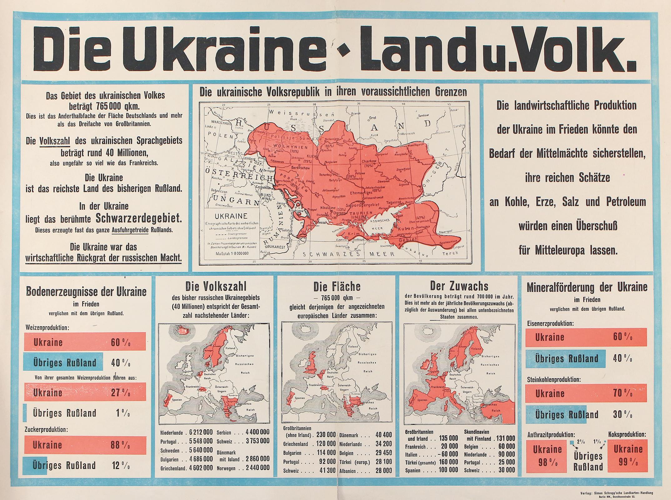
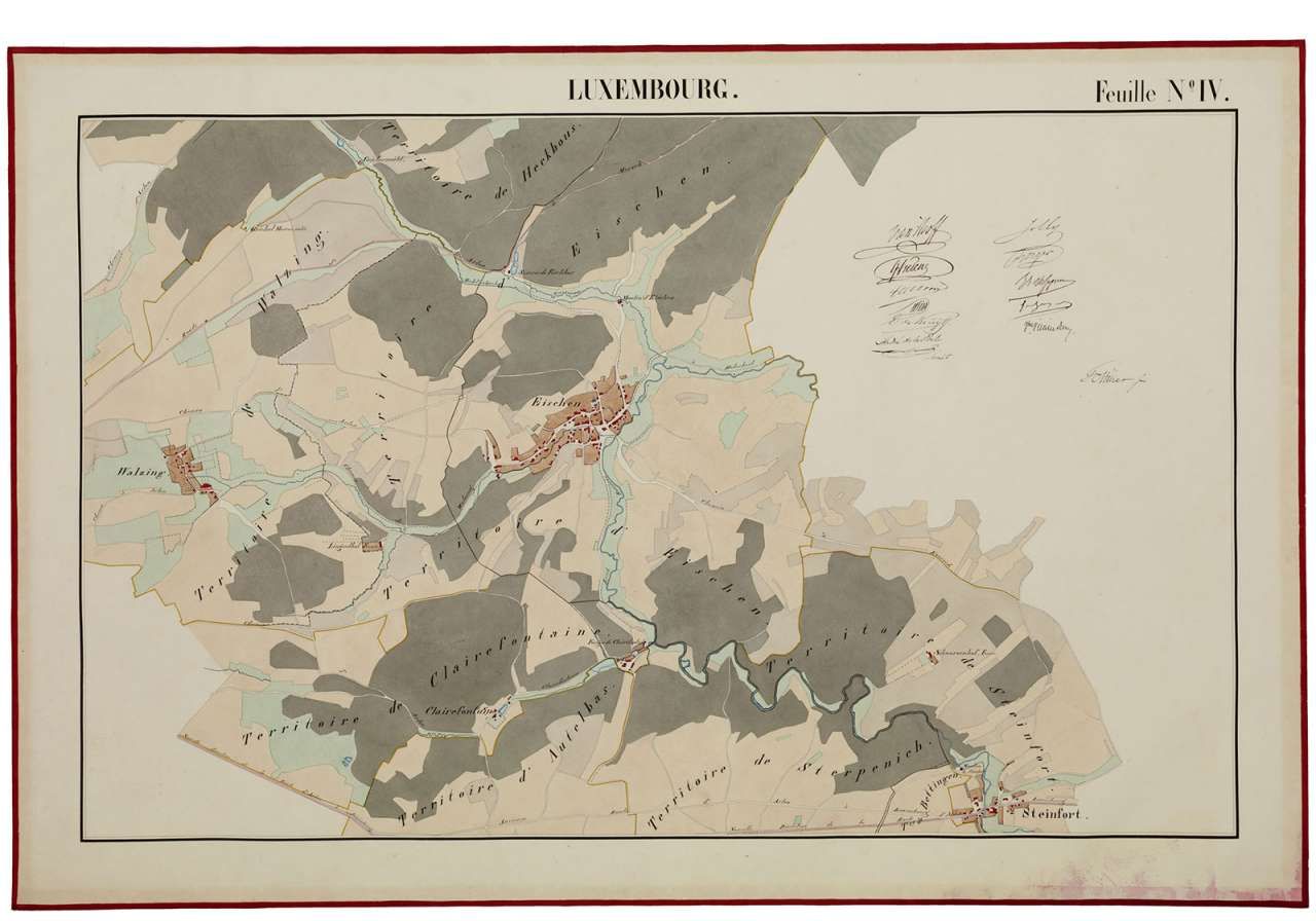
We will see maps of Ukraine and the Netherlands of the Perthes collection, the most important remnant of the German-language cartographic publishing tradition.
We will then be able to visit the monumental castle of Friedenstein, well preserved, with richly decorated rooms, one of the first baroque castles in Germany.

This year there is a superb exhibition called Luxury, art and fantasy in homage to Duke August of Saxony-Gotha- Altenburg, an impressive collector, mentioned by Goethe and Napoleon, who died in 1822.

Day ticket to visit the castle, the exhibition and the museum: EUR 10.00.

Access to Gotha:

  • by train: 6 to 7 hours from Brussels.
  • by car: approx. 5.30 hours from Brussels. Carsharing would be appreciated.

Accommodations in Gotha: from EUR 70.00 (Pension Am Ostbahnhof) up to EUR 155.00 (Hotel am Schlosspark).

The trip will take place if there are at least 10 participants.

A dinner is planned on Friday evening in Gotha.

If you wish to participate please fill the Registration Form before Thursday 15 September 2022.
We will acknowledge receipt of your registration shortly.

Interesting links:

Venue: Universität Erfurt, Forschungsbibliothek Gotha, Schlossplatz 1, Schloss Friedenstein, 99867 Gotha
Language: English
Time schedule: 10.00-16.00
Entry fee: EUR 10.00
Brussels Map Circle event


Venice, Italy
Organisation: The Brussels Map Circle
Due to unforeseen circumstances, we have to cancel the planned trip to Venice of October this year.
In close collaboration with our Italian sister organization Roberto Almagià, the city of Venice has been selected as the venue for a conference to be held in October 2022.


Berlin, Germany
Organisation: International Coronelli-Society for the Study of Globes and the Map Department of the Staatsbibliothek zu Berlin
In Berlin, the production of globes only began in the late 18th century, but developed into a very successful international production in the nineteenth century. The publishing houses of Dietrich Reimer, Ernst Schotte, Julius Heymann and - for the twentieth century - Columbus are particularly worthy of mention. This lively, but perhaps still somewhat under-researched publishing activity and the reopening of the Staatsbibliothek building Unter den Linden in 2021 are the reason to invite researchers of globe studies and all those interested to Berlin again after 25 years. The conference will take place in the Humboldt Hall of the Staatsbibliothek (Unter den Linden 8).
Two years ago, the Map Department was reunited in this building for the first time since the Second World War. The Map Department sees itself as one of the most active collections of cartographic works in Germany. While hardly any globes were included in the collection until the Second World War, it expanded thereafter to include significant objects (for example, the Sanuto brothers’ globe from the 1570s). Particularly in recent years, the focus of the collection has been on the Berlin production. Currently, the collection comprises about 280 globes produced up to the end of the Second World War. The Schnermann Collection, which comprises over 200 everyday objects of the twentieth century in the form of globes, also has a globe-relevant, if slightly curious, yet cultural-historical significance.
E-mail: vincenzo@coronelli.org


Hong Kong, China
Organisation: The Hong Kong University of Science and Technology
The publication of the first carto-bibliography of China, Regnum Chinae, marks the completion of the Western Maps of China research project.
This event celebrates the book launch as well as expresses our gratitude to Dr. Ko Pui-Shuen, the project sponsor.
Dr. Peter Van der Krogt, Research Leader, Explokart and Jansonius curator, Allard Pierson, University of Amsterdam, is an officiating guest of this event.
Venue: Kaisa Group Lecture Theater (IAS LT), Lo Ka Chung Building, Lee Shau Kee Campus, HKUST
Time schedule: 17.00
URL: https://library.hkust.edu.hk/events/conferences/regnum-china[...]


Washington, USA
Organisation: Geography & Map Division, Library of Congress
Virtual orientation introducing researchers to the Geography and Map Division of the Library of Congress.
This virtual orientation will provide a general introduction to the world's largest map library, focusing on collections and resources accessible online from anywhere. Join us to explore a treasure trove of maps, atlases, and cartographic resources followed by a Q&A session with a map librarian.
Time schedule: 15.00-16.00
URL: https://www.loc.gov/item/event-405558/geography-and-map-divi[...]


Bilzen, Belgium
Organisation: Stad Bilzen
Een boeiende lezing door historicus Gert Gielis (KULeuven) over het tijdsvlak waarin Sanderus werkte, de katholieke hervorming tijdens de Reformatie-Contrareformatie, en aandacht voor zijn universiteit en religieus-cultureel leven.
Historicus Gert Gielis is specialist van de zestiende-eeuwse Nederlanden. Na zijn studie Moderne Geschiedenis en een master in Medieval and Renaissance Studies aan de KULeuven werkte Gert bij het Leuvense universiteitsarchief en vervolgens bij het KADOC.
De lezing vindt plaats op zondag 9 oktober om 10.30 uur in de bibliotheek. De toegang is gratis, maar inschrijven is verplicht via bibliotheek@bilzen.be of +32 89 51 95 06.
Venue: Bibliotheek De Kimpel, Eikenlaan 25, 3740 Bilzen
Language: Dutch
Telephone: +32 89 51 95 06
Time schedule: 10.30-12.30
Entry fee: Free entry. Registration requested.
URL: https://www.uitinvlaanderen.be/agenda/e/lezing-historische-k[...]


Dresden, Germany
Organisation: Network Topographic Visual Media
Online Workshop Series of the Network Topographic Visual Media: Autumn / Winter 2022/23.
A lecture by Vera Dorofeeva-Lichtmann (CNRS, Paris), Ekaterina Simonova-Gudzenko (Institute of Asian and African Studies, Moscow State University).
E-mail: ntb@kunstgeschichte.org
Time schedule: 14.00-15.30 CET
URL: https://www.arthistoricum.net/en/networks/ntb/upcoming


Saint-Dié-des-Vosges, France
Organisation: Association pour le Développement du Festival International de Géographie
Fondé en 1990, le Festival International de Géographie est aujourd’hui l’un des festivals les plus importants du Grand Est.
Depuis plus de 30 ans, chaque début d’automne, cet évènement fête la géographie et accueille plus de 40  000 personnes. Son objectif : faire connaitre la géographie, moins considérée que l’histoire, et partager avec le public et les curieux avides de connaissances et de savoirs. Le pari était osé … il est gagné ! Saint-Dié-des-Vosges est devenue le rendez-vous des géographes, professionnels et amateurs. Un lieu d’ouverture sur le monde, une grande université à ciel ouvert pour tous et par tous !
Pour rester au cœur de l’actualité, le Festival s’articule chaque année autour d’une thématique et d’un pays invité. Pendant trois jours, les débats se font entre scientifiques, écrivains et artistes. Un bouillonnement intellectuel, culturel, littéraire et gastronomique.
La 33e édition aura lieu les 30 septembre, 1er et 2 octobre 2022 et donnera à réfléchir sur le thème Déserts. La direction scientifique 2022 sera menée par Julien Brachet, géographe, IRD, Université Paris 1. Le pays invité ? On l'attend depuis 2020 : le Portugal.
URL: https://www.fig.saint-die-des-vosges.fr/1481-deserts-et-port[...]


Saint Louis, USA
Organisation: The Society for the History of Discoveries co-sponsored by the Center for Medieval and Renaissance Studies
The 2022 Annual Meeting, will be held in the Pere Marquette Gallery at Saint Louis University, and co-hosted by the Center for Medieval and Renaissance Studies. The opening reception will take place on Thursday evening (29 September 2O22), followed by the conference the following two days, and a post-conference excursion on Sunday (2 October 2022).
Theme: At the Heart of the Continent: Native Americans and Newcomers in the Upper Mississippi Region
Often referred to as the Gateway to the West, Saint Louis was founded by French fur-traders in 1764, ceded to Spain within the year, returned to French control in 1800; then bought by the United States in 1803 as part of the Louisiana Purchase. It was a territory that was rich in people and natural resources. Directly across the Mississippi River from the city are the Cahokia Mounds, a major center of the Mississippian peoples who flourished in the area through the fifteenth century. Several Native American nations lived in this region in the historic era as well, including the Osage or People of the Middle Waters. Trajectories of cultural contact, trade, and exploration radiated in all directions from this land. This intriguing place offers the inspiration for the conference.
Venue: Saint Louis University, Saint Louis
URL: https://discoveryhistory.org/


Cluj-Napoca, Romania
Organisation: The Commission on Cartographic Heritage into the Digital of the International Cartographic Association
The Commission on Cartographic Heritage into the Digital of the International Cartographic Association, continuing the tradition of its annual Cartoheritage Conferences, since 2006, is organising the 16th Conference on Digital Approaches to Cartographic Heritage (ICA DACH) in Cluj-Napoca, Romania, 22-24 September 2022, in partnership with the Faculty of Geography, Babeş–Bolyai University, supported by the MAGIC - Map & Geoinformation Curators Group.
The Programme will be organised in thematic sessions dedicated to issues relevant to the subjects usually treated in the Conferences of the ICA Cartoheritage Commission, according to its Terms of Reference (2019-2023) and its Working Units.
Venue: Faculty of Geography, Babeş–Bolyai University, Str. Clinicilor 5-7, Cluj-Napoca 400006, Roumanie
URL: https://cartography.web.auth.gr/ICA-Heritage/Cluj-Napoca2022[...]


Orgères-en-Beauce, France
Organisation: Maison du Tourisme Coeur de Beauce
Lecture De la représentation du monde à la Beauce : histoire de la cartographie by Wulf Bodenstein.
This conference is linked to the exhibition entitled Par’chemins de Beauce which takes place from 14 July 2022 to 25 September 2022 in the same place.
Venue: Maison du Tourisme Coeur de Beauce, 5 Place de Beauce, 28140 Orgères-en-Beauce
Language: French
Time schedule: 18.00


Vienna, Austria
The International Cartographic Association (ICA), the Vienna University of Technology (TU Wien), the Austrian Academy of Sciences (ÖAW), the German (DGfK), Austrian (ÖKK), Swiss (SGK) and British (BCS) Cartographic Societies are pleased to invite you to the European Cartographic Conference EuroCarto 2022, 19-21 September 2022 at TU Wien, Austria.
The aim is to bring together Cartographers and those working in related disciplines to offer a platform of discussion, exchange and stimulation of research and joined projects.
The conference builds upon the successful EuroCarto 2015 and EuroCarto 2020 and takes the ICA initiative on fostering regional cartographic conferences on board.
Venue: TU Wien
URL: https://eurocarto2022.org/
Brussels Map Circle event


Sint-Niklaas, Belgium
Organisation: The Brussels Map Circle
Carl Dierickx has accepted to guide us through the exhibition Recht door Zee in Sint-Niklaas. It will take about two hours. Our Member Jan De Graeve would do the Mercator part.
The visit is reserved for Members of the Brussels Map Circle.
Language: English and Dutch
Contact: secretary@bimcc.org
Time schedule: 14.00
Entry fee: EUR 6.00


Berlin, Germany
The 20th Kartographiehistorisches Colloquium, initially planned to take place in Basel from 14 to 17 September this year, has had to be rescheduled and will be held at the Staatsbibliothek zu Berlin from 31 August to 3 September. The final programme and registration forms will be posted on www.kartengeschichte.ch by end of April. In case personal participation should not be possible due to new Corona restrictions, the event will be virtual using on-line techniques.
Venue: Staatsbibliothek zu Berlin
URL: http://www.kartengeschichte.ch/dach/


Chicago, USA
Organisation: The Newberry Library
A 2022 Summer Institute at the Newberry Library
The Newberry Library is pleased to announce Mapping the Early Modern World, a four-week summer institute for higher education faculty from 18 July through 12 August 2022. The institute will be held on site at the library, situated on the near north side of Chicago. The interdisciplinary institute will be co-organized by the Newberry’s Hermon Dunlap Smith Center for the History of Cartography and its Center for Renaissance Studies. Dr. James Akerman (Director of the Smith Center) and Dr. Lia Markey (Director of the Center for Renaissance Studies) will co-direct the institute. The institute’s 25 participants will pursue a program of seminars, workshops, discussion, and research exploring interdisciplinary approaches to the study of maps in connection with the global intellectual, cultural, and geographical transformations of the world between 1400 and 1700. The course of reading and discussion will consider five major “theaters” in which the production and use of maps operated: the world, the city, the land, the sea, and the skies. The co-directors have invited eight accomplished guest faculty from a broad range of humanities fields to lead seminar sessions and research workshops. In addition to these sessions, each participant will pursue a research project utilizing the Newberry’s renowned collections of early modern maps and other humanities resources.
URL: https://mappingearlymodernworld22.wordpress.com/


Durham, UK
Organisation: Jana Hunter (University of Oxford) and Christian Drury (Durham University)
Travel was central to shaping identity in Europe between the mid-nineteenth and mid-twentieth century. Representations of place, as well as personal, cultural and institutional connections, informed and structured travel at this time. Travellers within Europe and from outside shaped an understanding of what Europe was and is in a global, imperial context. As Kate Hill has put it, under the influence of technological and colonial change, spaces, narratives themselves, and cultural encounters all took on a greater measure of flux as the nineteenth century progressed. The provisional nature of the modern categories of home and away were forged in the nineteenth century.
Venue: University of Durham
URL: https://mtml2022.wordpress.com/


Leeds, UK
Organisation: Dr Elisa Ramazzina (University of Oxford and Queen’s University Belfast); Professor Karen Pinto
Borders are difficult to define, yet they have tangible resonance at various levels. Their function is ambivalent as they allow both alienation and integration. In the Middle Ages the situation was even more intricate, so much so that there are scholars who even deny the existence of boundaries in this era. Nevertheless, the role of borders in shaping particular critical events, such as political-religious conflict, the development of national kingship and the spreading of disease, is undeniable. It is also evident how these events have, in turn shaped or modified such borders.
URL: https://www.imc.leeds.ac.uk/imc-2022/


Leiden, The Netherlands
Organisation: Friends of Hadhramaut and Dr Alex Ingrams (Local Coordinator Netherlands)
A lecture by Dr Holly O’Farrell, Leiden University.
Discussion moderated by Dr Alex Ingrams, Leiden University
Mabel and Theodore Bent travelled through Europe, Arabia and parts of Africa establishing Theodore as a published writer on a wide variety of ancient civilisations and a collector for numerous museums. While Mabel had travelled alongside him, had taken part in digs, and had been instrumental in taking the notes that Theodore would depend on to write his books, little has been done to highlight her involvement and agency in their adventures. This presentation will look at the unprecedented journey of the Bents through the Hadhramaut region using Mabel Bent's travel chronicles and collections to understand this couple and their relationship as travellers, archaeologists and collectors.
Venue: Leiden University, Plexus Building, Kaiserstraat 25, 2311 GN Leiden
Time schedule: 14.30-16.00
Entry fee: EUR 15.00
URL: https://hadhramaut.co.uk/events/
Brussels Map Circle event


Paris, France
Our President Prof. Wouter Bracke confirms that the Brussels Map Circle will have a private tour Saturday 2 July 2022 at the BnF in Paris for the exhibition Visages de l'exploration au XIXe siècle. Du mythe à l'histoire with Olivier Loiseaux at 11.00.
Olivier Loiseaux, curator of the exhibition, is Chef du service Acquisitions et collections géographiques du Département des Cartes et Plans de la Bibliothèque nationale de France.
It is proposed, if it suits you, to meet at the Gare du Midi/Zuidstation in Brussels for the Thalys train leaving Brussels at 8.43 which arrives Gare du Nord in Paris at 10.06.
Or alternatively in Paris at the Bibliothèque François-Mitterrand, Hall Est, at 11.00 (entrance on the side of rue Emile Durkheim) in front of the maquette.
The visit is reserved for Members of the Brussels Map Circle.
Venue: Bibliothèque François-Mitterrand, Quai François Mauriac, 75706 Paris Cedex 13
Language: French
E-mail: secretary@bimcc.org
Time schedule: 10.45


Vienna, Austria
Organisation: Committee for the Study of Islam in Central Eurasia (ÖAW)
The summer school is designed to explore a range of scholarly approaches to the hermeneutics of records and the formation of archives on Islam in the territories of the former Russian Empire in the early modern and modern period. Here the term “archive” is used in a broad and all-encompassing sense, which includes all possible activities of record-keeping. The goal of this initiative is to draw attention on practices of information-gathering and knowledge production on the Muslim communities inhabiting the vast area encompassing Inner Asia, Siberia, Central Asia and the Caucasus from the fall of the Khanate of Kazan (1552) to the end of the Russian Empire. In addition, by bringing archival science into conversation with Russian and Islamic studies, the summer school promotes an extended reflection on the institutions and the individuals (archivists, historians, Orientalists, dragomans, and go-betweens of all walks of life) who played a significant role in the creation of the imperial repositories that today preserve records about Islam and Muslim communities in Central Eurasia.
By offering hands-on reading sessions and masterclasses, which are based on material in Russian, Church Slavonic, Eastern Turkic (Tatar and Chaghatay), and Ottoman Turkish, the summer school offers a wide range of activities to familiarize students with writing, documentary, and archival practices in Tsarist-ruled Central Eurasia. Reading sessions will offer ample room for practical exercises in the fields of palaeography and diplomatics. Special attention will be given to records crafted in Cyrillic handwriting (including skoropis) as well as in the Arabic script.
The ideal target of the summer school is a group of max. 10/12 graduate students.
The basic requirement is knowledge of Russian and one Turkic language and willingness to work with records in manuscript form.
Applicants are required to submit a CV, a motivation letter, and a letter of recommendation to paolo.sartori(at)oeaw.ac.at
Venue: Austrian Academy of Sciences, Vienna
URL: https://www.oeaw.ac.at/sice/events/summer-school


Barcelona, Spain
Organisation: Universitat de Barcelona, GEHC
The Cartography History Study Group (Grup d’Estudis d’Història de la Cartografia, GEHC) is preparing, in collaboration with the Insititut Cartogràfic i Geològic de Catalunya, a new colloquium with the title City and territory in Spanish cartography: a historical perspective. The event will be held on 9 and 10 June 2022.
The Cartography History Study Group has dealt with in previous colloquia the central theme of the history of urban cartography. The present colloquium is dedicated to one aspect of this cartography: that which relates the city to its nearby territory, in such a way that its field of study is broadened towards cartography at a regional level. It would try to analyse the cartographic production resulting from the relationships between the city and its territorial environment. Examples of this type of cartography would be communications maps (railways, roads ...), drinking water supply, sanitation, environmental planning (prevention of natural risks, protected areas ...), port and airport spaces, administrative districts of all kinds derived from the urban authority, strategic military with a wide territorial scope ...
As in previous colloquia, an attempt will be made to better understand the scope of this type of cartography, the causes that motivated it, the cartographers and institutions involved in its elaboration, as well as the cartographic techniques and language used. A knowledge that constitutes, in our opinion, an instrument of great interest for those geographers, architects, urban planners and historians interested both in the knowledge of the history of cartography and in that of the transformations of the landscape of cities and their surroundings.
URL: http://www.ub.edu/gehc/en/news/788-save-the-dates-for-the-ne[...]


(online) Leuven, Belgium
When the first galleons crossed the Pacific in the sixteenth century, new routes of exchange started to be formed, connecting Asia and the Americas. These networks also brought about new impulses in the history of mapmaking. Galleons and other vessels surveyed the waters, lands, and coastlines along their routes, and the resulting knowledge was then adapted in ports on both sides of the Pacific Ocean. Thereupon, this new or revised knowledge circulated further and affected regions and mapmakers that were not directly connected to transpacific navigation. Mapmakers adapted information on navigation and coast lines, and added, removed, or revised islands, harbours, or other specifications. Exchanges also had a profound effect on port cities themselves, an effect that we can observe, for example, in city maps, which mark trading posts, ships, or quarters for foreigners. Individual maps could be captured from ships or be passed on as gifts along these routes, and these artefacts themselves can tell a story of exchange across the Pacific World and beyond.
URL: https://crossroads-research.net/call-for-papers-mapping-prac[...]
Brussels Map Circle event


Brussels, Belgium
Organisation: The Brussels Map Circle
The MAPAF will be organised in close cooperation with the Maps and Plans Department of the Royal Library of Belgium who will show some very interesting items from their collection. On the other hand, every participant is invited to bring along a map, object, book or anything else of cartographic interest of his own to be presented and discussed by the present fellow members.
Always an excellent occasion to learn more in a convivial atmosphere. If you have the intention to show an item of your collection, please let it know to the organising team.

Practical:
  • Public transport: Central Station and metro station Central Station / Centraal Station / Gare Centrale.
  • Public parking: Interparking Albertine-Square.
  • No entrance fee for Members.
  • Entrance fee for non-Members: EUR 5.00.
  • Fees are to be prepaid on our bank account before the MAPAF: IBAN BE52 0682 4754 2209 BIC GKCCBEBB. No cash payments during the event please.
Venue: Map Room / Cartes et Plans / Kaarten en Plannen, KBR (Royal Library of Belgium), Mont des Arts /Kunstberg, 1000 Brussels
E-mail: mapaf@bimcc.org
Time schedule: 14.00-16.00
Brussels Map Circle event


Brussels, Belgium
Organisation: The Brussels Map Circle
The Annual General Meeting (AGM) opens only for Brussels Map Circle active members. All members are encouraged to become Active Member by applying to the President at least three weeks before the meeting.
A personal invitation to this AGM with the agenda and the possibility of proxy vote will be sent out to all Active Members by separate mail at least two weeks before the meeting.
Venue: Boardroom / Raadzaal / Salle du conseil, Royal Library of Belgium, Mont des Arts / Kunstberg, 1000 Brussels
E-mail: president@bimcc.org
Time schedule: 10.00 - 11.45
URL: http://www.bimcc.org/events


Milwaukee, USA
Organisation: American Geographical Society Library
A lecture by Dr. Katherine Parker, Research Officer, Barry Ruderman Antique Maps Inc.
Throughout the early modern period, sightings of and encounters with Patagonians and Fuegians were some of the most frequent European-Indigenous interactions to come out of Pacific voyages. Going through the Strait of Magellan or around Cape Horn was a pivotal moment in these voyages and the early interactions with local peoples, who already had semiotic baggage in the eyes of Europeans based on their first encounter with Magellan’s crew, were often offered with considerable detail in ship’s journals and printed accounts. How, then, were these encounters marked on the maps that accompanied these accounts or on separately published cartographic materials? What did mapmakers consider of enduring significance to use as representative of the region? Did this significance change over time? If so, how? This talk will answer these questions by looking at maps of southern South America from the late-sixteenth to the mid-eighteenth century.
Dr. Katherine Parker (PhD, History, University of Pittsburgh, 2016) is a historian specializing in Pacific history, the history of the book and the map, and the history of empires in the long eighteenth century. Her current book manuscript examines the production of Pacific geographic knowledge by European empires in the century prior to the voyages of James Cook. She is the Research Officer at Barry Lawrence Ruderman Antique Maps and a Teaching Associate at Queen Mary University of London. She serves as the Book Reviews Editor for H-Maps and the Administrative Editor of the Hakluyt Society.
This will be the 32nd “Maps & America” lecture, supported by an endowment created by Arthur and Janet Holzheimer.
Venue: AGSL, Golda Meir Library, 3rd Floor, East Wing UW-Milwaukee, 2311 E. Hartford Ave.
Time schedule: 18.00 UTC-5h
Entry fee: Registration is kindly required.
URL: https://uwm.edu/libraries/agsl/maps-america-lecture/


(online) Stanford, USA
Organisation: Rumsey Map Center
A lecture by Grant Parker.
This lecture will canvas historical maps as sources of insight into lives, both enslaved and slave-holding, at the Cape in the early colonial period. Grant will consider how selected maps tacitly embed narratives on both a large and a small scale and how they reflect both continuity and change. The lecture will draw on Stanford University's map collections.
Grant Parker is an Associate Professor of the Department of Classics at Stanford University and a Faculty Affiliate of the Center for African Studies. The Center is partnering with Stanford's Master of Liberal Arts Program to bring a talk by Grant Parker titled Reimagining Slavery at the Cape of Good Hope.
Time schedule: 17.00 PST
URL: https://mail.google.com/mail/u/0/#inbox/WhctKKXPlpwrSBwlbJbV[...]


Lima, Perú
Organisation: PUCP - Instituto Riva-Agüero - Faculdad de Letras y Ciensias Humanas
El Simposio Iberoamericano de Historia de la Cartografía (SIAHC) se ha constituido en un referente regional de reflexión crítica sobre los mapas y su historia. Desde el 2006, el SIAHC se viene organizando cada dos años, para estimular la interlocución académica regional sobre las relaciones entre cartografía, tecnología, cultura visual y poder. Los idiomas oficiales del evento han sido el castellano y el portugués y la inscripción al evento ha sido totalmente gratuita para todos los participantes y asistentes. Cada simposio ha contado con un Comité Organizador Local y el apoyo de un Comité Científico Internacional encabezado por los organizadores de los simposios anteriores.
URL: https://simposio-9siahc.pucp.edu.pe/sobre-el-evento/edicion-[...]


(online) Oxford, UK
Organisation: Bodleian Libraries
This webinar will be focus on four very different maps of Oxford from the standpoint of why these maps were made. Each of the maps has its own tale to tell, some showing Oxford as it was; others showing Oxford as it might have been; and others how Oxford never was. Each has an agenda aiming to depict a city under the influence of the military, mass delinquency, motor vehicles or moles. Nick Millea, Map Curator, and Stuart Ackland, Principal Library Assistant, Map Room, will focus on each map’s aesthetic charms, their functionality, and how they have visualized such a well-known city in such unusual ways.
Join us to be surprised, alarmed and charmed in equal measure as we appreciate the purpose of these of maps but never lose sight of the powerful image they are able to convey.
Speakers:
  • Nick Millea, Map Curator, Bodleian Libraries
  • Stuart Ackland, Principal Library Assistant, Map Room, Bodleian Libraries
Free event, booking required
Time schedule: 17.00 BST
URL: https://visit.bodleian.ox.ac.uk/event/apr22/meet-the-maps-un[...]


Dublin, Ireland
Organisation: The Renaissance Society of America (RSA)
The Mediterranean islands have occupied, at least since antiquity, a central position within the political and economic imperatives of numerous civilizations. These military powers will establish various forms of maritime control over the Mediterranean space. From the Minoans to the Genoese and Venetian Thalassocracies, as well as the Ottoman Empire, the Mediterranean Sea became the scene of countless battles for control of its islands and surrounding waters (even still today). When thought as a separate entity, the island often refers to the idea of isolation, but it takes on a whole new meaning when it becomes plural: when we speak of the Mediterranean islands, we think of battles but also of commerce and cultural exchange. Likewise, the water that surrounds the islands can be both a vector of isolation and a way for communication. In the early modern period, cartographic representations of these islands, coveted by foreign powers but also inhabited by different cultures and religions, are still linked to power relations and are part of the attempts of different powers to assert their territorial legitimacy.
The question of the territorialization of the seas, which began in the 17th century with Hugo Grotius, already exists, however, through early modern cartographic representations, whether we speak of isolarii, nautical charts, Geographies or wall paintings. To control an island is also to control the surrounding waters: in the same way, to represent an island is also to represent the maritime space that surrounds it, whether it is empty, filled with hatching, figurative details or simply colored. What is the relationship between the island and the surrounding waters? Does the latter make it an enclosed place, a fortified wall, a place of exchange? What about the islands of the Indian Ocean, or those of the New Territories? Is this plural idea of the relationship between the island and the sea to be found in the representations of other maritime spaces at the same time?
Venue: The Convention Centre Dublin, Spencer Dock, North Wall Quay, Dublin 1
URL: https://www.rsa.org/news/569805/RSA-Dublin-2022-Announcement[...]
Brussels Map Circle event


Ghent, Belgium
Organisation: The Brussels Map Circle
From Ghent to East India. In 1721, Michael de Febure from Ghent sets sail from the port of Ostend on a trade mission to East India. His diary will lead you on a most unexpected expedition.
You will experience the constant fear of privateers and pirates, explore the Cape Verde Islands and brave some severe storms. Along the way, you will discover the wonders of life at sea, before finally arriving at the Indian port of Surat, a melting-pot of cultures, smells, spices and exotic produce. While listening to the stories of Michael and his ship-mates, you will board a life-sized ship. Unique objects also bring the journey to life, from old nautical maps and model ships to exotic animals and exclusive discoveries from eighteenth century shipwrecks.
Entrance fee: EUR 10.00.

[30 January 2022 update]

Registration
If you would like to join this guided tour please register here before 23 February 2022. Those registered for the exhibition will receive a commentary on the maps on display to prepare for the visit. The visit will be preceded by a lunch at a local restaurant for those who wish to do so. At 12.00.
The parking under the museum is open.
Venue: Sint-Pietersplein 9, 9000 Gent
E-mail: info@bimcc.org
Time schedule: 14.30-16.30
URL: http://www.bimcc.org/events
Brussels Map Circle event


Ghent, Belgium
Organisation: The Brussels Map Circle
An Extraordinary General Meeting open only for Brussels Map Circle active members. A personal invitation to this meeting with the agenda and the possibility of proxy vote will be sent out to all Active Members by separate mail at least two weeks before the meeting.
Venue: Vrijzinnig Centrum Geuzenhuis vzw, Kantienberg 9, 9000 Gent
Time schedule: At 10.30
URL: http://www.bimcc.org/events


Sydney, Australia
Organisation: The State Library of New South Wales
Mapping the Pacific will examine the traditional wayfinding knowledge of the Pacific community, European exploration and the mapping of the Pacific from the early modern era through to the 19th century.
The conference is being hosted by the State Library of New South Wales in collaboration with the Australian and New Zealand Map Society and the Society for the History of Discoveries.
Venue: State Library of New South Wales, Macquarie St, Sydney NSW 2000
Language: English
Contact: Maggie Patton
E-mail: maggie.patton@sl.nsw.gov.au
URL: https://www.sl.nsw.gov.au/research-and-collections/research-[...]


Trieste, Italy
GSR objectives
  • to analyse and represent global maritime connections
  • to understand globalisation as a function of overseas expansion and the connected voyages, explorations and transportations from the late-15th century to the beginning of the 20th century
  • collecting data from printed travel accounts and manuscript ship logbooks
  • building a relational online database to be accessed on the Web.
Venue: University of Trieste-Department of Humanities)
Contact: Guido Abbattista
E-mail: gabbattista@units.it
URL: http://gsr.nodegoat.net/


(online) Melbourne, Australia
Organisation: The University of Melbourne
Buildings for industry, agriculture and trade in Australia, the Pacific and South-East Asia share an important but forgotten history of encounter, exchange, and influence. Industrial heritage is also underrepresented in World Heritage lists, with the Asia Pacific region poorly represented and global connections between industrial sites insufficiently understood (Falser & Yang, 2001). This symposium addresses these research gaps by providing a forum for academics, archivists, and heritage practitioners to share their examinations of unprecedented buildings for trade and industrial-scale resource extraction across Asia-Pacific’s multiple colonial entities and their successor nation-states.
The two-day symposium will feature international and local keynote speakers as well as panel discussions which explore flows and connections of commodity, craft, labour and expertise between sites and communities across Asia Pacific from 1800s – 1950s and beyond.
Convened by Amanda Achmadi, Hannah Lewi, Soon-Tzu Speechley, Paul Walker and the Australian Centre for Architectural History, Urban and Cultural Heritage (ACAHUCH) and the Faculty of Architecture, Building and Planning, The University of Melbourne.
With a lecture about maps …
‘Unlocking’ maps, locating forms: Assembling the Digital Historic Maps of Southeast Asia platform by Jane Jacobs, Professor of Urban Studies, Yale-NUS College Singapore and Victoria Marshall, Visiting Senior Fellow in Architecture, NUS Singapore.
What can historical maps tell us about the architectures of trade, commerce and resource extraction in Southeast Asia? Early maps can offer a great deal in terms of understanding the trade routes that moved resources, people and goods across the emerging global imperium of the Age of Exploration.
This paper explores this question through the newly developed Digital Historical Maps of Singapore and Southeast Asia platform, which seeks to enhance public and scholarly access to, and understanding of, historic maps of Southeast Asia currently held in distributed collections worldwide. The platform draws on the Southeast Asia historical map collections of our partner libraries: Beinecke Rare Book and Manuscript Library, Yale University; Bodleian Libraries, University of Oxford; Leiden University Libraries; and the National Library of Singapore.
The paper discussed how we have enhanced discoverability of the maps and curated specific featured content that charts new pathways of sense-making about intercolonial trade, industry and labour mobility in pre-1900s Southeast Asia.
E-mail: theo.blankley@unimelb.edu.au
URL: https://acahuch.msd.unimelb.edu.au/news-events/acahuch-sympo[...]


Frankfurt (Oder), Germany
Organisation: Luminita Gatejel, Leibniz Institute for East and Southeast European Studies, Regensburg; Stephan Rindlisbacher, Center for Interdisciplinary Polish Studies, European University Viadrina, Frankfurt (Oder)
Drawing borders is as difficult, as each individual case is exceptional. In our workshop, we explore the emergence of the borders that separated Eastern European empires and states over the centuries and shaped the daily life of those living in these regions.
The workshop will take place on-line on 26 November 2021.
Contact: Stephan Rindlisbacher
E-mail: gatejel@ios-regensburg.de
URL: https://www.hsozkult.de/event/id/event-97156


Bamberg, Germany
Organisation: UrbanMetaMapping Research Consortium, (sub-project) at the Centre for Heritage Conservation Studies and Technologies (KDWT) in Bamberg, in collaboration with the Leibniz Institute for Research on Society and Space (IRS)
Conflicts and catastrophes impacted cities worldwide throughout history and recently at various scales. The impact of the destruction of cities is documented globally and yet not fully analysed comparatively and from a long-term perspective. The development of new technologies facilitates the documentation of such damage, as well as preparation for the transformation and recovery of the cities. Urban damage cartography plays a fundamental role in communicating and negotiating losses and future visions of affected cities. Maps aim to track and foresee urban changes, yet they cannot compete with a fast-changing reality. Maps that depict war or natural related changes to the city could become obsolete in a short period. These can be read as a brief snapshot in a continuous changing environment. Due to this quick historization, damage cartography is situated at the interface of current documentation practice and historical geography, providing information as much about conditions before and after human-made or natural disasters, as about active changes made to the built urban fabric after catastrophes.
Existing historical sources of urban damage cartography for various cities generated during and after wars and conflicts have been identified and researched, such as those affected during the Second World War in Europe (Austria, Germany, Poland, United Kingdom). Building on this knowledge, this conference aims to problematise cartographies of catastrophes from the 19th century until the present time in the global context, from wide interdisciplinary perspectives. By focusing on damage maps from past and recent conflicts and catastrophes, this conference interrogates whether maps just show past conditions, or do they foresee and predetermine future conditions?
Venue: Centre for Heritage Conservation Studies and Technologies (KDWT), Bamberg, Germany
URL: http://conf.urbanmetamapping.uni-bamberg.de/conf/CoC/


Valletta, Malta
Organisation: The Casino Maltese
An exact replica of a unique 1504 globe ostrich egg world map by Leonardo Da Vknci will be the subject of a lecture by its discoverer Prof. Stefaan Missine. It is also the earliest globe showing the new world.
The lecture will be given at the Casino Maltese, Republic Street, Valletta at 18.30 on Wednesday 24 November 2021 and seats will be attributed on a first come first served basis. The general public will be welcome,
Dr StefaanMissine PhD is a Belgian resident in Austria and a Laureate of the Prinz-Albert-Gesellschaft / Prince Albert Society. He is an avid collector and authority on early maps and ancient globes. He is also the Author of a study of the silver globe of King James II (ca 1695).
Venue: Casino Maltese, Republic Street, Valletta


(online) Online via Zoom, Austria
This year´s Time Machine Conference 2021 invites the interested public to learn about the current key activities of the Time Machine initiative as represented by the Time Machine Organisation. Latest overall as well as country-specific progress updates will be shared, international large-scale project engagements of the Time Machine Organisation illuminated and possible project funding frameworks available for the Time Machine community presented. Last but not least, the buzzing essence of the Time Machine initiative – the Local Time Machines – will offer insight into their ongoing work and share their experiences and knowledge with the audience.
The Time Machine Conference 2021 will kick off on Monday, 22 November, with an introduction by our president Frédéric Kaplan offering an update on the Time Machine initiative embedded in the Time Machine Organisation. Our Time Machine Ambassadors will then continue by sharing information on how Time Machine and the Time Machine Organisation are currently developing in their respective countries.
The second part of the first conference day is dedicated to a more detailed look into international activities the Time Machine initiative represented by the Time Machine Organisation is involved in. Four topics are split into two parallel sessions: One session with a focus on Time Machine´s connection to large-scale funded international projects, the other session with a focus on the Time Machine Organisation Project Scouting Service and current project involvements.
Day two of the conference is devoted to exploring our Local Time Machines and Local Time Machine projects. Our Local Time Machines team will present the latest updates of the Local Time Machine community and Time Machine as a learning community implemented by the Time Machine Academies. Furthermore, news on recent technological developments such as Time Machine tools and the Request for Comments will be discussed.
The second day will be rounded off by parallel presentations of some selected Local Time Machines reflecting on topics relevant to their activities.
There will be ample time for Q&As after each presentation throughout the conference. The entire event will be recorded and made available publicly afterward.
Entry fee: Free. Registration is kindly required.
URL: https://www.timemachine.eu/events/time-machine-conference-20[...]


New Orleans, Louisiana, USA
Organisation: The Society for the History of Discoveries
The Gulf Coast of the southern United States, has been an area of intense human activity for millennia. Native Americans hunted and fished, developed agriculture and produced works of art in this region as early as 11 000 BCE. Vast trade networks stretched across the land and water. Europeans entered the scene in the sixteenth century with destructive expeditions led by Panfilo de Narváez and Hernando De Soto. Enslaved Africans were also brought to Spanish Florida in the sixteenth century. The Gulf Coast saw increased exploration and settlement; cultural exchange and exploitation – indeed, the ensuing centuries brought intensified and continuous change. This fascinating region offers the inspiration for our conference.
Venue: Williams Research Center of the Historic New Orleans Collection
URL: https://discoveryhistory.org/upcoming-meetings-conferences/


also online, Sevilla, Spain
Organisation: International Committee for the History of Nautical Science
Magallanes, Elcano, las circunnavegaciones y grandes exploraciones oceánicas (siglos XV-XX) [Magellan, Elcano, the Circumnavigations and the Great Oceanic Explorations (15-20th Centuries]
On 17 November 2021, Luis A. Robles Macías (Université Libre de Bruxelles), Editor of our magazine Maps in History and Member of the Brussels Map Circle, will present a lecture entitled Así se podrían y debe-rían hacer»: Los mapamundis de cuadrantes como alternativa a los náuticos en la Sevilla del siglo XVI.
URL: https://www.academia.edu/61408555/XIX_INTERNATIONAL_REUNION_[...]


(online) Warwick, UK
Organisation: The Hakluyt Society, the Global History and Culture Centre (GHCC) at the University of Warwick, and Medieval and Early Modern Orients (MEMOs)
The close links between travel and European colonialism have long been acknowledged. Since the early modern period, forms of global travel and exploration have often produced and reflected unequal structures of power: between those who chose to travel and those forced to, those who claimed lands and those whose lands were claimed, and those whose voices were amplified and others whose voices were erased. Post-colonial, feminist, and other critiques have exposed the inequalities inherent in the history of travel, whilst increased attention to women travellers and travel writing in Arabic, Persian, Chinese and other languages is changing the ways in which this history is written. Nonetheless, for reasons of institutional culture and the availability and accessibility of sources, the academic study of travel remains largely skewed towards the accounts and perspectives of European men from a small number of former imperial nations.
URL: https://hakluytsociety.wordpress.com/


Paris, France
Organisation: Librairie Loeb-Larocque and Le Zograscope
Specialist antique scientific instruments dealers as Tesseract, Antony Turner, Iris Globes, Wunderkammer, Ugo Padovan and Le Zograscope will be showing a fine selection of globes, surveying and other scientific instruments.
Librairie LeBail, Loeb-Larocque, Daniel Crouch, Gonzalo Fernández Pontes Libros y Mapas antiguos are only some of the 40 dealers who will be showing atlases, maps, town views and travel books from all parts of the world.
The map dealers Barry Ruderman, Neatline Antique maps, RD Rare Books and Maps and Geographicus from the USA, Vetus Carta from Canada and TMecca from South Korea are our non European participants much adding to the international character of the fair.
Venue: Hotel Ambassador, 16 Bd Haussmann - 75009 Paris
Telephone: +33 1 84 88 45 86
Time schedule: 11.00 - 18.00
URL: http://www.map-fair.com/map-fair.html


online, USA
Organisation: David Rumsey Map Center
The third biennial Barry Lawrence Ruderman Conference on Cartography will focus on the theme of Indigenous mapping. The conference, to be held digitally, is hosted by the David Rumsey Map Center at Stanford Libraries, which sits on the ancestral land of the Muwekma Ohlone Tribe. It is sponsored and co-organized by Barry Lawrence Ruderman Antique Maps Inc., whose shop is located on the ancestral land of the Kumeyaay peoples.
Entry fee: Free.
URL: https://library.stanford.edu/rumsey/public-events/barry-lawr[...]
Brussels Map Circle event


Brussels, Belgium
Organisation: The Royal Library of Belgium (KBR) and the Brussels Map Circle (BIMCC)
In October 2021 the Royal Library of Belgium and the Brussels Map Circle will host the 38th IMCoS International Symposium.
The 38th IMCoS International Symposium will highlight the early Belgian contributions to the development of cartography worldwide, such as the introduction of triangulation techniques (Frisius, van Deventer), first world atlases (Ortelius, Mercator) and the first navigation map in Mercator projection.
This Symposium is planned as a three-day event, commencing with an opening reception on the evening of 11 October 2021 at the Royal Library of Belgium (KBR), comprising speaker presentations at the KBR and visits to collections/institutions holding remarkable map collections: the State Archives of Belgium, the Art & History Museum and the Royal Army Museum. An official dinner will close the conference on 14 October 2021.
Further details on the dedicated website. Further details on the dedicated website.
Venue: Royal Library of Belgium (KBR), Mont des Arts 28, 1000 Brussels
Language: English
E-mail: imcos2021brussels@bimcc.org
Time schedule: 9.00 - 17.00
Entry fee: See website.
URL: https://web.archive.org/web/20221127094114/https://imcos2021[...]


Moscow, Russian Federation
Organisation: The International Research Laboratory “Russia’s Regions in Historical Perspective”
The Russian Federation today consists of over 80 federal units (sub”ekty federatsii), including republics, kraia, autonomous okrugs, oblasts, and so forth. Each of these forms of territorial organization has its own standing and place within the state hierarchy. But this represents just the most basic level of the state’s territorial organization. Each of these units in turn forms part of larger conglomerations or groupings of territories, such as federal or military districts, economic macroregions, or archbishoprics, as well as less determinate political-cultural entities such as the North, the South, Siberia, the Volga Region, and so forth, all of which occupy their own distinct niches within official and popular conceptions of the national area. The variety of these spatial formations and the different ways of “reading” Russian territory that they represent appear all the more striking when one considers the complex historical legacies that inform them. Even past spatial forms that are no longer visible today nonetheless remain deeply resonant and influential.
None of these ways of representing territory, past or present, is autonomous. Instead, each plays a role and has its assigned place within structures of meaning. As such, they reflect the reality that Russian space, like the territory of all states, is organized according to a range of hierarchies that together define the socio-political, economic, and cultural ordering of the state. It’s worth noting that the very understanding of region as a territorial entity is itself fundamentally relational. Put differently, no region can exist on its own. Every region is the product of likenesses, contrasts, and/or connections, real or imagined, with at least one other region. In a basic sense, there can be no North without a South, no center without a periphery. Europe would not be Europe without Asia, and so on.
Building from this conceptual foundation, our conference aims to explore the history of how different definitions of territory and the relations between them emerged and developed within Russian space over the preceding three centuries, taking into account the shifting effects of political and economic power as well as cultural values that defined this long period. We are especially interested in examining the factors that influenced how and why a given region might be seen to be higher or lower or of greater or lesser importance within the different imperial and national hierarchies that characterized Russian space during the imperial and Soviet eras, tracing the dynamics that shaped how these various hierarchies formed, evolved, changed, or, conversely, endured across time even through periods of otherwise momentous political and cultural-historical transformation.
Venue: Higher School of Economics, Moscow
Language: Russian and English
URL: https://www.hse.ru/en/rrh/announcements/480912051.html


online, Lisbon, Portugal
Organisation: Centro Interuniversitário de História das Ciências e da Tecnologia (CIUHCT)​
The main objective of the workshop is to bring together researchers interested in the history of nautical cartography. In this third meeting the scope has been enlarged to include not only the genesis and evolution of the medieval portolan chart but also nautical charts in general. The proposed themes of the workshop are:
  • When, where, how and why the earliest nautical charts were constructed, and how they evolved over time;
  • The mutual influence between medieval portolan charts and traditional maps of European and non- European origin;
  • How the first latitude charts were constructed following the introduction of astronomical navigation, and how they evolved over time;
  • The use of pre-Mercator nautical charts at sea;
  • The role of multidisciplinary approaches to the research on old nautical charts: cartometric methods of analysis, numerical modelling, multispectral analysis, material characterization, carbon dating, etc.;
  • Any other subject related to the history of nautical cartography, especially concerning pre-Mercator charts.
Online via Zoom or a mixed format will be considered. ​
Venue: Instituto Hidrográfico Marinha Portuguesa
Rua das Trinas, 49
1249-093 Lisboa
E-mail: portmeeting@ciuhct.org
URL: https://www.portmeeting.org/


Arlington, USA
Organisation: University of Texas
When Virginia Garrett donated her extensive personal collection of maps, geography textbooks, and atlases to UTA in 1997, a special endowment was established to promote its use by inviting scholars to speak on topics relating to the history of cartography. As a result, every other year since 1998, the UTA Libraries have hosted the Virginia Garrett Lectures on the History of Cartography along with a special exhibit drawn primarily from Mrs. Garrett's collection.
The 12th Biennial Virginia Garrett Lectures on the History of Cartography were slated for October 2020. In light of the current circumstances, the Garrett Lectures have been postponed to 30 September - 2 October 2021. This will be a joint meeting with the ICA Commission on the History of Cartography. The theme is Coordinating Cartographic Collections with an emphasis on map collectors and collections. A field trip to the Amon Carter Museum Conservation Lab is a small group pre-conference option. The current line-up of speakers include Jack Franke, Imre Demhardt, Wulf Bodenstein, Toyin Falola, Daniel Degges, James Harkins, Leah McCurdy, Barry Ruderman, Gerald Saxon and Martin Van Braunan.
Wulf Bodenstein, Member and former President of the Brussels Map Circle, will present a paper entitled New Life for an Old Map: the Retrieval of Pieter Verbist’s Unique 1644 Wallmap of Africa and its Place in the AfricaMuseum’s Map Collection.
URL: https://libraries.uta.edu/news-events/annual/virginia-garret[...]


online, Arlington, USA
Organisation: ICA Commission
On 30 September 2021 the ICA Commission is organizing the online workshop Coordinating Cartographic Collections, in conjunction with the 12th Virginia Garrett Lectures on the History of Cartography (University of Texas at Arlington) and the Fall Meeting of the Texas Map Society.
The ICA Workshop, due to the varying international Covid19 situation and travel restrictions, will be an ONLINE EVENT. The 12th Virginia Garrett Lectures & Fall Meeting of the Texas Map Society, however, are planned as a HYBRID CONFERENCE from 1 to 3 October 2021 (in-person attendance and online streaming). Presenters and registered participants of the ICA Workshop will get FREE online access to this conference as well.
URL: https://history.icaci.org/


online, USA
Organisation: California Map Society
Programme
  • 9.00 | Welcome by President Ron Gibbs and Vice President Courtney Spikes
  • 9.10 | Medieval Understanding of the World by Professor Emily Steiner, University of Pennsylvania, trustee of the New Chaucer Society and Director of the International Piers Plowman Society. Presentation followed by Q&A.
  • 10.00 | Indigenous Floridians in the Time Before Memory by Professor Andrew Frank, Florida State University, author of Before the Pioneers: Indians, Settlers, Slaves and the Founding of Miami (2017). Presentation followed by Q&A.
  • 10.50 | Break
  • 11.00 | Breaking the Third Wall: Going Beyond Traditional Hillshade by Sean Conway, Orthoimagery Technical Expert, transforming vintage maps into stunning three-dimensional relief by meticulously rendering elevation data with new technologies. Presentation followed by Q&A.
  • 11.50 | Closing
Time schedule: 9.00 - 12.15 Pacific Time


Wolfenbüttel, Germany
Organisation: Geschäftsstelle des SPP 2130, Institut für Germanistik
In the framework of the 3rd Yearly Conference (15-18.09.2021) of the SPP2130 Übersetzungskulturen der Frühen Neuzeit (1450-1800) / TRANSLATION CULTURES OF EARLY MODERN TIMES (1450-1800) (https://www.spp2130.de) several map-related papers will be presented. The zoom link is at the end of the program https://www.spp2130.de/index.php/en/current-topics.
URL: https://www.spp2130.de/index.php/en/current-topics/


Winston-Salem, NC, USA
Organisation: The Museum of Early Southern Decorative Arts
From the earliest mapping of North America by European navigators, to military campaigns during the French & Indian War and the American Revolution, to the exploration of the trans-Appalachian west, different communities used maps as tools to establish unique visions of the American South. This program brings together scholars from both sides of the Atlantic to explore how maps in the early South both created and reflected patterns of colonization, settlement, and migration. Patterns that remain on the landscape to the present day.
Speakers:
  • Margaret Pritchard, moderator
  • Susan Schulten, Keynote: “Maps that Made the South”
  • Philip Burden, Mapping North America in the Age of Exploration
  • Daniel Crouch, Visconte Maggiolo’s 1527 Map of North America
  • Brent Lane, John White’s 1585 Map of the North Carolina Outer Banks
  • Lucie Stylianopoulos, “A Tale of Two Maps: Finding the Indigenous Perspective in Carolina”
  • Katie McKinney, William Gerard de Brahm’s 1757 Map of the Lowcountry
  • Johanna Brown, Conservation of Andreas Hoger’s 1754 Map of Wachovia
  • Bill Wooldridge, “America as Eden”
  • Matthew Edney, John Mitchell’s 1755 Map of North America
  • Mike McNamara, Lewis Evans’s 1755 Map of the Middle Colonies
  • Christian Koot, “A Biography of a Map: Augustine Herrman’s Virginia and Maryland (1673)”
  • Dale Loberger, Applying Technology in the Search of Colonial Roads
  • Richard Brown, Mapping Southern Campaigns of the American Revolution
  • Daniel Ackermann, Mapping the South’s Westward Expansion
URL: https://mesda.org/program/mesda-fall-seminar/


Kyoto, Japan
Organisation: The International Institute for Asian Studies
The Silk Road has emerged as one of the key geocultural and geostrategic concepts of the 21st century. Built around narratives of maritime and overland trade and exchange connecting Asia with Africa and Europe, Silk Road discourses are rewriting histories, remapping futures. In the age of Belt and Road, they now operate as platforms for international trade, diplomacy, infrastructure development and statecraft.
The ascendancy of the Silk Road in international affairs means it is also fast gaining currency across academic disciplines, migrating outwards from Archaeology, Asian Studies and History into International Relations, Political Geography, Religious Studies, Public Health and Urban Studies, to name a few. Such developments raise important questions about how to interrogate and locate the Silk Roads, conceptually and empirically.
In China’s worldview the Silk Roads serve as both ‘shared heritage’ and ‘shared destiny’. So what does the idea of ‘reviving’ them for the 21st century tell us about global futures? How are we to read the Health Silk Road as a platform for COVID-19 medical cooperation across Asia and beyond? What’s really at stake in the Digital Silk Roads? And is the push for Silk Road narratives finally putting Asia at the centre of global history?
In exploring such themes, this panel takes the Silk Road as a topic of critical investigation. It addresses the urgent need to take Silk Road discourses seriously, interrogating the work they do crafting both pasts and futures around certain themes, ideologies and structural relations.
URL: https://www.iias.asia/events/icas-12


Tournai, Belgium
Le 11e Congrès de l’Association des Cercles francophones d’histoire et d’archéologie de Belgique, qui est aussi le 58e Congrès de la Fédération des Cercles d’archéologie et d’histoire de Belgique, doit avoir lieu à Tournai du 19 au 22 août 2021.
Les séances de travail sont réparties en 11 sections dans lesquelles vont être présentées quelque 215 communications. La circulaire n° 5 en a fourni la liste. Le tome 1er des Actes est actuellement sous presse ; vous serez ultérieurement tenu informé de sa publication, ainsi que de sa diffusion par le comité d’organisation.
Among the topics discussed at the congress are:
  • Aurélien Lacroix, Les franchissements de la Sambre belge : établissement d’une base de données cartographiques
  • Olivier Latteur, La pierre Brunehaut d’Hollain vue par les antiquaires et cartographes modernes : impact paysager, recherches érudites et souci de préservation (1600-1800)
  • Catherine Broué, Cartes et récits de l’exploration du Mississippi : un parcours curieux
  • Robin Moens, Au secours, la cartographie ! Une aide pour une meilleure compréhension de la géographie nobiliaire au Moyen Âge. L’exemple des seigneurs d’Audenarde, 1050-1300
Venue: IFAPME, rue Paul Pastur, 2, 7500 Tournai
Language: French
E-mail: info@congreswapi2020.be
URL: https://www.congreswapi2020.be


online, USA
Join the National Museum of the United States Army for our August Battle Brief about one of the most dramatic events of the Revolutionary War! Museum educator and historian, John Maass, will tell the story of Tarleton’s Charlottesville Raid of June, 1781, when British forces in central Virginia launched a daring strike to destroy Patriot supplies, disrupt the meeting of Virginia’s legislature, and capture Governor Thomas Jefferson. This program will also feature rare period maps and modern images of the key sites associated with this episode’s events.
Time schedule: 12.00 EDT
URL: https://www.thenmusa.org/events/


online, USA
Organisation: The Leventhal Map & Education Center
Join scholar Michele Navakas as she explores the “liquid landscapes” of places like Florida in the eighteenth century, helping us reframe our understanding of the American Revolutionary period through cartography and landscape history. Navakas examines a rich archive of historical documents that show how diverse groups of people met, struggled, and mixed in regions where boundaries themselves were hard to define.
Michele Currie Navakas is Associate Professor of English at Miami University (Ohio) where she teaches early American literature and environmental humanities. She is the author of Liquid Landscape: Geography and Settlement at the Edge of Early America (University of Pennsylvania Press, 2018), which won the Florida Historical Society’s Rembert Patrick Award and Stetson Kennedy Award.
Time schedule: 7.00 EDT
URL: https://www.leventhalmap.org/event/michele-navakas-on-liquid[...]


Foz do Iguaçu, Brazil
Organisation: El Comité Organizador de la 57 edición des Congreso Internacional de Americanistas (ICA 2021)
La representación de regiones fronterizas periféricas en la mirada hegemónica eurocéntrica como la Amazonia, la Patagonia, la Orinoquia, el Chaco, entre otras, ha pasado por formas de imaginación complejas de la otredad que implica su misma construcción periférica en relación a una centralidad narrativa que se asume privilegiada, así como por formas de clasificar y organizar sus naturalezas y gentes, lo cual a su vez se ha superpuesto con complejos procesos de fronterización que han definido, aveces de formas inestables, soberanías-imperiales-estatales en estas regiones. En esta propuesta de grupo temático queremos llamar a la reflexión a investigadores de diversas disciplinas sobre las formas de representación de estas regiones, privilegiando la representación a través de cartografías, para examinar tanto la relación de la construcción de dichas regiones con los diversos procesos de apropiación territorial del espacio material, como la expresión simbólica e iconográfica presente en las representaciones, tanto como las complejas redes de discursos, practicas y estrategias de diferentes actores asociados a la producción, distribución, reproducción e incluso recepción de estos materiales en diversos públicos que han logrado consolidar en los imaginarios sobre dichas regiones y sustentado las formas de apropiación, uso y explotación de éstas.
URL: https://ica2021.unicentro.br/en/


Bucharest, Romania
The International Conference on the History of Cartography will be organised in Bucharest from 4 – 9 July 2021
The International Conference on the History of Cartography (ICHC) is the only scholarly conference solely dedicated to advancing knowledge of the history of maps and mapmaking, regardless of geographical region, language, period or topic.
The conference promotes free and unfettered global cooperation and collaboration among cartographic scholars from any academic discipline, curators, collectors, dealers and institutions through illustrated lectures, presentations, exhibitions, and a social programme. In order to expand awareness of issues and resources, each conference is sponsored by leading educational and cultural institutions.
Venue: Central University Library ”Carol I”, Bucharest
E-mail: ichc2021@gmail.com
URL: https://ichc2021.com/


online, UK
Organisation: The International Map Collectors' Society
A lecture by Wes Brown.
In 1768 Mexican Jesuit priest Don José Antonio de Alzate y Ramirez created a large manuscript map of New Spain (defined at the time as those portions of North America controlled by Spain) which, in a bold move, he sent to the French Royal Academy of Sciences hoping that the learned society would publish it. For centuries, Spain had guarded its geographic knowledge about the New World and rarely allowed information to be published. Alzate’s outrageous breech of protocol resulted in the publication of the only printed map of New Spain using Spanish information in the eighteenth century. The map is rich with new geographic information of the area which would become the western United States. This presentation describes this extraordinary map in the context of the limited knowledge of that region of America at the time.
Time schedule: 20.00 – 21.30 CEST
URL: https://www.eventbrite.co.uk/e/imcos-map-lectures-wes-brown-[...]


online, USA
Organisation: David Rumsey Map Center
A lecture by Anton Thomas
Join artist/cartographer Anton Thomas for a talk about his newest project Wild World, a hand-illustrated map of Earth's natural geography and animals. He will discuss the origins of the project, drawing techniques, and many other challenges - from choosing a projection to deciding on animals.
Time schedule: 15.00 - 16.30 PDT
URL: https://events.stanford.edu/events/917/91749/


online, USA
Organisation: The Washington Map Society
A lecture by Leah Thomas, Assistant Professor of English, Virginia State University, and Editor, The Portolan.
Comparing contemporaneous maps of the southeastern United States with John Marrant’s narrative mapping in his A narrative of the Lord's wonderful dealings with John Marrant, a black: (now going to preach the gospel in Nova-Scotia) born in New-York, in North-America (London, 1785) offers insight into his location and travel especially among the Cherokee and their networks.
Taken into captivity by the Cherokee, Marrant is saved by the Chief’s daughter, echoing John Smith’s The generall historie of Virginia, New England & the Summer Isles : together with The true travels, adventures and observations, and A sea grammar (1624) during a pivotal moment in the colonial contest in the Southeast. Living among the Cherokee for approximately two years, Marrant hunted and traveled with them. His narrative mapping reflects the mapping in the 1720s deerskin maps attributed to the Catawba and Chickasaw that may have been of Cherokee origin.
Marrant’s travel with the Cherokee during the 1760s reveals emergent settler tensions with the Cherokee from their friendship with the British and negotiations with South Carolina Governor Francis Nicholson in the 1720s to their removal in the 1830s.
Via Zoom.
Language: English
Time schedule: 19.00 ET / 18.00 CT / 17.00 MT / 16.00 PT
URL: https://washmapsociety.org/event-4239037


online, UK
Organisation: The International Map Collectors' Society
A lecture by Paula van Gestel.
She will present aspects of her research for a cartobibliography on Dutch wall maps which she has been compiling with Günter Schilder since 2010. In addition to setting out their defining characteristics, manner of construction, sources, geographic and decorative content and the historical context, she will also discuss several prominent publishers of wall maps, the commercial environment, and issues of privileges and commissions.
Time schedule: 20.00 – 21.30 CEST
URL: https://www.eventbrite.co.uk/e/imcos-map-lectures-paula-van-[...]


online, Denver, USA
Organisation: The Society for the History of Discoveries
A lecture by Jordana Dym.
Discovery by historians is often imagined as solitary work in archives and libraries. An alternate model of field research takes archival research as a starting point. This talk explores the practice of a young professor of Spanish American history, Hiram Bingham, best known for publicizing Incan archaeology, on his first ‘expedition’ to South America, in 1906 and 1907, for a two-part mapping project. Bingham proposed to map key battles of Venezuelan independence leader Simón Bolívar and to determine whether, as Spanish American historians claimed, following an impassable road across Venezuela and Colombia was as wonderful as the more famous marches of Hannibal and Napoleon [over the Alps]. Between developing his hypothesis and disseminating his conclusions, the Bingham case allows us to consider the intersections between history, travel and cartography at the beginning of the 20th century.
Jordana Dym is Professor of History and Director of Latin American and Latinx Studies at Skidmore College (Saratoga Springs, NY). Her research interests include Spanish American independence, Atlantic revolutions, and the histories of cartography and travel. Forthcoming works include Mapping Travel: The Origins and Conventions of Western Journey Maps (Brill 2021) and, with Carla Lois, Bound images: maps, books and reading in material and digital contexts, Word & Image (2021). Additional information is available at https://skidmore.academia.edu/JordanaDym.
Time schedule: 12.00 US - Canada Central (Chicago) / 13.00 Eastern US Time / 18.00 (London) / 19.00 (rest of Europe)
Entry fee: This event is free and open to everyone, but registration is required.
URL: https://discoveryhistory.org/2021-virtual-lecture-series-3/


online, USA
Organisation: The Chicago Map Society
A lecture by Anne D. Williams.
The map of the United States, made into a puzzle with each piece an individual state, is a time honored device for teaching children geography. This talk covers map puzzles from their beginnings in the mid-1700s to the first World War, with emphasis on nineteenth century American puzzle ones. It focuses especially on the “Silent Teacher” puzzles that several companies in central New York manufactured from about 1875 to 1910. Most Silent Teachers were double-sided. They showed an individual state, cut on county lines, on the front, and an advertising image on the obverse.
Anne D. Williams is the author of The Jigsaw Puzzle, Piecing Together a History and numerous other publications on related topics. After completing an A.B. from Smith College and two years in the Peace Corps in India, she received her Ph.D. in economics from the University of Chicago. She spent most of her teaching career at Bates College in Lewiston, Maine, and retired in 2008. Her puzzling path began as a child and accelerated in two decades later when she started collecting jigsaw puzzles systematically and researching their history. Since then she has written two books on the history of jigsaw puzzles and curated museum exhibits in Maine, Massachusetts, and New York. She collected jigsaw puzzles from the 1700s to the present for more than forty years. Most of her extensive collection, including more than 100 pre-WWI map puzzles, is now in the permanent holdings of the Strong Museum in Rochester, NY.
Via Zoom.
Language: English
Time schedule: 18.00 CT
URL: https://www.chicagomapsociety.org/upcoming-events/
Brussels Map Circle event


online, Belgium
Organisation: The Brussels Map Circle
Wouter Bracke, President of the Brussels Map Circle, invites the Members to join by ZOOM the 2021 Annual General Meeting on 17 June at 18.00.
Agenda
  1. Activity report 2020
  2. Presentation and approval of the accounts of 2020
  3. Presentation and approval of the budget for 2021
  4. Discharge of EC Members
  5. Members Executive Committee : appointment
  6. Active Members
  7. A.O.B.
E-mail: secretary@bimcc.org


online, UK
Organisation: The International Map Collectors' Society
A lecture by Peter Geldart.
Towards the end of the Seven Years War, the East India Company (EIC) saw an opportunity, supported by the British government, to seize the Philippines from Spain. An invasion fleet was assembled in Madras and arrived in Manila Bay on 23 September 1762. Within ten days Manila had fallen, and the acting Governor-General, Archbishop Manuel Antonio Rojo, surrendered. The British went on to capture Cavite and the Manila galleon Santísima Trinidad, but faced resistance by a native army under Simón de Anda. Under the terms of the 1763 Treaty of Paris, Manila was returned to Spain on 31 March 1794 by the then Provisional Deputy-Governor, Alexander Dalrymple, who would later become hydrographer to the EIC and (in 1795) the first Hydrographer to the British Admiralty.
Peter will discuss the background to the invasion, the dramatic attack on the fortified citadel, subsequent events, the return of Manila to Spain, and the cartographic consequences of the occupation. To illustrate his talk, he will show maps from the British Library, George III’s Collection of Military Maps held by the Royal Collection Trust, the United Kingdom Hydrographic Office, the Norman B. Leventhal Map Center Collection at the Boston Public Library, the Library of Congress, and private collections in Manila.
Time schedule: 15.00 – 16.30 CEST
URL: https://www.eventbrite.co.uk/e/imcos-map-lectures-peter-geld[...]


online, Switzerland
Organisation: Priority Programme Transottomanica
Science, commerce, military, religion and authorities: in all these domains, everyday knowledge was from time immemorial collected and condensed into written knowledge. But content, structure and social relevance of knowledge are always historically contingent. The conference is asking thus for the importance of the Ottoman Empire in a history of European knowledge in the Early Modern Period. We focus on knowledge from or about the Ottoman Empire. We address two broader questions: from a spatial perspective, how can the Ottoman Empire be included into a European history of knowledge? From a social viewpoint: how was knowledge inside or about the Ottoman Empire organized and what kind of social functions can there be distinguished?
Spaces of knowledge. The development of Early Modern science was strongly influenced by (west-)European-Ottoman encounters. But to what degree was the Ottoman Empire an object of European knowledge systems? What contexts and players promoted or impeded the circulation of knowledge between the Ottoman Empire and other regions of Europe, including its Eastern parts? Which channels and forms were used for the communication of knowledge? What was the status of knowledge from or about the Ottoman Empire in European knowledge hierarchies and classification-systems?
Social functions. History of knowledge about the Ottoman Empire has long been focused on a classical history of science, technology and religion. Only recently, there is a shift towards conceptualising knowledge as a fundamental social practice for all kinds of human interaction. We are thus interested in social practices and discourses and their organizing or fragmentizing effects on social relations. What was the social relevance of different kinds of knowledge and which were the places of knowledge-production? Which kind of knowledge was privileged or legitimized by whom and in which contexts?
The Conference will be held on Zoom and is open to everyone interested. To get the Link to the Zoom-Meeting, please send a message to daniel.ursprung@hist.uzh.ch
E-mail: daniel.ursprung@hist.uzh.ch
Time schedule: 14.00 / 12.00 UTC
URL: http://www.osmanisches-europa.de/treffenmeetings/upcoming-me[...]


online, Montreal, [n.a.]
Organisation: The International Society for the History of the Map (ISHMap)
The Trustees of the International Society for the History of the Map (ISHMap) will hold the Society’s annual General Meeting on 10 June 2021.
The Meeting will held online.
Time schedule: 13.30 EDT (New York) / 14.30 (Rio) / 17.30 UTC (London) / 18.30 CEST (Paris/ Berlin)
URL: https://ishmap.wordpress.com/2021/06/03/ishmap-general-meeti[...]


online, Boston, USA
Organisation: The Norman B. Leventhal Map & Education Center
The exhibition Bending Lines: Maps and Data from Distortion to Deception examines how visual representations of the world can shape what people believe. But sometimes biases and distortions are built into the data that is used to produce a map. Far from offering a perfectly objective, all-encompassing view of the world, data sets of all kinds are deeply shaped by human choices.
In this conversation series, we talk with experts about why we should be careful about geographic information in modern data. How is data collected, and how does it get fixed into categories and numbers? Who gets to own data sets, and who gets to make decisions using them? What sorts of public responsibilities should shape the social lives of data?
A lecture by Brian Jefferson, associate professor of geography at the University of Illinois whose work explores capitalism, digital technology, and the state in urban contexts.
Time schedule: 12.00 EDT
Entry fee: Free
URL: https://www.leventhalmap.org/event/how-data-can-warp-our-wor[...]


(online) Cambridge, UK
Organisation: Faculty of History, University of Cambridge
A lecture by Diana Lange & Benjamin van der Linde (Hamburg/Hanseatic Business Archive Foundation).
In the frame of a hybrid conference held at the Faculty of History, University of Cambridge on 9 - 11 June 2021.
E-mail: hb528@cam.ac.uk
Time schedule: 16.40 – 18.45 BST / 17.40 – 19.45 CET / 11.40 - 13.45 EST
URL: https://networks.h-net.org/node/73374/announcements/7793368/[...]


online, UK
Organisation: The International Map Collectors' Society
A lecture by Daniel Crouch.
In January 2021 a set of ten ink and watercolour drawings were acquired by the National Museum of the Royal Navy. The re-discovered manuscripts are the earliest visual representations of the progress of the Spanish Armada and depict one of the greatest events in British naval history. The chronicle events from the sighting of the fleet at the Lizard on 29 July 1588 to the Battle of Gravelines on 8 August 1588. The drawings had, in 1828, been identified as preparatory sketches for Robert Adams and August Ryther’s engravings, Expeditionis Hispanorum in Angliam Vera Descriptio– the first commercially-produced English prints – published in 1590, to accompany Ryther’s description of the battle, A Discourse Concerninge the Spanishe Fleet. The lecture discusses the penmanship, provenance and production of the maps, and raises the possibility that, rather than being preparatory sketches for a printed work, they comprise separately-produced illustrations to accompany a now lost manuscript despatch of the campaign. In either case, both the drawings and the prints are shown to have played a vital role as part of Protestant propaganda and the Tudor spin machine.
Time schedule: 20.00 – 22.00 CEST
URL: https://www.eventbrite.co.uk/e/imcos-map-lectures-the-malcol[...]


online, San Domenico di Fiesole, Italy
Organisation: Roberta Biasillo (MWF RSCAS), Maria Vittoria Comacchi (MWF HEC), Lavinia Maddaluno (MWF HEC)
The 1990s mobility turn in the social sciences and the 2015-2016 migration crisis have increasingly brought to the fore the issues of displacement, travel, and immigration, which are part of society. Mobility patterns have affected geopolitical dynamics and shaped social, geographical, environmental settings, as well as processes in developing knowledge in significant and multifarious ways.
Announced by the European University Institute, Max Weber Programme for Postdoctoral Studies, Max Weber Multidisciplinary Research Workshop.
URL: https://networks.h-net.org/node/73374/announcements/6988700/[...]


online, USA
Organisation: The Chicago Map Society
A lecture by Dr. Asa Mittman, California State University.
This lecture is about how medieval Christian maps use principles of inclusion and exclusion to generate fictions of collective identity. This talk will examine cartographical images of Jews, thus far understudied but key to the creation of a central myth of the Middle Ages: Christendom.
Dr. Asa Mittman is a professor in the Department of Art & Art History at California State University, Chico. A former New Yorker, Dr. Mittman received his Ph.D. in Art History from Stanford University and has written a number of books and articles on monsters, art, and film about the vaguely defined period known as the Middle Ages. Some of his recent works include a book titled Maps and Monsters in Medieval England and co-editing the The Ashgate Research Companion to Monsters and the Monstrous. He also serves as a director of the Virtual Mappa Project, an online resource dedicated to the research of early medieval maps and geographical texts. Dr. Mittman’s current research, which he will be sharing with us, pertains to images of Jews on medieval maps and their relationship with Christianity.
Language: English
Time schedule: 18.00 CT
URL: https://www.chicagomapsociety.org/upcoming-events/


online, Paris, France
Organisation: École Pratique des Hautes Études (EPHE)
Conférences 2020-2021 animées par George Tolias, EPHE.
Le séminaire Représentation de l’espace : Moyen Âge – Époque moderne animé par George Tolias, directeur d’Études à l’École Pratique des Hautes Études (EPHE), sera dédié cette année à la cartographie de la Grèce insurgée et à la création de l’État grec moderne, dont on célèbre le bicentenaire (1821-2021).
Le séminaire aura lieu par visioconférence un jeudi sur deux, à partir du 19 novembre 2020, entre 11.00 et 14.00 h, heure de Paris, sur la plateforme GoToMeeting(*) de l’EPHE.
Programme
  • Jeudi 19 novembre 2020 - Politique, érudition, nationalisme et savoir faire 1775-1832
  • Jeudi 3 décembre 2020 - Archéologie et la Question de l’Orient. Les missions de 1775-1800
  • Jeudi 17 décembre 2020 - Anacharsiset Rhigas (1788-1811)
  • Jeudi 14 janvier 2021 - Antiquaires, architecteset topographes1790-1820
  • Jeudi 28 janvier 2021 - Pouqueville et Barbié du Bocage
  • Jeudi 11 février 2021 - L’espace revendiqué : les définitions grecques
  • Jeudi 4 mars 2021 - Champs de bataille et des villes assiégées
  • Jeudi 18 mars 2021 - Les cartes de la Grèce du colonel Lapie et de Franz von Weiss, 1821-1829
  • Jeudi 1er avril 2021 - Expédition scientifique de Morée : section des sciences Physiques, 1829-1832
  • Jeudi 15 avril 2021 - Expédition scientifique de Morée : section de sculpture et architecture, 1829-1832
  • Jeudi 13 mai 2021 - Expédition de Morée : les topographes militaires, 1829-1852
  • Jeudi 27 mai 2021 - Conclusions

(*) The GoToMeeting desktop app is available on Mac and Windows only! Unsupported on Linux!
Venue: [n.a.]
Language: French
URL: https://cartogallica.hypotheses.org/2358


online, Berkeley, USA
Organisation: California Map Society
Agenda
  • 9:00-9:15 am | Welcome – President Ron Gibbs and Vice President Tom Paper
  • 9:15-10:00 am | Jim Schein, Founder of Schein & Schein, and Tom Paper, Founder of The Digital Gallery, on The Cartographic History of San Francisco. Presentation followed by Q&A.
  • 10:00-10:45 am | Courtney Spikes, Historian and CMS Vice President, on The History & Cartography of Waterloo. Presentation followed by Q&A.
  • 10:45-11:00 am | Break
  • 11:00-11:45 am | Susan Schulten, American Historian, and Professor at University of Denver, on How Maps Made America. Presentation followed by Q&A.
URL: https://californiamapsociety.org/event-4228139


online, USA
Organisation: Cynthia Roman, The Lewis Walpole Library, Yale University and Holly Shaffer, Brown University
Topography, from topos, is the practice of describing place through language, the features of the land, the inhabitants, and the accumulation of history. Specific to locality and the perspective of the person delineating, describing, or collecting materials, topography counters the worldliness of geography while also offering a potential tool to multiply singular approaches.
In this second workshop in the series Viewing Topography Across the Globe, we will consider approaches to place from Indigenous and European perspectives and interrogate the frame of topography in global contexts. In two half-day virtual sessions, we will focus on topographical practices in the Americas as well as South and South-East Asia and the Pacific Ocean as well as how the materials of art-making both locate and disrupt notions of place. We will hear from artists and academics, work with colonial-era paintings, Indigenous objects, mapping, and literature, and consider Indigenous pedagogy.
Time schedule: 10.00 - 13.00 Eastern Time (US and Canada)
URL: https://walpole.library.yale.edu/programs/seminars-workshops


online, Chicago, USA
Organisation: Center for Latin American Studies, University of Chicago
Domains, an ARC-GIS/Esri Story Map (Classic) project created in 2017 by graduate students and faculty specializing in Latin American History at Florida International University, depicts the concentric, contested domains of legal jurisdiction in colonial Spanish America. This presentation first recounts the project’s origins inside and beyond the classroom, reflecting on the challenges of integrating the practice of digital mapping into diverse teaching environments and among scholars with analog sensibilities. It then discusses how Domains captures political and legal authority in a different way from traditional organizational charts or historical maps, enhancing its usefulness both as a teaching tool and research primer for those using the colonial archive. Finally, the presentation will reflect on the future of the project and the unique challenges that “class-made” digital maps like this face. Cosponsored by the Center for Latin American Studies and Department of Anthropology.
Time schedule: 12:30–13:40 CDT
URL: https://uchicagogroup.zoom.us/webinar/register/WN_dovQ6AEyQG[...]


online, Berkeley, USA
Organisation: California Map Society
Agenda
  • 9:00-9:15 am | Welcome – President Ron Gibbs and Vice President Tom Paper
  • 9:15-10:00 am | Benjamin Grant, Founder of Overview, on How We Change The Earth. Presentation followed by Q&A.
  • 10:00-10:45 am | Daniel Crouch, Co-Founder of Daniel Crouch Rare Books, on Contagious Cartography, A Panorama of Pandemics & Plagues. Presentation followed by Q&A.
  • 10:45-11:00 am | Break
  • 11:00-11:45 am | Steve Hanon, President of New York Map Society, on Maps of Spain in the Age of Discovery. Presentation followed by Q&A.
  • 11:45-12:15 am | Adjourn and CMS Business Meeting
URL: https://californiamapsociety.org/event-4228139


online, Washington, USA
Organisation: Washington Map Society with the Chicago Map Society
A lecture by James Akerman, Director of the Hermon Dunlap Smith Center for the History of Cartography and Curator of Maps at the Newberry Library, Chicago
For the past several decades, the Newberry Library has been collecting travel brochures advertising tourist attractions, points of interest, and other localities of potential interest to leisure travelers. Most of the library’s extensive holdings of these materials (numbering at least 100 000 items) are North American in origin and date from the late 19th to the early 21st centuries. In this presentation, Akerman will introduce us to this collection, by focusing on approximately 20 examples, offering a preliminary methodology for describing and drawing meaning from these ubiquitous yet widely disregarded sources at the intersection between mapping, cultural geography, and the history of travel and tourism. The presentation will consider three areas: (1) the physical relationship of the maps to the other elements of the brochure; (2) the authorship, design, and content of the maps; and (3) questions of meaning and interpretation. These are by no means an exhaustive list of what might be drawn from these objects but are offered as a starting point for conversation and further study.
Time schedule: 19.00 ET / 18.00 CT / 17:00 MT / 16:00 PT
URL: http://www.washmapsociety.org/WMSMeet.htm


online, London, UK
Organisation: The Warburg Institute
A course by Alessandro Scafi (Senior Lecturer in Medieval and Renaissance Cultural History).
The aim of this course is to explore how maps have served to order and represent physical, social and imaginative worlds from around 1200 to 1700. The focus is on the iconographic character of maps and the complex relation between art and science that is found in mapmaking throughout history. The students will be introduced to a wide range of images from different time periods and made for a variety of purposes, with the intent of drawing together art history, literature, philosophy and visual culture. Theoretical issues will be approached concerning, for example, the association of word and image, the definition of maps and their difference from views and diagrams, but the background and purpose of individual examples will be also discussed. These include medieval world maps produced as independent artifacts or drawn as book illustrations, mural map cycles of the Italian Renaissance, early modern prints made to identify and describe lands mentioned in the Bible. The course will investigate the creative and projective power of maps and their value as historical testimonies. Mnemonic and allegorical maps will be also approached.
The course will be taught across five x two hour classes online via the Zoom platform. Each session will have time for discussion. Reading lists will be made available to registered students.
Time schedule: 15.00 - 17.00 UTC
URL: https://warburg.sas.ac.uk/events/event/23596?utm_source=Warb[...]


(online), Rome, Italy
Organisation: Bibliotheca Hertziana Max-Planck-Institut für Kunstgeschichte
The workshop aims at extending the research horizons developed in the last years around the cartographic image, to deepen the methodologies of the so called cartographic turn and revise its categories of analysis in a transmedial perspective.
In the last decades, the reassertion of space as the gravitational centre of cultural enquiry and the consequent recognition of the constructed nature of spatial imaginaries, has contributed to the intensification of a real cartographic turn in the human and social sciences. In this context, the map emerges as a complex semantic structure that fruitfully travels across different media and visual grammars, translated from one cultural form to another. An attitude to hybridization with other media which today shows all its importance in the light of the new image formats emerging from the use of digital and interactive technologies. Following this line of enquiry, the workshop aims at extending the research horizons developed in the last years around the cartographic image, to deepen the methodologies of the so called cartographic turn and revise its categories of analysis in a transmedial perspective.
URL: https://www.biblhertz.it/3092990/remediated-maps-transmedial[...]


online, Stanford, USA
Organisation: The David Rumsey Map Center
Open to the general public on 7 April 2021, the David Rumsey Map Center is offering an online, live map-finding workshop over Zoom. It will walk participants through the different digital map resources available. It will share tips and tricks on searching and finding maps that are online with an emphasis on historical or rare maps.
You have to register.
Language: English
Time schedule: 11.00 - 12.00 US Pacific Time
URL: https://events.stanford.edu/events/905/90572/


Online, Denver, USA
Organisation: The Rocky Mountain Map Society
A lecture by Wes Brown.
Before the French Delisle family published maps of North America, California was shown as an island, the Mississippi River seemed to enter the Gulf of Mexico 500 miles too far west, and the North American interior was little known and confused. As the result of mostly French exploration in the continent’s mid-section around 1700, soon many geographical secrets would be revealed, and myths would be debunked. This 40-minute presentation provides the background and demonstrates how French father and son, Claude and Guillaume Delisle, produced superb maps that revolutionized understanding and were copied for decades.
URL: https://mines.zoom.us/j/95101310702?pwd=REpTMTBjcnJKTG5mOVZh[...]


Paris, France
Organisation: Émilie d’Orgeix et Nicolas Meynen
Colloque international sous la direction scientifique d’Émilie d’Orgeix (EPHE-PSL, Histara 7347) et de Nicolas Meynen (U. Toulouse Jean-Jaurès, FRAMESPA/UMR5136 CNRS).
En partenariat avec le Groupement d’Intérêt Scientifique « Patrimoines militaires : architectures, aménagements, techniques & sociétés » (GIS P2ATS).
Á l’articulation de l’histoire de l’architecture, des Interior Studies et des études muséographiques, ce cinquième colloque international du programme « Patrimoine militaire » (2012-2024) vise à stimuler les réflexions méthodologiques sur la manière de penser et de concevoir des reconstitutions d’intérieurs historiques militaires qui soient attentives à la mémoire plurielle des lieux et des hommes qui les ont façonnés au fil du temps. Il se fonde sur deux constats. Le premier est qu’il est aujourd’hui essentiel d’infléchir l’écriture d’une histoire de l’architecture qui a longtemps considéré l’étude des aménagements intérieurs et leurs évolutions successives comme un registre secondaire, voire dissocié du projet architectural. L’histoire des espaces intérieurs, la mémoire des lieux et des objets qui les composent, par nature temporaires, fragiles et soumis aux changements d’usage, de technique, de mode et de goût, sont encore trop rarement pris en compte dans les études préalables à l’ouverture publique de sites et de monuments. Dans la grande majorité des cas, l’acquisition et la reconstitution d’intérieurs est le fruit de politiques d’achats de mobilier par substitution, afin de restituer des « états matrices » à défaut de pouvoir documenter, dans le temps long, la mémoire des lieux et des hommes qui les ont habités (Lacaze, Poulot). Le second constat est qu’il est fondamental de reprendre l’ensemble de ces questions à l’aune des paradigmes propres au patrimoine militaire : des espaces techniques collectifs, utilitaires, fonctionnels, à l’obsolescence parfois programmée, souvent dégradés, désaffectés, vidés, pillés ou même détruits. Pourtant, en dépit du renouveau porté par le champ des Interior Studies, qui a largement renouvelé les approches muséographiques ces dernières décennies (Massey, Hollis), la question des intérieurs militaires reste toujours largement absente des débats. Ainsi, en 2016, sur la cinquantaine de réponses qu’a suscité l’appel à contributions du numéro de la revue In Situ consacré à la connaissance, à la protection, à la conservation et à la présentation au public des ensembles mobiliers, industriels et techniques, aucune ne portait sur le patrimoine militaire. Hormis quelques sites qui ont fait l’objet d’enquêtes archivistiques et archéologiques approfondies, telles ceux de Louisbourg (Nouvelle-Ecosse, Canada) ou de Suomenlinna (Helsinki, Finlande), l’ouverture au public s’accompagne rarement d’études préalables documentant tant la configuration des espaces meublés que les cadres et modes de vie des hommes qui y ont vécu. D’une manière générale, s’opposent aujourd’hui, de manière assez frontale, des reconstitutions muséales interprétatives épurées de toute quotidienneté à des bricolages foisonnants nourris par le florissant marché international des militaria.
En d’autres termes, ce colloque vise à concilier les approches et à réduire les écarts entre présentation isotope et générique d’espaces militaires meublés (modèles-types de casernes, gymnases, hôpitaux, casemates, corps-de-garde, bunkers…) et restitution de lieux et de cadres de vie temporellement et spatialement « situés ». Si ces problématiques croisent parfois celles d’autres typologies d’intérieurs (dont celles du patrimoine technique et industriel), elles en suscitent également de nouvelles. Les premières tiennent à la restitution de la technicité « phasée » de ces espaces. Comment rendre compte des aménagements successifs et des gestes performés dans ces « machines immobiles », pour reprendre le terme de Vauban, en l’absence de tout vestige d’armement, de matériel ou de mobilier ? Comment documenter et restituer l’acoustique et la disposition de cubatures aujourd’hui vides, la luminosité, les odeurs de poudre et les sons parfois assourdissants des casemates, tourelles de tirs ou blockhaus ? Les deuxièmes portent sur la restitution de la nature à la fois collective et individuelle d’espaces militaires où les hommes cohabitaient en permanence en grand nombre. Quel parti-pris et quel équilibre adopter pour évoquer l’« écologie » de milieux partagés tout en rendant compte de leur appropriation individuelle par les hommes qui y vivaient ? Dans quelle mesure et comment peut-on restituer la diversité des origines sociales, des habitus tout autant que la diversité des objets dans des reconstitutions souvent vidées des scories et des rebuts de la vie quotidienne des armées. Faut-il rendre peintures dégradées, graffitis, vitres brisées, mobilier le plus souvent produit en série et objets du quotidien modestes, cassés ou rafistolés, livres cornés, tentures trouées, tables écornées… ? Les troisièmes tiennent à la reconnaissance des acteurs qui ont aménagé ces espaces. Quels ont été les concepteurs des modèles, les inventeurs de solutions d’aménagements et d’objets militaires, et quelle est leur part d’inventivité et d’innovation ? Quelles sont les chaînes de fabrication et à quelles sphères professionnelles « extérieures » a-t-il fallu recourir ? Enfin, quel parti-pris adopter pour ne pas réduire artificiellement les multiples « vies » de ces espaces militaires à quelques uniques évènements historiques comme c’est souvent le cas ? Inversement, comment restituer et équilibrer la trame du temps long, les sédimentations successives des espaces, leurs processus de réaffectation ou leur délitement progressif ? Comment concilier « l’adaptation des espaces au discours et des discours aux espaces » (Giraudier) ? Et enfin, en corollaire, quels exemples retenir des récentes approches muséographiques, les scénographies foisonnantes inspirées des « cabinets de curiosités » ou le récent retour en force des period rooms.
Venue: Paris, INHA, Salle Vasari
URL: https://patmilitaire.hypotheses.org/2020-appel-colloque-patr[...]


online, Stanford, USA
Organisation: Sponsored by Hamid and Christina Moghadam Program in Iranian Studies, Stanford University Libraries, David Rumsey Map Center
The exhibition opening will take place Friday 26 March 2021 on Zoom and follows the schedule below:
  • 14:45 PST: Zoom opens
  • 15:00 PST: Talk by Alexandria Brown-Hejazi, followed by Q&A

The early modern world witnessed enormous changes in long-distance travel. Merchants, diplomats, and explorers from all regions of the world traversed new routes on land and sea, forging new global networks between European and Islamic worlds. This exhibition will examine the maps and cartographic studies of Ottoman Turkey, Safavid Persia, and Mughal India. The Ottomans, Safavids, and Mughals vied for control over the early modern Islamicate world. Known as the “gunpowder empires” for their successful use of firearm technology, these three powers constantly shifted between enemies and to allies, but always remained rivals.
This exhibition examines a series of cross-cultural artistic exchanges from maps that are not usually represented in early modern cartographic studies. The very content of the show challenges the notion of Europe as the epicenter of the Renaissance World. As such, the exhibition encourages viewers to question the historiography of Renaissance cartography. Four main themes steer the exhibition: revival of classical history and geography; anthropological study; trading companies and navigation; and finally, diplomatic encounter and exchange.
Time schedule: 14.45 PST
URL: https://events.stanford.edu/events/899/89972/


online, Ann Arbor, USA
Mary Pedley & Matthew Edney are joined by Karl Longstreth (Clark Library, University of Michigan) on the many challenges of digitizing maps and the advantages to research that such images bring.
Karl Longstreth is the Map Librarian in the Harlan Hatcher Graduate Library where he selects materials and provides bibliographic assistance for the Clark Library map collection, and more generally for environmental studies, geography and urban history in the Graduate Library.
Mary Sponberg Pedley is the Adjunct Assistant Curator of Maps at the Clements Library and co-editor with Matthew Edney of The History of Cartography Volume Four: Cartography in the European Enlightenment. Her research has focused on French and English map makers and map production in the long eighteenth century.
Matthew H. Edney holds the Osher Chair in the History of Cartography at the University of Southern Maine and is the Director of the History of Cartography Project, University of Wisconsin-Madison.
In April of 2020, after nearly twenty years of planning, writing, and editing, The History of Cartography Volume Four: Cartography in the European Enlightenment (University of Chicago Press) appeared. A massive reference work of 1651 pages, it comprises 479 entries with 954 full color illustrations, written by 207 contributors from 26 countries. In this webinar series, Co-Editors Matthew Edney (University of Southern Maine) and Mary Pedley (Clements Library) enjoy three conversations about the design, contents, and illustrations of this volume.
This online event is a Zoom Webinar with three sessions (9 March, 16 March, 23 March).
Time schedule: 16.00 ET
URL: https://clements.umich.edu/event/discover-series-cartography[...]


online, Ann Arbor, USA
Organisation: William L. Clements Library, University of Michigan
Mary Pedley & Matthew Edney are joined by Volume Four contributor on Ottoman mapping, Gottfried Hagen (University of Michigan), to explore the particularly special and unusual aspects of mapmaking in the long eighteenth century.
Gottfried Hagen is Associate Professor of Turkish Studies and teaches a broad range of courses on Turkish, Ottoman, and Islamicate cultural history, as well as Ottoman language. In his research, he asks how Ottoman culture constructed the globe and the universe, space, self, and others.
Mary Sponberg Pedley is the Adjunct Assistant Curator of Maps at the Clements Library and co-editor with Matthew Edney of The History of Cartography Volume Four: Cartography in the European Enlightenment. Her research has focused on French and English map makers and map production in the long eighteenth century.
Matthew H. Edney holds the Osher Chair in the History of Cartography at the University of Southern Maine and is the Director of the History of Cartography Project, University of Wisconsin-Madison.
In April of 2020, after nearly twenty years of planning, writing, and editing, The History of Cartography Volume Four: Cartography in the European Enlightenment (University of Chicago Press) appeared. A massive reference work of 1651 pages, it comprises 479 entries with 954 full color illustrations, written by 207 contributors from 26 countries. In this webinar series, Co-Editors Matthew Edney (University of Southern Maine) and Mary Pedley (Clements Library) enjoy three conversations about the design, contents, and illustrations of this volume.
This online event is a Zoom Webinar with three sessions (9 March, 16 March, 23 March).
Time schedule: 16.00 ET
URL: https://clements.umich.edu/event/discover-series-cartography[...]


Paris, France
Organisation: Centre de recherche interuniversitaire sur les champs culturels en Amérique latine (CRICCAL)
Le colloque se tiendra à la Maison de la Recherche et en ligne.
Le colloque L’usage des cartes. Cartographier en Amérique latine (XIXème – XXIème siècles) s’inscrit dans un souci de convergence de nos pratiques disciplinaires. Littéraires et historiens peuvent collaborer à cette réflexion : les premiers comme praticiens de la lecture et du déchiffrement, les historiens dans leur approche des cartes comme productions sociales, discursives et épistémiques.
Venue: Université Sorbonne Nouvelle – Paris 3, Maison de la Recherche, Salle Claude Simon, 4 rue des Irlandais, 75005 Paris
URL: http://www.univ-paris3.fr/xvii-colloque-international-du-cri[...]


online, Ann Arbor, USA
Organisation: William L. Clements Library, University of Michigan
Mary Pedley & Matthew Edney discuss the design and rationale for the encyclopedia format of the volume and the challenges and benefits of this structure.
In April of 2020, after nearly twenty years of planning, writing, and editing, The History of Cartography Volume Four: Cartography in the European Enlightenment (University of Chicago Press) appeared. A massive reference work of 1651 pages, it comprises 479 entries with 954 full color illustrations, written by 207 contributors from 26 countries. In this webinar series, Co-Editors Matthew Edney (University of Southern Maine) and Mary Pedley (Clements Library) enjoy three conversations about the design, contents, and illustrations of this volume.
Mary Sponberg Pedley is the Adjunct Assistant Curator of Maps at the Clements Library and co-editor with Matthew Edney of The History of Cartography Volume Four: Cartography in the European Enlightenment. Her research has focused on French and English map makers and map production in the long eighteenth century.
Matthew H. Edney holds the Osher Chair in the History of Cartography at the University of Southern Maine and is the Director of the History of Cartography Project, University of Wisconsin-Madison.
This online event is a Zoom Webinar with three sessions (9 March, 16 March, 23 March).
Time schedule: 16.00 ET
URL: https://clements.umich.edu/event/discover-series-cartography[...]


online, London, UK
Organisation: IMCoS
Come and join IMCoS for an event filled with maps! Ten presenters will speak for 5-10 minutes each about their chosen map/cartographic item. There will be time for questions and the event will be moderated. Join for a fun time to talk about and appreciate maps and mapping.
The event will take place via Zoom and is sponsored by the International Map Collectors Society (IMCoS). All are welcome, not just IMCoS Members. A Zoom link will be sent to registered ticketholders the day prior to the event.
Register for the event at the URL address below.
Time schedule: 19.00 - 20.30 CET
URL: https://www.eventbrite.co.uk/e/imcos-map-show-and-tell-ticke[...]


(online), Switzerland
Organisation: swisstopo
Conférence virtuelle depuis Neuchâtel de Laurent Tissot, professeur émérite d'histoire contemporaine de l'Université de Neuchâtel, ancien membre du comité international des sciences historiques et co-rédacteur du livre La Suisse sur la table de mesure, 175 ans de la Carte Dufour avec un chapitre intitulé 1845 = annus miserabilis ? Entre richesse cartographique et anémie touristique.
Introduction de Felix Frey et Lukas Gerber, swisstopo.
Clôture de Laurent Niggeler, Directeur du Service du Geomètre cantonal de la République et Canton de Genève
Venue: Les Salons du Général Dufour, Rue de Contamines 9a, 1206 Genève
URL: https://www.swisstopohistoric.ch/de/agenda/1845-=-annus-mise[...]


(online), USA
Organisation: The Society for the History of Discoveries
Historians of French overseas commerce and colonization have debated the advantages and disadvantages of French state-sponsored companies of commerce and colonization since the creation of these companies in the seventeenth century. Were these companies really more efficient at financing and organizing French overseas exploration and colonial ventures, or were they actually an impediment that help to explain why the British were so easily able to oust the French from most of North America?
This talk will focus on the seventeenth and eighteenth centuries, relating how and why the French crown created these companies and discussing the most recent scholarship regarding their role, especially in the exploration and colonization of North America.
Time schedule: 19.00 UTC; 13.00 CST
URL: https://discoveryhistory.org/2021-virtual-lecture-series/


Wien, Austria
Organisation: Anthropologische Gesellschaft in Wien
Vortrag von Prof. Dr. Stefaan Missinne, Globensammler und Forscher zur italienischen Renaissance.
Es ist der älteste Globus, auf dem die Neue Welt erstmals gezeigt wird. Über diese Jahrhundert-Entdeckung spricht Prof. Dr. Stefaan Missinne aus Belgien, der bei diesem Vortrag zum Leonardo da Vinci Globus aus dem Jahr 1504 seine Recherchen, publiziert bei Cambridge Scholards Publishing (2018), vorstellt. Als anerkannter Leonardo-Experte ist Prof. Dr. Stefaan Missinnes primärer Anknüpfungspunkt an das florentinische Universalgenie sein spezielles Interesse an Globen, Landkarten und Ikonographie ist. Nach dem Studium der Sozial- und Wirtschaftswissenschaften in Wien hat sich der 1960 in Belgien geborene und heute in Österreich wohnhafte Stefaan Missinne im Zuge jahrelanger Forschungen sowie als Kunstsammler vor allem mit Globen und Gemälden, aber auch mit originalen Renaissance-Zeichnungen und Kunstkammerobjekten beschäftigt. Missinne ist Laureat der Belgischen Prinz Albert Stiftung und Schüler des weltweit bekannten Leonardo Experten Prof. Dr. Carlo Pedretti.
Venue: Kinosaal des NHM
Time schedule: 18.30
URL: http://www.ag-wien.org/


Paris, France
Maps are multidimensional objects of study that entail scientific, artistic, political, diplomatic, military and economic stakes. On the scientific level, the cartographic techniques and their evolutions are related to the establishment of trades such as cartographers, geographers and land surveyors. Who makes maps, for which purpose and for whom are questions to consider in order to apprehend these documents. Secretly-used maps need to be distinguished from printed and circulated ones. The former are instruments in the hands of governments in the context of peace negotiations and military operations – as was the case for the maps on which the French and the Americans relied during the American Revolutionary War – but also in the context of the exploration and conquest of new territories, among which Northern and Southern America, as well as Africa and India. Most of the time, maps have been made public in books destined to a literate audience, but their degree of accuracy and their level of artistry need to be assessed.It can thus be considered that maps create spaces as much as they reflect them. Maps also circulate as separate objects such as terrestrial globes. This requires to think about the manufacturing of objects and the printing of maps but also to ponder over their commercialization, dissemination, exhibition in curiosity cabinets as well as their circulation in European and American learned societies.
Venue: Université Paris-Diderot
URL: http://1718.fr/cfp-2021-cartes-et-cartographies-dans-le-mond[...]


(online), Deutschland
Organisation: Centre for the Study of Manuscript Cultures (CSMC) and the Mineralogical Museum/Center of Natural History (CeNak) and the Museum am Rothenbaum, Kulturen und Künste der Welt (MARKK)
Maps and Colours (2018-2021) is a joint research project funded by the German Federal Ministry of Education and Research (BMBF) and pursued by the Centre for the Study of Manuscript Cultures (CSMC) and the Mineralogical Museum/Center of Natural History (CeNak) as part of Universität Hamburg, the Hanseatic Business Foundation Archive with the Library of Commerce, and the Museum am Rothenbaum, Kulturen und Künste der Welt (MARKK). The project examines maps of East Asian and European origin drawn, dyed, and coloured by hand between the 15th and 20th century with a particular focus on the colours and colourants used for their production. In doing so, the project pursues a multidisciplinary approach to provide novel insights into research areas that have been neglected thus far. These range from the origin, composition, and processing of colour pigments to their function, use, and associated meaning in order to re-trace historical trade routes and to illuminate questions pertaining to regionally specific print traditions, processes, and innovations. Particularly the material analysis of the colours and dyes breaks new ground for the study of coloured maps and prints. This research is carried out through predominantly non-invasive methods, including but not limited to microscopy, chemical analysis, and multispectral imaging.
Virtual lectures via Zoom, Tuesdays 16.00 - 18.00.
URL: https://www.manuscript-cultures.uni-hamburg.de/cal-details/L[...]


Paris, France
Organisation: Paris Map Fair
This 19th edition of the fair will be completely virtual !
Dealer setup : 7 December until 10 December 2020. Fair is open to the public : 11 - 15 December 2020.
Please have a look at the dealer info page with more information. Participation starting at USD 100.00 for a booth.
If you participate in the Paris map, globe and instruments Fair you will be able to participate in the first virtual San Francisco & Print Fair in October for free.
URL: http://www.map-fair.com/ENGvirtual2020.html


Stanford, USA
Organisation: Sponsored by Stanford University Libraries, David Rumsey Map Center
In this online talk, Nick Kanas will explore the evolution of celestial cartography. People have observed the night sky since antiquity in an effort to predict celestial events and understand their place in the universe. Many cultures organized the stars into heavenly patterns that reflected issues important to them. In ancient Greece, the stars were placed in constellations that were viewed as allegorical representations of classical Greek heroes, heroines, and monsters. These images formed the backbone of the cosmological and constellation maps that appeared in stunningly beautiful star atlases of the 17th and 18th centuries. But telescopic and scientific needs called for more accuracy in star placement, and gradually the heavenly bodies were positioned in increasingly accurate coordinate systems superimposed on the sky. Constellation images became redundant, and they have largely disappeared in today’s modern star atlases.
Time schedule: 14.45 UTC −08:00
URL: https://events.stanford.edu/events/891/89130/


Paris, France
Organisation: Comité Français de Cartographie (commission ‘histoire’) et Direction des bibliothèques et de la documentation du Muséum National d’Histoire Naturelle
Les jardins naturalistes, botanique et zoologique, partagent avec la cartographie la volonté de décrire le monde de manière à la fois exhaustive et ordonnée. Les échelles, les matériaux, les apparences de la représentation sont certes différents. Mais il s’agit bien, dans la carte comme dans le jardin, d’élaborer une image du monde qui puisse être lisible par tout un chacun. Cartes et jardins font partie de ce grand effort scientifique qui consiste à faire voir et faire comprendre le monde et ses espaces, naturels et humains.
La journée d’études organisée conjointement par la Commission Histoire du Comité Français de Cartographie et la Bibliothèque du Muséum National d’Histoire Naturelle se propose d’explorer les rapports qui se sont noués entre la cartographie et le jardin, notamment au Jardin des Plantes, du point de vue de l’acquisition, de l’organisation, de la représentation et de la diffusion des connaissances naturelles. La période étudiée pourra remonter aux origines médiévales de l’activité de collecte et de description du monde naturel, mais on insistera surtout sur les périodes modernes et contemporaines liées à l’institution du Jardin des Plantes et à son fonctionnement jusqu’à nos jours.
Deux directions sont à envisager : celle qui conduit du jardin vers le monde ; celle qui ramène, pour ainsi dire, le monde vers et dans le jardin. La cartographie est engagée à des titres et sous des formes multiples dans les opérations de description et de représentation des mondes naturels et humains. De la géologie à l’ethnographie, de la botanique à la zoologie : c’est l’ensemble du champ d’investigation ouvert aux naturalistes qui est devenu le théâtre de la mise en œuvre des opérations cartographiques. Il s’agirait alors, dans les contributions à cette Journée d’étude, d’analyser dans un premier temps les diverses façons dont les cartes, aux côtés des archives et autres documents de terrain, ont été mobilisées dans la construction des connaissances naturalistes. Les échelles, les supports matériels, les sémiologies, les modes d’écriture, mais aussi les usages, qui peuvent parfois différer du tout au tout, feront l’objet d’un intérêt particulier. Autrement dit : à quoi servent les cartes sur le terrain naturaliste et comment sont-elles conçues, fabriquées, utilisées, à quelles fins ?
Venue: Auditorium de la Grande Galerie de l’Évolution, Muséum national d’histoire naturelle
URL: https://f.hypotheses.org/wp-content/blogs.dir/244/files/2020[...]


Bogotá, Colombia
Organisation: Instituto Amazónico de Investigaciones – IMANI de la Universidad Nacional de Colombia Sede Amazonia, con apoyo de la Biblioteca Nacional de Colombia, el Centro Cultural Leticia del Banco de la República de Colombia, la Red Razón Cartográfica, el Laborator
Course on “Amazonia Cartográfica: tierras calientes, paraísos ignotos, y discursos geográficos”.
Los invitamos a participar del curso de extensión Amazonia Cartográfica: tierras calientes, paraísos ignotos, y discursos geográficos, organizado por el Instituto Amazónico de Investigaciones – IMANI de la Universidad Nacional de Colombia Sede Amazonia, con apoyo de la Biblioteca Nacional de Colombia, el Centro Cultural Leticia del Banco de la República de Colombia, la Red Razón Cartográfica, el Laboratorio Digital de Arquitectura y Urbanismo y el Grupo de Estudios Transfronterizos.
La transmisión de la sesión se hará a través de Facebook live [https://cutt.ly/Pfab9jN] y Youtube [https://cutt.ly/ZfabUyB].
Todos los jueves de 2020 a 16:00 a 18:00 (UTC-05).
Free. Upon registration at this address.
Organizado por Grupo de Estudios Transfronterizos e Razón Cartográfica
Time schedule: Thursdays between 16:00 and 18:00 (UTC-5)
Entry fee: Free.
URL: https://razoncartografica.com/2020/08/13/amazonia-cartografi[...]


Cambridge, UK
Organisation: Cambridge Seminars in the History of Cartography
A lecture by Julian Candiah (Kuala Lumpur and Cambridge).
For details on how to join, please send an email to events@emma.cam.ac.uk
Updated on 16 November 2020.
Venue: Emmanuel College, St Andrew’s Street, Cambridge UK CB2 3AP
Language: English
Contact: Sarah Bendall
E-mail: events@emma.cam.ac.uk
Time schedule: 17.30 (UK Time : GMT for first two talks ; BST for talk in May 2021)
Entry fee: All are very welcome: do come virtually.
URL: https://www.lib.cam.ac.uk/collections/departments/maps/carto[...]


New Hope, USA
Organisation: Society for the History of Discoveries
Louisiana is home to some of the earliest Paleo-Indian sites in North America, and the area which became New Orleans was settled by the Chitimacha people as early as 400 BCE. Spanish expeditions, under Panfilo de Narváez and Hernando De Soto, entered the area in the sixteenth century, and French fur traders began to settle in Native American villages in the delta region in the late seventeenth century. New Orleans was founded as a French city in 1718, was later ceded to the Spanish in 1763, and finally became a part of the United States under the provisions of the Louisiana Purchase in 1803. In the 1710s enslaved Africans were shipped to Louisiana in large numbers, and after the Haitian Revolution (beginning in 1791) French creoles and Creoles of color, fleeing the violence, settled in New Orleans. Germans, too, had a presence in early Louisiana, beginning in 1721, with the Karlstein settlements just north of the city. This culturally rich and unique region offers the inspiration for the conference.
Entry fee: Free.
URL: https://discoveryhistory.org/2020-conference-abstracts-bios/


Hamburg, Germany
Organisation: Museum am Rothenbaum - Hanseatic Business Archive foundation/Hamburg Chamber of Commerce - Centre for the Studies of Manuscript Cultures (CSMC)/Universität Hamburg
In the framework of our innovative interdisciplanry research project Coloured Maps we are organizing a workshop with a cross-cultural approach to discuss the material nature and meaning of colours on maps.
On the workshop we will discuss maps and colours, methods and discourses, dyes and analytrical approaches. We wil focus on European and Asian maps between 15th and 19th century.
Contact: Benjamin Vanderlinde
E-mail: benjamin.vanderlinde@hk24.de


Barcelona, Spain
Organisation: Institut Cartogràfic i Geològic de Catalunya
El mapa como elemento de conexión cultural entre América y Europa
Se pretende abordar la historia de la cartografía iberoamericana, entendiendo el mapa como un elemento de conexión cultural entre América y Europa. Los mapas coloniales, los mapas de las expediciones científicas o los mapas de los territorios independientes comparten historia, técnica y usos. En el simposio proponemos analizar estos hilos que tejen una historia común de la cartografía iberoamericana:
  1. De la cartografía colonial a la cartografía científica: el mapa como demostración de apropiación territorial.
  2. Las aportaciones autóctonas al conocimiento geográfico del territorio americano y su plasmación en la cartografía.
  3. Los mapas misionales entre la subordinación colonial, la obediencia eclesiástica y el descubrimiento del territorio.
  4. Modelos, influencias y diferencias en la cartografía urbana a ambos lados del Atlántico.
  5. La imagen de América en la cartografía publicada en Europa y la imagen de Europa en la cartografía publicada en América.
  6. La influencia del uso de las tecnologías en el estudio de los mapas antiguos: de la accesibilidad de los catálogos a la georreferenciación y vectorización de mapas.
Los idiomas oficiales del Simposio son el castellano y el portugués.
URL: https://siahc.icgc.cat/es_ES/
Brussels Map Circle event


Venice, Italy
Organisation: The Brussels Map Circle
Important notice [updated on 2020-07-21]
The latest evolution of the Covid-19 situation has forced the persons in charge of organising the joint meeting in Venice of Almagià and the Brussels Map Circle to finally abandon this project for 2020. We sincerely regret this, but the risks and difficulties were too considerable, despite all our best efforts. We keep hoping that in a not too distant future this event will be able to take place eventually. We hope our Members can understand this decision.
The Brussels Map Circle wishes to thank all the persons who invested their time and goodwill into this project, in particular Alex Smit, Emilio Moreschi and Vladimiro Valerio and the speakers who had already consented to come: Pieter Martens, Marica Milanesi, Daria Perocco, Hans Kok, Giorgio Mangani and Wouter Bracke.

In close collaboration with our Italian sister organization Roberto Almagià, the city of Venice has been selected as the venue for a conference to be held in October 2020. Venice is the city of many famous cartographers, such as Fra Mauro, Forlani, Bertelli, Gastaldi and Coronelli. collections. The two-day conference will focus on the interaction between cartographers of Italy and the Netherlands during the period 1550 to 1750, regarding exchanges, copying and pirating of maps, which took place extensively (and without shame).
The idea is to hold on Friday 16 October 2020 a full day of lectures in the prestigious Aula Magna of the Ateneo Veneto and on Saturday 17 October 2020 to make private visits to the famous Correr and Marcina Libraries. These both have very rich cartography collections and Marciana also the famous Fra Mauro map, which has been recently restored. These venues are all situated in the heart of Venice, on or close to the San Marco Square.
We have already received a confirmation for participation by several illustrious speakers for the conference and the preliminary programme is:
  • Vladimiro Valerio: Introduction
  • Marica Milanesi: Coronelli
  • Giorgio Mangani: Ortelius
  • Daria Perocco: Travelling in 16 and 17th centuries
  • Wouter Bracke: Dutch maps in 'Lafreri' atlasses
  • Pieter Martens: City views in mid-16th century
  • Hans Kok: Blaeu maps copied in Italy
On the evening before the conference, on Thursday 15 October 2020, an informal dinner will be organized in a typical restaurant for participants of the Brussels Map Circle only (estimated cost around EUR 35.00 pp). On Friday evening all participants to the conference will be invited to attend a very special evening on the island of Murano in the lagoon of Venice. Artistic glass blowing is their world-famous specialty and a demonstration and exhibit will be followed by cocktails and a gala dinner (estimated cost around EUR 100.00 pp). Transfers to the island by a private boat.
For the organisation a small team has been composed of Alex Smit, Emilio Moreschi, president of Almagià, and Prof. Vladimiro Valerio. Emilio lives part of the year in Venice and is very well introduced in different associations there. Many thanks to Prof. Vladimiro Valerio, who has volunteered to take care of the scientific coordination of the conference. Until recently he lectured at Venice University and is internationally recognised as a leading expert in Italian cartography. He is very well known in academic circles in Venice and lives there since many years.
Recommendations for the lodging of the participants in the vicinity of the location of the conference will be made in due time.


Cluj-Napoca, Romania
Organisation: The Commission on Cartographic Heritage into the Digital of the International Cartographic Association (ICA)
The Commission on Cartographic Heritage into the Digital of the International Cartographic Association, continuing the tradition of its annual Cartoheritage Conferences, since 2006, is organising the 15th Conference on Digital Approaches to Cartographic Heritage (ICA DACH) jointly with the 22nd Conference of the Map & Geoinformation Curators Group - MAGIC on Challenges in Modern Map Librarianship in Cluj-Napoca, Romania, 24-26 September 2020, in partnership with the Faculty of Geography, Babeş–Bolyai University.
Both Conferences follow a common working programme attended by all the participants, with thematic sessions dedicated to issues relevant to the subjects treated in the Conferences of the ICA Commission, according to its Terms of Reference (2019-2023) and the MAGIC Aims focused on map and geoinformation curatorship and in map-librarianship.
URL: http://cartography.web.auth.gr/ICA-Heritage/Cluj-Napoca2020/


Canberra, Australia
Organisation: Australian and New Zealand Map Society (ANZMapS) with support from the National Library of Australia and The Hakluyt Society in London
When Magellan entered the Pacific in 1520 he could not have imagined the magnitude of the Pacific Ocean, which he believed could be crossed in a few weeks. This expedition began centuries of speculation and exploration, and an explosion of cartographic publications.
Mapping Pacific Places, an online conference exploring the Pacific from Magellanica to the present, and reassessing the role of maps in understanding - and misunderstanding - the knowledge, peoples and cultures of the Pacific.
This one-day seminar will take place digitally via a series of Zoom sessions, with a selection of speakers making presentations in each of the three sessions on the day.
URL: https://www.nla.gov.au/event/mapping-pacific-places-anzmaps-[...]


Bogotá, Colombia
Organisation: The Amazonian cultural center of the Colombian National Bank (Banco de la Republica) in collaboration with the GET and IMANI research groups from the National University of Colombia, and the Razón Cartográfica network
The virtual seminar (in Spanish) Historical and cartographic narratives of the Amazon River: from the 18th century to the present day will be free and will take place on July 9 and 10. Various cartographies of the Amazonian riparian space will be discussed, as well as the discourses, social, and environmental tensions by means of which the Amazonian rivers have been understood, represented and territorialized.
Language: Spanish
Entry fee: Free access.
URL: https://banrepcultural.org/noticias/narrativas-historicas-y-[...]


Lisbon, Portugal
The International Workshop On the Origin and Evolution of the Nautical Chart will take place in 4-5 June 2020 (Thursday to Friday), at the Hydrographic Institute, in Lisbon, Portugal.
This will be the third Lisbon meeting dedicated to the History of Nautical Cartography. The first and second were held in 2016 and 2018, and were focused on the history of the medieval portolan chart. This time, the scope has been enlarged as to also include other periods and cartographic models.
The main objective of the workshop is to bring together researchers interested in the history of nautical cartography. In this third meeting the scope has been enlarged to include not only the genesis and evolution of the medieval portolan chart but also nautical charts in general. The proposed themes of the workshop are:
  • When, where, how and why the earliest nautical charts were constructed, and how they evolved over time;
  • The mutual influence between medieval portolan charts and traditional maps of European and non-European origin;
  • How the first latitude charts were constructed following the introduction of astronomical navigation, and how they evolved over time;
  • The use of pre-Mercator nautical charts at sea;
  • The role of multidisciplinary approaches to the research on old nautical charts: cartometric methods of analysis, numerical modelling, multispectral analysis, material characterization, carbon dating, etc;
  • Any other subject related to the history of nautical cartography, especially concerning pre-Mercator charts.
Venue: Hydrographic Institute, Rua das Trinas 49, 1249-093 Lisboa
Contact: Prof. Joaquim Alves Gaspar
URL: https://www.portmeeting.org/


Aberystwyth, UK
Organisation: Llyfrgell Genedlaethol Cymru / The National Library of Wales
The Wales Map Symposium 2020, held by the National Library of Wales and the Royal Commission on the Ancient and Historical Monuments of Wales in association with the Historic Towns Trust, will focus on how towns and cities have been mapped through time and how this can help us to understand the history and processes of urban growth. Speakers to include Professor Keith Lilley, Mr John Moore and Professor Helen Fulton.
To coincide with the symposium there will also be a display of specially selected items.
Admission by ticket: £20 (including morning & afternoon refreshments and buffet lunch). For further information and to book your ticket, please visit: https://www.ticketsource.co.uk/llgcnlw/t-xordvj
Venue: Llyfrgell Genedlaethol Cymru / The National Library of Wales, Aberystwyth, SY23 3BU
Language: Bilingual event. Simultaneous translation provided.
Time schedule: 9.30 - 16.30
Entry fee: GBP 20.00
URL: https://www.ticketsource.co.uk/llgcnlw/t-xordvj
Brussels Map Circle event


Brussels, Belgium
Organisation: The Brussels Map Circle in joint collaboration with the KBR (Royal Library of Belgium)
This lecture is the result of an interdisciplinary, historical-geographical doctoral research about the origin of the city of Ghent by Frank Gelaude, geologist. As there is hardly any information to be found in the archives, historical maps such as Deventer (1560), Braun & Hogenberg (1575), Brismalle (1780), as well as the famous painting of the Panoramic View of Ghent (1534) were used, in combination with geological, topographical and hydrographical maps.
View of the Braamgatenstuw (a weir), with urban watermill on the river Scheldt. Print by Wynantz, anno 1820-23, Stadsarchief Gent.

The evolution of the landscape of Ghent appeared to be more complicated than was generally accepted. The town of Gent originated in a riverlandscape, near the confluence of the rivers Leie and Schelde and close to a Tertiary outlier the ‘Blandijnberg’. The oldest portus of Ghent was built in a coversand area, the ‘Zandberg’, formed by wind.
In the 12th and 13th centuries a complex and multifunctional system was constructed: hydraulic engineering works which enabled the citizens of Ghent to control the natural watercourses and the waterlevel in a radical way.
However, a masterpiece of hydraulic engineering and a perfect illustration of Ghent’s economic power and prosperity was the building of the canal the ‘Lieve’. Linking Gent to the North Sea, it was built between 1251 to 1269 and was 46.5 km long, all the way to Damme.
In recent years waterways in urban planning and heritage have regained appreciation. This study can be an inspiration for preserving, restoring and rehabilitating the waterways as well as their embankments.
Venue: Map Room (level -2), KBR (Royal Library of Belgium), Mont des Arts / Kunstberg, 1000 Brussels
Language: English
Time schedule: 17.30
Entry fee: Free entrance.


London, UK
Organisation: The Warburg Institute
A lecture by Dr Jacob Gestman Geradts (Early Modern History, Catholic University of Leuven, Belgium).
Lectures in the history of cartography convened by Catherine Delano-Smith (Institute of Historical Research, University of London), Tony Campbell (formerly Map Library, British Library), Peter Barber (Visiting Fellow, History, King’s College, formerly Map Library, British Library) and Alessandro Scafi (Warburg Institute).
Meetings are usually held at the Warburg Institute, School of Advanced Study, University of London, Woburn Square, London WC1H OAB, at 17.00 on selected Thursdays. Admission is free (please reserve below), and each meeting is followed by refreshments. All are most welcome.
This programme has been made possible through the generous sponsorship of The Antiquarian Booksellers' Association, Educational Trust and The International Map Collectors' Society. Enquiries: Tony Campbell tony@tonycampbell.info. For the series archives and more information on the history of cartography see: https://www.maphistory.info/index.html
Time schedule: 17.00


Istanbul, Turkey
Organisation: The ICA Commission on the History of Cartography and the German Archaeological Institute (DAI) – Department Istanbul
The symposium is open to everyone with an interest in the cartography of the (former) Ottoman countries during, but not limited to, the 16th to 20th centuries.
The symposium will focus on two main themes:
  1. Cartography of the Ottoman Countries in Europe, Asia and Africa
    • Ottoman cartography (maps and charts, city and cadastral plans, thematic maps)
    • Foreign cartography of Ottoman countries
    • Geodesy and surveying methods developed under Ottoman rule and by foreign cartographers working in these areas
    • The impact of the military on the development of cartography
    • Cartographic collections in the former Ottoman countries and around the world
  2. Mapping Archaeological Sites, Landscapes and Excavations in the Ottoman Empire in the 19th and 20th Centuries
    • Technical and conceptual development of archaeological cartography, from the earliest site plans to the introduction of GIS and 3D reconstructions
    • Dichotomy between accurate cartographic representation and archaeological interpretation when mapping manmade artefacts, features and landscapes
    • Relationship between cartography, archaeology and the military
Venue: Library of the DAI, located in the heart of Istanbul, next to Taksim Square
URL: https://history.icaci.org/istanbul-2020/
Brussels Map Circle event


Brussels, Belgium
Organisation: The Brussels Map Circle
In accordance with the government measures against the outbreak of the corona virus, the Royal Library of Belgium (KBR) will be closed until 3 April. So our Annual General Meeting (AGM) and the Map Afternoon (MAPAF), planned on 28 March 2020, are cancelled. We will keep you informed of the new date that remains to be planned.
As usual, the MAPAF will be organised in close cooperation with the Maps and Plans Department of the Royal Library who will show some very interesting items from their collection. On the other hand, every participant is invited to bring along a map, object, book or anything else of cartographic interest of his own to be presented and discussed by the present fellow members.
Always an excellent occasion to learn more in a convival atmosphere. If you have the intention to show an item of your collection, please let it know to the organising team with an e-mail at mapaf@bimcc.org.
Unfortunately, the KBR cafeteria on level 5 is not available on the day of the MAPAF, as announced earlier. The Circle is therefore obliged to involve the catering services of the KBR private caterer, which come at a higher price than usual, bringing the price for the sandwich lunch with drinks (water and wine) to EUR 15.00.
Please register for this exclusive event via our website.
Practical:
  • Public transport: Central Station and metro station Central Station / Centraal Station / Gare Centrale.
  • Public parking: Interparking Albertine-Square.
  • No entrance fee for Members.
  • Entrance fee for non-Members: EUR 5.00.
  • Fees are to be prepaid on our bank account before the MAPAF: IBAN BE52 0682 4754 2209 BIC GKCCBEBB. No cash payments during the event please.
Venue: Map Room (level -2), KBR (Royal Library of Belgium), Mont des Arts /Kunstberg, 1000 Brussels
Time schedule: 14.00 - 16.30
URL: http://www.bimcc.org/events
Brussels Map Circle event


Brussels, Belgium
Organisation: The Brussels Map Circle
In accordance with the government measures against the outbreak of the corona virus, the Royal Library of Belgium (KBR) will be closed until 3 April. So our Annual General Meeting (AGM) and the Map Afternoon (MAPAF), planned on 28 March 2020, are cancelled. We will keep you informed of the new date that remains to be planned.
Annual General Meeting (AGM) open only for Brussels Map Circle active Members.
According to the Statutes, only Active Members have a vote.
All members are encouraged to become Active Member by applying to the President at least three weeks before the meeting: president@bimcc.org.
A personal invitation to this AGM with the agenda and the possibility of proxy vote will be sent out to all Active Members by separate mail at least two weeks before the meeting.
Venue: Royal Library of Belgium, Mont des Arts /Kunstberg, 1000 Brussels, Boardroom / Raadzaal / Salle du conseil
Time schedule: 10.00 - 11.45
URL: http://www.bimcc.org/events


London, UK
Organisation: The Warburg Institute
A lecture by Dr Ronald Grim (formerly Curator of Maps, Norman B. Leventhal Map and Education Center, Boston Public Library, USA).
Lectures in the history of cartography convened by Catherine Delano-Smith (Institute of Historical Research, University of London), Tony Campbell (formerly Map Library, British Library), Peter Barber (Visiting Fellow, History, King’s College, formerly Map Library, British Library) and Alessandro Scafi (Warburg Institute).
Meetings are usually held at the Warburg Institute, School of Advanced Study, University of London, Woburn Square, London WC1H OAB, at 17.00 on selected Thursdays. Admission is free (please reserve below), and each meeting is followed by refreshments. All are most welcome.
This programme has been made possible through the generous sponsorship of The Antiquarian Booksellers' Association, Educational Trust and The International Map Collectors' Society. Enquiries: Tony Campbell tony@tonycampbell.info. For the series archives and more information on the history of cartography see: https://www.maphistory.info/index.html
Venue: Warburg Institute, School of Advanced Study, University of London, Woburn Square, London WC1H OAB
Time schedule: 17.00


Budapest, Hungary
Organisation: ICA Commission on Cartographic Heritage into the Digital
International workshop organised by the ICA Commission on Cartographic Heritage into the Digital.
The Commission on Cartographic Heritage into the Digital of the International Cartographic Association in partnership with the Department of Cartography and Geoinformatics, ELTE Eötvös Loránd University invites researchers and scholars to discuss the state of the art of automatic vectorisation of historical maps, with a high emphasis on the use of free, open source solutions.
Contributions will be organised into thematic sessions of 10-15 min. oral presentations ending with open discussion.
Topics including but not restricted to:
  • Vectorisation
  • Automatic text recognition
  • Symbol recognition
  • Pattern recognition (pattern fill, dashed lines, etc.)
All presented papers will be published on-line in the workshop proceedings. Selected papers will be published in a special issue of e-Perimetron.
The registration is free of charge until 25 February, 2020. Registration form Registration at the venue may be restricted depending on seating capability.
Venue: Lágymányos Campus Northern Block, ELTE Eötvös Loránd University 1117 Budapest, Pázmány Péter sétány 1/a.
E-mail: avhm.workshop@gmail.com
URL: http://lazarus.elte.hu/avhm


Brugge, Belgium
Cartografische lezing door prof. Bram Vannieuwenhuyze.
Zoals gewoonlijk is er ook een kleine tentoonstelling met bronnen (kaarten, atlassen, boeken, …) uit onze collectie en sluiten we de avond af met een drankje.
Ter info: vóór en na de lezing worden dubbele exemplaren over allerlei onderwerpen uit onze collectie te koop aangeboden.
Venue: Sint-Lodewijkscollege, Magdalenastraat 30, 8200 Brugge
Language: Dutch
Time schedule: 20.00
Entry fee: EUR 5.00.
URL: https://www.cultuurbibliotheek.be


Brussels, Belgium
Come and watch the launch of the book of Colin Dupont Cartographie et pouvoir au XVIe siècle : l’Atlas de Jacques de Deventer [Cartography and Power in the 16th century: Jacques de Deventer's Atlas]. An innovative interpretation of the atlas by Jacques de Deventer, one of KBR's treasures.
The Atlas of Jacques de Deventer
In the second half of the 16th century, Jacques de Deventer, at the request of Philip II, produced plans for more than 250 cities in the Spanish Netherlands. The book explains how this atlas, generally interpreted as a military document, was in reality influenced by political questions. Profile of the cartographer, urban franchises and political organization of the former Netherlands played an essential role in the construction of this urban cartography. The characteristics of these plans are also studied in order to better understand the place they occupy within the history of cartography. Vision of the city, perception of space or processes of representation are all aspects analyzed. They allow us to understand that, despite a disturbing result of modernity, this collection is largely dependent on the codes of its time and is more a political document than a military one.
Venue: Map Room (level -2), KBR (Royal Library of Belgium), Mont des Arts /Kunstberg, 1000 Brussels
Language: French
Time schedule: 17.30 - 20.00
Entry fee: Free. Registration required.
URL: https://www.kbr.be/fr/evenement/lancement-du-livre-cartograp[...]
Brussels Map Circle event


Brussels, Belgium
Organisation: Royal Library of Belgium (KBR), in joint collaboration with the Brussels Map Circle
Pieter Pourbus (1523 - 1584) painted the landscape around Bruges, the Brugse Vrije. Researcher Jan Trachet makes a landscape-archaeological study of this large painted map.
You are welcome for his lecture (in English) on Thursday 6 February at 17.30 in the Map Room of the Royal Library of Belgium in Brussels.
Venue: Map Room of the Royal Library of Belgium (KBR)
Language: English
Time schedule: 17.30


Valenciennes, France
Organisation: Cercle Archéologique et Historique de Valenciennes
A lecture by Jean-Louis Renteux.
Le Quesnoy. Extrait de la Carte très particulière du Haynaut levée sur les lieux avec exactitude. Jean-Baptiste Naudin

Venue: Musée des Beaux-Arts de Valenciennes, Boulevard Watteau, Valenciennes
Language: French
E-mail: jl.renteux@gmail.com
Time schedule: 15.00 - 17.00
Entry fee: Admission free.
URL: http://www.histoire-valenciennes-cahv.fr/index.php?title=La_[...]
Brussels Map Circle event


Tervuren, Belgium
Organisation: The Brussels Map Circle
Final programme
  • 10.00 – 10.30 - Welcome visitors with coffee
  • 10.30 – 10.45 - Absurd Mistakes and Blunders … by Prof. Dr. Imre Demhardt
    Although the ancient Mediterranean cultures knew the northern edge of Africa and the Portuguese uncovered its coastal outlines in the fifteenth century, the geography and history of the hinterlands remained rumoured about but seriously explored only since the late eighteenth century. After sketching the physical geography and introducing to post-discovery history of the African landscape, the presentation will focus on the colonial partition and drawing of boundary lines in the nineteenth century, the pivotal period to the modern map of the continent.
  • 10.45 – 11.00 - A Short Overview of Printed Maps of Africa from 1501 to 1800 by Prof. Em. Elri Liebenberg
    Ever since the Portuguese rounded the Cape of Good Hope and reached India in 1498 the map of Africa has undergone various changes. The first map of the continent which represented the shape of Africa reasonably correct was the Cantino Planisphere of 1502. This presentation will give a short overview of printed maps of Africa from 1501 to 1800 by referring to three of the six key characteristics Richard Betz mentions in his seminal book entitled The Mapping of Africa (2007):
    • the depiction of the shape of the continent
    • information on the hydrography (the lakes and river systems)
    • the depiction of mountain ranges
    Following Betz, these characteristics will be used to identify specific landmark maps which served as basic models for numerous maps of Africa by other and later cartographers well into the seventeenth century and beyond.
  • 11.00 - 11.15 - Questions and answers ans short break
  • 11.15 – 11.45 - Sisyphus in the Desert: The Strange Story of the Unfinished Map Series of German South West Africa, 1892-1918 by Prof. Dr. Imre Demhardt
    It was not before the second half of the nineteenth century that serious commercial and missionary interest for South West Africa took off. These explorations resulted in route and basic overview maps of a rugged and, for the most part, only sparsely populated region. The need for more detailed mapping arose with the Scramble for Africa, when German merchant Adolf Lüderitz in 1883 bought Angra Pequena, one of only two natural harbours on that coast. Along with subsequent acquisitions this nucleus was declared the Protectorate of German South West Africa, the first and soon most important German colony in Africa. After establishing the boundaries and succeeding in pacifying the indigenous communities, colonial penetration and valorisation was only possible based on topographical knowledge. The presentation will introduce highlights from the most active period in cartographic coverage of southwestern Africa, but also try to explain why the famed Preußische Landesaufnahme [Prussian Survey] failed to conclude any but one (large scale) series – and why this torso still was unsurpassed until the 1970s …
  • 11.45 – 12.15 - The Cartography of the South African Diamond Fields, 1871 to 1876 by Prof. Em. Elri Liebenberg
    It has long been known that South Africa is a leading producer of high-quality gem diamonds and that diamonds have played an important role in the history of the country. This presentation will deal with the cartography involved in the struggle for the possession of the diamond fields and how a doctored map was used by the British Government to expropriate the diamond fields from the legitimate ownership of the Orange Free State in 1873 and to annex the area then called Griqualand West as British territory. Attention will also be given to the territorial disputes which continued and the eventual settlement with the Free State of 1876.
  • 12.15 - 12.30 - Questions and answers
  • 12.30 – 14.30 - Lunch in the Museum Bistro (optional and paying; EUR 52.00 for a three course menu with drinks; to be paid on site)
  • 14.30 – 17.00 - Exploring Africa with Ancient Maps. In the afternoon, a selection of maps from the collection of the Museum will be presented by Wulf Bodenstein, volunteer curator of this collection, author of Exploring Africa with Ancient Maps, (2017 – also available in French and Dutch translations) and founder of the Brussels Map Circle. This viewing of the maps will take place in alternating groups, to ensure good visibility of the maps to all. While waiting their turn to see the maps, participants are free to visit the newly refurbished museum at their leisure as they will be given a free entrance ticket for the museum for the day. Beside the two famous wall maps of the Belgian Congo, they can discover some of its 27 collections covering various facets of Central Africa, from pre-history until current day life: ethnography, history, art, religion and traditions, landscape and biodiversity, mineralogy, music, etc.
Participation fee
Free for Members.
Accompanying persons and non-Members are invited to pay EUR 20.00 on our bank account IBAN BE52 0682 4754 2209 | BIC: GKCCBEBB and to mention in the bank transfer 'Tervuren 2019' and the name of the person.
Useful links Registration
If you would like to join this event please register here.
Venue: Royal Museum for Central Africa / AfricaMuseum, Leuvensesteenweg 13, 3080 Tervuren, Belgium
Time schedule: 10.00 - 17.00


Valetta, Malta
Organisation: Malta Map Society
The landmark event will be held in the historic and recently-renovated De Paule Room at the beautiful Presidential Palace in San Anton Gardens and invitations are being sent by the President himself.
Speakers at the conference will be Dr Albert Ganado who will talk on The birth of a Malta Map collection; Prof. William Zammit on Malta-Related Maps and Plans at the Gennadius Library, Athens, Dr Alexander Kent and Dr John Davies on The Secret Soviet mapping of Malta during the Cold War; Prof. John A. Schembri on Sketches of villages in Malta and Gozo in 1907; Dr Ritienne Gauci and Ms Sara Jane Bezzina on Cartographic expression of young children's spatial skills; Dr Almudena Arellano on From Ghar Dalam to Pendimoun. Mediterranean itinerary; Mr Joseph Schirò on A bird's-eye view of the village of Ħal-Muxi by Lorenzo Cafà? and Ms Roberta Cruciata on The Maltese workshop of the Gili. From the Commissions for the Knights of Ursulo to the Malta Map of Aroisio.
Four foreign speakers will be participating. These are Dr. Almudena Arellano Alonso who will talk about cartography in pre-history. She will be travelling specialty from the Balzi Rossi (Red Rocks) site, Italy, one of the most important pre-historic sites in the world, where she is Superintendent. Dr Alex Kent who is a Reader in Cartography and Geographic Information Science at Canterbury Christ Church University, together with Dr John Davies who is a life-long map collector and enthusiast. And finally Dr Roberta Cruciata who is a Lecturer of Museology and Management of Museum Heritage at the University of Palermo.
The Malta Map Society was founded by Dr Albert Ganado, the 96-year-old President of the Society, and is known for its scholarly works on many aspects of Maltese Cartography. These last ten years, the Map Society has organized several activities including the very successful International Map Collectors' Society (IMCoS) Symposium which was held in Malta in 2011.
Venue: Presidential Palace in San Anton Gardens, Malta
Contact: Rod Lyon
E-mail: galleon@onvol.net
URL: https://maltamapsociety.mt


Oxford, UK
Organisation: The Oxford Seminars in Cartography
A lecture by Juliette Dumasy (Université d’Orléans): The Albi map [after 1312]: an early example of the French local map tradition.
Venue: Weston Library Lecture Theatre, Broad Street, Oxford, OX1 3BG
Time schedule: 16.30 - 18.00
Entry fee: Admission free. No advance booking.


Paris, France
Organisation: Librairie Loeb-Larocque and Le Zograscope
The 18th edition of the Paris Map-fair will be taking place on November 9th 2019 and will opens its doors for the visitors at 11am, again in Hotel Ambassador, in the heart of Paris.
With a special exhibition: De la Terre à la Lune, les cinquante ans du premier pas sur la Lune.
Venue: Hôtel Ambassador, 16 boulevard Haussmann, 75009 Paris
Time schedule: 11.00 - 18.00
URL: http://www.map-fair.com/


Brasilia, Brazil
Organisation: Departamento de Geografia da Universidade de Brasília - Centro de Estudos Geográficos da Universidade de Lisboa
O II Colóquio Luso-Brasileiro de Teoria e História da Geografia acolherá comunicações dedicadas a explorar os Clássicos da nossa disciplina em Portugal e no Brasil e a importância que o seu legado oferece às futuras gerações de geógrafos. Partimos da ideia de que as nossas obras clássicas são aquelas que, mercê da sua qualidade científica e até literária, foram capazes de sobreviver a tempos e a contextos muito diversos, mantendo a notoriedade própria dos objectos que ajudaram a forjar a Geografia moderna, a partir do início do século XIX. Neste sentido, esta convocatória está aberta à apresentação de comunicações que se proponham analisar aqueles textos – mas também aqueles autores – que tenham tido um contributo relevante para a afirmação da identidade da Geografia e para a sua prática em Portugal e no Brasil.
Venue: Universidade de Brasília
URL: https://clthgeo.wixsite.com/2019


Sint-Niklaas, Belgium
Organisation: Mercatormuseum
A short while ago, a very interesting exhibition was opened at the Mercatormuseum in Sint-Niklaas (Belgium), entitled Missie à la carte (Missionaries and cartography). It mainly focuses on the Belgian 19th/early 20th century maps of missions in Congo (Zaïre). However, there are also 17th century maps, and pieces concerning other parts of Africa (Zambezi, Madagascar and Transvaal), America (such as Oregon) and Asia (the Holy Land and Western Bengal). There is even a map of a catholic mission in … Scandinavia! In total some 55 maps are on display.
This exhibition was set up by Prof. Dirk Overmeire (KU Leuven, Belgium). The most important contributor is KADOC (the documentation and research center of the KU Leuven, Belgium), followed by the Royal Museum for Central Africa of Tervuren and many others. Even our sponsor Barry Ruderman allowed the curator to show a print of a map from his collection.
Within the context of colonialism (which is never far away), competing religious orders each set up their own social, economic and religious network. Internal fights took place. Most often these orders knew the overseas environment much better than their own colonial powers. And yes, they made so many maps: local, regional and nation wide.
This is a unique exhibition: this is cartography from a very different angle!
Most maps in the exhibition are of large size, which makes walking around quite pleasant. The reception sells a nice catalogue (unfortunately only in Dutch, 92 pages, each map is individually pictured and presented). For EUR 8.00, this is a real bargain. Moreover, each map bears its own unique story, which is clearly explained.
Of course, this makes a very nice complement to our Africa day - Mapping Africa - on 7 December 2019 in Tervuren. So, we invite all our Members to a guided visit with the curator on Sunday 3 November 2019 at 14.30 at the reception desk of the Mercator Museum. No need to register, just show up. Entrance fee EUR 6.00, drink in the in situ café afterwards included!
About the exhibition see here.
Venue: Mercator Museum, Zamanstraat 49, Sint-Niklaas
Time schedule: 14.30
Entry fee: EUR 6.00


Valetta, Malta
Two lectures will be given at the prestigious Casino Maltese in Valletta, Malta on 30 October 2019 at 18.30 by Dr. Daniel Gullo and Dr. Valera Vanesio.
Titles of the lectures:
  • By Dr. Valerio Vanesio, Archivist of the Malta Study Center, Hill Museum and Monastic Library, Minnesota: The Cabrei of the Langue of Italy Understanding Archival Description as a Resource for Cartographers and Geographers
  • By Daniel K. Gullo, Curator of the Malta Study Center Hill Museum and Monastic Library, Minnesota: Mapping Maltese Slavery in the early 18th century- Records from the Archives of the Confraternity of Charity
The lectures will be given as a tribute to Dr. Albert Ganado who will be the guest of honour.
The Malta Map Society thanks member Louis Manche for making available the Casino Maltese for this event. Dr. Ganado, 95 years old President of the Malta Map Society, has been a member of the Casino Maltese for more than 70 years.
Venue: Casino Maltese in Valletta, Malta
Time schedule: 18.30


Bogotá, Colombia
Organisation: Academia Colombiana de Ciencias Exactas, Físicas y Naturales y la Embajada Alemana en Colombia, y la Universidad Nacional de Colombia - Sede Bogotá
El Seminario celebra el nacimiento de Alexander von Humboldt (1769-1869), en colaboración con la Academia Colombiana de Ciencias Exactas, Físicas y Naturales y la Embajada Alemana en Colombia, y la Universidad Nacional de Colombia - Sede Bogotá
El Seminario reúne especialistas internacionales y nacionales en la percepción y la obra de Humboldt en Iberoamérica, historia económica y de la representación vertical del espacio (ver programación).
Lugares, fechas y horas:
  • 21 de octubre (16:00 - 20:00): Auditorio Virginia Gutiérrez de Pineda, Edificio de Posgrados de Ciencias Humanas (225), Universidad Nacional de Colombia - Sede Bogotá
  • 22 y 23 de octubre (16:00 – 19:00): Auditorio Margarita González, Edificio de Posgrados de Ciencias Humanas (225), Universidad Nacional de Colombia - Sede Bogotá
  • 24 de octubre (16:00 - 20:00): Auditorio Natividad Pinto, Edificio Nuevo de Enfermería (228), Universidad Nacional de Colombia - Sede Bogotá
Venue: Universidad Nacional de Colombia - Sede Bogotá


Strasbourg, France
Le colloque propose de réfléchir aux processus par lesquels les mondes en découverte sont portés à la connaissance d’un public plus ou moins large. Les explorations novatrices ont depuis longtemps fait l'objet de formes de médiatisation, avec des filtres qui ont laissé une large place à la fiction, au merveilleux et aux stratégies des acteurs. Les supports ont considérablement changé au fil du temps : récits oraux ou écrits, cartes, images de toutes sortes, et plus récemment photographies, films, reportages, télévision, Internet …
Désormais, la découverte ne se limite plus à l'espace terrestre. Elle se déploie dans l’univers sidéral, mais aussi dans les espaces de fiction qui, à travers les mythes, l'art, la littérature et les contes philosophiques, n'ont jamais été absents des mondes en découverte. Ces univers nouvellement explorés ou inventés sont aussi des mondes en découverte, qui aident à populariser les nouvelles technologies et que le colloque prendra en compte.
Le colloque s'intéresse au processus de la découverte au sein de la société qui prend l'initiative de celle-ci, aux liens entre découvreurs et médias, aux mécanismes de transmission par les médias, aux effets sociétaux de la médiatisation des découvertes.
Organisation: Bibliothèque Nationale et Universitaire de Strasbourg (BNU), Laboratoire Sociétés, Acteurs, Gouvernement en Europe (UMR 7363, Université de Strasbourg-CNRS), Equipe d'accueil Mondes germaniques et nord-européens (EA 1341, Université de Strasbourg), Laboratoire CESSMA (UMR 245, Université Paris-Diderot-IRD-INALCO).
Venue: Auditorium de la Bibliothèque Nationale et Universitaire, Strasbourg
Language: French, English, German
E-mail: colloque-mondes-en-decouverte@bnu.fr
URL: http://www.bnu.fr/action-culturel/agenda/colloque-internatio[...]


Philadelphia, USA
Organisation: The American Philosophical Society Library
An international and interdisciplinary conference investigating the power of maps and the politics of drawing borders.
This three-day conference will be held in conjunction with the APS Museum’s exhibit, Mapping a Nation: Shaping the Early American Republic, which traces the creation and use of maps from the mid-eighteenth century through the early republic to show the different ways in which maps produced and extended the physical, political, and ideological boundaries of the new nation while creating and reinforcing structural inequalities.
While the exhibit and conference are focused in particular on the early American republic, it will include topics like:
  • The forms of power expressed by maps and through the process of mapmaking in the Atlantic World
  • The politics of borders as symbols of conflict, contestation, negotiation, and peace during the American Revolution
  • The role of maps in state-building efforts and in constructing a sense of nationhood during the early national period, while also serving as a means of disempowerment and exclusion
  • The varied uses of maps as diplomatic tools, as legal documents, as works of art, as assertions of sovereignty, and in other ways during the Age of Atlantic Revolutions
  • The different forms of cartographic knowledge that existed in colonial and revolutionary North America
  • The labor, skills, technologies, and publications used in the creation and dissemination of maps in the eighteenth and nineteenth centuries
  • The various ways maps were read in the early republic and are interpreted today by scholars and others
  • The role of maps and other cartographic tools in enabling or hindering scientific expeditions, and the ways in which new scientific thinking shaped maps and mapmaking in the Enlightenment.
URL: https://www.amphilsoc.org/


Zurich and St. Gallen, Switzerland
Organisation: International Coronelli Society for the Study of Globes in cooperation with the Schweizerisches Nationalmuseum (Swiss National Museum), the Stiftsbibliothek St. Gallen (library of the abbey of St Gallen) and the Zentralbibliothek Zürich Chris Chris 10:3
The 14th Symposium of the International Coronelli Society for the Study of Globes will take place from 2 to 5 October 2019 in cooperation with the Swiss National Museum, the Abbey Library of St. Gallen and the Zurich Central Library in the National Museum Zurich.
For the first time, the International Coronelli Society for the Study of Globes is organizing a conference on globe studies in Switzerland. The conference venue is the new auditorium of the Landesmuseum Zürich (National Museum Zurich). Along with St. Gallen, the city of Zurich surprises with a few still relatively unknown objects of significance for globe research and/or the history of technology. The venue is located opposite the central railway station, near the historical old city. The transport hub has good links to international networks, with the airport conveniently reachable by train in fifteen minutes.
In addition to the Schweizerisches Nationalmuseum (Swiss National Museum) and the Zentralbibliothek Zürich (Central Library – the cantonal, city and university library of Zurich), the Stiftsbibliothek St. Gallen (Abbey Library of St. Gallen) has also been involved in organizing the conference. All three institutions have interesting objects that will be presented to conference participants during exclusive tours: the St. Gallen Globe (1576), a celestial globe by Jost Bürgi (1594) from St. Gallen, and a globe-goblet by Abraham Gessner (after 1600) from Zurich at the National Museum. The replica of the St. Gallen Globe (2009), which was produced following the ten-year-long dispute about cultural goods between St. Gallen and Zurich, will be shown along with the famous plan of the abbey in St. Gallen (c. 825) during an excursion to the Abbey District in St. Gallen (UNESCO World Cultural Heritage site).
During the conference, the Zurich Central Library is presenting the special exhibition Kosmos in der Kammer, in which the production of globes in the sixteenth century is interpreted as the essence of stately art chamber collections. Central to the exhibition are a newly discovered pair of Mercator globes (1541/1551), a three-meter-high long-case astronomical clock from 1648 (heliocentric) by Michael Zingg from Zurich, a sundial ‘camouflaged’ as a signet ring of 1525, which belonged to the reformer Heinrich Bullinger, and another globe-goblet by Abraham Gessner (c. 1600).
Preliminary program
  • 2 October: registration 'Early Birds', guided tour through Zurich, informal gathering in the restaurant Commihalle, Stampfenbachstrasse 8 (near National Museum, each person pays for him- or herself)
  • 3 October: papers globe related guided tour through the permanent exhibition of the National Museum Zurich (exclusive preview of the newly designed exhibition area) visit to the exhibition Kosmos in der Kammer in the Zurich Central Library
  • 4 October: papers visit to the exhibition World Picture / Welt-Bild at the ETH Zurich symposium dinner
  • 5 October: trip to St. Gallen, visit to the St. Gallen globe (replica) and the famous St Gall Abbey plan in the abbey library
Language: German and English (no dubbing)
Telephone: +43 1 53410 / 298
E-mail: vincenzo@coronelli.org
URL: https://www.zb.uzh.ch/spezialsammlungen/karten/bestand/zusat[...]


Oxford, UK
Organisation: Bodleian Libraries
A lecture by Nick Millea, Map Librarian, Bodleian Libraries.
In this talk, Nick Millea, Bodleian Map Librarian, will navigate through some of the highlights of Talking Maps and the rationale behind the exhibition – from early planning meetings to narrowing down the field of exhibits, and focusing on a strong theme. Nick will show how Talking Maps leads audiences away from their cartographic comfort zones and encourages them to explore maps from the afterlife to the Twittersphere.
Nick will be signing copies of Talking Maps¸ the exhibition’s richly illustrated companion catalogue, after the talk. There will also be an exclusive display of maps from the Bodleian’s collections, including:
  • Ambridge – an imaginary landscape familiar to many – does the map match the listener’s interpretation?
  • Thomas the Tank Engine – putting the Reverend Awdry’s tales into a cartographic context – how does the Isle of Sodor relate to reality?
  • A selection of 1940s air photo mosaics – now you see it, now you don’t … literally!
  • Hoggar’s 1850 map of Oxford – a huge colourful masterpiece – too large to display.
  • OS mapping of Cutteslowe – how can something hugely significant seem so insignificant when mapped?
  • Plus many more!
Venue: Lecture Theatre, Weston Library
E-mail: fob@bodleian.ox.ac.uk
Time schedule: 13.00 - 14.00
URL: https://www.bodleian.ox.ac.uk/whatson/whats-on/upcoming-even[...]


Oxford, UK
Organisation: Bodleian Libraries
The recently rediscovered seventeenth-century Selden Map of China in the Bodleian archives casts new light on the history of cartography and Ming China’s involvement in a hitherto unknown period of mapmaking.
Professor Jerry Brotton explores the remarkable story of the map, its rediscovery and what it tells us about not only the role of Ming China in early mapmaking, but also the wider context of non-western cartography in the medieval and Renaissance periods.
Venue: Lecture Theatre, Weston Library
Contact: Janet Walwyn
Telephone: +44 1865 287156
E-mail: janet.walwyn@bodleian.ox.ac.uk
Time schedule: 13.00 - 13.45
URL: https://www.bodleian.ox.ac.uk/whatson/whats-on/upcoming-even[...]


Bucharest, Romania
Organisation: Association internationale d'études du sud-est européen
The Association internationale d'études du sud-est européen is happy to invite you to the 12th Congress of South-East European Studies, taking place in Bucharest, from 2 to 7 of September 2019. One of the conference panels, organized by Robert Born (Leipzig) and Marian Coman (Bucharest), is dedicated to the cartographic history of south-eastern Europe.
Cartography was an instrumental tool in devising and disseminating the concept of South-Eastern Europe, both amongst the Westerners and Easterners. Turkey in Europe, Eastern Europe, the Balkans, the countries behind the Iron Countries, the EU's newcomers were constructs of cultural geography that successively reinforced and reshaped the idea of a different, second class Europe, as the Other to the West. The colonial view modeled the local gaze, as the 19th and the 20th century national cartographies emerged as an alternative to the imperial discourses.
Nevertheless, the Western cartography remained the yardstick against which maps were judged, for both those who advocated modernization and for those who promoted autochthonism.
URL: http://acadsudest.ro/sites/default/files/2nd%20circular%20%2[...]


Oxford, UK
Organisation: Bodleian Libraries, University of Oxford
Lunchtime talk by Nick Millea, Map Librarian, Bodleian Libraries.
Many names and soubriquets have been attributed to the medieval Gough Map over the centuries, but new research made possible by recent scientific advances is delivering previously unimaginable solutions to the manuscript's story.
This talk will describe the map, then explore how hyperspectral imaging, Raman spectroscopy, and 3D imagery is helping deliver a whole new interpretation into the creative thinking behind the oldest surviving geographically-recognisable cartographic representation of Great Britain. We will reveal how this Bodleian treasure continues to enlighten as one of the Library's Talking maps.
Venue: Lecture Theatre, Weston Library, Broad Street, Oxford, OX1 3BG
Time schedule: 13:00 - 13:45
URL: http://www.bodleian.ox.ac.uk/whatson/whats-on


Amsterdam, The Netherlands
Imago Mundi Ltd. and the local organizing committee look forward to welcome you to the city of Amsterdam for the 28th International Conference on the History of Cartography. This edition is hosted by the Special Collections department of the University of Amsterdam and the Explokart Research Group. Amsterdam is the 17th-century mapping capital of the World, where thirty years earlier, in 1989, the 13th ICHC was held.
Theme: Old Maps, New Perspectives. Studying the History of Cartography in the 21st Century
1. The Production and Circulation of Maps in the Past Sessions with reflections on key issues related to the production and circulation of maps, including the need for spatial data in society, evolutions in orientation and navigation practices, the materiality of maps, progress in land surveying, printing techniques, map publishing, etc.
2. Multifunctional and Multimedia Maps Sessions in which the various uses (and users) of maps in the past will be analysed and juxtaposed: institutional, official, commercial, military, secret, instrumental (maps and civil engineering), ideological, private, commemorative, intellectual (maps in education and science), collectable (histories of map collecting), etc.
3. Maps in the Digital World Primarily methodological sessions exploring the uses and values of digital techniques that enhance our understanding of maps and their role in past and present-day societies, and examining maps from the past as sources in applied research, e.g. for training in digital mapping, demonstrating the possibilities of 3D applications, and providing access to maps for a wider audience.
4. Maps and Water Sessions focusing on the production and use of maps of seas and rivers, both of which have featured importantly in the history of the Netherlands, including mapping in relation to discoveries and overseas trade, in marine navigation, and in aid of living below sea level (dike and polder maps, water management, land reclamation, irrigation works, etc.)
5. Any other aspect of the history of cartography
URL: https://ichc2019.amsterdam/


Tokyo, Japan
Organisation: The ICA Commission on the History of Cartography and ICA Commission on Topographic Mapping
WORKSHOP HELD BEFORE THE 29th INTERNATIONAL CARTOGRAPHIC CONFERENCE (ICC)
In conjunction with the 29th International Cartographic Conference that will be held in Tokyo 15-20 July 2019 (http://www.icc2019.org/), the ICA Commission on the History of Cartography and ICA Commission on Topographic Mapping take pleasure in inviting you to their joint international preconference workshop: Cartography as a Cultural Encounter: How East and West have Mapped and Influenced Each Other. The workshop will be held at the National Museum of Emerging Science and Innovation, on 15 July 2019. The workshop is open to all cartographers, geographers, historians, map collectors, academics and lay persons interested in the diverse aspects of the history of cartography and topographic mapping.
Themes, on both western and eastern cartographic practice from a historical perspective, from the early modern era until the early 20th century, include how each of these cartographic traditions developed over time, how they understood and mapped their own space but also how they mapped and saw Others, and how these diverse cartographic cultures and practices around the globe contributed to the dissemination of geographic knowledge.
The workshop is open to everyone with an interest in the history of cartography and topographic mapping but requires participants to register. Registration through the conference website will be open until the available seating is allocated and is free of charge. Please note that it is not necessary to be registered for the main ICC conference to be able to attend the workshop.
Venue: National Museum of Emerging Science and Innovation
URL: https://history.icaci.org/tokyo-2019/


Utrecht, The Netherlands
Organisation: International Cartographic Association, Commission on the History of Cartography
Utrecht University Library, Special Collections
28th International Conference on the History of Cartography
It is a tradition that the International Cartographic Association and the International Conference on the History of Cartography jointly organize a pre-ICHC event. For the 28th ICHC they have teamed up with the Map Collection of Utrecht University and will together host a workshop focusing on the cartography of water.
Fresh and salt waters are a key lifeline for all civilizations but at the same time can also threaten human habitats. Over the centuries, people have ventured out to navigate and explore the waters, while also putting systems in place to manage and control them. This has resulted in numerous categories of water-related maps such as portolan charts, maritime and river cartography, hydrographic surveys, VOC charts, polder maps etc. The workshop will offer a forum to discuss this rich variety in cartographic heritage.
There will be a keynote address by Prof. Dr. Bram Vannieuwenhuyze (University of Amsterdam) on the display of waterways on sixteenth century town plans of the Netherlands. The workshop will also be complemented by a special map exhibition from the map collection of the Utrecht University Library. Water management has played an integral role in the history of the Netherlands. For centuries the country has been crusading against sea and river water that threatens to flood the valuable land from all sides. This rich tradition has left a considerable legacy of early and rare cartographic publications, with the dynamics of the landscape being showcased on old maps, for instance of water control boards. The Utrecht University Library has a large collection of these early printed works, atlases and maps, which paint a telling picture of the – often difficult – relationship the Netherlands have with water. Some prime examples will be on display during the workshop.
Venue: Utrecht University
Utrecht Science Park (Uithof)
University Library, Boothzaal and Map Collection
Contact: Imre Demhardt
E-mail: demhardt@uta.edu
URL: https://history.icaci.org/utrecht-2019/


London, UK
In anticipation of the Antiquarian Book Fair in New York, Christie’s is pleased to showcase highlights from Beyond the Horizon: The Mopelia Collection of Fine Atlases and Travel Books. This is an opportunity for explorers, sailors, distinguished collectors and all those who love global navigation, to view and acquire some of the most valuable maps and atlases of all time. Rare and in great condition, the collection contains nearly 200 lots of important travel books covering all corners of the globe with a strong emphasis on all matters maritime. Highlights include Orbis Terrarum Nova et Accurata Tabula, a striking map of the world surrounded by allegorical scenes of the four seasons, illustrated above, and Johannes van Keulen's De Groote Nieuwe Vermeerder-de Zee-Atlas ofte Water-Werelt. Published in Amsterdam in 1688, the latter is a handsomely engraved and beautifully hand-coloured example with the frontispiece and maps highlighted in gold, perhaps one of the greatest 17th-century Dutch sea-atlases to come to the market in recent years.
Christie's ad for the 5 June 2019 Auction

A global tour of the Mopelia Collection has begun in New York from 4-7 March 2019, to be exhibited alongside Luca Pacioli’s Summa de Arithmetica. Highlights will then be on view in Paris and London to coincide with international fairs for maps and atlases before being offered at auction in London on 5 June 2019.
Further highlights include a striking map of the world surrounded by allegorical scenes of the four seasons, entitled Orbis Terrarum Nova et Accurata Tabula by Gerard Valk (1652-1726) and Leonard Valk (1675-1746) and a hand-coloured copy of Hendrick Doncker’s constantly evolving sea-atlas De Zee-Atlas of Water-Waerelt.
Julian Wilson, Senior Specialist, Books & Manuscripts, London comments, "The Mopelia Collection’s geographical reach is truly global, with atlases and sea-charts covering the Americas, Europe, Africa and Asia, as well as polar exploration in the Arctic. It has wonderful works with fascinating associations, including a copy of Blaeu’s Flambeau de la Navigation (Amsterdam, 1620) that was owned not only by the famous French astronomer Peiresc, known for his work on longitude, but also later by the great circumnavigator Freycinet. In addition, there are the great 18th-century works by Cook, Vancouver and La Perouse, as well as a collection of 4000 natural history watercolours. For breadth, scope and quality, the Mopelia Collection is of the finest such collections to appear at auction."
Venue: London
URL: https://www.christies.com/about-us/press-archive/details?Pre[...]


Aberystwyth, UK
Organisation: The National Library of Wales
A half-day symposium by the National Library of Wales and the Royal Commission on the Ancient and Historical Monuments of Wales, in association with the AHRC-funded project Inventor of Britain, appraising the work and influence of Humphrey Llwyd, the father of Welsh cartography.
This year’s event will consist of a morning of talks given by international experts on Humphrey Llwyd: Humphrey Llwyd and his Mapping Worlds by Keith Lilley, Professor of Historical Geography, Queen’s University Belfast); The Whole World in his Hands: Abraham Ortelius and his Theatrum Orbis Terrarium by Joost Depuydt, Curator of Typographical and Technical Collections, Plantin-Moretus Museum, Antwerp; and Humphrey Llwyd ac Enwau Lleoedd (Humphrey Llwyd and Place Names) by James January-McCann, Place Names Officer, Royal Commission on the Ancient and Historical Monuments of Wales.
In the afternoon, Huw Thomas, Map Curator at the National Library of Wales, will lead guided tours of the Humphrey Llwyd exhibition currently on display at the National Library.
There will also be a short talk about Humphrey Llwyd’s Denbigh by Royal Commission architectural historian, Richard Suggett, and the display of related archival material in the Library and Search Room of the Royal Commission.
Contact: Nia Wyn Dafydd
Telephone: +44 1970 632871
E-mail: post@llgc.org.uk
Entry fee: GBP 10.00
URL: https://www.library.wales/information-for/press-and-media/pr[...]


Duisburg-Essen, Germany
Organisation: Ingrid Baumgärtner, Kassel; Ute Schneider, Essen; Martina Stercken, Zürich
Der regelmäßig stattfindende Workshop bietet eine Plattform zur interdisziplinären Förderung von Nachwuchswissenschaftlerinnen und -wissenschaftlern im Bereich der Kartographiegeschichte vom Mittelalter bis zum 21. Jahrhundert. Die Veranstaltung wird von ausgewiesenen Forscherinnen und Forschern getragen: Ingrid Baumgärtner (Kassel), Ute Schneider (Essen) und Martina Stercken (Zürich) begleiten ein epochenübergreifendes Diskussions- und Präsentationsforum für aktuelle Abschlussarbeiten, Promotions- und Qualifikationsprojekte. Der Workshop wird finanziell gefördert durch die Marga und Kurt Möllgaart-Stiftung. Nach erfolgreichen Workshops in Zürich (04/2011, 06/2017), Kassel (12/2011, 05/2018), Essen (12/2012, 06/2016) und Paris (07/2014) findet die kommende Veranstaltung am 24. und 25. Mai 2019 wieder in Essen statt. Da die mögliche Zahl der Teilnehmenden beschränkt ist, wird eine Anmeldung bis zum 3. Mai 2019 erbeten.
Venue: Universität Duisburg-Essen, Campus Essen, Senatssaal
Contact: Nils Bennemann
E-mail: nils.bennemann@uni-due.de
URL: https://www.hsozkult.de/searching/id/termine-40035?title=08-[...]


Mulhouse, France
Organisation: Centre de recherches sur les économies, les sociétés, les arts et les techniques (CRESAT)
Le colloque entend proposer une réflexion et des débats sur les modalités de représentation cartographique de phénomènes transfrontaliers et interculturels. Interdisciplinaire et international, il devrait encourager à penser la carte hors des frontières politiques, en proposant une réflexion articulée autour de trois axes : le temps (quelle a été la compatibilité de ces phénomènes interculturels avec les travaux de cartographie réalisés au cours de l’histoire ?), l’espace (quelles approches des phénomènes interculturels ou transfrontaliers selon les espaces d’études, de création et de diffusion des cartes ?) et la méthode (comment et pourquoi réaliser des cartes intégrant de tels phénomènes ?).
Les travaux de l’Atlas historique d’Alsace ont montré que les frontières politiques actuelles, en particulier celle qui sépare la France de l’Allemagne le long du Rhin, sont souvent peu pertinentes dans les entreprises cartographiques portant sur des périodes antérieures ou des phénomènes culturels, sociaux, économiques ou encore environnementaux. Ces derniers dépassent en effet fréquemment les logiques administratives qui président trop souvent aux choix d’échelles et d’espaces cartographiés. Or, qu’elles soient ou non intégrées dans un Système d’information géographique (SIG), les cartes permettent aussi de mettre en lumière des phénomènes, des structures et des organisations spatiales répondant à d’autres logiques que celles des territoires politiques. Par des choix et des contraintes techniques (échelles, projections), graphiques (figurés, simplifications) mais aussi intellectuels, la carte donne autant à voir qu’elle laisse de côté, et pour répondre à des besoins précis, elle fige sur le papier (ou l’écran) des contrastes là où d’autres critères auraient pu laisser apparaître des continuités, et inversement.
Le colloque entend contribuer à cette réflexion sur la démarche cartographique et s’interroger sur les modalités de représentation spatiale de phénomènes transfrontaliers d’une part et interculturels d’autre part. Les premiers renvoient inévitablement à la notion de frontière politique moderne, quasi-synonyme de limite et qui marque une différenciation systématique entre les territoires qu’elle sépare et qu’elle unit à la fois. A l’inverse, l’interculturel invite à considérer des frontières dynamiques car tout à la fois floues, mouvantes et poreuses, dont la coïncidence avec les limites politiques est loin d’être systématique. Trois questionnements indissociables orienteront les communications et les débats.
Le premier est temporel, et s’inscrit autant dans l’histoire de la cartographie que dans la cartographie historique. Il s’agira d’examiner les cartographies d’époque pour voir en quoi celles-ci ont pu figer certaines configurations territoriales, ou au contraire, lorsqu’elles sont support d’une idéologie, passent outre des organisations spatiales incompatibles avec leur message. Les travaux cartographiques réalisés dans le contexte des entreprises coloniales aux époques modernes et contemporaines semblent particulièrement propices à une telle réflexion. En quoi les cartes participent-elles aussi à la construction de systèmes nationaux de représentations ? De plus, dans quelle mesure, observe-t-on des évolutions ou des bifurcations ? On pourra également s’intéresser, par exemple, aux répercussions cartographiques de situations géopolitiques historiques, ou à l’usage des cartes en tant qu’outil pédagogique. La confrontation des territoires donnés à voir par les cartes anciennes et ceux mis en lumière par d’autres méthodes, y compris actuelles, sera bienvenue.
Un deuxième axe s’intéressera à la comparaison des pratiques cartographiques dans différents espaces marqués par des phénomènes interculturels ou transculturels. Les études de cas transfrontalières seront ici favorisées pour relever d’éventuelles différences de représentation d’un même espace. On pourra confronter les rapports à la carte, ainsi que son utilisation comme medium d’information et de travail par des groupes sociaux qui se distingueraient par une appartenance culturelle, étatique, linguistique différente. Par ailleurs, l’accès actuel à l’information (notamment grâce à sa dématérialisation qui contribue à son internationalisation) favorise la consultation de cartes dans d’autres contextes culturels que celui dans lequel elle a été produite, pouvant induire de nouveaux enjeux intellectuels, sociaux et politiques en termes de représentation de l’espace et du territoire, et jouer un rôle dans la diffusion de techniques, d’idées, de savoirs. Les interprétations de l’espace propres à chaque système politique et culturel résistent-elles aux interactions qui se multiplient aux échelles macrorégionales (l’Europe, par exemple) et mondiale ?
Les questions de méthode constitueront le troisième axe structurant la manifestation, en invitant les participants à réfléchir à la manière de cartographier les dynamiques transfrontalières et les objets interculturels. De la démarche heuristique conduisant à la carte, aux contraintes de projets scientifiques et pédagogiques plus imposants comme les atlas ou les SIG, les étapes, les approches et les solutions sont diverses et nombreuses pour en proposer une représentation graphique cohérente, a fortiori lorsqu’il s’agit de phénomènes historiques où les frontières actuelles n’ont plus de sens. Une fois la carte réalisée, quels usages l’historien, le géographe, l’archéologue, le sociologue… peut-il en faire pour révéler et étudier ces questions transfrontalières ou interculturelles ? Le colloque sera l’occasion d’évoquer les modes de valorisation de telles entreprises cartographiques. Le colloque se veut interdisciplinaire, pour rassembler l’ensemble des acteurs de la communauté scientifique, institutionnelle, économique et pédagogique producteurs ou « consommateurs » de cartes. Il devra revêtir une dimension internationale indispensable à la mise en perspective des méthodes et des approches face à la carte. Organisé par le CRESAT, il se tiendra du 20 au 22 mai 2019 à l’UHA (Mulhouse).
Venue: Campus Fonderie – UHA, 16 rue de la Fonderie, 68100 Mulhouse
Contact: benjamin.furst@uha.fr
URL: http://www.cresat.uha.fr/produire-la-carte/


Mechelen, Belgium
An evening talk in Dutch by Karen De Coene.
Ferraris. His name sounds familiar for many map lovers. However, the lecture is not exclusive for them, nor for the surveyor or for the geographer, who are looking for their hero in the past and are expecting a discourse on triangular geometry, map projection and printing techniques. Instead, this evening talk is about noblemen climbing up the social ladder, about an aristocrat desirous to make a fortune, about a warlord with many military victories, and above all, about a man who dearly loved his wife. How man and wife endured the gigantic upheavals of the long eighteenth century, how they survived in a world full of revolution, is going to be the real topic of the evening. An evening that also reflects a beautiful memory of an Indian summer in Budapest, where hidden in the Hungarian National Archives a ream of fine paper with Ferraris' small handwriting was waiting for me. It was the beginning of my continuous quest for the man behind the myth, a cherchez la femme and, above all, an attempt to capture historical truth in the complexity of an individual life story.
Venue: Stadsarchief Mechelen, Nokerstraat 2, 2800 Mechelen
Language: Dutch
Time schedule: 20.00
Brussels Map Circle event


Zuid Holland, The Netherlands
Organisation: The Brussels Map Circle
The Members of the Brussels Map Circle have the opportunity to visit the large private HEK collection in the Netherlands.
Hans Kok will be our guide. Hans is a long time Member of our Circle. He is also Chairman of the Executive Committee of IMCoS (The International Map Collectors’ Society, based in London). He completed his initial professional training as a commercial pilot in 1959, also holding a long-range navigator`s licence. After joining KLM – Royal Dutch Airlines, he has been flying in world-wide operations until his retirement in1996 as Commander on Boeing 747-400. He was also charged with a great number of managerial tasks during that period, both abroad and in the Netherlands. As commander on the last intercontinental airliner with piston engines and propellers (DC-7c), where celestial navigation and other — now superseded — techniques were still of essence, his interest in maps and charts has developed out of necessity. Hans was also a captivating speaker in many Brussels Map Circle Study Sessions and Conferences.
The program starts at 14.00 after lunch in the village it will include 17th century atlases,  maps and some associated items like octant, compass, sextant, copperplates, etc.
After the visit we’ll have a friendly drink in a place, still to be decided.

Access by train and bus from Belgium
Time schedule: SNCB Europe / NMBS Europe. No train service is available to the village but there exist frequent bus services from Schiphol Airport, from Leiden Central Station and from Haarlem Train Station; these run several times an hour. Detailed information will be made available to the participants of the visit at a later time.
Access by car
By car from Brussels: 210 km. Parking available across the street. Estimated travel time from Brussels: 2.30 h to 3.00 h max.
Restaurant for lunch
We propose to meet not later than 12.00 for a 15 minute walk to the restaurant. At 14.00 departure from the restaurant for the visit. Restaurant expenses are borne by each participant. Estimated budget: EUR 30.00 without drinks. To be paid on site.
Brasserie for an after-drink
We propose to meet after the visit for a drink; details are still to be decided.
Other recommended visits
In case you plan to spend more time in the area of the Hague, Leiden or Haarlem, boat tours, city walks or excellent museums could attract you. There are two museums in the village proper, one on bulb growing and one modern art (Andy Warhol etc.), both interesting. The Leiden and Haarlem and the Hague museums are more prestigious. Amsterdam is 35 km away with the Rijksmuseum presenting a Rembrandt exhibition, celebrating the painter's birth in 1619.
Locations
The venue locations addresses, contact telephone numbers, etc. will be communicated to the participants in due time due to security considerations.
Participation fee
Free for Members | accompanying persons EUR 20.00.
IBAN BE52 0682 4754 2209 | BIC: GKCCBEBB
Registration
If you would like to join this guided tour please register here.

Time schedule: 14.00 - 17.00


Thessaloniki, Greece
Organisation: Commission on Cartographic Heritage into the Digital of the International Cartographic Association in partnership with the AUTH - Aristotle University of Thessaloniki, supported by the MAGIC - Map & Geoinformation Curators Group
The Programme is organised in thematic sessions dedicated to issues relevant to the subjects usually treated in the Conferences of the ICA Cartoheritage Commission, according to its Terms of Reference (2015-2019) and the topics treated by its Working Units. This is the second ICA DACH Conference with a special interest reserved to the contribution of Cartoheritage to Digital Humanities:
  • Digitisation - Georeference.
  • Content analysis in terms of geometry and thematics of cartodiversity (Cartodiversity: manuscript and printed maps -loose and/or bound-, books with maps, map atlases, globes and related cartographic representations in 2D and 3D, depicted in a variety of supporting material like e.g. parchment, paper, wood or other writable/engravable media).
  • Landscape change studies based on map-archival sources.
  • Visualisation of Cartoheritage, including thematic portals.
  • Interconnection of cartographic archival sources, especially map and textual data.
  • Historical terrestrial and aerial photography, including photo-related post-cards and relevant material - cartographic parametrisation.
  • Cartoheritage web providing issues.
  • Interaction of cartoheritage with map and geoinformation curatorship of cartodiversity.
  • Development of cartoheritage as a cultural issue, within the context of GLAM (the acronym for Galleries, Libraries, Archives, Museums), addressed to education and to the general public.
  • Geographic affinities with Cartoheritage.
  • Cartoheritage and Digital Humanities.
  • Other relevant issues of the Cartoheritage ecosystem.
The presented papers will be published in the Conference Proceedings (ISSN-2459-3893) available in digital form during the Conference. The Conference is kindly hosted by the AUTH Library & Information Centre (see venue) and by the Museum of Byzantine Culture of Thessaloniki (see venue). The Conference Board is advising and implementing the overall organisation
Venue: Museum of Byzantine Culture Auditorium 'Dragoumis' and Aristotle University Central Library
Contact: Dr. Angeliki Tsorlini
E-mail: atsorlin@auth.gr
URL: http://cartography.web.auth.gr/ICA-Heritage/Thessaloniki2019[...]


London, UK
Organisation: Catherine Delano-Smith, Tony Campbell, Peter Barber and Alessandro Scafi
A lecture by Jeremy Brown (PhD student, Department of Geography, Royal Holloway, University of London, and the British Library).
Venue: Warburg Institute, School of Advanced Study, University of London, Woburn Square, London WC1H OAB
Language: English
Contact: Tony Campbell
Telephone: +44 20 8346 5112
E-mail: tony@tonycampbell.info
Time schedule: 17.00
Entry fee: Admission is free and each meeting is followed by refreshments. All are most welcome.
URL: http://www.maphistory.info/warburgprog.html


Kortrijk, Belgium
Organisation: Rijksarchief te Kortrijk
Lezing.
Het archief van de landmetersfamilie de Bersacques (16e-18e eeuw) is uniek in de Lage Landen. Recent werd het voor het eerst geïnventariseerd door Fons Verheyde. In deze lezing, die ook de boekvoorstelling is van de inventaris, vertelt hij hoe de prachtige figuratieve kaarten tot stand kwamen en (Zuid-)West-Vlaanderen letterlijk in kaart werd gebracht. Na afloop bieden we je een drankje aan.
Venue: Rijksarchief Kortrijk, Guido Gezellestraat 1, Kortrijk
Time schedule: 11.00 - 12.00
URL: http://www.erfgoedzuidwest.be/zuid-west-vlaanderen-in-kaart-[...]


Stanford, USA
Organisation: David Rumsey Map Center
The exhibition will feature a variety of ways in which the two porous mediums overlap in inquiries about space, both geographical and metaphorical. Artists include Zoe Leonard, Trevor Paglen, Tauba Auerbach, On Kawara, Sol LeWitt, Richard Long, Agnes Denes, John Pfahl, Ed Ruscha, Christo and Jeanne-Claude. In dialogue with the art, will be maps by pioneering cartographers, such as J. C. Fremont, R. Buckminster Fuller, Richard Saul Wurman, Zero per Zero, Charles Joseph Minard, Joseph Salway, F. W. von Egloffstein, J. A. Martignoni, Isaac Frost, Sir David Brewster, and Stanford’s own Dr. Rob Dunbar. On the opening day of 25 April 2019 a wide-ranging conversations about maps, art, and the cartographic imagination will be hosted. Speakers include SFMOMA Librarian David Senior; Emilie Keldie, Director of the Felix Gonzalez-Torres Foundation; Lisa Le Feuvre, Director of the Holt-Smithson Foundation; Joshua Jelly-Schapiro from the New York University Institute for Public Knowledge; and Jordan Stein from KADIST, San Francisco.
Please check the website for an updated schedule.
URL: http://library.stanford.edu/rumsey/programs/coordinates-maps[...]


Athus, Belgium
Organisation: Cercle d'Histoire de Messancy-Aubange
Monsieur Michel Trigalet, chef de section aux Archives de l’État d’Arlon présentera Tracer et gérer les frontières politiques et administratives : les sources d’archives disponibles dans le Luxembourg (XIXe - XX siècle). Il nous parlera, avec de nombreuses photos de cartes anciennes, des modifications de frontières tant avec les pays voisins qu’au sein de la province.
Venue: Bibliothèque et ludothèque Hubert Juin, Grand Rue 64, 6791 Athus
Language: French
E-mail: chris_mois@hotmail.com
URL: https://www.luxembourg-belge.be/diffusio/fr/agenda/agenda/at[...]


Cartagena and Bogotá, Colombia
Organisation: Instituto Colombiano de Antropología e Historia- ICANH, el Banco de la República, Museo Naval del Caribe, la Universidad Externado de Colombia, la Universidad Nacional de Colombia, la Escuela Taller Cartagena de Indias y la Dirección General Marítima
El III Simposio Internacional de Historia Marítima. Fuertes, Fortificaciones y Arquitectura Militar esta organizado por el Instituto Colombiano de Antropología e Historia- ICANH, el Banco de la República, Museo Naval del Caribe, la Universidad Externado de Colombia, la Universidad Nacional de Colombia, la Escuela Taller Cartagena de Indias y la Dirección General Marítima. El evento contará con la participación de ponentes de España, E.E.U.U, Holanda, Cuba, Chile, Suiza y Colombia. Entrada libre.
Fecha: 3, 4, 5, 6 y 8 de abril del 2019.
Venue:
Teatro Adolfo Mejía (Calle de la Chicheria # 38-10, Cartagena).
Museo Naval del Caribe (Calle San Juan de Dios # 3-62, Cartagena).
Universidad Externado de Colombia (Calle 12 # 1-17 Este, Bogotá)
URL: https://razoncartografica.files.wordpress.com/2019/03/simpos[...]


Ninove, Belgium
Organisation: Bibliotheek Ninove en Geschiedkundige vereninging 'Het Land van Aalst'
Lezing door Georges Vande Winkel i.s.m. Het Land van Aalst.
Philips de Dijn was in zijn tijd niet alleen een bekende auteur van almanakken, uitgegeven in het Nederlands en het Frans in Gent en Antwerpen, maar vooral een zeer productief cartograaf. Een vijftigtal kaarten zijn bewaard gebleven, opgemaakt van 1618 tot 1662. Opdrachtgevers waren vooral Vlaamse en Brabantse abdijen (Ninove, Geraardsbergen, Gent met Groenenbriel en Nieuwenbos, Groot-Bijgaarden en Vorst), maar ook de Noord-Franse abdijen van Anchin en Vicoigne met grondbezit in het graafschap Vlaanderen.
Voor Ninove vermelden wij graag het kaartboek van de abdij van Ninove met alle bezittingen in het graafschap Vlaanderen en het hertogdom Brabant (1641-1654), de kaart van 1620 met een uniek zicht op de ruïnes van de middeleeuwse abdijkerk, een grondplan uit 1662 van Ninove met opgave van de huiseigenaars, …
Over de figuur van Philips de Dijn en over zijn werk geeft Georges Vande Winkel, redactieverantwoordelijke voor de publicatie Philips de Dijn (+ 1665) : cartograaf, landmeter, mathematicus, 2018, een lezing.
Venue: bibzaal Ninove, Graanmarkt 12, Ninove
Language: Dutch
E-mail: bib@ninove.be
Entry fee: Free. Gelieve om organisatorische redenen uw aanwezigheid te melden via bib@ninove.be
URL: https://www.ninove.be/historische-lezing---cartograaf-de-dij[...]


Sint-Niklaas, Belgium
Organisation: Stedelijke musea Sint-Niklaas
Mercatorlezing door Colin Dupont.
Elk voorjaar organiseren de stedelijke musea drie Mercatorlezingen. De eerste in de rij, op dinsdag 26 maart 2019, gaat over de atlas van Jacob Van Deventer. Spreker is Colin Dupont, verantwoordelijke kaarten en plannen van de Koninklijke Bibliotheek van België. Social media sharing
Gedurende de tweede helft van de 16de eeuw heeft Jacob van Deventer meer dan 250 plattegronden van steden van de Lage Landen getekend. Aan de hand van een diepgaand onderzoek tracht Colin Dupont het 'hoe' en het 'waarom' van deze boeiende kaarten te achterhalen. Filips II van Spanje, opdrachtgever van Jacob Van Deventer, heeft duidelijk zijn stempel op dit cartografisch werk gedrukt. Deze voor de 16de eeuw moderne kaarten waren van uiterst militair belang voor hem. Maar bovenal weerspiegelden ze de macht die de Spaanse koning had over het grondgebied van de Lage Landen.
Na de lezing kan je genieten van een goed glas wijn aangeboden door Het Wijnhuis.
Venue: Mercatormuseum, Zamanstraat 49D, Sint-Niklaas
Telephone: +32 3 778 34 50
E-mail: stedelijkemusea@sint-niklaas.be
Time schedule: 20.00
Entry fee: Free access.
URL: https://www.sint-niklaas.be/actueel/mercatorlezing-door-coli[...]
Brussels Map Circle event


Brussels, Belgium
Members of the Brussels Map Circle are kindly invited to visit the exhibition under the guidance of Jan De Graeve, member of the Circle and President of the Société royale des bibliophiles et iconophiles de Belgique (SRBIB) which organized the exhibition.
The exhibition highlights the illustrated book produced in the Low Countries and the Prince-Bishopric of Liège in the 15th-18th centuries. Its title loosely translates as speaking image and refers to a concept which originated in the Antiquity. Horace in particular in his Ars poetica that the human mind was more enticed by what it sees than by what it hears. Ever since, poets and artists took sides in this famous battle, and devised images in combination with texts sometimes with the images gaining importance compared to the text.
Although this exhibition is not exclusively focused on cartography, it presents many maps and atlasses of Ortelius, Mercator, Goos, Coignet and Verbist and should be of interest to our Members.
Venue: Bibliotheca Wittockiana, Rue de Bemel 23, 1150 Brussels
Telephone: +32 2 770 53 33
Time schedule: 10.30
Entry fee: Free access.
Brussels Map Circle event


Brussels, Belgium
Organisation: The Brussels Map Circle
Annual General Meeting (AGM) open only for Brussels Map Circle active members.
All members are encouraged to become Active Member by applying to the President at least three weeks before the meeting: president@bimcc.org.
A personal invitation to this AGM with the agenda and the possibility of proxy vote will be sent out to all Active Members by separate mail at least two weeks before the meeting.
Venue: Royal Library of Belgium, Mont des Arts /Kunstberg, 1000 Brussels Boardroom / Raadzaal / Salle du conseil
E-mail: president@bimcc.org
Time schedule: 10.00 - 11.45
URL: http://www.bimcc.org/events
Brussels Map Circle event


Brussels, Belgium
Organisation: The Brussels Map Circle
As usual, the MAPAF will be organised in close cooperation with the Maps and Plans Department of the Royal Library who will show some very interesting items from their collection. On the other hand, every participant is invited to bring along a map, object, book or anything else of cartographic interest of his own to be presented and discussed by the present fellow members.
As a preview on the programme we can tell you that Luis Roblès will comment a facsimile of Laurent Fries's Carta Marina from 1530 and Jacques Mille will bring maps from France during the Revolution and the Empire period. Rick Smit is discussing a map (1921) about the Germans and the so-called Polish Corridor, a consequence of World War I. The contribution of Gérard Bouvin (Department of Maps and Plans of the Royal Library of Belgium) is about inventorying French and English Marine Maps from the collection of Philippe Vandermaelen.
Always an excellent occasion to learn more in a convival atmosphere. If you have the intention to show an item of your collection, please let it know to the organising team with an e-mail at mapaf@bimcc.org.
You are kindly invited at 12.00 to start the afternoon with a reception and sandwich lunch plus dessert. Please register for this exclusive event via our website.
  • Public transport: Central Station and metro station Central Station / Centraal Station / Gare Centrale.
  • Public parking: Interparking Albertine-Square.
  • No entrance fee for members (reception and sandwich lunch offered by the Brussels Map Circle).
  • Entrance fee for non-members : EUR 15.00 (catering included).
  • Fees are to be prepaid on our bank account before the MAPAF : IBAN BE52 0682 4754 2209 BIC GKCCBEBB. No cash payments during the event please.
Venue: Royal Library of Belgium, Mont des Arts /Kunstberg, 1000 Brussels Boardroom / Raadzaal / Salle du conseil
Time schedule: 12.00 - 16.30
URL: http://www.bimcc.org/events


London, UK
Organisation: Catherine Delano-Smith, Tony Campbell, Peter Barber and Alessandro Scafi
A lecture by Professor Martin Brueckner (English Department and Center for Material Culture Studies, University of Delaware, USA).
Venue: Warburg Institute, School of Advanced Study, University of London, Woburn Square, London WC1H OAB
Language: English
Contact: Tony Campbell
Telephone: +44 20 8346 5112
E-mail: tony@tonycampbell.info
Time schedule: 17.00
Entry fee: Admission is free and each meeting is followed by refreshments. All are most welcome.
URL: http://www.maphistory.info/warburgprog.html


Regensburg, Germany
Organisation: The Leibniz Institute for East and Southeast European Studies (IOS) in cooperation with the Chair of Southeast and East European History of the University of Regensburg
The Leibniz Institute for East and Southeast European Studies (IOS) in cooperation with the Chair of Southeast and East European History of the University of Regensburg invites paper proposals for the workshop “Maps in Libraries 2019” to be held in Regensburg (Germany) on 13 and 14 March 2019.
The advancing digitization of library holdings allows easier access to resources that were previously poorly represented by the traditional catalogue. This also includes map collections: In digital environments, they are searchable beyond verbal indexing. Crucial for this is adding geographical coordinates as new values to the map metadata (via georeferencing). With the help of coordinates not only the retrieval of cartographic documents can be improved by visual geosearch systems, they can also be linked to other information – outside of the catalogue.
Meanwhile we look back on about 15 years of mass georeferencing in libraries. Various applications have been established to unlock map content with public participation (e.g. the Georeferencer by Klokan Technologies or the Map Warper by Tim Waters) and make it available in portals.
The workshop “Maps in Libraries” provides a forum to discuss the results and perspectives of these developments. How is the response to new access points to map content? How are the data used - and do we even know about it? How are map documents found in a diversified landscape of portals and digital libraries? Who belongs to the target group of these new services - and is there one at all?
We welcome papers from map librarians, curators, information scientists, but also scholars from other fields who use, create or research maps. We encourage young librarians and graduate students (LIS, DH, geoinformatics) to send applications.

Relevant topics are (but not restricted to) the following:
  • Development and management of digital map libraries and portals
  • Experiences and best practices in georeferencing and enhancing digitized map collections
  • New solutions for retrieval
  • Concerns and desiderata of the users
  • Public Participation and Open Science
  • Integrating and working with authority files, metadata, and wikidata
  • Persistence and documentation of geodata from georeferencing projects (research data)
  • Library and GIS: Applications and services for analysis and visualization

We anticipate the publication of the contributions in an edited volume.

Georeferencer User Group
The workshop will be followed by a User Group Meeting for libraries implementing the Klokan Technologies' georeferencer on 14 March 2019. The aim of the meeting is a general exchange of experiences. In addition, however, we also want to encourage the audience to formulate questions and objectives that can contribute to the further development of georeferencing applications.
Venue: Leibniz-Institut für Ost- und Südosteuropaforschung (IOS) Veranstaltungen im Wintersemester 2018/19 Leibniz-Institut für Ost- und Südosteuropaforschung Landshuter Straße 4, 93047 Regensburg
E-mail: info@ios-regensburg.de
URL: https://www.ios-regensburg.de/en/institute.html


Bogotá, Colombia
Organisation: Universidad Nacional de Colombia con apoyo de la Universidad Pedagógica y Tecnológica de Colombia (Uptc) y el Instituto Geográfico Agustín Codazzi (IGAC)
La Universidad Nacional de Colombia con apoyo de la Universidad Pedagógica y Tecnológica de Colombia (Uptc) y el Instituto Geográfico Agustín Codazzi (IGAC), invitan al ciclo de conferencias a cargo de Chet Van Duzer, investigador de la Universidad de Stanford y la Biblioteca John Carter Brown.
Programme
  • Cartografía apocalíptica
    Fecha: 7 de marzo del 2019
    Hora: 15:00 a 17:00
    Lugar: Auditorio Margarita González, Unal
  • Mapamundi de Henricus Martellus: Imagen multiespectral y cartografía renacentista
    Fecha: 7 de marzo del 2019
    Hora: 15:00 a 17:00
    Lugar: Auditorio Álvaro González Fletcher, IGAC (Av. Cra. 30 No. 48-51, Bogotá)
    Cupo limitado, con previa inscripción: https://goo.gl/biHPvR
  • Arte lento: La observación cartográfica meticulosa
    Fecha: 8 de marzo del 2019
    Hora: 09:00 a 12:00
    Lugar: Auditorio Álvaro González Fletcher, IGAC (Av. Cra. 30 No. 48-51, Bogotá)
    Cupo limitado, con previa inscripción: https://goo.gl/NxYuGa
Entry fee: Entrada libre, con previa inscripción.
URL: https://razoncartografica.com/2019/02/27/conferencias-chet-v[...]


Stanford, USA
Talk with Betsy Mason: All Over the Map.
The David Rumsey Map Center will host a talk with Betsy Mason about All Over the Map: A Cartographic Odyssey.
Betsy Mason is an award-winning science journalist who writes about everything from animal behavior to particle physics. She also writes about maps and has co-written a cartography blog at Wired and National Geographic with Greg Miller for five years. Mason and Miller's new book All Over the Map: A Cartographic Odyssey (National Geographic) is a gorgeously illustrated collection of intriguing stories about maps, mapmakers, and cartography. It features more than 200 maps from all over the globe and throughout history, including the original plans for Washington D.C., 19th-century maps of neural circuits, and the elusive schematics for the Death Star. Betsy will share the stories behind several of her favorite maps in the book, including some from the David Rumsey Map Center.
Time schedule: 15.00 - 16.00
Entry fee: The talk is free but requires advance registration.
URL: https://docs.google.com/forms/d/e/1FAIpQLSc5UiuGvX8VC7Jq6jHO[...]


London, UK
Organisation: Catherine Delano-Smith, Tony Campbell, Peter Barber and Alessandro Scafi
A lecture by Dr Elizabeth Haines (Department of Geography, University of Bristol).
Venue: Warburg Institute, School of Advanced Study, University of London, Woburn Square, London WC1H OAB
Language: English
Contact: Tony Campbell
E-mail: tony@tonycampbell.info
Time schedule: 17.00
Entry fee: Admission is free.
URL: http://www.maphistory.info/warburgprog.html


Brugge, Belgium
Organisation: Cultuurbibliotheek
A lecture by Caroline Terryn.
Caroline Terryn is licentiate geschiedenis (UGent, 1986), wetenschappelijk medewerker van Musea Antwerpen tot 1996. Verhuis naar Damme en lid van verschillende heemkundige kringen. Stadsgids Brugge en Damme. Auteur van talrijke artikels.
De Lieve was het eerste grootschalige scheepvaartkanaal van Vlaanderen. Het kende zelfs haar weerga niet in 13 de eeuws Europa want het kanaal overschreed de waterschei tussen Gent en Damme. Rabotten hielden het water op een bevaarbaar peil. In 1251 gaf gravin Margaretha haar fiat voor de Gentse zeeverbinding. Het binnenvaartkanaaltje was amper 5 m breed, maar In het Brugse Vrije kocht Gent een strook op van 77 m breed. Dat was nodig voor de zeer brede Lievedijken of -bermen. In de 19 de eeuw werden de Lievebermen grotendeels hergebruikt voor de afwateringskanalen; enkel in Damme bleef 6 km intact. Na 750 jaar is de impact van de aanleg van de Lieve anno 1269 nog steeds zichtbaar. Een vergelijking van een DHM kaart met een 17 de eeuws landboek toont hoe veel er nog van de Lievebermen rest. De lezing maakt gebruik van vele verhelderende kaarten en plannen.
Venue: Cultuurbibliotheek, Sint-Lodewijkscollege, Magdalenastraat 30, 8200 Brugge
Language: Dutch
Telephone: +32 50 40 68 55
E-mail: info@cultuurbibliotheek.be
Time schedule: 20.00
Entry fee: EUR 5.00
URL: https://www.facebook.com/Cultuurbibliotheek/


Louvain-la-Neuve, Belgium
Organisation: Université catholique de Louvain, Centre d'études sur le Moyen Âge et la Renaissance (CEMR)
Conférence de Sylvain Piron (EHESS, Paris).
Dans le cadre du cycle de conférences 2018-19, Topographies : représentations et transformation de l’espace.
Fonctionnaire de l’administration des papes d’Avignon, Opicinus de Canistris a produit, pour son propre compte, des diagrammes déconcertants où se mêlent cartes et corps, symboles astraux et religieux. Exhumés peu à peu au cours du siècle passé, ses manuscrits suscitent encore de nombreuses interrogations. L'un de ses gestes les plus étonnants consiste à superposer une carte sur une autre pour en tirer des enseignements. C'est sur le sens de cette opération que l'on s'interrogera.
Venue: Salle du Conseil FIAL - Place Blaise Pascal 1, Louvain-la-Neuve
E-mail: mattia.cavagna@uclouvain.be
Time schedule: 18.30
URL: https://uclouvain.be/fr/instituts-recherche/incal/cemr/evene[...]


Stanford, USA
Conference on Mapping the Global Imaginary, 1500-1900'
On 14-15 February 2019 The David Rumsey Map Center will host a two-day conference on Mapping and the Global Imaginary, 1500 - 1900. The conference is co-sponsored by the Stanford History Department, Global History & Culture Centre at the University of Warwick, England, UK, and the David Rumsey Map Center.
When mapping on a global scale, the line between factual and fictitious landscape quickly blurs. The speakers of Mapping the Global Imaginary, 1500—1900 cross this blurry boundary into every continent, as well as purely speculative ones, to share a host of cartographic enterprises. From the imaginary Kobitojima Island propagated by Edo cartographers to the armchair geography seeking to define colonial Africa, to efforts at mapping airspace itself, topics probe the extent and diversity of challenge and license inherent in mapmaking from a (cognitive) distance.
Professor Sumathi Ramaswamy (Duke University), author The Lost Land of Lemuria: Fabulous Geographies, Catastrophic Histories, will present the keynote address. Panel speakers include Ademide Adelusi-Adeluyi, Zoltán Biedermann, Nathan Braccio, Corin Braga, Jordana Dym, Matthew Edney, Quintana Heathman, David Lambert, Carla Lois, Ewa Machotka, Bertie Mandelblatt, Erika Monahan, Luca Scholz, Chet Van Duzer, and Bram Vannieuwenhuyze.
Attendance is free and open to the public and includes a reception at Green Library on Thursday 14 February 2019.
Entry fee: Pre-registration is required.
URL: http://library.stanford.edu/rumsey/events


Brugge, Belgium
De Openbare Bibliotheek Brugge beheert een van de belangrijkste erfgoedcollecties in Vlaanderen, met onder meer deze middeleeuwse kaart, die bekend staat als de oudste kaart van Vlaanderen.
De kaart is als illustratie toegevoegd in een Italiaans manuscript (1452) over de geschiedenis van Vlaanderen. Evelien Hauwaerts, curator van de handschriftencollectie in de bibliotheek, bestudeerde de kaart en een deel van het manuscript naar aanleiding van het congres Ad Brudgias Portum dat eind oktober 2018 in Brugge plaatsvond. Het uiteindelijke doel is om de kaart, met annotaties, op een hoogwaardige manieer digitaal te ontsluiten. Nu deelt ze haar bevindingen in deze voordracht.
Kom meer te weten over dit unieke document en ontdek of je geboortedorp of woonplaats op de oudste kaart van Vlaanderen staat!
Venue: Hoofdbibliotheek Biekorf (leeszaal), Kuipersstraat 3, 8000 Brugge
Telephone: +32 50 47 24 00
E-mail: bibliotheek@brugge.be
Entry fee: EUR 5.00. Registration on-line.
URL: https://www.brugge.be/oudste-kaart


Stanford, USA
Organisation: David Rumsey Map Center
Talk with Chet Van Duzer.
Chet Van Duzer is an independent American historian of cartography specializing in medieval and Renaissance maps -- mappaemundi, nautical charts, and the maps in Ptolemy's Geography -- with an emphasis on determining the sources cartographers used for the texts, images, and geographical features on maps. He is also a board member of the Lazarus Project that focuses on multispectral imaging of cultural heritage objects. In 2018, he completed a three-month research fellowship at the David Rumsey Map Center and the John Carter Brown Library focused on the Urbano Monte planisphere. The fellowship was made possible by a donation from David and Abby Rumsey.
The talk will cover the context for Urbano Monte's interest in cartography generally, Japan specifically, and examine possible sources of Monte's place names in Japan.
Venue: Green Library 557 Escondido Mall Stanford, CA 94305-6064
Time schedule: 15.00 - 16.00
Entry fee: The talk is free but requires advance registration.
URL: https://docs.google.com/forms/d/e/1FAIpQLScPympOk-4V-CbP85_Z[...]


London, UK
Organisation: Catherine Delano-Smith, Tony Campbell, Peter Barber and Alessandro Scafi
A lecture by Desirée Krikken (PhD student, Department of Modern History, University of Groningen, The Netherlands).
Venue: Warburg Institute, School of Advanced Study, University of London, Woburn Square, London WC1H OAB
Language: English
Contact: Tony Campbell
Telephone: +44 20 8346 5112
E-mail: tony@tonycampbell.info
Time schedule: 17.00
Entry fee: Admission is free.
URL: http://www.maphistory.info/warburgprog.html
Brussels Map Circle event


Sint-Niklaas, Belgium
Organisation: Stedelijke Musea van Sint-Niklaas
Stanislas De Peuter, curator of this exhibition, proposes a guided tour in English, just for our members.
If you are interested, please send an email at info@bimcc.org before 13 December.
This will be the last day of this exhibition!
Venue: Mercatormuseum, Zamanstraat 49 D
Language: English
Time schedule: 14.30.
Entry fee: Free access.


Louvain-la-Neuve, Belgium
Organisation: Université catholique de Louvain, Centre d'études sur le Moyen Âge et la Renaissance (CEMR)
Cette journée sera l’occasion de présenter à un public de non-spécialistes les multiples tentatives, de la part de nos ancêtres, d’élaborer une vision complexe, multiple, voire internationale au sens moderne du terme, de la portion du monde connue à leurs époques respectives. Parmi les invités prévus, nous aurons le plaisir d’accueillir le Professeur Chet Van Duzer, de l’Université de Stanford, spécialiste internationalement reconnu pour ses recherches sur l’histoire et les techniques de la cartographie, et Marianne O'Doherty, de l'Université de Southampton, spécialiste de la représentation de l'espace dans la culture écrite et visuelle du Moyen Âge.
Programme
  • 9.30 Accueil café et mots de bienvenue
  • 9.40 Chet Van Duzer (Stanford University), New uses for early maps: cartography revisited
  • 10.20 Thibaut Maus de Rolley (University College of London), Rukhs! The island of the flying monsters, from Marco Polo to Peter van den Keere
  • 11.00 Pause café
  • 11.15 Marianne O’Doherty (University of Southampton), Maps in manuscript context: A Jerusalem map in a Holy Land miscellany of the fifteenth century
  • 11.55 Jean-Charles Ducène (Université Libre de Bruxelles), Les cartes du Sahara chez al-Idrîsî
  • 12.35 Fin des travaux
Venue: Salle du conseil ISP, Collège Mercier, Place du Cardinal Mercier 14, 1348 Louvain-la-Neuve
Contact: Antonella Sciancalepore (UCLouvain)
Time schedule: 9.30 - 12.35
URL: https://uclouvain.be/fr/instituts-recherche/incal/cemr/evene[...]


Louvain-la-Neuve, Belgium
Organisation: Université catholique de Louvain, Centre d'études sur le Moyen Âge et la Renaissance (CEMR)
Conference by Chet Van Duzer (Stanford University), Henricus Martellus’s World Map at Yale (c. 1491) : Multispectral Imaging, Sources, Influence.
From the late Middle Ages to the Renaissance, the influence of Greek and Arabic cartographic knowledge and the great geographical discoveries prompted the multiplication of models to represent the world. Far from being 'neutral', the old maps and mappaemundi unveil a critical and multifaceted way of appropriating the space, both known and unknown. The conference will hinge on a case study, Henricus Martellus's map, and the discoveries made possible by its multi-spectral analysis.
Dans le cadre du cycle de conférences 2018-19, Topographies : représentations et transformation de l’espace.
Venue: Salle du Conseil ISP, UCL, Louvain-la-Neuve
E-mail: mattia.cavagna@uclouvain.be
Time schedule: 18.30
URL: https://uclouvain.be/fr/instituts-recherche/incal/cemr/evene[...]


Aix-en-Provence, France
Organisation: Maison méditerranéenne des sciences de l'homme (MMSH)
Lecturers:
  • Christine Gadrat-Ouerfelli (CNRS-LA3M), Découper le monde en empires : les représentations des voyageurs aux XIIIe-XIVe siècles
  • Paul Fermon (LA3M), À l'échelle de l'enquêteur : cartographie et sièges du pouvoir dans les vues territoriales du XVe siècle de la Provence et du Dauphiné
Venue: MMSH, salle Georges Duby, Aix-en-Provence
Time schedule: 14.00 - 17.00
Entry fee: Free access.
URL: https://www.academia.edu/37588862/3_d%C3%A9cembre_Aix-Marsei[...]
Brussels Map Circle event


Antwerp, Belgium
Organisation: The Brussels Map Circle
1 December 2018. Mark this date in your diary to celebrate the 20th anniversary of the Brussels Map Circle at the Museum Plantin-Moretus in Antwerp (Belgium). The 400 year old house of the famous family of printers is UNESCO World Heritage and will be ours for the whole evening. You may expect guided tours, special pieces from their collection and … good catering. For our Members and their partners only!

Programme:
  • 18.00-18.30 arrival
  • 18.30-20.00 guided tours in English, French and Dutch
  • 18.30-20.00 viewing of maps in the reading room
  • 20.00 reception

Getting to the museum
The Museum Plantin-Moretus is located in the centre of Antwerp.
  • By train, from Antwerp Central:
    • Take tram 3, 9 or 15
    • Get out at the Groenplaats stop. From Groenplaats, follow the route described under 'On foot/by bike'
  • On foot/by bike:
    • From Groenplaats, head down Nationalestraat as far as the first lights.
    • Turn right into Steenhouwersvest.
    • Take the first right (Drukkerijstraat) and you will come to Vrijdagmarkt.
  • By car:
    • Follow signs for 'Antwerpen-Centrum'
    • Then follow signs for 'P-Groenplaats'

Suggested parking site: Parking Cammerpoorte, Nationalestraat 38-40, B-2000 Antwerpen. Parking is also available at the Groenplaats, Brabo (Kammenstraat) and Scheldekaai Noord (Jordaenskaai) car parks.

Locations: see map on https://goo.gl/qVRQCJ

Registrations now closed.

Venue: Museum Plantin-Moretus, Vrijdagmarkt 22, 2000 Antwerp
E-mail: info@bimcc.org
Time schedule: 18.00 h.
Catalogue availability: n.a.


London, UK
Organisation: Catherine Delano-Smith, Tony Campbell, Peter Barber and Alessandro Scafi
A lecture by Dr Vanessa Collingridge (Independent Researcher, Edinburgh).
Venue: Warburg Institute, School of Advanced Study, University of London, Woburn Square, London WC1H OAB
Language: English
Contact: Tony Campbell
E-mail: tony@tonycampbell.info
Time schedule: 17.00
Entry fee: Admission is free and each meeting is followed by refreshments. All are most welcome.
URL: http://www.maphistory.info/warburgprog.html


Oxford, UK
The BCS annual autumn lecture will this year be from Nick Millea and Jerry Brotton and will provide a unique preview into their major exhibition, Talking Maps, due to open in July 2019.
Venue: Weston Library, Broad Street, Oxford, OX1 3BG
Time schedule: 13.30 - 14.30
Entry fee: Free. Registration required.
URL: http://www.cartography.org.uk/product/bcs-annual-autumn-lect[...]


Lille, France
Organisation: Philippe DEBOUDT (Territoire en Mouvement), Antoine LE BLANC (CNFG), Nathalie LEMARCHAND (UGI), Benjamin WAYENS (Belgeo).
Journée d'études.
L’objectif de ce forum des revues francophones de géographie et ouvertes à la géographie / aux géographes est d’améliorer la compréhension des enjeux et problèmes communs, et la coopération entre les revues de géographie francophones et les membres des comités de rédaction, d'élaborer une contre-proposition sur les évaluations actuelles de revues, de réaffirmer la valeur de l’édition universitaire.
Venue: Maison Européenne des Sciences de l’Homme et de la Société (MESHS) de Lille Espace Baïetto
Language: French
Time schedule: 8.15 - 17.30
Entry fee: Free. Registration required.
URL: https://calenda.org/487830?file=1


London, UK
Organisation: Catherine Delano-Smith, Tony Campbell, Peter Barber and Alessandro Scafi
A lecture by Professor Bill Sherman (Director, The Warburg Institute), and Professor Edward Wilson-Lee (Sidney Sussex College, University of Cambridge).
Venue: Warburg Institute, School of Advanced Study, University of London, Woburn Square, London WC1H OAB
Language: English
Contact: Tony Campbell
E-mail: tony@tonycampbell.info
Time schedule: 17.00
Entry fee: Admission is free and each meeting is followed by refreshments. All are most welcome.
URL: http://www.maphistory.info/warburgprog.html


Paris, France
Organisation: France
Le 17e Salon de la Carte Géographique Ancienne, du Globe & de l'Instrument Scientifique, organisé par la Librairie Loeb-Larocque et Le Zograscope, se tiendra le 3 novembre 2018.
Venue: Hôtel Ambassador, 16 boulevard Haussmann, 75009 Paris
Time schedule: 11.00 - 18.00
URL: http://map-fair.com/


London, UK
Organisation: Friends of the Georgian Society of Jamaica
A talk by Joanne Wishart.
Little known surveyor and mapmaker James Robertson (1753-1829) went from the Shetland island of Yell to the Caribbean to seek his fortune. He produced an incredibly detailed and impressive map of Jamaica during the sugar boom which was highly praised at the time for its accuracy.
This talk will explore all aspects of Robertson's life and career in the Caribbean, and will consider why he could not replicate similar success after he returned to Britain.
Joanne Wishart was assistant archivist at Shetland Museum and Archives for 10 years and has spent the last eight years researching Robertson's life and work.
Venue: The Gallery, Alan Baxter Ltd, 75 Cowcross Street, London EC1M 6EL
Time schedule: 18.00 - 20.30
Entry fee: GBP 15.00.
URL: https://www.eventbrite.co.uk/e/the-shetlander-who-mapped-jam[...]


Sint-Niklaas, Belgium
Organisation: Stedelijke Musea van Sint-Niklaas
Museumrondleiding met gastcurator Stanislas De Peuter.
Deelnemers betalen het toegangstarief en genieten achteraf van koffie met gebak aangeboden door museumsponsors Patisserie Jan Reed en Delicatessen Van Poeck.
Reserveer vooraf uw plaats via +32 3 778 34 50 of reservatiemusea@sint-niklaas.be. Uiterste inschrijvingsdatum is 17 oktober.
Venue: Mercatormuseum, Zamanstraat 49 D
Time schedule: 14.30
Entry fee: EUR 5.00.
URL: http://legacy.sint-niklaas.be/sites/default/files/najaar_201[...]


Aix-en-Provence, France
Organisation: LA3M en partenariat avec le CIELAM et l’UFR ALLSH
L’objet de cette journée d’études vise à mettre en évidence la façon dont la géographie, qui ne constitue pas un domaine de savoir autonome au Moyen Âge et n’est pas répertoriée parmi les sciences du quadrivium, tend à prendre de l’importance à la fin du Moyen Âge et au début de l’époque moderne et à se constituer peu à peu en discipline. Ainsi, la géographie se détache peu à peu des sciences auxquelles elle était attachée jusque-là, qu’il s’agisse par exemple de l’histoire, de l’exégèse biblique ou du commentaire des textes antiques, ou encore des sciences naturelles. Cette évolution se traduit notamment par l’émergence de nouvelles figures intellectuelles que l’on peut qualifier de géographes et d’œuvres que l’on peut intituler à proprement parler « traités de géographie ». Un mouvement parallèle touche la cartographie, avec l’émergence d’ateliers ou d’individus spécialisés dans la production de ce type de documents.

Il faudra cependant encore du temps avant que la géographie fasse l’objet d’un enseignement propre en tant que discipline, ce qui n’interviendra pas avant le XVIIIe siècle et plus sûrement le XIXe siècle, avec des figures fondatrices telles qu’Elisée Reclus ou Alexander von Humboldt. En effet, cette lente émergence et autonomisation se poursuit au cours de l’époque moderne, sans que la géographie se détache totalement d’autres domaines, comme l’histoire ou les récits de voyages. De ce fait, il est intéressant de voir comment, à l’époque moderne, récits de voyage et géographie sont encore étroitement imbriqués : comment le récit de voyage peut servir d’alibi à la géographie et quelle(s) relation(s) les auteurs de ces récits entretiennent avec cette discipline.

Si le domaine italien est souvent mis en exergue quand il s’agit de déceler les origines de la géographie, particulièrement pour la période humaniste, l’espace français apparaît comme le parent pauvre des études et se voit régulièrement réduit à une fonction de relais dans ce mouvement. Loin de vouloir procéder à une comparaison systématique – et encore moins à une mise en concurrence – des deux espaces, il s’agira plutôt de mettre en évidence tant leurs éventuels particularismes que les nombreux liens et échanges transalpins qui ont nourri les géographes des deux versants.

Programme
  • Paul Fermon (Docteur, chercheur associé au LA3M), Le corpus de plans de villes de Marino Sanudo et Paulin de Venise (1re moitié du XIVe siècle)
  • Léonard Dauphant (Maître de conférence, Université de Metz), De la géographie populaire aux premières chorographies françaises (XIIIe - XVIe siècle)
  • Christine Gadrat-Ouerfelli (Chargée de recherche, LA3M), Le roi René et la géographie
  • Emmanuelle Vagnon (Chargée de recherche, LAMOP, Paris), Un commentaire inédit de la Géographie de Ptolémée en Lorraine autour de 1500 : le manuscrit latin 11523 de la BnF
  • Nathalie Bouloux (Maître de conférence, Université de Tours), Décrire le monde à l’âge de l’humanisme (Italie, XVe siècle)
  • Oury Goldman (Doctorant, EHESS, Paris), Émergence d’un champ géographique en français autour du règne d’Henri II (1547-1559)
  • Lou-Andréa Piana (Doctorante, CIELAM), Une géographie fictionnelle ? L’Italie dans les recueils de nouvelles du XVIe siècle
  • Joanna Ofleidi (Doctorante, CIELAM), Une cartographie littéraire dans le récit de voyage : quand la littérature viatique se fait littérature géographique
  • Christophe Luzi (HDR en cours au CIELAM, Ingénieur de recherche au CNRS, Laboratoire LISA), L’insularité sous l’œil du pouvoir : cartes de l’île de Corse (1567-1769)
  • Sylvie Requemora-Gros (Professeur AMU, CIELAM), Du Livre du Monde à la « li-terra-ture » des voyages au XVIIe siècle
Venue: Maison Méditerranéenne des Sciences de l’Homme, salle Georges Duby
Language: French
Contact: Christine Gadrat-Ouerfelli
E-mail: christine.gadrat@gmail.com
URL: http://la3m.cnrs.fr/pages/manifestations/journees-etudes/jou[...]


Paris, France
Organisation: Bibliothèque nationale de France
Une table ronde est consacrée au géographe Jean-Baptiste d’Anville et à sa carrière le 26 septembre 2018 à la Bibliothèque nationale de France, à l’occasion de la parution de l’ouvrage : Une carrière de géographe au siècle des Lumières, Jean-Baptiste d’Anville.
Seront présents : Catherine Hofmann et Lucile Haguet, directrices de l’ouvrage, conservatrices à la BnF et à la bibliothèque du Havre, avec la participation de plusieurs contributeurs de l’ouvrage, Jean-Charles Ducène, directeur d’études à l’École pratique des hautes études et Nicolas Verdier, directeur de recherches au CNRS.
La rencontre sera animée par Jean-Marc Besse, directeur de recherches au CNRS.
Venue: Bibliothèque nationale de France, site Richelieu (salle Émilie du Châtelet) 58, rue de Richelieu, Paris 2e
Language: French
Entry fee: Entrée libre sur réservation obligatoire au +33 1 53 79 49 49
URL: https://danville.hypotheses.org/author/lucilehaguet


Oxford, UK
Organisation: The ICA Commission on the History of Cartography, the ICA Commission on Topographic Mapping and the Bodleian Libraries of the University of Oxford
The ICA Commission on the History of Cartography, the ICA Commission on Topographic Mapping and the Bodleian Libraries of the University of Oxford are happy to invite you to their joint international symposium Mapping Empires – Colonial Cartographies of Land and Sea. This is already the 7th event in a series of two-yearly symposia on the History of Cartography, this tame taking place from Thursday 13 September till Saturday 15 September 2018 in the Bodleian’s Weston Library in the heart of Oxford (UK). To explore the city, its surroundings and its cartographic heritage, optional technical and social tours are planned.
Venue: Bodleian’s Weston Library
Contact: Nick Millea
E-mail: nick.millea@bodleian.ox.ac.uk
URL: http://mappingempires.icaci.org/


Medellín, Colombia
Organisation: Escuela de Humanidades de la Universidad EAFIT
La Universidad EAFIT y la Red GEOPAM (Red Internacional de Estudios sobre la Geopolítica Americana de los siglos XVI - XVII) invitan al simposio “Del Istmo de Panamá al Estrecho de Magallanes: Historia y Geopolítica en América”. El evento contará con el apoyo de la Universidad de Antioquia, la Universidad Nacional de Colombia, la Universidad de Buenos Aires y la Universidad Autónoma de Chile.
Venue: Carrera 49 N° 7 Sur - 50, Medellín, Bloque 27, aula 203 y 204, Universidad EAFIT
Contact: Andrés Vélez Posada
E-mail: avelezp6@eafit.edu.co
Entry fee: Entrada libre
URL: http://www.eafit.edu.co/agendaeafit/Lists/agenda/DispForm.as[...]


London, UK
Organisation: University of Portsmouth / GB1900 Project
GB1900 historical gazetteer: a celebration and launch.
GB1900 is a project to computerise all the place names on six-inch-to-one-mile maps covering the whole of Great Britain, published by the Ordnance Survey between 1888 and 1914 -- 1900 for short. It is a collaboration between the GB Historical GIS, the creators of A Vision of Britain through Time, the National Library of Scotland, the Royal Commission on the Ancient and Historical Monuments of Wales, the University of Wales Centre for Advanced Welsh and Celtic Studies, the National Library of Wales and the People’s Collection Wales.
Venue: Wolfson Room I, The Institute of Historical Research (IHR), Senate House, Malet Street, London, WC1E 7HU
Time schedule: 13.30 - 17.00
URL: http://gb1900.org/


Chicago, USA
Organisation: The Chicago Map Society
A lecture by Richard Pegg.
The Shogun’s World: Japanese Maps from the 18th & 19th Centuries has traveled to the Chicago Art Institute and the University of Denver, and next fall will be headed to the University of Michigan. During the show's respite at home, we will have the opportunity to study cartographic works from the MacLean Collection that focus on the world, the Japanese archipelago, and major cities, including Osaka, Yokohama, Edo, Nagasaki, and Kyoto. Highlights include a Buddhist map of the world that translates spiritual forces into physical locations and a blue and white 'map plate' that features a relief map of Japan divided into provinces, with additional land masses and mythical locations such as 'the land of women' circling the edge of the plate.
Venue: The Barry MacLean Collection, Green Oaks, Ill.
Language: English
Time schedule: 17.30
URL: http://www.chicagomapsociety.org/upcoming-events/


London, UK
Organisation: London Map Fairs
The largest Antique Map Fair in Europe, established 1980.
We exhibit at the historic London venue of the Royal Geographical Society (RGS). This event brings together around 40 of the leading national and international antiquarian map dealers as well as hundreds of visiting dealers, collectors, curators and map aficionados from all parts of the world. A very large selection of Original Antique Maps will be available for sale, ranging in age from the 15th C. to the 20th C., covering all parts of the world and priced to suit all pockets.
Venue: Royal Geographical Society, 1 Kensington Gore, London SW7 2AR
Entry fee: Admission free
URL: http://www.londonmapfairs.com/


Arlington, UK
Organisation: Defence Surveyors’ Association
The programme for the day is:
  • 1015-1100 – Arrival, Registration and Tea/Coffee in the Foyer, Arlington Arts Centre, Donnington.
  • 1100-1145 – MOUNTAIN, MULES AND MALARIA – SOLDIERING WITH THE BRITISH SALONIKA FORCE 1915-18. By Alan Wakefield, Imperial War Museum. Key aspects of the British Soldiers' experience in the Macedonian Campaign.
  • WW1 100th ANNIVERSARY PRESENTATION – SURVEY IN MACEDONIA 1916-1918. By Mike Nolan, DSA. In January 1916 the Maps & Survey and Printing Sections R.E. moved from Gallipoli to Salonika and expanded to become 8 Fd Svy Coy R.E. under the command of Maj. H.Wood R.E. From a measured base and a triangulation the British sector was mapped at 1:20,000 and 1:50,000 scales by both plane-tabling and the use of air photos. A powerpoint slide show will run continually during the breaks to supplement the talk by Alan Wakefield and samples of campaign maps will be on display.
  • 1145-1230 – HAIG: BRITAIN’S GREATEST COMMANDER IN CHIEF. By Peter Hart, Imperial War Museum. An examination of the career of Douglas Haig, covering his pre-war achievements and his performance as both a corps and army commander, 1914-1915. The main focus though will be on his superb performance as commander of the BEF, 1916-1918, defining his approach to his multifarious responsibilities, the difficulty in combatting the ever-mutating defensive tactics of the German Army and examining his ultimate success in creating the culture where the 'All Arms Battle' would emerge to eventually win the war.
  • 1230-1330 - Lunch in Arlington Arts Centre. Display of historical military maps/memorabilia in the Arlington Arts Centre foyer.
  • 1330-1400 – FORECASTING ON THE FRONT LINE, METEOROLOGY FOR H.M.S. QUEEN ELIZABETH. By Lt Rich Watsham R.N., H.M.S. Queen Elizabeth. The use of GIS and Met data to provide the Command Team on board with the best environmental data towards decision-making.
  • 1440-1430 – GUNNER SURVEY CURRENT AND FUTURE. By WO2 SMIG Matthews R.A., Royal School of Artillery, Larkhill. The presentation will include a brief history of survey within the RA and current operational procedures which will demonstrate how we can operate in a GPS denied environment. Concluding with future intent and vision of where RA survey is progressing.
  • 1430-1500 – Tea/Coffee in Foyer.
  • 1500-1530 – THE FUTURE OF THE ORDNANCE SURVEY – HERITAGE OR HOLOGRAMS – RAMBLING OR ROBOTS? By Nigel Clifford CEO of Ordnance Survey, Southampton. For over 200 years O.S. has been responsible for describing the man-made and natural landscape of Britain. How will this change as we enter a world where machines create and consume data at a detail, scale and velocity that is unparalleled? Does the nation need a mapping agency – or will we all make our own maps as we go?
  • 1530-1600 – GEO SUPPORT TO MEDICAL OUTREACH ACTIVITY ON EX ASKARI SERPENT BY HQ 1 UK DIVISION GEO SECTION. By Capt Quintin Locke RE, SO3 HQ 1 Division and or Geo Cell member/s. The 1 (UK) Division Geo cell has supported Ex ASKARI SERPENT, a Medical Regiment health outreach exercise in Kenya, providing a coherent patient data collection and geo analysis process based on open source geospatial tools for use by the UK and Kenyan participants. The project aims to provide geospatial analysis of health-related issues and trends, allowing better targeting of health resources in the areas visited.  The processes and applications used have military wider applicability, particularly in UK Defence Engagement activities, often in areas where UK Defence mapping is sparse or lacks currency.
  • 1600-1615 - Final Questions, Discussion and Closing Comments by President, DSA.
Venue: Arlington Arts Centre, Donnington, Nr Newbury, Berks, RG14 3BQ
Contact: Tony Keeley
Telephone: +44 1635 578 506
E-mail: a.keeley288@binternet.com
Time schedule: 10:15-16:15


Lisbon, Portugal
Organisation: The Interuniversity Centre for the History of Science and Technology (CIUHCT)
The main objective of the meeting is to bring together as many of the researchers interested in the history of portolan charts as possible. The proposed themes of the workshop are:
  • The origin problem: when, where, how and why were the earliest portolan charts constructed?
  • How did the portolan charts evolve over time?
  • How were the medieval portolan charts used in navigation?
  • The mutual influence between the medieval portolan charts and traditional maps of European and non-European origin.
  • The role of multidisciplinary approaches to the research on portolan charts: cartometric methods of analysis, numerical modelling, multispectral analysis, analysis of inks, carbon dating, etc.
  • Any other subject related to the study of the medieval portolan charts.
Organizing committee:
  • Joaquim Alves Gaspar (Medea-Chart/CIUHCT)
  • Tony Campbell (formerly British Library)
  • Ana M. Nunes (Medea-Chart/CIUHCT)
Venue: Instituto Hidrográfico Marinha Portuguesa
Rua das Trinas, 49
1249-093 Lisboa
Telephone: +351 217 500 197
E-mail: portmeeting@ciuhct.org
URL: https://amqnunes.wixsite.com/portolan-workshop
Brussels Map Circle event


Arlon and Luxembourg City, Belgium and Luxembourg
Organisation: The Brussels Map Circle
This is your chance to learn why Belgium has a province called Luxembourg, just like the Grand Duchy, and why the border between both territories runs where it runs …
A particular focus will be on the last partition in 1839, as a consequence of the 1830 Belgian rebellion.
For an introduction on the subject, read a preview of Caroline De Candt's article, which will be published in Maps in History No 61 of May 2018: The formation of the border between Belgium and Luxembourg in 1830-1839: a story about the importance of being a map lover .

Participation fee and registration
Due to the regulations in the visited places, the number of participants is strictly limited to 25. Participation is limited to our Members and their partner. Participation fees is EUR 35.00. This covers entrance costs to some collections and the guides. Booking for the dinner (advance payment) is EUR 30.00. If necessary the date of the transfer will depart participants. Please pay at IBAN BE52 0682 4754 2209 | BIC GKCCBEBB.
If you would like to join this guided tour please register here. Your registration will be acknowledge.

Under the academic guidance of:
  • David Colling, curator of the Musée Gaspar in Arlon
  • Jean-Claude Muller, linguist, Premier Conseiller de Gouvernement at the Ministère d'État, président of the Association de Généalogie et d'Héraldique, président of the Institut archéologique du Luxembourg, former head of the Bibliothèque nationale de Luxembourg;
  • Philippe Nilles, Conservateur at the Section moderne at the Archives nationales de Luxembourg;
  • François Reinert, historien, Conservateur délégué à la direction at the Musée Dräi Eechelen, Conservateur at the Cabinet des médailles et estampes of the Musée national d'histoire et d'art;
  • Michel Trigalet, historian, head of department at the State Archives of Belgium in Arlon;
Carte de la frontière annexée à la convention de limites entre le Grand-Duché de Luxembourg et la Belgique conclue à Maastricht, 7.8.1843, feuille IV
ANLux, TC-0008-02, Carte de la frontière annexée à la convention de limites entre le Grand-Duché de Luxembourg et la Belgique conclue à Maastricht, 7.8.1843, feuille IV
Time schedule
  • Saturday 26 May 2018
    • 10.00 – 12.00: State Archives of Belgium in Arlon
    • 12.00 – 14.30: From Arlon to Luxembourg incl. lunch
    • 14.30 – 16.30: Archives Nationales de Luxembourg
    • 16.30 – 18.00: Walk in Luxembourg
    • 20.00: Dinner
  • Sunday 27 May 2018
    • 10.00 – 12.00: Musée Dräi Eechelen in Luxembourg
    • 12.00 – 14.30: From Luxembourg to Arlon incl. lunch
    • 14.30 – 16.30: Musée Gaspar in Arlon, visit of the exhibition Arlon chef-lieu de province, un destin entre les deux Luxembourg
    • 16.30: the End

Access by train - Examples of time schedule to Arlon as per 2018-02-07
from departure arrival
Liège-Guillemins 06.40 09.23
Gent-Sint-Pieters 05.39 09.23
Bruxelles Luxembourg 06.56 09.23
Antwerpen Centraal 05.40 09.23

Acces by car
  • by car from Brussels to Arlon (Archives de l’État): 185 km
  • by car from Arlon to Luxembourg: 33 km

Recommended hotels
  • Best Western Hotel Arlux*** in Arlon
  • Van Der Valk Luxembourg-Arlon*** in Arlon
  • Grand Hotel Cravat***** in Luxembourg
  • Hôtel Vauban in Luxembourg
  • Hôtel Français*** in Luxembourg
  • Luxembourg Youth Hostel in Luxembourg
  • Auberge du Domaine de La Gaichel*** in Gaichel / Eischen

Other recommended visits - In case you plan to spend a few hours around Luxembourg before or after our visit, we recommend:
  • Mudam Luxembourg, Musée d’Art Moderne Grand-Duc Jean
  • Lëtzebuerg City Museum
  • Mondorf-les-Bains
  • Musée archéologique d’Arlon

Various locations - All locations here on a map.

Venue:
  • Archives de l’État in Arlon, Parc des Expositions 9, 6700 Arlon
  • Archives Nationales de Luxembourg in Luxembourg, Plateau du Saint-Esprit, 1475 Luxembourg
  • Musée Dräi Eechelen in Luxembourg, 5 Park Dräi Eechelen, 1499 Luxembourg
  • Musée Gaspar in Arlon, rue des Martyrs 16, 6700 Arlon
Contact: Marie-Anne Dage - Pierre Parmentier
E-mail: info@bimcc.org
Entry fee: EUR 35.00
URL: http://www.bimcc.org/events


Stanford, USA
Organisation: The David Rumsey Map Center
On 24 May 2018, The David Rumsey Map Center will host a talk with R.J. Andrews titled Data Storytelling with Thematic Maps: The Design Genius of Charles Joseph Minard.
Doors open: 15.15 View selected maps and browse the Center's Exhibit: 15.30 - 16.00. Talk by R.J. Andrews: 16.00.
Data storyteller R.J. Andrews gives a design critique to the thematic maps of French mapping pioneer Charles Joseph Minard. Minard is most famous for his Napoleonic Russian campaign map, but his catalog is deep. Elements and flourishes will be highlighted across Minard's work that are still relevant to how we understand our world today. Along the way, we will get a better sense of who Minard was, and how he became the master of the flow map.
R.J. Andrews is a data storyteller and creator of Info We Trust. His bold style – often described as creative arts meets data science – is a striking lesson in how to use design and science to humanize complexity. Explore R.J.'s interactive history of data visualization at infowetrust.com.
Venue: David Rumsey Map Center, Green Library 557 Escondido Mall Stanford, CA 94305-6064
Time schedule: 15.15


Manila, Philippines
Featuring a special exhibit of the original copy of the Carta Hydrgraphica Y Chrographica De La Yslas Filipinas (The Murillo Velarde Map of 1734). Cultural experts and scholars from various social science disciplines are coming together at the International Conference on Cartography in Philippine History to examine the different facets of historical maps including the Carta Hydrographica Y Chorographica De La Yslas Filipinas or the Murillo Velarde Map of 1734.
The Asian Institute of Journalism and Communication (AIJC) and Instituto Cervantes with support from the HISPANEX Program of the Spanish Ministry of Education, Culture and Sport are holding the conference on May 23, 2018 at Instituto Cervantes Intramuros (Calle Real, Plaza San Luis Complex, Intramuros, Manila).
The conference seeks to promote deeper understanding of the relevance of cartography for Philippine History, with special focus on the figure of Spanish Jesuit Fr. Murillo Velarde and his famous map as case study. It also aims to initiate and encourage discourse on Cartography as a field of Philippine Studies, to make these part of mainstream knowledge. It seeks to examine the impact of the various facets of the Murillo Velarde Map, and historical maps in general, on globalization and intercultural communication.
Dr. Carlos Madrid, director of Instituto Cervantes, will welcome the participants. The keynote speaker is Dr. Ambeth R. Ocampo of the Department of History at the Ateneo de Manila University. Acting Chief Justice Antonio Carpio of the Supreme Court of the Philippines is the guest of honor. The other speakers are Mr. Mel V. Velarde, Chairman and CEO of AIJC; Prof. Carlos Villoria, historian from Almeria, Spain; Prof. Marya Svetlana T. Camacho of the Department of History at the University of Asia and the Pacific; Mr. Tom Harper, lead curator of Antiquarian Maps at the British Library, United Kingdom; Mr. Jaime Gonzalez, president of the Philippine Map Collectors Society; and Ms. Almudena Morales Asensio, Alcaldesa-Presidenta at the City-Hall of Laujar de Andarax, hometown of Fr. Murillo Velarde. Mr. Valeriano Sanchez Ramos, the last of the Murillo Velardes, and Laujar de Andarax Vice Mayor Agustin Cabrera will also be present at the event.
Participants include Filipino and foreign scholars and researchers of Philippine history, geography and culture, faculty and students of higher education institutions, journalists, and officials and staff of museums, libraries and government agencies in the Philippines.
There will also be a special exhibit of the original copy of the map. Regarded by historians as the "mother of all Philippine maps", the Murillo Velarde Map is the first scientific map of the Philippines. It was designed by Spanish cartographer Fr. Pedro Murillo Velarde and drawn and engraved by Filipino artisans Francisco Suarez and Nicolas dela Cruz Bagay, respectively. Filipino technology entrepreneur and educator Mel Velasco Velarde gained ownership of this artifact through an auction conducted by Sotheby’s Auction House in the United Kingdom.
The international conference will be broadcast via livestreaming by NOW Corporation. Just go to the event page’s URL http://iccph.nowplanet.tv/
Attendance is strictly for those who have pre-registered. For details, please call the Asian Institute of Journalism and Communication at 743-4321.
Venue: Casa Azul, Intramuros, Manila


London, UK
Organisation: Lecture in the history of cartography convened by Catherine Delano-Smith (Institute of Historical Research, University of London), Tony Campbell (formerly Map Library, British Library), and Alessandro Scafi (Warburg Institute)
A lecture by Professor Susan Schulten (Department of History, University of Denver, USA)
Venue: Woburn Suite, Senate House, Malet Street, London WC1H OAB
Contact: Tony Campbell
E-mail: tony@tonycampbell.info
Time schedule: 17.30
Entry fee: Admission is free and each meeting is followed by refreshments. All are most welcome.
URL: http://www.maphistory.info/warburgprog.html


Cambridge, UK
Organisation: Cambridge University Library
A lecture by Eric Wolever (University of York).
Cambridge Seminars in the History of Cartography
All are welcome. No need to book. Refreshments will be available after each seminar. The seminars are kindly supported by Emmanuel College Cambridge.
Venue: Gardner Room,​ Emmanuel College, St Andrew's Street, Cambridge, England CB2 3AP
Contact: Sarah Bendall
E-mail: sarah.bendall@emma.cam.ac.uk
Time schedule: 17.30
Entry fee: Free entry.
URL: http://www.lib.cam.ac.uk/collections/departments/maps/cartog[...]


Quito, Ecuador
Organisation: Universidad San Francisco de Quito
El 7mo Simposio Iberoamericano de Historia de la Cartografía (7 SIAHC) Cartografía e itinerarios: mapas, imágenes y memorias construidos en el trayecto se realizará los días 25, 26, 27 y 28 de abril del 2018 en la Universidad San Francisco de Quito – Ecuador.
Siguiendo con la tradición de los Simposios anteriores los idiomas oficiales del evento serán portugués y castellano, y la inscripción será gratuita para todos los ponentes y asistentes.
Fechas importantes:
  • 25 de julio de 2017: Preinscripción on-line de ponentes y envío de resúmenes y propuestas de posters.
  • 25 de noviembre de 2017: Anuncio de los resúmenes y los posters aceptados por el Comité Internacional.
  • 25 Febrero de 2018: Entrega de ponencias en extenso: 25 - 28 de abril de 2018: 7 Simposio Ibero-Americano de Historia de la Cartografía, Quito, Ecuador.
Venue: Universidad San Francisco de Quito, Quito, Ecuador
Contact: Sabrina Guerra Moscoso
E-mail: 7siahc@usfq.edu.ec
Entry fee: Free.
URL: https://razoncartografica.files.wordpress.com/2017/05/primer[...]


London, UK
Organisation: Lecture in the history of cartography convened by Catherine Delano-Smith (Institute of Historical Research, University of London), Tony Campbell (formerly Map Library, British Library), and Alessandro Scafi (Warburg Institute)
A lecture by Professor Dr Ferdinand Opll (formerly Director, Wiener Stadt- und Landesarchiv; now Honorary Professor of Medieval History and Historical Auxiliary Sciences, University of Vienna)
Venue: Warburg Institute, School of Advanced Study, University of London, Woburn Square, London WC1H OAB
Contact: Tony Campbell
E-mail: tony@tonycampbell.info
Time schedule: 17.00
Entry fee: Admission is free and each meeting is followed by refreshments. All are most welcome.


Stanford, USA
Organisation: David Rumsey Map Center
On 24 April 2018, the David Rumsey Map Center will host Understanding Ice: The James B. Case Memorial Symposium.
Huge ice sheets cover Antarctica and Greenland. Glaciers and snowpack act as frozen reservoirs providing water for surrounding communities. We hear about ice when glaciers recede or ice sheets break off, but what are the processes governing these changes? What role does ice play in the behavior, evolution and stability of the earth system? Three Stanford faculty will address these topics focusing on their cutting edge research in the geology, geophysics, and modeling of ice. Join Rob Dunbar, Dustin Schroeder, and Jenny Suckale as they explain what is known about how ice works. This afternoon symposium is in honor of James B. Case, a glacial surveyor and expert in photogrammetry, who donated his glacier map collection to Stanford Libraries in 2017.
The talks are free, but require advance registration.
Venue: David Rumsey Map Center, Stanford University, Stanford, California
Time schedule: 12.45 - 17.00
Entry fee: Free.
URL: http://library.stanford.edu/rumsey/events


Bruges, Belgium
Organisation: Cultuurbibliotheek Sint-Lodewijkscollege
A lecture by Jan De Graeve.
The degree measurement of Struve is a remarkable example of collaboration between scientists from different countries and between different heads of state. It is named after the German-born Russian astronomer Friedrich Georg Wilhelm von Struve (1793-1864). On his recommendation between 1816 and 1855 triangles were measured between 265 measurement and observation points, which could be tens of kilometers apart, stretching from Hammerfest in Norway to Stara Newrasovska at the Black Sea, through ten countries and over 2,820 km. The chain was established and used to establish the exact size and shape of the earth. At that time, the chain passed merely through two countries: Union of Sweden-Norway and the Russian Empire. The Arc's first point is located in Tartu Observatory in Estonia, where Struve conducted much of his research. These points were indicated by markings in rocks, iron crosses, stones and obelisks. 34 of these still exist today and have been placed on the UNESCO World Heritage List as a tangible memory of this enormous project known as the Geodetic Arch of Struve. Now there are plans to extend this measurement to Buffalo Fountain in South Africa along the 30th meridian through Africa.
Biography of Jan De Graeve - Jan De Graeve was born in Bruges in 1945. From training he is surveyor, followed studies Urbanism and roads, and is specialized in valuations of property rights. He taught at KU Leuven where he gave an introduction to scientific instruments from the 15-16th century: astrolabia, sundials, quadrants, etc. He is currently President of the Belgian Bibliophiles and of the Sundial Circle Flanders and Director of the International Institute for History of Surveying & Measurement (IIHS & M). He also tries to reconstruct the original scientific library of Gerard Mercator with 16th century books. He has taken the initiative to bring the Struve Meridian to the UNESCO world heritage site (WHM), which finally happened in 2005. Now he is working on the expansion from pole to pole.
Venue: Cultuurbibliotheek Sint-Lodewijkscollege, Magdalenastraat 30, 8200 Brugge
Language: Dutch
Time schedule: 20.00
URL: https://www.cultuurbibliotheek.be


Stanford, USA
Organisation: California Map Society - David Rumsey Map Center
Talk by Imre Demhardt.
The annual lecture series co-sponsored by the David Rumsey Map Center and the California Map Society will feature Professor Imre Demhardt of the University of Texas, Arlington. He is a well-known and popular lecturer in the history of cartography. The Rumsey Center program will also feature the winner of the student essay competition.
Professor Demhardt’s topic at the Rumsey Center is Men, Myths and Maps: The U.S. Army Corps of Topographical Engineers and the Conquest of the West. The Corps of Topographical Engineers was established in 1838 and operated as such until the outbreak of the Civil War. The Topographical Engineers were an elite group of West Point graduates who accomplished an astonishing amount of work mapping and describing the West. Among them were George Meade, John C. Fremont and Stephen Long.
Professor Demhardt will also speak at the Map and Atlas Museum in La Jolla (6 April 2018) and at the Monte Cedro auditorium in Altadena (7 April 2018) under the auspices of the California Map Society.
Registration required.
Venue: David Rumsey Map Center, Stanford University, Stanford, California
Time schedule: 15.30
Entry fee: Free.
URL: http://library.stanford.edu/rumsey/events


Amersfoort, The Netherlands
Organisation: Rijksdienst voor het Cultureel Erfgoed
Stedenatlas Jacob van Deventer
Op 4 april 2018 wordt in Amersfoort de Stedenatlas Jacob van Deventer gepresenteerd. In deze bijzondere publicatie zijn voor het eerst alle 226 stadsplattegronden van deze vermaarde 16e-eeuwse cartograaf gebundeld. Tot op de dag van vandaag vormen deze plannen een onmisbare bron om greep te krijgen op zowel de wording van steden als het huidige aanzien van de binnensteden. Wanneer deze stadsplattegronden goed worden bestudeerd, bieden ze waardevolle informatie en vormen ze een belangrijke schakel tussen verleden, heden en toekomst.
De Rijksdienst voor het Cultureel Erfgoed, die bijdroeg aan de totstandkoming van de Stedenatlas Jacob van Deventer, zet zich ervoor in dat erfgoedaspecten als vanzelfsprekend worden meegenomen bij ruimtelijke opgaven. Zeker ook bij wateropgaven. Bij het zoeken naar oplossingen voor actuele en te verwachten wateroverlast en droogte is kennis van de historische stedenbouwkundige structuren en watersystemen onmisbaar. Analyse van de omgang met water door de eeuwen heen op basis van kaartmateriaal maakt het mogelijk te begrijpen waar en waarom er op bepaalde plekken problemen ontstaan. Bij stadsuitbreidingen zijn in het verleden immers vaak oude waterwegen afgesloten of omgeleid zonder de consequenties hiervan goed te overzien. De kaarten in de Atlas van Jacob van Deventer dragen bij aan dit begrip en kunnen als basis dienen om de actuele problematiek in de steden, veroorzaakt door klimaatverandering het hoofd te bieden.
Op 4 april 2018 wil Rijksdienst voor het Cultureel Erfgoed naast de presentatie van de atlas ook laten zien hoe deze historische kennis een basis kan vormen voor actuele wateropgaven in oude steden.
Programma
  • 14:15 Welkom bij de Rijksdienst voor het Cultureel Erfgoed, introductie Visie Erfgoed en Ruimte
  • 14:40 Introductie Stedenatlas Jacob van Deventer door auteurs - Reinout Rutte en Bram Vannieuwenhuyze
  • 15:30 Aanbieden Stedenatlas Jacob van Deventer aan watergezant Henk Ovink en burgemeesters en wethouders van casestudie steden
  • 15:40 – 16:00 Benoemen uitdagingen en stresstest door het Deltaprogramma
  • 16:00-16:20 Pauze
  • 16:20 Aanpak actuele waterproblemen geënt op historische structuren in de praktijk – presentatie gemeente Zutphen
  • 16:50 Toelichting vervolgtraject bruggenbouwen tussen Erfgoed en water
  • 17:00 Borrel
Venue: Smallepad 5, Amersfoort
Time schedule: 17.00
URL: https://erfgoedenruimte.nl/agenda/presentatie-stedenatlas-ja[...]
Brussels Map Circle event


Brussels, Belgium
Organisation: The Brussels Map Circle
The Map Afternoon of Saturday 24 March 2018 will be a special one since it will be the opening of a full year celebrating the 20th anniversary of the founding of the Brussels Map Circle.
The MAPAF will be organised in close cooperation with the Maps and Plans Department of the Royal Library of Belgium. It will show at this occasion some exceptional items of the collection. Please register for this exclusive event. You are kindly invited at 12.00 for a reception and sandwich lunch offered by the Brussels Map Circle for its 20th anniversary.
  • Public transport: Central Station and metro station Central Station / Centraal Station / Gare Centrale.
  • Public parking: Interparking Albertine-Square.
  • Registrations are now closed.
  • No entrance fee for members (reception and sandwich lunch offered by the Brussels Map Circle).
  • Entrance fee for non-members : EUR 15.00 (catering included).
  • Fees are to be prepaid on our bank account before the MAPAF : IBAN BE52 0682 4754 2209 BIC GKCCBEBB.
  • No cash payments during the event please.
Venue: Royal Library of Belgium, Mont des Arts /Kunstberg, 1000 Brussels
Boardroom / Raadzaal / Salle du conseil
Time schedule: 12.00 - 16.30
URL: http://www.bimcc.org/events
Brussels Map Circle event


Brussels, Belgium
Organisation: The Brussels Map Circle
Annual General Meeting (AGM) open only for Brussels Map Circle active members.
All members are encouraged to become Active Member by applying to the President at least three weeks before the meeting: president@bimcc.org.
A personal invitation to this AGM with the agenda and the possibility of proxy vote will be sent out to all Active Members by separate mail at least two weeks before the meeting.
Venue: Royal Library of Belgium, Mont des Arts /Kunstberg, 1000 Brussels
Boardroom / Raadzaal / Salle du conseil
E-mail: president@bimcc.org
Time schedule: 10.00 - 11.45
URL: http://www.bimcc.org/events


London, UK
Organisation: Lecture in the history of cartography convened by Catherine Delano-Smith (Institute of Historical Research, University of London), Tony Campbell (formerly Map Library, British Library), and Alessandro Scafi (Warburg Institute)
A lecture by Dr Thomas Horst (Post-doctoral Fellow at the Centro Interuniversitário de História das Ciências e da Tecnologia (CIUHCT), Lisbon)
Venue: Warburg Institute, School of Advanced Study, University of London, Woburn Square, London WC1H OAB
Contact: Tony Campbell
E-mail: tony@tonycampbell.info
Time schedule: 17.00
Entry fee: Admission is free and each meeting is followed by refreshments. All are most welcome.


Maastricht, The Netherlands
Organisation: Stichting MABP
The annual Maastricht Antiquarian Book & Print Fair MABP is one of Europe’s leading antiquarian book events, taking place during the opening weekend of TEFAF. More than twenty-five prestigious booksellers will team up to present the most precious, most valuable, most interesting items from their collections -- for you to inspect, to hold in your own hands, and perhaps to buy. The MABP is a must-visit for every amator of books and printing matter. Items on exhibition include rare first editions, incunables, antique maps, but also more recent special editions and other collectibles.
Venue: Sint Jan’s Church, Vrijthof, Maastricht
E-mail: info@mabp.eu
Time schedule: Fri 14.00-19.00; Sat 10.00-18.00; Sun 10.00-17.00
Entry fee: EUR 5.00
URL: http://www.mabp.eu/


Cambridge, UK
Organisation: Cambridge University Library
A lecture by Paul Laxton (formerly University of Liverpool).
Cambridge Seminars in the History of Cartography
All are welcome. No need to book. Refreshments will be available after each seminar. The seminars are kindly supported by Emmanuel College Cambridge.
Venue: Gardner Room,​ Emmanuel College, St Andrew's Street, Cambridge, England CB2 3AP
Contact: Sarah Bendall
E-mail: sarah.bendall@emma.cam.ac.uk
Time schedule: 17.30
Entry fee: Free entry.
URL: http://www.lib.cam.ac.uk/collections/departments/maps/cartog[...]


Stanford, USA
Organisation: David Rumsey Map Center
On 23 February 2018 15.30, the David Rumsey Map Center will have on display the original 430 year old Urbano Monte 1587 map long with its 10 feet by 10 feet facsimile and its virtual derivatives at the Center. This will be followed by a talk by Chet van Duzer, History of Cartography scholar and recent David and Abby Rumsey Fellow at the David Rumsey Map Center and the John Carter Brown Library in Boston. Chet will be presenting on his research conducted over the course of three months on the Urbano Monte 1587 map.
The talk is entitled: Making the World Go 'Round: How Urbano Monte Created his Map of 1587.
Urbano Monte's map of 1587 is a spectacular creation, designed to be assembled into an image of the world 10.5 feet in diameter, on an unusual projection, intended to be rotated about its center, and elaborately decorated with images of sovereigns, sea monsters, and animals. In this talk Chet Van Duzer will present new research how Urbano Monte went about making the map: the events and works that inspired him, the sources from which he borrowed, and his own statements about the map.
A joint publication by Barry Lawrence Ruderman Antique Maps and the David Rumsey Map Center details more about this magnificent map, eons ahead of its time.
The acquisition has been recognized internationally by the press, including the National Geographic, El Pais, the CBC and many others.
Schedule
  • 15.00: Center opens to the public for viewing
  • 15.30 - 16.45: Chet Van Duzer Talk
  • 16.45 - 17.30: post talk map viewing

The talk is free, but requires advance registration. Please register.
Venue: David Rumsey Map Center, Bing Wing of Green Library, Stanford University, Stanford, California 94305
Time schedule: 15.00 - 17.30
Entry fee: Free
URL: http://library.stanford.edu/rumsey/events


London, UK
Organisation: Catherine Delano-Smith, Tony Campbell, Peter Barber, and Alessandro Scafi
A lecture by Dr Emma Perkins (Affiliate Scholar, Department of History and Philosophy of Science, University of Cambridge)
Venue: Warburg Institute, School of Advanced Study, University of London, Woburn Square, London WC1H OAB
Contact: Tony Campbell
E-mail: tony@tonycampbell.info
Time schedule: 17.00
Entry fee: Admission is free and each meeting is followed by refreshments. All are most welcome.


Bilzen, Belgium
Organisation: Stadsbestuur van Bilzen
A lecture by our Scientific Advisor Wouter Bracke.
Het stadsbestuur van Bilzen nodigt u vriendelijk uit op vrijdag 26 januari om 20 uur voor de officiële opening van Expo historische kaarten - Aflevering 3: Fricx met lezing van Wouter Bracke, Koninklijke Bibliotheek van België, in bibliotheek De Kimpel, Eikenlaan 23 te Bilzen.
Venue: Bibliotheek De Kimpel, Eikenlaan 23, Bilzen
URL: http://bilzen.bibliotheek.be/Bib/Bibs-Bilzen/Agenda/Expo-His[...]


Milano, Italy
Organisation: Associazione Culturale Civitellarte con la collaborazione di Associazione Roberto Amalgià - Museo della Cartograpfia Lombarda
Venue: Hotel MIchelangelo Milano, Piazza Duca d'Aosta
E-mail: info@milanomapfair.it
Time schedule: 10/00 - 17.00
Entry fee: Free entry
URL: https://www.milanomapfair.it/


London, UK
Organisation: Lecture in the history of cartography convened by Catherine Delano-Smith (Institute of Historical Research, University of London), Tony Campbell (formerly Map Library, British Library), and Alessandro Scafi (Warburg Institute)
A lecture by Giles Darkes (Cartographic Editor, British Historic Towns Atlas)
Venue: Warburg Institute, School of Advanced Study, University of London, Woburn Square, London WC1H OAB
Contact: Tony Campbell
E-mail: tony@tonycampbell.info
Time schedule: 17.00
Entry fee: Admission is free and each meeting is followed by refreshments. All are most welcome.


Valenciennes, France
Organisation: Cercle Archéologique et Historique de Valenciennes
A lecture by our Member, Vice-President and Editor of Maps in History Jean-Louis Renteux.
Venue: Musée des Beaux-Arts de Valenciennes
Language: French
E-mail: info@histoire-valenciennes-cahv.fr
URL: http://www.histoire-valenciennes-cahv.fr/index.php?title=Age[...]
Brussels Map Circle event


Brussels, Belgium
Organisation: The Brussels Map Circle
Once more the Conference will take place in the framework of the multicultural festival Europalia, which is devoted, this year, to Indonesia. At this conference, you will hear speakers who will paint a broad overview of the mapping of Indonesia from the 16th century on: the European nations involved and their motifs, the most important mapmakers and the most iconic maps. The speakers greatly reflect these nations: Portuguese, Dutch and British (but Indonesia-based).
We follow a chronological line, starting with the Portuguese explorers and their maps, with attention paid to some contemporary, non-Portuguese mapmakers. We then continue with the other European explorers and mapmakers who mapped the region. Given the importance of the Dutch both for the history of Indonesia and for that of mapmaking, two Dutch speakers will highlight this. They will start by sketching the general picture of the presence of Dutch mapmakers in Batavia, where the VOC (Vereenigde Oostindische Compagnie – the Dutch United East India Company) had its headquarters and then continue on a more pointed and controversial issue: that of the (supposed?) secrecy of the VOC maps.
Indiae Orientalis Insularumque Adiacientium Typus. Ortelius A., 1598.
From Theatrum Orbis Terrarum. Ghedrukt voor Abraham Ortelius. Anno MDXCVIII.

Programme
  • Short overview of Indonesian history (1580-1950) - Putting early cartography into perspective.
    By Hans D. Kok, retired KLM B-747 pilot and manager, Chairman IMCOS (London, UK)
  • It is not our intention to go farther on from here. The Portuguese voyages to the Spice Islands and the first European maps and sketches of Southeast Asia, 1512-ca 1550.
    Our purpose is to present an overview of the Portuguese cartography of the Indonesian archipelago between the maps and sketches drawn by Francisco Rodrigues in the aftermath of the first Portuguese expedition to the Moluccas in 1511-12 and the 1554 world map by Lopo Homem. We will cross some references regarding coeval Spanish and French cartography, identifying the political and historical contexts of elaboration of each of these series of maps.
    By Francisco Roque de Oliveira, Centre for Geographical Studies, IGOT-Universidade de Lisboa, Portugal.
  • How the search for the Spice Islands unrolled the map of the World.
    Providing a general overview of his book, The cartography of the East Indian Islands - Insulae Indiae Orientalis, the author will describe the importance of the search for the Spice Islands, the Holy Grail of the majority of the great Renaissance voyages of exploration, in opening up the world and promoting the mapping of the same.
    By David Parry, Soil Scientist, Environmental Development Consultant and Curator, Indonesia.
  • Local exploration highlights in the days of the Dutch United East India Company (VOC).
    An overview from the exploration of the archipelago from Batavia, including the travels to Australia/New Zealand (Tasman) and Japan (Maarten Gerritsz. Vries), with some explanation about the map production of the Dutch East India Company (the VOC).
    By Hans D. Kok, retired KLM B-747 pilot and manager, chairman IMCOS (London, UK).
  • Confidential or commercial? The conflicting interests within the Blaeu and Van Keulen mapmaker families.
    For two periods, the office of VOC mapmaker was in the hands of two well-known map publishing families: the Blaeus (1633-1705) and the Van Keulens (1743-1799). Although the VOC mapmakers had to swear secrecy, it is open to question to what extent VOC cartography was considered confidential. How did the Blaeu and Van Keulen families reconcile the role of official VOC mapmakers with their activities as commercial publishers? Was there a conflict of interest between their commercial activities and their commitment to the VOC?
    By Martijn Storms, Curator of maps and atlases, Leiden University Library, The Netherlands.
  • Some Dutch and British military manuscript surveys and maps of Java and Sumatra, chiefly 1810 to 1814, in Netherlands and UK collections.
    During the British interregnum of the former VOC possessions – specifically Java and Sumatra – to ensure non-capture by the French during the latter period of the Napoleonic Wars, an armada from British India was despatched to Java. Manuscript copies of late 18th-century Dutch maps were made. With Dutch help, too, the British military forces re-surveyed, reviewed or completed mapping in several areas and features – the High Military Road from Batavia [Jakarta], for example, with an accompanying itinerary. This work was carried out for both the British military governor (Lord Minto) and the civilian lieutenant-governor (T.S. Raffles); the responsible Deputy Quarter-Master General was W. Thorn.
    By Francis Herbert, retired Curator of Maps, Royal Geographical Society-IBG, London, UK; founder member of BIMCC / Brussels Map Circle; active (publishing) member of the International Cartographic Association’s History of Cartography Commission.

Handout of the conference: available on-line here.

REGISTRATION: please register here.

Venue: Royal Library of Belgium, Mont des Arts | Kunstberg, 1000 Brussels | Coordinates 50.84347° N 4.35682° E
Language: English
E-mail: info@bimcc.org
Time schedule: 09.30 - 16.00
Entry fee: Admission is free for members, non-members pay EUR 10.00. Lunch at EUR 45.00. All payments via our bank account.
URL: http://www.bimcc.org/events


Brugge, Belgium
Organisation: Musea Brugge
Lezing door Ann Peckstadt.
Een van de hoogtepunten op de tentoonstelling Pieter Pourbus en de vergeten meesters is het zeer gedetailleerde stadsplan van Brugge van Marcus Gerards. Het is één van de zes ingekleurde kopergravures die hij in 1562 vervaardigde in opdracht van het Brugse stadsbestuur.
De kaart is samengesteld uit tien aan elkaar gekleefde vellen handgeschept papier. Door slechte bewaaromstandigheden en verschillende oude, ondeskundige restauratie-ingrepen was de algemene toestand van de kaart bijzonder slecht en werd er beslist om ze te laten restaureren.
In haar voordracht vertelt restauratrice Ann Peckstadt over de delicate en tijdsintensieve conservatie-ingreep waarmee dit bijzondere topstuk voor toekomstige generaties blijft behouden.
De lezing wordt voorafgegaan door een inleiding door Elien Vernackt, wetenschappelijk medewerker van het MAGIS Brugge-project dat dit meesterwerk verder wil ontsluiten.
Venue: Vriendenzaal Musea Brugge
Language: Dutch
Time schedule: 10.30
Entry fee: EUR 5.00
URL: http://magis.kaartenhuisbrugge.be/#


London, UK
Organisation: Lecture in the history of cartography convened by Catherine Delano-Smith (Institute of Historical Research, University of London), Tony Campbell (formerly Map Library, British Library), and Alessandro Scafi (Warburg Institute)
A lecture by Roderick Baron (Independent Scholar and Map Dealer)
Venue: Warburg Institute, School of Advanced Study, University of London, Woburn Square, London WC1H OAB
Contact: Tony Campbell
E-mail: tony@tonycampbell.info
Time schedule: 17.00
Entry fee: Admission is free and each meeting is followed by refreshments. All are most welcome.


London, UK
Discover many previously unseen maps of East Africa held in the War Office around the turn of the 20th century
Combining fine art, scientific rigour and political controversy, 19th-century map making was a formidable and often contentious task. British military map makers were well-occupied, and not merely on the home front. For 60 years they produced maps to support the development of Britain’s overseas territories.
Originally part of the War Office Archive, these maps are now in the custodianship of the British Library. With generous assistance from the Indigo Trust they are presently being conserved, catalogued and digitised for free public access online.
These are not run-of-the-mill maps. As exquisite as they are, and in some cases politically controversial, many of the maps are unique works of art unrepresented in other collections. They include original field sheets and fair drawings, intricately portrayed in pen, coloured inks and watercolour. These painstakingly compiled maps record an often contentious chronicle of imperial expansion for the purposes of government, settlement, and commercial gain.
Not always intended for publication, some of the maps lack supporting explanation. Correct identification can thus provide a stiff test for Library staff. In this talk, map cataloguer Nick Krebs will reveal the fascinating stories behind the mapping of 19th century East Africa. Research has laid open the personalities of the map-makers and the challenges they faced – from climate, terrain, isolation, disease and predators big and small – while simultaneously uncovering some of the controversies fashioned by their political masters.
Venue: Knowledge Centre
The British Library
96 Euston Road
London
NW1 2DB
Telephone: +44 1937 546546
E-mail: boxoffice@bl.uk
Time schedule: 12.30 - 13.30
Entry fee: GBP 5.00
URL: https://www.bl.uk/events/have-theodolite-will-travel-mapping[...]
Brussels Map Circle event


Sint-Niklaas, Belgium
Organisation: The Brussels Map Circle
Join the Brussels Map Circle on Sunday 26 November at 14.00 (be in time!) at the Mercator Museum in Sint-Niklaas (Belgium) for a visit of a rich collection of city maps guided by Stanislas De Peuter.
Admission EUR 3.75; no registration.
Catalogue: EUR 25.00.
Read about the exhibition.


Cambridge, UK
Organisation: Cambridge University Library
A lecture by Keith Lilley (Queen’s University Belfast)
Cambridge Seminars in the History of Cartography.
All are welcome, no need to book. Refreshments will be available after each seminar. The seminars are kindly supported by Emmanuel College Cambridge.
Venue: Gardner Room,​ Emmanuel College, St Andrew's Street, Cambridge, England CB2 3AP
Contact: Sarah Bendall
E-mail: sarah.bendall@emma.cam.ac.uk
Time schedule: 17.30
Entry fee: Free entry.
URL: http://www.lib.cam.ac.uk/collections/departments/maps/cartog[...]
Brussels Map Circle event


Brussels, Belgium
Organisation: ASUB Orientation and Altaïr
We propose to the participants three opportunities to practice orienteering in the Forêt de Soignes / Zoniënwoud.
Orienteering is an activity that require navigational skills using a map and a compass to navigate from point to point. When ready to start you will receive a map on which small circles show the places to visit. These are physical or man-made features in the forest: the end of a ditch, the crossing of two paths, the junction of two watercourses, a knoll, a pit, etc. A small electronic device will allow you to attest that you have visited the point. At the end of the course, the controls are checked. The duration of the activity will not normally exceed two hours.
Beside the competition, training sessions are organised for those not acquainted with the activity. Compasses are available.
An annual event: Les Trois Jours de la Forêt de Soignes is organised by the orienteering clubs ASUB Orientation and Altaïr.
  • Saturday 11 November 2017 in Uccle / Rhode-Saint-Genèse from 8.45 to 11.00
  • Sunday 12 November 2017 in La Hulpe from 8.45 to 11.00
  • Sunday 19 November 2017 in Linkebeek from 8.45 to 11.00
Please register before 5 November 2017.
About ...
Venue: Uccle, La Hulpe and Linkebeek
E-mail: info@bimcc.org
Entry fee: EUR 6.00 per day
URL: https://www.asub-orientation.org/index.php?app=static§io[...]


Vincennes, France
Organisation: SDH - CFC - ICGC
Journée d’étude du CFC
La carte topographique, depuis son apparition et son développement au XVIIIe siècle, a joué un rôle majeur dans la représentation et la connaissance des territoires ainsi que dans l’appréhension de leur évolution. Suite à la découverte, dans les archives de Vincennes, d’une carte militaire française de Barcelone et de ses environs au 1:1000 pourvue de courbes de niveau (1823-1827), la Commission 'Histoire du Comité Français de Cartographie, le Service Historique de la Défense et l’Institut Cartogràfic i Geològic de Catalunya se sont associés pour organiser une journée d’étude sur la cartographie topographique : « Faire la carte et restituer les paysages ».
Venue: Château de Vincennes, – Avenue de Paris, 94306 Vincennes
Language: French
URL: https://f.hypotheses.org/wp-content/blogs.dir/244/files/2017[...]


Halifax, Canada
Organisation: Lauren Beck and Chet Van Duzer
The conference Canada Before Confederation: Early Exploration and Mapping will take place at the Maritime Museum of the Atlantic in Halifax on 13-14 November 2017. It will foreground the CANADA 150 celebrations with a look at the early exploration and mapping of the territory that now forms the country from the voyage of John Cabot in 1497 to the Treaty of 1763. Subjects that will be addressed in the talks at the conference include the contributions of Indigenous mapping and geographical knowledge to European cartography and reports; the role of geographical myths in furthering exploration; techniques of exploration and mapping; the evolution of the cartography of specific regions over time; and how place and mapping influenced Canadian identity and culture.
An exhibition of selected early maps of Canada will accompany the conference.
Venue: 1675 Lower Water St, Halifax, B3J 1S3
E-mail: lbeck@mta.ca
URL: http://www.novascotia.com/events/festivals-and-events/canada[...]


Mulhouse, France
Organisation: Centre de recherches sur les économies, les sociétés, les arts et les techniques (CRESAT EA 3436) de l’Université de Haute-Alsace
Le Centre de recherches sur les économies, les sociétés, les arts et les techniques (CRESAT EA 3436) de l’Université de Haute-Alsace organise la journée d’étude « Clio en cartes » le 13 novembre 2017 dans le cadre de l’Atlas historique d’Alsace, avec, cette année, le soutien de NovaTris dans le cadre des appels à projets Recherche. La thématique de cette cinquième édition sera « Cartographier la frontière hier et aujourd’hui ».
Les journées d’étude annuelles « Clio en cartes » permettent de réfléchir sur les conditions dans lesquelles peut s’effectuer la traduction cartographique des phénomènes historiques, et sur la collaboration interdisciplinaire qu’elle nécessite.
Cette année, « Clio en cartes » s’intéresse à la thématique des représentations cartographiques des frontières. Objets géographiques et historiques, ces dernières ont des incidences sur l’organisation des espaces et des sociétés et intègrent différentes dimensions (politique, symbolique et matérielle) qui peuvent être, au choix, ignorées ou au contraire prises en compte lors du processus d’élaboration des cartes.
Programme
  • Introduction, Bernard Reitel, professeur de géographie, Discontinuités, Université d’Artois
  • Chercher la France en cartographiant ses frontières (XIe-XVIe siècles) Léonard Dauphant, maître de conférences en histoire médiévale, CRULH, Université de Lorraine
  • Cartographie des frontières et construction territoriale des principautés : le cas du Dauphiné médiéval, Paul Fermon, agrégé et docteur en histoire, EPHE
  • Cartographier une frontière médiévale en terre d'Islam (nord du Bilad al-Šam, IXe-Xe siècle). Éva Collet, doctorante en histoire médiévale, lab. Orient et Méditerranée, Université Paris I
  • Polygones, lignes et points : de la cartographie des frontières des cités grecques antiques, Airton Pollini, maître de conférences en histoire grecque, ArcHiMèDe, Université de Haute-Alsace
  • De la frontière-zone à la frontière-ligne : de l’invisible au représenté (1552-1789), Camille Crunchant, doctorante en histoire moderne, AGORA, Université de Cergy-Pontoise
  • La cartographie des frontières et l'unification des pratiques géographiques à la veille de la Révolution, Grégoire Binois, doctorant en histoire moderne, IHMC, Université Paris I
  • Le « liseré vert » : cartographier la frontière franco-allemande (1870-1877), Benoît Vaillot, doctorant en histoire contemporaine, Institut Universitaire Européen
  • Cartographier la frontière de l’indivis : l’exemple du territoire neutre de Moresnet, Cyril Robelin, doctorant en histoire, groupe de recherches en sciences sociales Traverses, Université de Liège
  • Représenter le fait transfrontalier aujourd’hui : outils et acteurs de la géoinformation en Grande Région, Vanessa Rouseaux, doctorante en sciences de l’environnement, Université de Genève
  • Conclusions, Nicolas Verdier, directeur de recherche au CNRS, Géographie-cités, directeur d’étude à l’EHESS
Venue: Université de Haute-Alsace, Campus Fonderie, Mulhouse
URL: http://www.atlas.historique.alsace.uha.fr/img/cms/programme-[...]


Madrid, Spain
Organisation: Los Amigos de la Cartografía de Madrid
A lecture by Dra. Dña. Carmen Manso Porto.
Miembro Numerario del Instituto de Estudios Madrileños, Académica Correspondiente de la Real Academia de la Historia (Biblioteca - Sección de Cartografía y Artes Gráficas)
Venue: Salón de Actos del Instituto Geográfico Nacional, Calle General Ibáñez de Ibero, 3
Language: Spanish
Time schedule: 19.00


Fribourg, Suisse
Organisation: Arbeitsgruppe für Kartengeschichte der SGK
Führung durch die Ausstellung Freiburg à la carte. Die Stadt von 1822 bis heute durch Hans-Uli Feldmann und Prof. em. Marino Maggetti
Die Ausstellung bietet einen Überblick über die Geschichte der kartografischen Verfahren sowie die Personen und Vereine, die in Freiburg seit dem Anfang des 19. Jahrhunderts bis heute zur Entwicklung der Kartografie beigetragen haben. Anhand von thematischen Karten können die Besucher die verschiedenen Funktionen einer Karte kennenlernen.
Venue: Kantons- und Universitätsbibliothek (KUB), Rue Joseph-Piller 2, Fribourg
E-mail: martin.rickenbacher@bluewin.ch
Entry fee: Free access.
URL: http://www.kartengeschichte.ch/sgk/pdf/pdf-1711.pdf


Paris, France
Organisation: Librairie Loeb-Larocque
16th Paris Map Fair is expanding! This year the Fair will include a good selection of scientific instrument and globe dealers. It should be a valuable addition to the fair and it will attract new customers both for map and instrument dealers.
Venue: Hôtel Ambassador, 16 Boulevard Haussmann, 75009 Paris
Time schedule: 11.00 - 18.00
Entry fee: Free
URL: http://www.map-fair.com


New Delhi, India
Organisation: Jamia Millia Islamia and University of Erfurt Germany with support from DFG (Deutsche Forschungsgemeinschaft) and UGC-SAP
This conference, organized by the Jamia Millia Islamia and the University of Erfurt on Eurasian interconnections of historical cartography, focuses on historical maps, cartographic concepts and its development with regard to historical exchanges between Europe and Asia in different periods of medieval and modern history. Given the fact that this is an emerging area that is very multi-disciplinary, the conference is happy to invite not only historians, but all other scholars working on maps and interested in Indo-European scientific collaboration in this field.
E-mail: cartohistoryconvenors@gmail.com
URL: http://jmi.ac.in/bulletinboard/eventmodule/latest/detail/166[...]


Oxford, UK
In twenty-five years of lectures and field trips TOSCA has called attention to the enlightening power of maps. The series has shown how maps were co-opted into Enlightenment projects as tools for rational enquiry and the implementation of 'improvements'. We have seen maps as part of Enlightenment science – used by individuals, institutions, and governments to understand, demarcate, control, codify information about, and change the lands under their jurisdiction.
The power of maps to open up lands, seas, peoples, and the rest of the natural world to the questing gaze of the outsider has been a constant TOSCA theme. TOSCA seminars have also interrogated maps dating from before and after the Enlightenment but which shed light on phenomena and connections between them. TOSCA audiences have seen how – on the wall of the schoolroom, in the wartime operations room, in the hands of the traveller, in the mark-up room of the newspaper editor, in the cabinet of the scholar, or on the laptop of the engineer – maps shape our understanding of the world, ourselves, and our place in the world. Though TOSCA seminars have amply demonstrated that maps can be tools of the elite and powerful, they have also uncovered mapping undertaken by the ostensibly powerless, as revealing exercise in citizen science, and as a means for those with radical, subversive, or countercultural agendas to enlighten audiences about the nature of elites.
To celebrate 25 years of TOSCA's cartographic explorations an all day symposium and map display will be held in TOSCA's home, the Bodleian Library, Oxford.
Presenters will join invited speakers Danny Dorling, University of Oxford, Peter Barber, formerly Head of Maps at the British Library, and Mike Parker, author of Map Addict.
Contact: Nick Millea
E-mail: nick.millea@bodleian.ox.ac.uk
URL: http://www.bodleian.ox.ac.uk/whatson/whats-on/upcoming-event[...]


Leiden, The Netherlands
Organisation: Leiden University Libraries and The Commission on the History of Cartography of the International Cartographic Association (ICA)
Leiden University Libraries and The Commission on the History of Cartography of the International Cartographic Association (ICA) kindly invites you to attend the International Symposium Mapping Asia – Cartographic Encounters between East and West on 15-16 September 2017.
The central theme of the conference is the mutual influence of Western and Asian cartographic traditions. The focus will be on where Western and Asian cartographic history meet. Geographically, the topics will be limited to South Asia, East Asia and Southeast Asia with special attention to India, China, Japan, Korea and Indonesia.
Topics and questions which will be discussed are:
  • What defines Asia? The arbitrary borders between Europe and Asia on the map
  • Asian cartographic traditions
  • Asian toponomy and cartography
  • Cartography and intercultural contact
  • Missionary and colonial cartographies of Asia
  • Asian cartography in the collections of Leiden University Libraries
  • Philipp Franz von Siebold and the cartography of Japan
  • and all papers of merit
During the symposium Leiden University Library will expose several exhibitions.
  • The Asian collections of the special collections are internationally famous.
  • The Bodel Nijenhuis Collection has large numbers of historical VOC maps.
  • The Indonesia collection has many maps of the 19th and 20th century and includes the collections from the Royal Tropical Institute (KIT) and the Royal Netherlands Institute of Southeast Asian and Caribbean Studies (KITLV).
  • The Siebold collection contains a lot of Japanese maps and the collection of the Sinology Institute holds several Chinese maps.
Venue: University Library (Main library and Humanities), Vossiuszaal (2nd floor, Zuidhal), Witte Singel 27, 2311 BG Leiden
Language: English
Contact: Martijn Storms
E-mail: m.storms@library.leidenuniv.nl
URL: http://blogs.library.leiden.edu/mappingasia/


Selce, Croatia
Organisation: Croatian Cartographic Society and the Faculty of Geodesy of the University of Zagreb
By organizing this conference the Croatian Cartographic Society and the Faculty of Geodesy of the University of Zagreb wish to contribute to the development of geoinformatics, cartography, geography and associated fields with special emphasis on geodiversity. A wide range of themes offered and renowned invited lecturers guarantee interesting lectures and a contemporary approach.
The 13th International Conference on Geoheritage, Geoinformation and Cartography will be held at Selce, Croatia, 7-9 September 2017. Located in a picturesque bay on the northeastern edge of the Kvarner Bay, 40 km south of Rijeka on one of the naturally most beautiful parts of the Adriatic coast and the Mediterranean, 13th International Conference on Geoheritage, Geoinformation and Cartography will exhibit an exciting scientific program, with prominent Keynotes, Workshops and Map Exhibition, as well as interesting Guided tour.
Venue: Hotel Marina, Emila Antića 73, 51266 Selce
URL: http://www.kartografija.hr/conf17/


Redworth, County Durham, U.K.
Organisation: British Cartographic Society - Society of Cartographers
The BCS/SoC Conference is coming and we have been busy planning some exciting changes and new programme format.
Entitled Maps for Changing Reality the conference will be held at the Redworth Hall Hotel, County Durham from the 5 - 7 September 2017.
Expect a collection of excellent presentations, hands-on workshops, interesting debates, lightning talks and more.
Venue: Redworth Hall Hotel, County Durham
URL: http://www.cartography.org.uk/product/maps-for-changing-real[...]


Brussels, Belgium
Organisation: EUGEO (Association of Geographical Societies in Europe)
EUGEO, the Association of Geographical Societies in Europe, organises every two years a major international scientific congress, bringing together geographers from all over the world.
Venue: Académie royale des Sciences, des Lettres et des Beaux-Arts de Belgique - Rue Ducale 1, 1000 Bruxelles, Belgium
URL: https://eugeo2017.sciencesconf.org/


Redworth, County Durham, U.K.
Organisation: Map Curators' Group (MCG) of the British Cartographic Society
The Map Curators' Group (MCG) of the British Cartographic Society will hold its Annual Workshop in County Durham on Tuesday 5 September 2017.
The MCG workshop theme will be:
  • Digitisation and online availability
  • Growing functionality and range of users
  • Crowd sourcing
  • Events for new audiences
  • Marketing to new audiences
  • Training using online applications
  • Attracting and connecting with new audiences
Venue: Redworth Hall Hotel, County Durham
Contact: Ann Sutherland
E-mail: ann.m.sutherland@talk21.com


London, U.K.
Organisation: Royal Geographical Society
Venue: Royal Geographical Society, at the junction of Kensington Gore and Exhibition Road in Kensington, London SW7 2AR, and Imperial College London, further down Exhibition Road.
E-mail: AC2017@rgs.org
URL: http://www.rgs.org/WhatsOn/ConferencesAndSeminars/Annual+Int[...]


Berlin, Germany
Organisation: CODATA-Germany the German National Committee for CODATA, Committee on Data for Science and Technology of the International Council for Science (ICSU)
Preserving, Knowledge Generation, and Enabling Permanent Access to Cultural Heritage
Program Committee
  • Raffaella Afferni, Università del Piemonte Orientale, Vercelli (ITA)
  • Adrien Barbaresi, Austrian & Berlin-Brandenburg Academies of Sciences Vienna (AUT) / Berlin (DEU)
  • Thomas Brogan, INSTAP Study Center for East Crete, Crete (GRC)
  • Manuele Buono, Promoter srl, Pisa (ITA)
  • Pilar Chias, Universidad de Alcalá, Madrid (ESP)
  • Jiří Drozda VUGTK Výzkumný Ústav Geodetický, Topografický a Kartografický Prague (CZE)
  • Antonella Fresa, Promoter srl, Pisa (ITA)
  • Mátyás Gede, Eötvös Loránd University, Budapest (HUN)
  • Peter Jordan, Austrian Academy of Sciences, Vienna (AUT)
  • Horst Kremers, CODATA-Germany, Berlin (DEU)
  • Hedvika Kucharova, Strahov Library (Strahovská Knihovna), Prague (CZE)
  • Alfred Lameli, Forschungszentrum Deutscher Sprachatlas, Marburg (DEU)
  • Maurizio Lana, Università del Piemonte Orientale, Vercelli (ITA)
  • Ulf Preuß, Koordinierungsstelle Brandenburg-digital, Potsdam (DEU)
  • Petr Pridal, Klokan Technologies GmbH, Unterageri (CHE)
  • Pilar Sánchez-Ortiz Rodríguez, National Geographic Institute, Madrid (ESP)
  • Kristina Skåden, Institutt for Kulturstudier, University of Oslo, Oslo (NOR)
  • Zdenek Stachon, Masaryk University, Brno (CZE)
  • Milan Talich, VUGTK Výzkumný Ústav Geodetický, Topografický a Kartografický, Prague (CZE)
  • Francesca Tomasi, Dip. di Filologia Classica e Italianistica, Università di Bologna, Bologna (ITA)
  • Vít Voženílek, Faculty of Sciences, Palacky University, Olomouc (CZE)
  • Serena Sarah Weber, Instituto Geográfico Agustin Codazzi, Bogotá (COL)
Venue: Staatsbibliothek Berlin, Potsdamer Str. 33, 10785 Berlin
URL: http://dch2017.net/


Greenwich, U.K.
Organisation: National Maritime Museum
Royal Museums Greenwich will host an interdisciplinary conference which aims to interrogate the processes and products of mapping the Arctic, to coincide with the opening of a major new exhibition, Death in the Ice: the shocking story of Franklin's final expedition, about John Franklin's voyage to look for a North-West Passage, and the searches for those involved which followed. At a moment when the story of Franklin's 1845 expedition is being exploited by various commercial and political interests, we seek to broaden and deepen our understanding of voyages of exploration, surveying and mapping practices, and their subsequent narration.
This topic is particularly relevant given increasing nuance in work on the social and political implications of cartography, and recent moves in the history of cartography to include work on reception and use. Although the Franklin voyage and searches are the taking off point for the conference, we are interested in papers dealing with cartography in this region from the sixteenth century to the present day.
Venue: National Maritime Museum
URL: http://www.rmg.co.uk/discover/researchers/opportunities-even[...]


Belo Horizonte, Brazil
Themes
The Cartographic Challenge of the New
As it is the first time ICHC has been hosted in a South American country, the main theme refers to the wider region of Latin America. Soon after the discovery of Brazil in 1500 it began to be represented in European cartography, whether Portuguese, Dutch, French, or by other nationalities. The colonial nature of the earlier cartography of this region provides a very different environment from that of the European countries where we usually meet.
The following themes have been agreed by the organizers and Imago Mundi Ltd
  • Mapping
  • Practices in New Worlds
  • Mapping Cities: Recording Growth or Creating Vision
  • Indigenous Mapping
  • Mapping Nationhood
  • Mapping Natural Resources and any other aspect of the history of cartography.
URL: http://www.ichc2017.ufmg.br/


Washington DC, U.S.A.
Organisation: Cartography and Geographic Information Society
The Cartography and Geographic Information Society invites the world of cartography and GIS to come to Washington, DC, 2 to 7 July 2017 for the 28th International Cartographic Conference of the International Cartographic Association. A fantastic conference is planned that will draw upon all the resources of the nation's capital. The National Galleries of Art, the Smithsonian Institution, the National Geographic Society, and the Library of Congress will all play a role in making this a great conference.
URL: http://www.icc2017.org/


Washington DC, U.S.A.
Organisation: ICA Commission on Cartographic Heritage into the Digital
The ICA Commission on Cartographic Heritage into the Digital organizes a one day pre-conference workshop in the frame of the 28th International Cartographic Conference, Washington DC, USA, in association and partership with the MAGIC group.
Amongst the contributions :
BGDb.be: a map based search tool for geological publications Annick Anceau is a geologist (and also a member of the Brussels Map Circle). She has a PhD in geology. After 17 years as responsible of the Earth Sciences Library at the University of Liège (Belgium), she is currently assistant professor specialized in information literacy in the same university. She is also editor of Geologica Belgica and in charge of the digitalization of Annales de la Sociéte Géologique de Belgique. Eric Pirard is a geological engineer. He has a PhD in applied sciences. He is professor of mineral georesources and geo-imaging at the University of Liège. Pierre Stevens is a geographer and GIS specialist. He is Prof. Pirard’s collaborator.
Venue: Marriott Wardman Park Hotel, located in Northwest DC
Time schedule: 8.00 - 15.00
Entry fee: Participation is free.
URL: http://cartography.web.auth.gr/ICA-Heritage/2015-2019/pg/ICC[...]


Washington DC, U.S.A.
Organisation: The Library of Congress' Geography & Map Division and the three ICA Commissions on the History of Cartography, Toponymy, and Atlases
In conjunction with the 28th International Cartographic Conference, held in Washington DC on 2-7 July 2017 (http://icc2017.org/), the Library of Congress' Geography & Map Division and the three ICA Commissions on the History of Cartography, Toponymy, and Atlases would like to invite you to attend their joint pre-conference Workshop Charting the Cosmos of Cartography: History – Names – Atlases.
Venue: Library of Congress (Madison Building) in Washington DC (USA)
URL: http://history.icaci.org/washington-dc-2017/


Halifax, Canada
Organisation: Maritime Museum of the Atlantic
While the mission of CANADA 150 is to celebrate Confederation in 1867, this conference foregrounds the commemoration of this moment of Canada's history with a look at the early exploration and mapping of the territory that now forms the country.
On the programme, all aspects of the exploration and cartography of these lands, from Indigenous sources describing the encounter with Europeans to European and Settler explorations ranging in date from the voyage of John Cabot in 1497 to the Treaty of 1763.
Themes will include contributions of Indigenous mapping and geographical knowledge to European cartography and reports; the role of geographical myths in furthering exploration; how the instructions given to explorers changed over time; the mapping of natural resources; exploration on waterways versus exploration by land; the evolution of the cartography of specific regions over time; and how place and mapping influenced Canadian identity and culture.
Venue: Maritime Museum of the Atlantic in Halifax, Nova Scotia, Canada
Contact: Lauren Beck
E-mail: chet.van.duzer@gmail.com


Dublin, Ireland
IHTA SEMINAR
Early maps and town plans are vital sources in understanding townscapes and are used to create historical maps that form such an important element of all historic town atlases. In collaboration with the British Historic Towns Atlas/Historic Towns Trust (HTT), the 2017 annual seminar of the Irish Historic Towns Atlas (IHTA) focuses especially on historic and historical maps. The Mapping Townscapes programme begins with they above mentioned evening public lecture on Thursday 18 May 2017 by Professor Roger J.P. Kain. It is also free to attend, but booking necessary to secure your place.
Looking at urban mapping in both Britain and Ireland across five centuries, the Mapping Townscapes seminar will open up new comparative perspectives on the Irish and British historic town atlases, as well as offer new insights into the past, present and future cartographic connections between our two neighbouring islands.
In association with the Irish Walled Towns Network
Venue: The Royal Irish Academy 19 Dawson Street, Dublin, Ireland
Telephone: +353 1 6762570 ext. 207
Time schedule: 09.45
Entry fee: Free to attend. Booking required.
URL: https://www.eventbrite.ie/e/ihta-public-lecture-and-seminar-[...]


Dublin, Ireland
The Speaker, Professor Kain, is a leading cartographic historian and author of thirteen books on maps including one most recently, British town maps: a history (London, 2015), which is part of the larger British Academy Research Project, Catalogue of British Town Maps, directed by him.
Among other posts, Professor Kain has served as Secretary and Chair of the Institute of British Geographers' Historical Geography Research Group, a founder-member of the Research Information Network Advisory Board and was a member of the Arts and Humanities Research Council from 2008 to 2014. For the British Academy, he was chair of the Human Geography and Social Anthropology Section, was founder chair of the Research Grants Committee, and served as Treasurer between 2002 and 2010. He is currently the Academy's Vice-President for Research and Higher Education Policy.
Venue: Royal Irish Academy, 19 Dawson Street, Dublin 2
Time schedule: 18.00
URL: https://www.eventbrite.ie/e/ihta-public-lecture-and-seminar-[...]


London, U.K.
Organisation: Lecture in the history of cartography convened by Catherine Delano-Smith (Institute of Historical Research, University of London), Tony Campbell (formerly Map Library, British Library), and Alessandro Scafi (Warburg Institute).
Lecture by John Moore (Collections Manager, University of Glasgow Library, Glasgow)
Venue: Warburg Institute, School of Advanced Study, University of London, Woburn Square, London WC1H OAB
Language: English
Contact: Catherine Delano-Smith
Telephone: +44 20 8346 5112
E-mail: tony@tonycampbell.info
Time schedule: 17.00
Entry fee: Admission is free and each meeting is followed by refreshments. All are most welcome.
Catalogue availability: n.a.
URL: http://www.maphistory.info/warburgprog.html


Aberystwyth, U.K.
A day symposium to evaluate the development of estate mapping and its value in portraying the historical landscape. The event is held in partnership with the Royal Commission on the Ancient and Historical Monuments of Wales.
Venue: The National Library of Wales, Penglais Road, Aberystwyth SY23 3BU
Language: Bilingual presentations.
Contact: Huw Thomas
E-mail: huw.thomas@llgc.org.uk
Time schedule: 09.45 - 16.00
Entry fee: GBP 20.00
Brussels Map Circle event


Den Haag, The Netherlands
Organisation: The Brussels Map Circle

Introduction

The Brussels Map Circle is having a wonderful opportunity to visit the Wereld van de VOC exhibition on Saturday 6 May 2017 from 14.00 to 16.00 in the Nationaal Archief in Den Haag (The Netherlands).
The Nationaal Archief have 1.2 km of archives of the Vereenigde Oostindische Compagnie (VOC), the first largest European commerce compagnie operating in Asia, mainly in the Golden Age. UNESCO registered in 2003 this Dutch documentary heritage of the VOC in the category World Memory together with the official archives based in Jakarta, Colombo, Chennai and Cape Town.
For this exhibition fifty unique maps and charts are on display.
We have been offered two guided tours: one in Dutch with the archivist-researcher R.T.M. (Ron) Guleij and a second one in English with Hans Kok who is also advisor and lender for this exhibition as well as Member of our Circle.
Each tour is stricly limited to fifteen (15) participants. The thirty participants will be selected on the basis of the dates of payment of the participation fee.
The program starts with a welcome coffee at 14.00 followed by:
  • the visit of a storage department;
  • a guided tour of the exhibition in English or Dutch;
  • a complementary visit with a tablet in English or Dutch.

After the visit we’ll have a friendly drink in a typical place.

Background

As you know, the VOC was created in 1602, and ended in 1799. The VOC fitted out 4 700 ships; many of them were armed for military purpose. She carried over one million European travellers during these two centuries, passing Cape of Good Hope towards Ceylon, India, Batavia, Japan, China and Formosa.
There were three departure per year for the commercial trade: in October, after Christmas and in April. The voyage out and in needed twenty months. There were three routes in the Indian Ocean but the ships of the VOC used mainly the south way, a bit longer, but better. The captain who could shorten the trip to six months, for one way, got a speed bonus.
The Nationaal Archief Den Haag own around 300 000 maps. Since 1979 in a new building Prins Willem-Alexanderhof 20, they are located between the main station and the National Library

Access by train from Belgium

Important notice: due to engineering works in the Netherlands, InterCity services connecting Brussels with Amsterdam will terminate at Roosendaal from Friday 5 May to Sunday 7 May 2017 included. Passengers travelling from/to the Netherlands that weekend are advised to use Thalys trains, or can change trains in Roosendaal for onward travel via Breda.

Time schedule: SNCB Europe / NMBS Europe

Examples of time schedule via Breda as per 2017-03-16

Liège-Guillemins 07.0108.01
Gent-Sint-Pieters 07.2208.22
Bruxelles-Midi / Brussel-Zuid 07.4508.45
Antwerpen Centraal 08.4509.45
Breda a. 09.4510.45
Breda d. 09.5310.53
Den Haag HS 10.3711.37

Access by car

By car from Brussels: 180 km. Parking in Den Haag

Restaurant for lunch

We propose to meet at 12.00 at an Indonesian restaurant – De Poentjak, Kneuterdijk 16, 2514 EN, Den Haag - for an Indische rijsttafel.
At 13.30 departure for the Nationaal Archief.
Restaurant expenses are borne by each participant. Estimated budget: EUR 30.00.

Brasserie for an after-drink

We propose to meet after the visit for a drink. The location will be given later on.

Other recommended visits

In case you plan to spend a few hours in Den Haag before or after our visit, we recommend :
  • Panorama Mesdag. Panorama Mesdag is a panorama by Hendrik Willem Mesdag. Housed in a purpose-built museum in The Hague, the panorama is a cylindrical painting (also known as a Cyclorama) more than 14 metres high and about 120 metres in circumference. Read more.
  • Piet Mondriaan en Bart van der Leck exhibition. Read more.
  • Mauritshuis. The Mauritshuis is home to the Best of Dutch painting from the Golden Age. Read more.

Locations

See locations on our map

Some interesting links about the VOC

Participation fee

Participation fee: free for Members | accompanying persons EUR 20.00.
IBAN BE52 0682 4754 2209 | BIC: GKCCBEBB

Registration

If you would like to join this guided tour please register here.

Venue: Nationaal Archief, Prins Willem Alexanderhof 20, 2595 BE, Den Haag
Language: English and Dutch
E-mail: info@bimcc.org
Time schedule: 14.00 - 16.00


Stanford, U.S.A.
Organisation: David Rumsey Map Center
The event will begin with a presentation of the winner of the California Map Society/Rumsey Map Center Graduate student essay competition, where the entries require the use of maps from the Rumsey Map Center's collections.
Venue: David Rumsey Map Center Green Library Stanford University 557 Escondido Mall, MC 6004, Stanford, CA 94305-6004
Time schedule: 17.00
URL: http://us14.campaign-archive1.com/?u=bc280d099b8c85ba9fd6e0b[...]


Venice, Italy
Continuing the tradition of its annual Cartoheritage Conferences, since 2006, the International Cartographic Association Commission on Cartographic Heritage into the Digital is organising the 12th Conference Digital Approaches in Cartographic Heritage in Venice, Italy, in partnership with the IUAV - Laboratory of Cartography & Gis and Laboratory of Photogrammetry, the AUTH CartoGeoLab - Laboratory of Cartography & Geographical Analysis, and the MAGIC - Map & Geoinformation Curators Group.
The Conference is organised in thematic sessions dedicated to issues relevant to the subjects usually treated in the Conferences of the ICA Cartoheritage Commission, according to its Terms of Reference (2015-2019) and the topics treated by its Working Units:
  • Digitisation - Georeference
  • Content analysis in terms of geometry and thematics of cartodiversity1
  • Landscape change studies based on map-archival sources
  • Visualisation of Cartoheritage, including thematic portals
  • Interconnection of cartographic archival sources, especially map and textual data
  • Historical terrestrial and aerial photography, including photo-related post-cards and relevant material - cartographic parametrisation
  • Cartoheritage web providing issues
  • Interaction of cartoheritage with map and geoinformation curatorship of cartodiversity
  • Development of cartoheritage as a cultural issue, within the context of GLAM2, addressed to education and to the general public
  • Geographic affinities with Cartoheritage
  • Cartoheritage and Digital Humanities
  • Other relevant issues of Cartoheritage ecosystem

(1) Cartodiversity: manuscript and printed maps -loose and/or bound-, books with maps, map atlases, globes and related cartographic representations in 2D and 3D, depicted in a variety of supporting material like e.g. parchment, paper, wood or other writable/engravable media.
(2) GLAM: the acronym for Galleries, Libraries, Archives, Museums.
Venue: Università Iuav di Venezia, Aula Magna, Tolentini, Santa Croce
Contact: Prof. Evangelos Livieratos
E-mail: livier@auth.gr
URL: http://cartography.web.auth.gr/ICA-Heritage/Venice2017/index[...]


London, U.K.
Organisation: Lecture in the history of cartography convened by Catherine Delano-Smith (Institute of Historical Research, University of London), Tony Campbell (formerly Map Library, British Library), and Alessandro Scafi (Warburg Institute).
Lecture by Dr Stephen Johnston (Museum of History of Science, University of Oxford)
Venue: Warburg Institute, School of Advanced Study, University of London, Woburn Square, London WC1H OAB
Language: English
Contact: Catherine Delano-Smith
Telephone: +44 20 8346 5112
E-mail: tony@tonycampbell.info
Time schedule: 17.00
Entry fee: Admission is free and each meeting is followed by refreshments. All are most welcome.
Catalogue availability: n.a.
URL: http://www.maphistory.info/warburgprog.html
Brussels Map Circle event


Brussels, Belgium
Organisation: The Brussels Map Circle
We kindly invite you to bring a map, an atlas, a globe, a cartographic instrument or an interesting book on cartography and to present and talk about it. We welcome antique maps equally as much as ordinary or contemporary ones, as there is always something interesting, even in the simplest cartographic items.
Even if you are a newcomer, and you would like to know more about an item, please bring it along; the Circle members will be happy to study it carefully and to share their cartographic knowledge with you.
We kindly draw your attention that registration on our website is required.
Members pay only for the catering cost (EUR 10.00). The entrance fee for non-members is EUR 15.00, catering included. Fees are to be pre-paid on our bank account: IBAN BE52 0682 4754 2209 - BIC GKCCBEBB.
The Royal Library is a well known location at walking distance of the Central Station of Brussels and easily accessible by public transport (by train: Central Station Brussels - by metro/tube: Metro station 'Central Station').
You are expected at 12.00 for a convivial drink and sandwich lunch. The MAPAF will end at 16.45.
Venue: Royal Library of Belgium, Mont des Arts | Kunstberg, 1000 Brussels Boardroom (Raadzaal | Salle du Conseil).
E-mail: info@bimcc.org
Time schedule: 12:00 - 16:45
Entry fee: EUR 10.00 / EUR 15.00
URL: http://www.bimcc.org/events


Paris, France
Organisation: Institut d’histoire moderne et contemporaine
A lecture by Vera Dorofeeva-Lichtmann (CNRS-EHESS).
Venue: Grand Amphithéâtre, Institut de Géographie, 191 rue Saint-Jacques, Paris 5e
Language: Franch
Time schedule: 18.30 - 20.00
URL: http://www.ihmc.ens.fr/-monde-vu-asie-histoire-pratiques-car[...]


Stanford, U.S.A.
Organisation: Rumsey Map Center
To celebrate the first year since the Rumsey Map Center opened on 19 April 2016, the Center is holding an afternoon of talks.
Schedule of talks:
  • 13.00 - 14.00: Dr. Eric Sanderson - Why historical maps are essential to the future of cities: evidence from the Mannahatta Project. Dr. Sanderson is a Senior Conservation Ecologist at the Wildlife Conservation Society.
  • 14.00-14.30: G. Salim Mohammed, MiraMaps - Mirador as a tool to study maps from global collections.
  • 14.30-15.00: Break - Time to check out the exhibits and technology in the center.
  • 15.45-16.30: Stace Maples - What’s in a Map (… and How Do I Get It Out)?: A demonstration of workflows for moving from a paper map to digital data.
  • 15.00-15.45 pm: David Rumsey - New Tools on davidrumsey.com: Georeferencing maps
  • 16.30-17.00: Open Hours - Time to check out exhibits and technology in the center.
E-mail: rumseymapcenter@stanford.edu
Time schedule: 13.00 - 17.00
Entry fee: Attendance is free.
URL: http://us14.campaign-archive1.com/?u=bc280d099b8c85ba9fd6e0b[...]


‘s-Heerenberg, The Netherland
Organisation: Werkgroep voor de Geschiedenis van de Kartografie
Op vrijdag 17 maart 2017 houdt de Werkgroep voor de Geschiedenis van de Kartografie een studiemiddag die gewijd is aan Tuinkaarten. Tegen de achtergrond van de expositie De oudste tuin van Nederland in Kasteel Huis Bergh te 's‑Heerenberg wordt door diverse sprekers op dit thema ingegaan.
Venue: Hof van Bergh 8, 7041 AC ‘s-Heerenberg
Language: Dutch
Contact: Lina van der Wolde
E-mail: l.vanderwolde@atlasvanstolk.nl
Time schedule: 13.00 - 17.00
URL: https://mail.google.com/mail/u/0/?tab=wm#inbox/15a03f6a737ef[...]


London, U.K.
Organisation: Lecture in the history of cartography convened by Catherine Delano-Smith (Institute of Historical Research, University of London), Tony Campbell (formerly Map Library, British Library), and Alessandro Scafi (Warburg Institute)
Lecture by Florin-Stefan Morar (PhD Candidate in History of Science, Harvard University, U.S.A.) Venue: Language: Contact: Telephone: E-mail: Time schedule: Entry fee: Catalogue availability: n.a. URL:
Venue: Warburg Institute, School of Advanced Study, University of London, Woburn Square, London WC1H OAB
Language: English
Contact: Catherine Delano-Smith
Telephone: +44 20 8346 5112
E-mail: tony@tonycampbell.info
Time schedule: 17.00
Entry fee: Admission is free and each meeting is followed by refreshments. All are most welcome.
Catalogue availability: n.a.
URL: http://www.maphistory.info/warburgprog.html


Maastricht, The Netherlands
Organisation: Stichting MABP
10th an­ni­ver­sa­ry edi­tion : 10-11-12 March 2017
The annual Maastricht Antiquarian Book & Print Fair MABP is one of Europe’s leading antiquarian book events, taking place during the opening weekend of TEFAF. More than twenty-five prestigious booksellers will team up to present the most precious, most valuable, most interesting items from their collections -- for you to inspect, to hold in your own hands, and perhaps to buy. The MABP is a must-visit for every amator of books and printing matter. Items on exhibition include rare first editions, incunables, ancient maps, but also more recent special editions and other collectibles.
Venue: St. Jan’s Church, Vrijthof, Maastricht
URL: http://www.mabp.eu/


Gent, Belgium
Organisation: Gentse universitaire Musea
Vriendelijke uitnodiging op de uitreiking van de Sarton Medaille 2016-17, op voorstel van de Gentse universitaire Musea op donderdag, 23 februari 2017, 16u
Proximus : Prof. Danny Segers (Ere-directeur Museum voor de Geschiedenis van de Wetenschappen UGent)
dr. Philippe De Maeyer (Universiteit Gent)
Titel : Cartografie als kapstok voor ontwikkeling
De lezing wordt gevolgd door een receptie.
Aan te melden via Bernadette.Lagae@UGent.be
Venue: Campus De Sterre, S30, Krijgslaan 281, 9000 Gent
Language: Dutch
Contact: Bernadette Lagae
E-mail: Bernadette.Lagae@UGent.be
Time schedule: 16.00


London, U.K.
Organisation: Lecture in the history of cartography convened by Catherine Delano-Smith (Institute of Historical Research, University of London), Tony Campbell (formerly Map Library, British Library), and Alessandro Scafi (Warburg Institute).
Lecture by Dr Cóilín Parsons (Assistant Professor of English, Georgetown University, U.S.A.)
Venue: Warburg Institute, School of Advanced Study, University of London, Woburn Square, London WC1H OAB
Language: English
Contact: Catherine Delano-Smith
Telephone: +44 20 8346 5112
E-mail: tony@tonycampbell.info
Time schedule: 17.00
Entry fee: Admission is free and each meeting is followed by refreshments. All are most welcome.
Catalogue availability: n.a.
URL: http://www.maphistory.info/warburgprog.html


Oxford, U.K.
Organisation: Bodleian Libraries
The stories behind 75 of the Bodleian’s extraor­dinary maps are captured in the recent Bodleian publication Treasures from the Map Room. It explains the significance of famous cartographic treasures, beautiful decorative early maps, and some lesser known maps with stories to tell, from the 14th to the 21st century. Debbie Hall, the book’s editor, will give a virtual tour of some of its highlights, includ­ing the famous Gough Map of Great Britain and the earliest surviving map of Oxford.
Venue: Lecture Theatre, Weston Library, Oxford
Contact: Margaret Czepiel
Telephone: +44 1865 277596
E-mail: malgorzata.czepiel@bodleian.ox.ac.uk
Time schedule: 13.00 - 13.45
Entry fee: Admission free.
URL: http://www.bodleian.ox.ac.uk/bodley/friends/fob-events/2017/[...]


Miami, U.S.A.
Organisation: HistoryMiami Museum
Once a year, collectors, world renowned map dealers, hobbyists and the curious make Miami their destination for the Miami International Map Fair, organized by the HistoryMiami Museum. In 2017, it will be twenty-four years that the fair has welcomed visitors from around the world. Whether you are a serious collector or not, the Miami Map Fair provides you with a window through which to see how cartography has given form to the worlds which we explore and inhabit. There is a map for every taste and a price for every budget, three fascinating presentations on cartography and a computer generated map presentation from the University of Miami Department of Geography.
2017 Map Fair Panelists and Presenters
  • 20th Century Pictorial Maps Panel with:
    • Elisabeth Burdon: Map Dealer/Moderator, oldimprints.com
    • Ronald E. Grim: Curator of Maps, The Norman B. Leventhal Map Center, Boston Public Library
    • Dr. Stephen Hornsby: Author and Trustee Professor, University of Maine System
    • Dr. James Utley: National speaker, map collector and VP of Medical Affairs at Coventry Health Care
  • Antiquarian Celestial Maps Presentation by: Nick Kanas, MD: Author and Professor Emeritus at the University of California, San Francisco
  • Secret Provenance of Maps Presentation by: Ronald E. Grim: Curator of Maps, The Norman B. Leventhal Map Center, Boston Public Library
Venue: HistoryMiami Museum, 101 West Flagler Street, Miami FL 33130
Language: English
Contact: Hilda Masip
Telephone: +1 305-375-1618
E-mail: mapfair@historymiami.org
Time schedule:
Friday 3 February - VIP Full Weekend Registrant Private Access Day
Saturday 4 February, 10.00 to 17.00, open to the public
Sunday 5 February, 12.00 to 17.00, open to the public
Entry fee:
VIP Full Access Weekend Admission with Receptions: USD 85.00 per person
Daily admission: USD 20.00 per person
Catalogue availability: No
URL: http://www.historymiami.org/visit/map-fair/


Barcelona, Spain
Organisation: Grup d'Estudis d'Història de la Cartografia (GEHC) | Museu d'Història de Barcelona (MUHBA)
In the historical development of urban mapping is not possible to distinguish a single linear path and cumulative progress. Instead, the mapping of cities has evolved following different models or specific traditions, each of which has a peculiar origin, its own language and techniques and defining operational characteristics.
In the case of Spanish cartography it is possible to distinguish between the sixteenth and nineteenth centuries four distinct traditions:
  • the views of cities,
  • urban military topography,
  • urban cadastral surveying and
  • town planning maps.

The different types of urban maps formed in such large historical sequence only become fully understandable by considering their own tradition. The main aim of this symposium is to study the genesis of these models or patterns of urban mapping, to describe its essential features and analyze their mutual influences.
Venue: Martí l’Humà Room of Museu d'Història de Barcelona (MUHBA), placed at Plaça del Rei, 1, Barcelona
URL: http://www.ub.edu/gehc/cmhcu17/en/


London, U.K.
Organisation: Lecture in the history of cartography convened by Catherine Delano-Smith (Institute of Historical Research, University of London), Tony Campbell (formerly Map Library, British Library), and Alessandro Scafi (Warburg Institute).
Lecture by Professor Daniel Maudlin (Department of History and Art History, University of Plymouth)
Venue: Warburg Institute, School of Advanced Study, University of London, Woburn Square, London WC1H OAB
Language: English
Contact: Catherine Delano-Smith
Telephone: +44 20 8346 5112
E-mail: tony@tonycampbell.info
Time schedule: 17.00
Entry fee: Admission is free and each meeting is followed by refreshments. All are most welcome.
Catalogue availability: n.a.
URL: http://www.maphistory.info/warburgprog.html


Oxford, U.K.
A second talk by Dr Allan Chapman
Surveying Virginia and the Moon; Thomas Harriot of St Mary's Hall/Oriel College, Europe's first Telescopic Astronomer
By the time that Richard Hakluyt was teaching geography and cosmography at Christ Church around 1580, there was already an established Europe-wide trade in making graduated mathematical instruments. Thomas Harriot must have known Richard Hakluyt well, for both men shared friends such as the Oriel alumnus Sir Walter Ralegh, Dr John Dee, Thomas Digges and other explorers and scientists around the Court of Queen Elizabeth I. Harriot used an early Dutch 'truncke' telescope to draw the surface of the moon. Soon after, he produced some lunar maps of exquisite detail and accuracy, which still survive in Chichester.
Most of the ordinary instruments of the working navigator, surveyor, and map-maker would have been made of wood, and would have had an ephemeral existence. They would have been lost at sea, broken, or eventually thrown into the fire. Where these instruments truly come to life, though, is in the engraved and printed manuals for their usage.
To illustrate how these instruments were used, the Library has invited Dr Allan Chapman to give a series of talks. These will take place on 5 December and 16 January in the Upper Library at Christ Church, commencing 17.15, all welcome. The event is free of charge, but spaces are limited. To book a place, please contact Dr Cristina Neagu.
Venue: Upper Library at Christ Church
Contact: Dr Cristina Neagu
Telephone: +44 1865 276265
E-mail: cristina.neagu@chch.ox.ac.uk
Time schedule: 17.15
Entry fee: Free of charge.
URL: http://www.chch.ox.ac.uk/events/library-and-archives/hakluyt[...]


Bogotá, Colombia
Lecture by Carlos Felipe Suárez Sánchez
Para todos los públicos
Un análisis comparativo de las imágenes que ilustran los álbumes de la Comisión Corográfica de la Nueva Granada, realizada entre 1850 y 1859 bajo la dirección de Agustín Codazzi, los cuales se pueden consultar en la BLAA, y el Atlas Pintoresco e Histórico de los Estados Unidos Mexicanos publicado en 1855 por Antonio García Cubas.
Acerca del conferencista: Carlos Felipe Suárez Sánchez es diseñador gráfico de la Universidad del Valle en Colombia y candidato a la maestría en Estética y Arte de la Benemérita Universidad Autónoma de Puebla, es investigador de la estética y la estilística de los pintores americanos y neogranadinos del siglo XIX.
Venue: Biblioteca Luis Ángel Arango, Sala de Audiovisuales, Bogotá
Time schedule: 15.00 - 17.00
Entry fee: Free of charge.
URL: http://www.banrepcultural.org/bogot/evento/visiones-comparti[...]


Madrid, Spain
Organisation: Spain
At 11.30 : a talk by José María Sanz Hermida entitled La edición de la Topograhia de la Villa de Madrid. Aspectos inéditos a los 360 años de su publicación
At 12.30 : a presentation of this map, which has been donated by the family Martín-Asín to the IGN.
Venue: Salón de actos del IGN, C/General Ibáñez Íbero 3. Madrid
Time schedule: 11.30 - 14.00
URL: http://www.nosolosig.com/eventos/eventodetalle/780/-/jornada[...]
Brussels Map Circle event


Tervuren, Belgium
Special this year is the possibility to visit (for free) an exhibition mounted by our member Stanislas De Peuter with the help of a cultural centre in nearby (from Brussels) Tervuren on Sunday. The Glorious Netherlands highlights Flemish and Dutch atlas cartography from 1500 to 1700 and focuses on representations of the Low Countries, featuring title pages, cities, images of the 80 years war, maritime charts etc., drawn from atlases, with beautiful colouring and often unique pieces.
Set in very agreeable surroundings, the venue also offers the possibility for lunch, after the guided tour by Stanislas De Peuter
Underground parking on the spot
Please register for the event before the end of November.

Registration here

Venue: De Warandepoort, Markt 7B, 3080 Tervuren | Coordinates 50.8246° N 4.5151° E
Language: English
E-mail: info@bimcc.org
Time schedule: 11.00
Entry fee: Free to Members.
Brussels Map Circle event


Brussels, Belgium
Organisation: The Brussels Map Circle
Programme
  • 09.30 - 10.00 - Reception of participants
  • 10.00 - 10.15 - Welcome by the President
  • 10.15 - 10.45 - Flemish Scientific Instruments in context by Prof. dr. Koenraad Van Cleempoel, Universiteit Hasselt | Between c. 1525 and c. 1580 the university city of Louvain became Europe’s most important centre for instrument making partly due to the research and technical skills of Gemma Frisius (1508-1555) and Gerard Mercator (1512-1594). It is the perfect harmony of aesthetics and science that made the Louvain instruments so sought after in the European market.
  • 10.45 - 11.05 - Coffee break
  • 11.05 - 11.35 - Scientific measuring instruments in the 16th century by Jan De Graeve, Chartered surveyor and valuer of fixed assets, Member of the Map Circle's Executive Committee | Jan developed a collection of rare measuring instruments and will introduce some of the 16th century instruments, useful in land surveying and cartography.
  • 11.35 - 12.30 - Visit to the Coronelli globes of the Royal Library
  • 12.30 - 14.15 - Aperitif and lunch, coffee
  • 14.15 - 14.45 - Exploring the Globe - Outside and Inside by Sylvia Sumira, Conservator specializing in globes, U.K. | As a conservator/restorer, the speaker will explain about her work, unveiling some interesting discoveries she has made while working on globes from different centuries: the visible surface - the map - on a globe is always fascinating, but occasionally there is an opportunity to look beneath the surface layers and this can reveal unexpected information.
  • 14.45 - 15.15 - The celestial globe of Gerbert of Aurillac (946–1003) by Dr. Elly Dekker, independent scholar, The Netherlands. | At the turn of the tenth century Gerbert of Aurillac invented, as part of his teaching of the liberal arts, a number of astronomical models, one of which was a celestial globe. Through the analysis of this globe, the speaker will picture the evolution of celestial globes and explain the difference between the two traditions: the Greco-Roman one and the Islamic one.
  • 15.15 - 15.25 - Break
  • 15.25 - 16.00 - The terrestrial globe of Vandermaelen by Wulf Bodenstein, Honorary President and founder of the Map Circle, advisor on maps at the Royal Museum for Central Africa in Tervuren. | Together with Marguerite Silvestre, Head of the Map Room of the Royal Library of Belgium, Wulf will give a talk on a terrestrial globe of 1846 by Philippe Vandermaelen. This is one of only three examples known and is now preserved in the Map Collection of the Royal Museum for Central Africa in Tervuren.

Registration here


Special this year is the possibility to visit (for free) an exhibition mounted by our member Stanislas De Peuter with the help of a cultural centre in nearby (from Brussels) Tervuren on Sunday. The Glorious Netherlands highlights Flemish and Dutch atlas cartography from 1500 to 1700 and focuses on representations of the Low Countries, featuring title pages, cities, images of the 80 years war, maritime charts etc., drawn from atlases, with beautiful colouring and often unique pieces. Set in very agreeable surroundings, the venue also offers the possibility for lunch, after the guided tour by Stanislas. Further practical details on how to get there at the conference.
Please visit our special Web page.


Venue: Royal Library of Belgium, Mont des Arts | Kunstberg, 1000 Brussels | Coordinates 50.84347° N 4.35682° E
Language: English
E-mail: info@bimcc.org
Time schedule: 09.30 - 16.00
Entry fee: Admission is free for members, non-members pay EUR 10.00 at entrance. Lunch (optional) is being arranged in the Library's cafetaria, with catering services. Price EUR 35.00.
URL: http://www.bimcc.org/events


Oxford, U.K.
A talk by Dr Allan Chapman
Surveying the Earth; Thomas Digges, Christopher Saxton, Map-Makers, and Tudor 'Mathematical Practitioners'.
By the time that Richard Hakluyt was teaching geography and cosmography at Christ Church around 1580, there was already an established Europe-wide trade in making graduated mathematical instruments. The great oceanic discoveries, especially of the American continent which so fascinated Hakluyt and his contemporaries, demanded a cartography that advanced beyond that of Ptolemy in c. AD 150. The English Reformation, and the selling-off of the monastic estates, also created a new demand for accurate estate and county maps, as cartography became both a science and an art by the 1570s. London became a major centre for a growing body of 'Mathematical Practitioners' who made instruments and printed maps, and sold them to an enthusiastic public.
Most of the ordinary instruments of the working navigator, surveyor, and map-maker would have been made of wood, and would have had an ephemeral existence. They would have been lost at sea, broken, or eventually thrown into the fire. Where these instruments truly come to life, though, is in the engraved and printed manuals for their usage.
To illustrate how these instruments were used, the Library has invited Dr Allan Chapman to give a series of talks. These will take place on 5 December and 16 January in the Upper Library at Christ Church, commencing 17.15, all welcome. The event is free of charge, but spaces are limited. To book a place, please contact Dr Cristina Neagu.
Venue: Upper Library at Christ Church
Contact: Dr Cristina Neagu
Telephone: +44 1865 276265
E-mail: cristina.neagu@chch.ox.ac.uk
Time schedule: 17.15
Entry fee: Free of charge.
URL: http://www.chch.ox.ac.uk/events/library-and-archives/hakluyt[...]


London, U.K.
Organisation: A CPD event in partnership with the British Library
The 20th century was a period of profound political, social and technological change. Two World Wars, The Cold War and post-Cold War conflicts shaped the landscape. Population growth and revolutions triggered movements of people, revolutions in transport and communications meant that life would never be the same. Maps became powerful agents of change, influencing events as well as reflecting them. Maps have much to tell us about war, peace, money, movement and societies in 20th century history as well as providing the obvious curriculum links to geography. If you are a primary teacher looking to develop a stimulating learning experience based around history, citizenship and geography, join us for a one day CPD (Continuing Professional Development) course in partnership with the British Library based around their forthcoming exhibition.
Venue: British Library Conference Centre, London
URL: https://www.history.org.uk/events/categories/789/news/3120/e[...]


Brugge, Belgium
Organisation: De Cultuurbibliotheek
A lecture by Frank Gelaude.
Bruges and Ghent are two medieval towns not be presented anymore. But what in fact do we know about the port operations in both cities? What did they consist of? What differences and similarities were there between the two sister cities?
On the basis of two historical maps, Marcus Gerard Map of Bruges 1562 and the Panoramic View of Ghent 1534, we try to read some aspects of water activities. Both maps indeed show us scenes of dams and ships, and dozens of other small particulars of daily life on and along watercourses.
Frank Gelaude is geologist and soil scientist, affiliated since 2000 as assistant lecturer in the Master of monuments and conservation, Antwerp University. He is part-time working as a geography teacher at the Royal Atheneum of Voskenslaan, Ghent and is working on a doctoral research on the Ghent waterways.
Venue: Cultuurbibliotheek, Sint-Lodewijkscollege, Magdalenastraat 30, 8200 Brugge
Language: Dutch
Telephone: +32 50 40 68 55
E-mail: info@cultuurbibliotheek.be
Time schedule: 20.00
Entry fee: EUR 5.00 drink included
URL: http://www.cultuurbibliotheek.be/activiteiten/frank_gelaude/[...]


London, U.K.
Organisation: Lecture in the history of cartography convened by Catherine Delano-Smith (Institute of Historical Research, University of London), Tony Campbell (formerly Map Library, British Library), and Alessandro Scafi (Warburg Institute)
Lecture by Dr Dorian Gerhold (Independent Scholar)
Venue: Woburn Suite, South Block, Senate House, Malet Street, WC1E 7HU
Language: English
Contact: Catherine Delano-Smith
Telephone: +44 20 8346 5112
E-mail: tony@tonycampbell.info
Time schedule: 17.30
Entry fee: Admission is free and each meeting is followed by refreshments. All are most welcome.
Catalogue availability: n.a.
URL: http://www.maphistory.info/warburgprog.html


Brussels, Belgium
Organisation: Royal Library of Belgium (KBR)
In 1827, a young and wealthy merchant from Brussels with a great passion for geography published an Atlas Universel that was breathtaking in its ambition, boldness and innovation. The self-taught Philippe Vandermaelen became almost overnight one of the great cartographers of his time.
Marguerite Silvestre, historian and curator of collections of the Maps and Plans collection, is the main author of seven scientific inventories devoted to Philippe Vandermaelen and the Établissement géographique de Bruxelles.
The book
Philippe Vandermaelen, Mercator de la jeune Belgique (Vandermaelen VII), Royal Library of Belgium, 2016, 568 p., ISBN : 978-2-87093-182-0, Price: EUR 52.00.
Venue: Palais de Charles de Lorraine, Place du Musée 1, 1000 Bruxelles
Time schedule: 19.30
Entry fee: This is a free event, but registration is required.
URL: http://www.kbr.be/en/events/book-launch-philippe-vandermaele[...]


Mulhouse, France
Organisation: CRESAT - Campus Fonderie Université Haute-Alsace - Atlas Historique d'Alsace
Lors des trois premières journées d’étude de Clio en cartes (2013, 2014, 2015), la question épineuse et fondamentale des cartes anciennes a été évoquée à la marge des thématiques proposées. Pour Clio en cartes 4, nous souhaitons la placer au centre de nos réflexions. Sans négliger la dimension esthétique, deux fils conducteurs sont retenus : l’analyse méthodologique des cartes anciennes d’une part et leur utilisation en tant qu’outil-ressource d’autre part. La journée permettra de mettre en débat des points de vue théoriques et des expériences concrètes dans ces deux directions qui se fécondent mutuellement. L’interprétation de la carte ancienne relève d’une méthodologie complexe qui doit permettre de décrypter sa contextualisation historique, la temporalité de la réalisation, la figuration cartographique. Saisir l’enjeu de la carte tout comme les choix de représentation vise à rechercher pour-quoi, pour qui, par qui, quand et comment.
L’utilisation de la carte ancienne pour la fabrication de cartes de travail par les historiens, les géographes, les archéologues, les aménageurs etc. passe par de nombreuses hypothèses, une construction fondée sur la hiérarchisation des incertitudes et toute une problématique modale. La vectorisation a ses adeptes et ses détracteurs mais, plus largement, la question des normes cartographiques reste au cœur de la démarche qui transpose une carte ancienne en carte aux problématiques contemporaines.
Comité de sélection : Odile Kammerer, professeur émérite d’histoire médiévale, UHA ; Marianne Coudry, professeur émérite d’histoire ancienne, UHA ; Olivier Richard, professeur d’histoire médiévale, Université de Strasbourg ; Régis Boulat, maître de conférences en histoire contemporaine, UHA ; Benjamin Furst, cartographe, UHA.
Contact: Odile Kammerer
E-mail: odile.kammerer@gmail.com
URL: http://calenda.org/369746


Brussels, Belgium
We propose to the participants three opportunities to practice orienteering in the Forêt de Soignes / Zoniënwoud.
Orienteering is an activity that require navigational skills using a map and a compass to navigate from point to point. When ready to start you will receive a map on which small circles show the places to visit. These are physical or man-made features in the forest: the end of a ditch, the crossing of two paths, the junction of two watercourses, a knoll, a pit, etc. A small electronic device will allow you to attest that you have visited the point. At the end of the course, the controls are checked. The duration of the activity will not normally exceed two hours.
Beside the competition, training sessions are organised for those not acquainted with the activity. Compasses are available.
An annual event: Les Trois Jours de la Forêt de Soignes is organised by the orienteering clubs ASUB Orientation and Altaïr.
  • Friday 11 November 2016 in Watermael-Boitsfort from 8.45 h to 10.45 h
  • Saturday 12 November 2016 in Groenendael from 8.45 h to 10.45 h h
  • Sunday 13 November 2016 in Jesus-Eik from 8.45 h to 10.45 h
Please register before 30 October 2016.
About ...
URL: http://www.frso.be/course.php?id=1848


Paris, France
Organisation: Librairie Loeb-Larocque
15e Salon de la carte géographique ancienne et du livre de voyage
Venue: Hotel Ambassador, 16 Boulevard Haussmann, 75009 Paris
Telephone: +33 1 44 24 85 80
E-mail: paris@map-fair.com
Time schedule: 11.00 - 18.00
URL: http://www.map-fair.com/


Nicosia, Cyprus
Organisation: University of Cyprus
Τhe aim of the Conference is to explore the historical dimensions and itineraries of knowledge reposited in books and maps, embarking from the sphere of private initiatives in knowledge codification and advancing to issues that regard its public diffusion for the benefit of the academic community, as well as the broader public.
Presentations of significant European and American libraries will highlight the achievements of Library Science, while the challenges and prospects related to different models of Open Libraries, will be investigated during a roundtable discussion, with the participation of international experts and audience members.
The multifaceted nature and function of maps and charts as repositories of knowledge and power will be revealed during three sessions based on unpublished manuscript cartographical materials (both Western and Ottoman) from the Sylvia Ioannou Foundation collection: a luxurious portolan atlas of the Mediterranean, made by G. B. Cavallini in 1635; an anonymous Ottoman portolan chart of the Mediterranean in ink and watercolours, from the 17th-18th century; a map of Cyprus, drawn and annotated by a French traveller after A. Drummond in the 18th century; and one of the twenty-three known surviving manuscripts, with text, of the Kitab-ı Bahriye by Piri Reis.
Thematic sessions:
  • Libraries as Repositories of Knowledge: Present and Future
  • Maps and Charts as Repositories of Knowledge and Expressions of Power
  • Cartography as a Meeting Point of Scientific Discourse and Artistry
  • Experiential Cartography
Venue:
University of Cyprus, University House Anastasios G. Leventis, Auditorium B108
1 Panepistimiou Avenue, 2109 Aglantzia, Nicosia
Telephone: +30 210 3634944
E-mail: sylviaioannoufoundation@era.gr
URL: http://sylviaioannoufoundation.org/3rd-international-confere[...]


Madrid, Spain
Organisation: Sociedad Geográfica Española
¿Cómo se hacen los mapas en el siglo XXI? La cartografía del Big Data, los mapas que se dibujan solos, los mapas sociales y la autocartografía personal e instantánea.
A lecture by Sergio Álvarez Leiva. Fundador y CPO de CARTO. Premio Princesa de Girona 2016 por su innovación en Cartografía Digital.
Venue: Salón de Actos de la Fundación Ramón Areces, Calle de Vitruvio 5, Madrid
Language: Spanish
Telephone: +34 91 528 38 47
E-mail: sge@sge.org
Time schedule: 19.30
URL: http://www.sge.org/actividades/actividades/mes-geografico.ht[...]


Paris, France
This workshop aims to identify and analyze the different cultural and territorial perceptions of the Arabian Peninsula in the European and Arab societies, the imagination processes around this space and the possible interactions between historical accounts and the redefinition of space from the 16th to the 21st century. It will gather researchers from Europe and the Arab world.
Venue: Université Paris 1 Panthéon-Sorbonne
URL: https://networks.h-net.org/node/73374/announcements/123892/s[...]


Madrid, Spain
Organisation: Sociedad Geográfica Española
Historias de exploradores casi anónimos que hicieron posible el levantamiento de la cartografía del mundo, sobre todo en la época colonial, como Enrique D’Almonte el explorador-cartógrafo que dibujó los mapas de Guinea y Filipinas, o como los cartógrafos del desierto de Sahara.
A lecture by Jose Antonio Rodríguez Esteban, Geógrafo de la UAM, experto en historia de las exploraciones, Cartografía y Sistemas de Información Geográfica.
Venue: Salón de Actos de la Fundación Ramón Areces, Calle de Vitruvio 5, Madrid
Language: Spanish
Telephone: +34 91 528 38 47
E-mail: sge@sge.org
Time schedule: 19.30
URL: http://www.sge.org/actividades/actividades/mes-geografico.ht[...]


Dubrovnik, Croatia
Organisation: The ICA Commission on the History of Cartography together with the ICA Commission on Map Production and Geoinformation Management, the ICA Commission on Use, User, and Usability Issues, and the Institute of Social Sciences 'Ivo Pilar'
The ICA Commission on the History of Cartography together with the ICA Commission on Map Production and Geoinformation Management, the ICA Commission on Use, User, and Usability Issues, and the Institute of Social Sciences 'Ivo Pilar' (Zagreb, Croatia) would like to invite you to attend and/or consider submitting a presentation for their joint International Symposium on 'The Dissemination of Cartographic Knowledge'. This International Symposium will be held in Dubrovnik (Croatia), a medieval port city on the coast of the Adriatic and UNESCO World Heritage Site, on Thursday 13 October and Friday 14 October 2016. The symposium and planned optional technical and social excursions on 15 and 16 October are open to cartographers, geographers, historians, map collectors, academics and everyone with an interest in maps and the diverse aspects of the history of cartography.
The joint organizers invite contributions (papers and posters) on the dissemination of cartographic knowledge and the effectiveness thereof in diverse cartographic cultures and their related user groups around the globe. This includes the technological and conceptual aspects of cartographic production (maps, charts, globes, atlases, educational tools etc.), the usability of these techniques and the resulting products, as well as the conditions of the map trade as a changing network of private enterprises and official institutions, and the role of diverse audiences in the creation, circulation, consumption and ultimate preservation of knowledge.
Although the Symposium will primarily focus on these themes, submissions of high quality on endeavours in other fields of cartographic history will also be considered, as well as contributions on the sharing of cartographic knowledge during earlier centuries (pre 18th century), as they often formed the background for later important developments.

Cartographic and cultural heritages of Dubrovnik, which from the 14th century until 1808 was a regional rival of Venice as the Republic of Ragusa, will be explored by way of optional post-conference excursions.
Venue: Inter-University Centre, Dubrovnik
URL: http://www.histacartodubrovnik2016.com/


Madrid, Spain
Organisation: Sociedad Geográfica Española
Una reivindicación de la relación entre Cartografía y Arte y del papel que han tenido los artistas y el Arte con mayúsculas en la realización de mapas, en los que han intervenido personajes de la talla de Antonio de Holanda, Piero del Massaio, Leonardo Da Vinci, Alberto Durero o Hans Holbein el Joven, entre otros.
A lecture by Sandra Sáenz-López, Doctora en Historia del Arte, Investigadora del CSIC y experta en cartografía histórica.
Venue: Salón de Actos de la Fundación Ramón Areces, Calle de Vitruvio 5, Madrid
Language: Spanish
Telephone: +34 91 528 38 47
E-mail: sge@sge.org
Time schedule: 19.30
URL: http://www.sge.org/actividades/actividades/mes-geografico.ht[...]


Madrid, Spain
Organisation: Sociedad Geográfica Española
Geografía real y geografía digital. ¿Es verdad todo lo que vemos en los mapas? ¿Tienen sentido los mapas en un mundo digital marcado por las relaciones a través de redes sociales?
A lecture by Francisco Gan Pampols, Vicepresidente de la SGE, General de Brigada, Director del Centro de Inteligencia de las Fuerzas Armadas (CIFAS) y experto en Geoestrategia.
Venue: Salón de Actos de la Fundación Ramón Areces, Calle de Vitruvio 5, Madrid
Language: Spanish
Telephone: +34 91 528 38 47
E-mail: sge@sge.org
Time schedule: 19.30
URL: http://www.sge.org/actividades/actividades/mes-geografico.ht[...]


Edinburgh, U.K.
The Map Curators’ Group of the British Cartographic Society has a nice program for its Annual Workshop, this time in Edinburgh, with a series of talks on Thursday, followed by the Map Curators' Group AGM and an optional group meal and on Friday a choice of visits.
Venue: National Library of Scotland, George IV Bridge, Edinburgh EH1 1EW.
Contact: Ann Sutherland
E-mail: ann.m.sutherland@talk21.com


London, U.K.
Bring along your maps to discuss with other members or to have them identified by the knowledgeable chairman, Francis Herbert. He has suggested the dual themes of map postcards (i.e. the map occupying the whole or a constituent part of the image side) or maps for promoting travel and tourism but if this is not your collecting area do feel free to bring a map of your choice.
It is essential (for security), as the Civil Service Club requires a list of attendees’ names, that IMCoS' General Secretary be informed in advance (david.dare1@btopenworld.com); Francis Herbert, in order to better organise the Evening, would appreciate an email to indicate what attendees intend to bring (francis443herbert@btinternet.com).
Refreshments (from 18.00) in the Milner-Barry Room and meeting in the Elizabethan Room.
Venue: Civil Service Club, 13-15 Great Scotland Yard, Whitehall Court, London SW1A 2HJ
Contact: Francis Herbert
E-mail: francis443herbert@btinternet.com
Time schedule: From 18.00.
Entry fee: GBP 20.00
URL: http://www.imcos.org/events/collectors-evening/


Prague, Czech Republic
The Historical Geography Research Centre, the Institute of History, Czech Academy of Sciences, the Faculty of Science of Charles University in Prague, the Section for Historical Geography and Environmental History of the Czech Geographical Society, and the Local Organizing Committee have the honor of inviting you to join the Central European Conference of Historical Geographers, which will be held in Prague, Czechia from August 31 to September 2, 2016.
The conference is held in the heart of Europe, the historical city Prague and is focused on the latest development and research in the field of historical geography. However, it is open to all historical geographers and scholars from related disciplines, such as history, geography, environmental history, landscape ecology, cultural anthropology, who share an interest in the Central European space.
Venue: Charles University, Faculty of Science, Albertov 6, 128 43, Praha 2
URL: http:\\www.historickageografie.cz/cechg2016


Arlon, Belgium
Organisation: Institut archéologique du Luxembourg
Du 18 au 21 août 2016, l’Institut archéologique du Luxembourg accueillera à Arlon le 10e congrès de l’Association des cercles francophones d’histoire et d’archéologie de Belgique et 54e congrès de la Fédération des cercles d’archéologie et d’histoire de Belgique.
Venue:
Institut Sainte-Marie
Rue de Bastogne
6700 Arlon
Contact: Congrès 2016 IAL, Rue des Martyrs 16, 6700 Arlon
Telephone: +32 63 600 654
E-mail: contact@congres2016-arlon.be
URL: http://www.congres2016-arlon.be/p/programme-des-communicatio[...]


Norwich and London, U.K.
Organisation: the Sainsbury Institute for the Study of Japanese Arts and Culture
28 June 2016
14.00 - Opening Remarks: Sir Hugh Cortazzi, Akira Hirano and Radu Leca
14.30 - Panel 1: The Conflation of World Views on Japanese Maps. Chair and Discussant: Richard Bowring. Max Moerman: The Actuality of Buddhist Maps of the World in the Early Modern Period. Angelo Cattaneo: Maps of Japan in the Nanban Century. Elke Papelitzky: The 1671 'Map of Myriad Countries'.

29 June 2016
10.00 - Panel 2: Regional and Urban Perspectives. Chair and Discussant: Peter Kornicki. Uesugi Kazuhiro: The Strategy of the Map Makers – Historical Geography of the Kyoto Maps in the Early Modern Era. Radu Leca: Maps of Kyushu on Ceramic Dishes in the Nineteenth Century. Richard Pegg: Mapping Edo in the mid-Nineteenth Century.

29 June 2016
13.30 - Panel 3: The Variety of Images of Japan. Chair and Discussant: Timon Screech. Miyoshi Tadayoshi: The Overseas Adventures of Ryūsen’s Map of Japan. Marcia Yonemoto: One ‘Country’ or Many? Pre-national Nomenclature in Tokugawa Japanese Maps. Jason Hubbard: Crossfertilization: Japanese and Western Interrelationship in the Early Mapping of Japan.
16.00 Concluding Discussion

30 June 2016, 14.00 - Viewing of a selection of Japanese maps, Map Room, British Library.
E-mail: lecaradu@gmail.com
URL: http://arthist.net/archive/12224


London, U.K.
Organisation: London Rare Books School
Institute of English Studies
Course Organisers: Dr Catherine Delano-Smith, Sarah Tyacke CB.
The aim in this course is to draw attention to some of the challenges facing the student of map history given the longevity and ubiquity of the mapping idea, from prehistory to the present, and the variety of format, function and context of maps at any one time. Sessions are designed to explore the fundamental principles of map history to provide a framework in which the details of any map from any period can be accommodated. Stress is laid on the relationship between word and image, and the role of maps in books, as a counterbalance to the traditional way of viewing maps in isolation. The key tenet remains, however, that of the indivisibility of maps as image, artefact and messenger.
Outcomes for Students / Reading List:
Application forms at http://www.ies.sas.ac.uk/study-training/research-training-summer-schools/london-rare-books-school/application
Venue: London Rare Books School, Institute of English Studies, Senate House, Malet Street, London, WC1E 7HU
Language: English
E-mail: iesevents@sas.ac.uk
URL: http://www.ies.sas.ac.uk/study-training/research-training-su[...]


Lisbon, Portugal
Organisation: Biblioteca Nacional de Portugal
The German cardinal Nikolaus von Kues (Nicolaus Cusanus/Nicholas of Cusa, 1401–1464) is mostly known today for his elaborate philosophical work. His interesting life and voluminous opus is well documented (cf. Nicolai de Cusa opera omnia et auctoritate Academiae Litterarum Heidelbergensis ad codicum fidem edita and Acta Cusana): As one of the first proponents of Renaissance humanism Nicolaus was not only a key figure of the 15th century, with strong interest in theology, philosophy and canon law, but also in astronomy, mapmaking and particularly in cosmography. But what did the term 'cosmography' mean in those days?
And in what sense was the universe considered infinite? What about the intellectual and personal connections of Cusanus to the Iberian Peninsula, where scientific and technological knowledge was exchanged with the Holy Roman Empire? What role does Cusanus play in the history of science of the early modern period, on the eve of European Exploration to the Ocean world and its repercussions? And does his work already reflect the intellectual reception of the New World in Europe, which included also a spiritual expansion of the Christian world?
Our international workshop 'Universum Infinitum'. From the German Philosopher Nicolaus Cusanus (1401–1464) to the Iberian Discoveries in the 15th Century: Ocean World in European Exploration will try to give answers to some of these questions. In connection with this, the interdisciplinary conference will deal with a variety of aspects of the 15th and 16th centuries: contemporary cartography, cosmographical view of the world, humanistic thought of philosophical/theological works and natural history.
For this meeting we will bring together international scholars, who are all concerned with Nikolaus von Kues and his time in a broad sense. Our speakers are experts in various areas: philosophy, (church) history, history of discoveries, theology, natural sciences, mathematics, history of instruments, cartography, cosmography and astrology – the best asset for an interdisciplinary workshop.
The papers will be given in German, Portuguese, French or English; each presentation will be allotted 20 minutes, sufficient discussion time for the symposium participants is added. The international workshop is organized by Thomas Horst (Postdoc at the Interuniversitary Centre for the History of Science and Technology, CIUHCT, University of Lisbon) in cooperation with Prof. Dr. Harald Schwaetzer and Dr. Matthias Vollet (both: Kueser Akademie für Europäische Geistesgeschichte and Cusanus-Hochschule, Bernkastel-Kues/Germany). It will take place over two days (Friday and Saturday, morning and afternoon).
This International Workshop is open to all interested in the subject. Admission is free but, due to limited space, registration is required.
Venue: Auditório at the National Library of Portugal, Campo Grande 83, 1749-081 Lisbon
URL: http://www.ciuhct.org/pt/workshop_universum_infinitum


Lisbon, Portugal
Organisation: Interuniversity Centre for the History of Science and Technology, University of Lisbon (CIUHCT) and the National Library of Portugal (BNP)
The objectives of the workshop are:
  • To assess the current state of knowledge and the range of opinion about the following aspects of research into the medieval portolan chart:
    • When, where, how and why were the earliest portolan charts constructed?
    • How did the portolan charts evolve over time?
    • Were the portolan charts used in marine navigation and, if so, how; if not, what was their likely function?
  • To clarify the role of cartometric analytical techniques in the study of portolan charts.
  • To bring any other method to bear on these problems, such as the analysis of inks and parchments, special lighting to detect marks of use and to decipher illegible elements, and any other relevant approaches.
Venue: Navy Museum (Museu de Marinha), Praça do Império,Lisbon
Entry fee: The event will be free of charges.
URL: http://ciuhct.org/events/portmeeting/


London, U.K.
Organisation: London Map Fair
The largest Antique Map Fair in Europe, established 1980 exhibits at the historic London venue of the Royal Geographical Society (RGS). This event brings together around 40 of the leading national and international antiquarian map dealers as well as hundreds of visiting dealers, collectors, curators and map aficionados from all parts of the world. A very large selection of Original Antique Maps will be available for sale, ranging in age from the 15th to the 20th century, covering all parts of the world.
Venue: Royal Geographical Society, 1 Kensington Gore, London SW7 (Entrance Exhibition Road)
Time schedule: Saturday 4 June 2016 : 12.00 to 19.00. Sunday 5 June 2016 : 10.00 to 18.00.
URL: http:\\www.londonmapfairs.com


Leuven, Belgium
Organisation: Provincie Vlaams-Brabant, Documentatiecentrum Vlaams-Brabant en Rijksarchief Leuven
In de voorjaarslezing 2016 staan cartografische bronnen centraal. Steeds meer ontgroeien historische kaarten het statuut van illustratiemateriaal. Ze vormen zelf het onderwerp van studie of een onmisbare bron in studies naar ontwikkeling van steden en landschappen, grondbezit en -gebruik, huizenreconstructie, etc.
Hun verhoogde toegankelijkheid en bruikbaarheid door digitalisering en geolocalisering biedt bovendien nieuwe mogelijkheden, ook bij publiekswerking en erfgoededucatie.
Geografen, historici en heemkundigen laten je kennis maken met de diversiteit aan historisch kaartmateriaal, het aanbod aan kaartencollecties en hun bruikbaarheid voor lokaal historisch onderzoek en publieksontsluiting.
Programma
  • 10.00 uur: onthaal met koffie/thee
  • 10.15 uur: welkomstwoord en toelichting collecties Documentatiecentrum Vlaams-Brabant en Rijksarchief Leuven - Nicolas Mazeure (Documentatiecentrum) en Eddy Put (Rijksarchief)
  • 10.30 uur: Historische evolutie van de cartografie en haar bruikbaarheid als bron voor (lokaal) historisch onderzoek - Philippe De Maeyer (UGent)
  • 11.30 uur: Aanbod en mogelijkheden van digitaal ontsloten kaartencollecties (Geopunt, Cartesius, Villaret, …) - Marc Carnier (RA Leuven)
  • 12.15 uur: broodjeslunch, met mogelijkheid tot inzage van en bezoek aan de collecties van het Documentatiecentrum Vlaams-Brabant en Rijksarchief Leuven
  • 13.30 uur: heemkundig forum
    • Landelijke nederzettingspatronen en urbane identificatie: de bijdrage van cartografische bronnen voor lokaal historisch onderzoek – Marcel Franssens (Koninklijke Geschied- en Oudheidkundige Kring van Halle)
    • Naar een historische reconstructie in 3D van de stad Leuven – Ramon Kenis (Leuvens Historisch Genootschap)
    • 'Een digitale wandeling naar middeleeuws Zoutleeuw'. Perspectieven voor de toeristische ontsluiting van historisch-cartografisch materiaal – Jelle Lisson (KU Leuven)
  • 15.00 uur: afsluiting met debat en vragenronde
Venue: Villerscollege, Vaartstraat 24
Contact: Nicolas Mazeure, dienst erfgoed provincie Vlaams-Brabant
Telephone: +32 16 26 76 77
E-mail: nicolas.mazeure@vlaamsbrabant.be
Time schedule: 10.00 - 15.00
URL: http://www.vlaamsbrabant.be/vrije-tijd-cultuur/cultuur/gesch[...]


Lisbon, Portugal
Organisation: ISHMap in collaboration with the Centro Interuniversitario das Ciencias e da Tecnologia (CIUHCT), University of Lisbon, and the Biblioteca National de Portugal (BNP)
The Third ISHMap symposium will be held on Friday, 3rd and Saturday, 4th June 2016 at the Auditório BNP, National Library of Portugal, Lisbon.
Local organizer: Thomas Horst (Trustee of ISHMap and Postdoc at the CIUHCT). Representatives of the local partners: Antonio Sanchez Martinez (CIUHCT), João Carlos García (University of Porto and CIUHCT) and Maria Joaquina Esteves Feijão (Curator of the Maps at the National Library of Portugal).
The Scientific committee responsible for the content of the programme is Thomas Horst (Chair), Antti Jakobson (ISHMap trustee, Finland), Júnia Ferreira Furtado (ISHMap trustee, Brazil), Mary Sponberg Pedley (ISHMap member, USA), Petra Svatek (ISHMap trustee, Austria) and Emmanuelle Vagnon (ISHMap trustee, France).
Venue: Auditório BNP, National Library of Portugal, Lisbon
URL: http://ciuhct.org/pt/activity/ishmap-symposium-lisbon-2016


Aberystwyth, U.K.
Organisation: The National Library of Wales
'Shaping the Nation' will examine the role of maps in both depicting and creating the nation both as an entity on the ground and also as a perception in the minds of people.
Presentations by Keith Lilley (Queen’s University Belfast), Chris Fleet (National Library of Scotland), Yolande Hodson (Royal Collection at Windsor Castle), Rhys Jones (Aberystwyth University), Huw Thomas (National Library of Wales), Tom Pert (Royal Commission on the Ancient and Historical Monuments of Wales).
A day symposium to evaluate the role of maps in creating nations and national identity. An event hosted by the National Library of Wales in association with the Royal Commission on the Ancient and Historical Monuments of Wales.
Tickets available for free, morning and afternoon refreshments provided. For tickets phone: +44 1970 632 548 or visit: www.llgc.org.uk/drwm.
Venue: The National Library of Wales, Aberystwyth, Ceredigion SY23 3BU
URL: http:\\www.llgc.org.uk/drwm


London, U.K.
Organisation: Lecture in the history of cartography convened by Catherine Delano-Smith (Institute of Historical Research, University of London), Tony Campbell (formerly Map Library, British Library), and Alessandro Scafi (Warburg Institute).
Lecture by Jonathan Potter (Jonathan Potter Ltd)
Venue: Warburg Institute, School of Advanced Study, University of London, Woburn Square, London WC1H OAB
Language: English
Contact: Catherine Delano-Smith
Telephone: +44 20 8346 5112
E-mail: tony@tonycampbell.info
Time schedule: 17.00
Entry fee: Admission is free and each meeting is followed by refreshments. All are most welcome.
Catalogue availability: n.a.
URL: http://www.maphistory.info/warburgprog.html
Brussels Map Circle event


Roma, Italia
Organisation: The Brussels Map Circle
Associazione Italiana Collezionisti di Cartografia Antica Roberto Almagià
Our Scientific Advisor, Wouter Bracke (Head of the Map Section of the Royal Library of Belgium) and currently also Head of the Academia in Rome, invites the Brussels Map Circle for a workshop on Lafreri (in the broad sense), in cooperation with our sister organisation in Italy, the Associazione Italiana Collezionisti di Cartografia Antica Roberto Almagià (http://www.associazionealmagia.it).
The programme consists of lectures in the morning and visits in the afternoon, to various map collections in the 'città eterna'.
Venue: Academia Belgica, Via Omero 8, 00197 Roma


Oxford, U.K.
Organisation: Nissan Institute of Japanese Studies
Nissan Seminar.
Speaker(s)
Dr Radu Leca, Robert and Lisa Sainsbury Fellow at the Sainsbury Institute for the Study of Japanese Arts and Cultures
Professor Ian Neary
Further Information
From its start in the 1980s the Institute has organised a series of Nissan Seminars in Japanese Studies. In the academic year 2015/16 they run on Friday evenings at 17.00 - 18.30 in the first (Michaelmas) and third (Trinity) terms, and on Thursdays at 14.00 in the second (Hilary) Term. We invite scholars based in the UK to present their most recent research. Members of the general public are welcome to attend.
Venue: Pavilion Room, 4th Floor, Gateway Building, St. Antony's College, Oxford Convenor
Time schedule: 17.00 - 18.30
URL: http://www.nissan.ox.ac.uk/role-mapping-emergence-japan-sea-[...]


London, U.K.
Organisation: Lecture in the history of cartography convened by Catherine Delano-Smith (Institute of Historical Research, University of London), Tony Campbell (formerly Map Library, British Library), and Alessandro Scafi (Warburg Institute).
Lecture by Dr Elodie Duché (Alan Pearsall Postdoctoral Fellow, Institute of Historical Research, University of London)
Venue: Warburg Institute, School of Advanced Study, University of London, Woburn Square, London WC1H OAB
Language: English
Contact: Catherine Delano-Smith
Telephone: +44 20 8346 5112
E-mail: tony@tonycampbell.info
Time schedule: 17.00
Entry fee: Admission is free and each meeting is followed by refreshments. All are most welcome.
Catalogue availability: n.a.
URL: http://www.maphistory.info/warburgprog.html


Riga, Latvia
The ICA Commission on Cartographic Heritage into the Digital announces its 11th Conference of the series Digital Approaches to Cartographic Heritage, to be held in Riga, Latvia, 20–22 April 2016.
The National Library of Latvia hosts the 2016 Commission Conference, which will run jointly with the 20th Conference of the Map & Geoinformation Curators Group (MAGIC) 'The one who wants to last is the one who is willing to change': old maps for new user profiles. MAGIC – the former LIBER Groupe des Cartothécaires – is the major commission partner since 2014.
URL: http://cartography.web.auth.gr/ICA-Heritage/Riga2016/


Santiago de Chile, Chile
Organisation: Universidad de Chile | Pontificia Universidad Católica de Chile
El 6° Simposio Iberoamericano de Historia de la Cartografía (6siahc) se llevará a cabo en la ciudad de Santiago de Chile los días 19, 20 y 21 de abril de 2016 en las Universidades de Chile y Católica de Chile, dando continuidad a las reuniones organizadas en Buenos Aires (2006), Ciudad de México (2008), São Paulo (2010), Lisboa (2012) y Bogotá (2014). En esta ocasión, se invita a la comunidad académica a discutir en torno al tema “Del mundo al mapa y del mapa al mundo: objetos, escalas e imaginarios del territorio”.
Los mapas y otros objetos cartográficos han sido, a lo largo del tiempo, maneras privilegiadas de vincular experiencias en el territorio, formas de ver y modos de producir y de fijar saberes geográficos. Expresión elocuente de relaciones sociales y de poder, y de la comprensión que personas y colectivos tienen de su entorno inmediato o de espacios distantes, los mapas han sido, asimismo, objetos que actúan en el mundo que representan, propiciando ciertas prácticas sociales, e inhibiendo otras. Siendo imágenes, lo son de un tipo particular; siendo representaciones, dan cuenta de modos específicos de representar – recortar, dar a ver, otorgar significados – para hacer caber lo real en los límites de un papel, un globo o un muro. Siendo una parte de la experiencia del espacio, mantienen con otras prácticas como el desplazamiento, la transformación y el control, vínculos complejos e inesperados.
Venue: Universidades de Chile y Católica de Chile
Contact: Alejandra Vega (coordinadora Comité Organizador Local), Centro de Estudios Culturales Latinoamericanos Facultad de Filosofía y Humanidades Universidad de Chile Av. Ignacio Carrera Pinto 1025, 2° piso Ñuñoa, Santiago
Telephone: +56 29787139
E-mail: 6siahc@gmail.com
URL: http://6siahc.cl/


Stanford, U.S.A.
Organisation: David Rumsey Map Center
Opening of the David Rumsey Map Center and Opening of the Exhibit, A Universe of Maps from 18.00-19.00 on 19 April 2016. This will be followed by two days of talks and demos/workshops at the Center.
For more information, please visit: http://hosted.verticalresponse.com/260487/d66098b51b/1693613357/ce2dd67987/
For a detailed list of the events visit: https://events.stanford.edu/events/587/58753/
Venue: David Rumsey Map Center, Green Library, Stanford University, 557 Escondido Mall, MC 6004 Stanford, CA 94305-6004
Contact: G. Salim Mohammed, Head and Curator David Rumsey Map Center
E-mail: gsalim@stanford.edu


Sint-Niklaas, Belgium
Organisation: Stedelijke musea - Mercatormuseum
De lezing wordt verzorgd door Marc Buise.
De uit Friesland afkomstige familie Hattinga heeft bijna de hele achttiende eeuw in Staats-Vlaanderen gewoond. Telgen waren predikanten, geneesheren, bestuurders en bovenal kaartenmakers. Willem Tiberius en zijn zonen Anthony en David nemen in de geschiedenis van de Nederlandse cartografie - en die van Staats-Vlaanderen in het bijzonder - een eigen plaats in. Hun cartografische productie was zeer groot en ook zeer divers. Bovendien waren het stuk voor stuk zeer interessante mensen. Marc Buise heeft 35 jaar lang als reserveofficier bij de Koninklijke Marine gevaren. Thans gaat hij, vicevoorzitter van de Oudheidkundige Kring ‘de Vier Ambachten’ van Hulst, volledig op in zijn passie voor historische geografie en natuurhistorie van oostelijk Zeeuws-Vlaanderen en het Land van Waas.
Venue: Stedelijke musea Sint-Niklaas - afdeling Mercatormuseum, Zamanstraat 49, 9100 Sint-Niklaas
Language: Dutch
Telephone: +32 3 778 34 50
E-mail: stedelijke.musea@sint-niklaas.be
Time schedule: 20.00 - 21.30
URL: http://musea.sint-niklaas.be/mercator/activiteiten?cdbid=778[...]


London, U.K.
Organisation: Lecture in the history of cartography convened by Catherine Delano-Smith (Institute of Historical Research, University of London), Tony Campbell (formerly Map Library, British Library), and Alessandro Scafi (Warburg Institute).
Lecture by Dr Pnina Arad (Research Fellow, The Hebrew University of Jerusalem, Israel)
Venue: Warburg Institute, School of Advanced Study, University of London, Woburn Square, London WC1H OAB
Language: English
Contact: Catherine Delano-Smith
Telephone: +44 20 8346 5112
E-mail: tony@tonycampbell.info
Time schedule: 17.00
Entry fee: Admission is free and each meeting is followed by refreshments. All are most welcome.
Catalogue availability: n.a.
URL: http://www.maphistory.info/warburgprog.html


Schwerte, Deutschland
Venue: Haus Villigst, Iserlohner Str. 25, 58239 Schwerte
Contact: Jürgen Espenhorst


Cassel, France
Organisation: Musée départemental de Flandre
Colloque Mercator et Ortelius. Vers une nouvelle géographie.
Avec les interventions de
  • Eddy Maes, Responsable de la collection Mercatorienne du Cercle Archéologique du Pays de Waes
  • Karen De Coene et Philippe De Maeyer, Université de Gand, Faculté de Sciences, département de Géographie
  • Dirk Imhof, Conservateur du musée Plantin-Moretus à Anvers
  • Jan De Graeve, G.E.I Urbaniste, spécialiste de la bibliothèque de Mercator et des instruments scientifiques.

Le colloque s'achèvera par une visite de l’exposition La cartographie ou le miroir du monde - Mercator et Ortelius, deux géographes flamands par Cécile Laffon, Commissaire de l’exposition.
Venue: Musée départemental de Flandre, 26 Grand Place, 59670 Cassel
Language: French
Contact: Marie Gourdon
Telephone: +33 (0)3 59 73 45 59
E-mail: reservations.museedeflandre@lenord.fr
Time schedule: 10.00 - 17.30
Entry fee: Free. Registration is required.
URL: http://www.museedeflandre.lenord.fr/fr/Programmation/Conf%C3[...]
Brussels Map Circle event


Brussels, Belgium
Organisation: The Brussels Map Circle
Annual General Meeting (AGM) open only for Brussels Map Circle active members.
Registration before 1 March 2016 is required.
Registration here.
Venue: Royal Library of Belgium, Mont des Arts | Kunstberg, 1000 Brussels Raadzaal | Salle du Conseil.
Contact: info@bimcc.org
Time schedule: 10.30 - 12.00
URL: http://www.bimcc.org/events
Brussels Map Circle event


Brussels, Belgium
Organisation: The Brussels Map Circle
The 2016 Brussels Map Circle Map Afternoon (MAPAF) will take place on Saturday 19 March 2016 from 12.30 to 16.30.
The Royal Library is a well known location at walking distance of the Central Station of Brussels and easily accessible by public transport (by train: Central Station Brussels - by metro/tube: Metro station 'Central Station').
You are expected at 12.30 for a convivial drink and sandwich lunch. The MAPAF will end at 16.30.
Map Afternoon at the Brussels Map Circle
We kindly invite you to bring a map, an atlas, a globe, a cartographic instrument or an interesting book on cartography and to present it and talk about it during the MAPAF. We are equally interested into antique maps as into ordinary or contemporary maps as there is always something interesting, even in the simplest maps or cartographic items.
If you are a newcomer and you would like to know more about an item you will bring along, the members of the Circle will be pleased to study it carefully and share their cartographic knowledge with you.
We kindly draw your attention that on-line registration for the Map Afternoon is required.
Members pay only for the catering cost (EUR 10.00). The entrance fee for non-members is EUR 15.00, catering included. Fees are to be prepaid on our bank account: IBAN BE52 0682 4754 2209 - BIC GKCCBEBB.
Venue: Boardroom (Salle du Conseil/Raadzaal) of the Royal Library of Belgium (KBR), Mont des Arts - Kunstberg, 1000 Brussels
E-mail: info@bimcc.org
Time schedule: 12.30 - 16.30
Entry fee: EUR 10.00 / EUR 15.00
URL: http://www.bimcc.org/events


Hoorn, The Netherlands
Organisation: Werkgroep voor de Geschiedenis van de Kartografie
Studiemiddag over de kartografie van Kaap Hoorn en het zuidelijk deel van Zuid- Amerika in de zestiende en zeventiende eeuw.
Op 29 januari 1616 voer het schip de Eendracht onder leiding van Jacob Le Maire en Willem Cornelisz Schouten langs Kaap Hoorn. De ontdekking van de zuidpunt van Zuid-Amerika heeft grote invloed gehad op de kaartbeeld van de gehele regio. Ook vóór genoemde reis werden er door onder andere Nederlandse reizen door Straat Magellaan, belangrijke ontdekkingen gedaan die op kaarten ingetekend werden. Om de ontdekking Kaap Hoorn te herdenken, wordt er in het Westfries Museum een tentoonstelling gehouden met kaarten uit het bezit van Hans Kok.
Aanleiding voor de themadag is dan ook de ontdekking van Kaap Hoorn, nu 400 jaar geleden, de tentoonstelling Kaap in Kaart in het Westfries Museum en de publicatie van het met veel kaarten geïllustreerde boek 'De Atlas van Kaap Hoorn'.
  • 13.00: Ontvangst (koffie en thee).
  • 13.30: Aanvang, huishoudelijke mededelingen.
  • 13.45: Diederick Wildeman. De reis van Le Maire en Schouten en de ontdekking van Kaap Hoorn.
  • 14.15: Sjoerd de Meer. Voorbij het eind van de wereld: de cartografie van Kaap Hoorn.
  • 14.45: Maarten Klein. Hoogtepunten uit de 'Atlas van Kaap Hoorn'.
  • 15.15: Hans Kok. Introductie op de tentoonstelling 'Kaap in Kaart' en rondgang door de tentoonstelling.
  • Ca. 15.45-17.00: Borrel.
Venue: Westfries Museum, Roode Steen 1,1621 CV Hoorn
Language: Dutch
Contact: Diederick Wildeman
E-mail: dwildeman@hetscheepvaartmuseum.nl
Time schedule: 13.00 - 17.00
Entry fee: EUR 20.00


London, U.K.
Organisation: Lecture in the history of cartography convened by Catherine Delano-Smith (Institute of Historical Research, University of London), Tony Campbell (formerly Map Library, British Library), and Alessandro Scafi (Warburg Institute).
Lecture by Dr Isabelle Avila (Lecturer, University of Paris-Est Marne-la-Vallée, France)
Venue: Warburg Institute, School of Advanced Study, University of London, Woburn Square, London WC1H OAB
Language: English
Contact: Catherine Delano-Smith
Telephone: +44 20 8346 5112
E-mail: tony@tonycampbell.info
Time schedule: 17.00
Entry fee: Admission is free and each meeting is followed by refreshments. All are most welcome.
Catalogue availability: n.a.
URL: http://www.maphistory.info/warburgprog.html


Lille, France
Conference by Michel Capderou from the Dynamic Meteorology Laboratory, École Polytechnique.
Venue: Espace Culture - Université de Lille, Sciences et Technologies, Cité Scientifique, Villeneuve-d'Ascq (Metro Cité Scientifique)
Language: In French
Time schedule: 18.30
Entry fee: Free admission.
URL: http://culture.univ-lille1.fr/agenda/2015-2016/cycle-carte/a[...]


London, U.K.
Organisation: Lecture in the history of cartography convened by Catherine Delano-Smith (Institute of Historical Research, University of London), Tony Campbell (formerly Map Library, British Library), and Alessandro Scafi (Warburg Institute).
Lecture by Major Tony Keeley (Royal School of Military Survey, Thatcham, Berkshire)
Venue: Warburg Institute, School of Advanced Study, University of London, Woburn Square, London WC1H OAB
Language: English
Contact: Catherine Delano-Smith
Telephone: +44 20 8346 5112
E-mail: tony@tonycampbell.info
Time schedule: 17.00
Entry fee: Admission is free and each meeting is followed by refreshments. All are most welcome.
Catalogue availability: n.a.
URL: http://www.maphistory.info/warburgprog.html


Parma, Italy
Organisation: Università degli Studi di Parma - Centro Italiano per gli Studi Storico-Geografici (CISGE)
Parma, spazio di azione di Smeraldo Smeraldi, dei Cocconcelli, di Pierre-Paul De Cotte, è stata nella storia recente un importante laboratorio di studi storico-cartografici. Il seminario intende riprendere tale significativa tradizione che rimanda all’attenzione lungamente prestata a questi documenti dall’archivista Marzio dall’Acqua, alle prime ricerche di Franca Miani, al Convegno del 1986 curato da Lucio Gambi e Pietro Zanlari (tacendo qui di lavori più recenti). Riprendere il discorso sulle carte storiche ci sembra più che mai opportuno, sia per il nostro posizionamento nel CISGE, sia potendo collocare il seminario all’interno di un Dipartimento che unisce competenze di carattere geografico, storico, artistico, letterario: una pista transdisciplinare di lavoro del tutto coerente con quella sintesi di saperi che è la carta.
Il seminario si propone alcuni principali obiettivi:
  • offrire uno spazio specifico alle ricerche in corso da parte di studiosi collaudati o più giovani; specifico perché non ci sembra che negli ultimi anni gli spazi autonomi sul settore siano stati così numerosi;
  • in tal senso, incoraggiare eventuali interventi di confronto fra la nostra (del CISGE e italiana) e altre realtà;
  • dare visibilità al panorama di iniziative inerenti al documento cartografico: nuove riviste; pubblicazioni e mostre; attività finalizzate a progetti di digitalizzazione e/o di conservazione; nuove applicazioni dei saperi cartografici.
Venue: Dipartimento di Lettere, Arti, Storia e Società - Università degli Studi di Parma Aula K3 Plesso aule K - Area Italianistica, Romanistica e Storia Via D’Azeglio, 85
Contact:
Annalisa D’Ascenzo annalisa.dascenzo@uniroma3.it
Carlo Alberto Gemignani carloalberto.gemignani@unipr.it
Luisa Rossi luisa.rossi@unipr.it

URL: http://www.cisge.it/wp-content/uploads/2016/01/Seminario-Off[...]


Ninove, Belgium
Organisation: Stad Ninove, Erfgoedraad Ninove, Provincie Oost-Vlaanderen en Erfgoed Denderland
Het oud stadhuis wordt tijdens de krokusvakantie een waar 'kaartenhuis'. Meer dan dertig historische landkaarten waarop een of meer van de twaalf Ninoofse deelgemeenten figureren, worden er geëxposeerd, waaronder enkele unieke stukken. Samen met enkele lezingen door kaartdeskundigen illustreert de tentoonstelling de rijkdom van dit kaartenarchief.
Lezingen
  • zaterdag 6 februari, 11 uur - Pieter Beyls: de landmetertechnieken op historische landkaarten
  • zondag 7 februari
    • 14 uur - Georges Vande Winkel: de kaarten van Villaret en Ferraris
    • 15 uur - Etienne Mahieu (Articon Restauratietechnieken): restauratie van kaarten
    • 16 uur - Caroline De Candt (Aquaterra) en Clement Herremans: digitalisering van kaarten
Venue: Oud stadhuis, Oudstrijdersplein 6, Ninove
Contact: Stad Ninove, Dienst Cultuur
Telephone: +32 54 31 32 87
E-mail: cultuur@ninove.be
Time schedule: 10.00 - 17.00
URL: http://www.ninove.be/nl/press/5383/tentoonstelling-kijk-op-d[...]


London, U.K.
Organisation: Lecture in the history of cartography convened by Catherine Delano-Smith (Institute of Historical Research, University of London), Tony Campbell (formerly Map Library, British Library), and Alessandro Scafi (Warburg Institute).
Lecture by Dr Kevin Sheehan (Librarian and independent scholar, Durham University).
Venue: Warburg Institute, School of Advanced Study, University of London, Woburn Square, London WC1H OAB
Language: English
Contact: Catherine Delano-Smith
Telephone: +44 20 8346 5112
E-mail: tony@tonycampbell.info
Time schedule: 17.00
Entry fee: Admission is free and each meeting is followed by refreshments. All are most welcome.
Catalogue availability: n.a.
URL: http://www.maphistory.info/warburgprog.html


London, U.K.
Organisation: Experiencing Lunar Maps: Collections in England, France and Spain, 1638–c.1700
Lecture by Nydia Pineda De Avila (PhD Candidate, Queen Mary, University of London)
Venue: Warburg Institute, School of Advanced Study, University of London, Woburn Square, London WC1H OAB
Language: English
Contact: Catherine Delano-Smith
Telephone: +44 20 8346 5112
E-mail: tony@tonycampbell.info
Time schedule: 17.00
Entry fee: Admission is free and each meeting is followed by refreshments. All are most welcome.
Catalogue availability: n.a.
URL: http://www.maphistory.info/warburgprog.html


London, U.K.
Organisation: Japan Research Centre Seminar Programme, SOAS, University of London
Lecture by Dr Radu Leca (Sainsbury Institute for the Study of Japanese Arts and Cultures)
After the fall of the Ming dynasty, the validity of the Sinocentric 'Middle Kingdom' world view formed an enduring point of contention among intellectuals in Japan. In the late Edo period, the proliferation of 'Dutch studies' together with recent contact with foreign ships brought about a renewed awareness of a 'home territory' in a wider international context. This led to a variety of cartographic responses, which arguably reflected an anxiety with the role of Japan in the world. On the one hand, geographically accurate world maps were published by the polymath Shiba Kokan and the Osaka-based physician Hashimoto Sokichi. On the other hand, maps based on Matteo Ricci's 1602 Kunyu wan guo quantu continued to be reprinted with the inclusion of news-like updates, while also reproduced on a variety of media such as folding screens and ceramic dishes.
The case of Nagakubo Sekisui is representative. After publishing the first map of Japan using latitude and longitude, in 1788 Sekisui also published a map of the world based on Ricci's model. The map was nevertheless updated with information on the presence of the Dutch in Java and the establishment by the Dutch of a 'New Holland' in the Southern Continent corresponding to Australia. This example, among others, indicates that maps originating in Ricci's model - usually considered 'antiquated' - emerged as newly relevant through their proclamation of 'Myriad Worlds' of which Japan was but one.
Venue: Brunei Gallery, Room B102
Time schedule: 17.05 - 19.00
URL: https://www.soas.ac.uk/jrc/events/seminar-and-events/06jan20[...]


Gent, Belgium
Organisation: Centrum voor Turkse Studies Universiteit Gent en het Yunus Emre Instituut
Deze lezing geeft een geïllustreerd overzicht van de Osmaanse cultuur en literatuur onder het bestuur van Sultan Süleyman de Wetgever of Kanunî (r. 1520-1566). Süleyman I was niet alleen een sultan en een beschermheer van de kunsten, maar hij was zelf ook goudsmid en dichter. Onder zijn bestuur was het Osmaanse rijk een wereldmacht, de zogenoemde Gouden Eeuw, waarin het Osmaanse cultuur ook bloeide in kunst en cultuur.
De lezing zal in het Engels gegeven worden.
Professor Mehmet Kalpakli is de voorzitter van het Vakgroep voor Geschiedenis en het Vakgroep voor Turkse Literatuur aan de Universiteit van Bilkent in Ankara. Hij is ook de directeur van het Centrum voor Osmaanse Studies en het Centrum voor Turkse Literatuur in Bilkent. Hij startte met zijn doctoraat aan de Universiteit van Istanbul en voltooide het in 1992 aan de Universiteit van Washington. Hij is gespecialiseerd in Osmaanse literatuur en de cultuurgeschiedenis van het Osmaanse rijk. Hij werkt mee aan verscheidene projecten rond digital humanities als medeoprichter van en actief deelnemer aan het Ottoman Text Editing Project (OTAP), een samenwerking tussen de Universiteit van Washington en de Universiteit van Bilkent.
Venue: Henri Pirenne Zaal Sint-Pietersnieuwstraat 35, Gent
Language: English
Time schedule: 19.00
URL: http://www.turksestudies.ugent.be/node/16
Brussels Map Circle event


Brussels, Belgium
Organisation: The Brussels Map Circle (BIMCC) with the help of the Yunus Emre Cultural Centre in Brussels
The Ottoman Empire, so important in Europe's history, will no doubt allow us to show splendid cartographic specimen. Don't miss our Europalia contribution this year!

IMPORTANT - In view of the recent security issues, the Library will only be accessible from the Kunstberg | Mont des Arts entrance

Our Conference will take place in the framework of the Europalia festival devoted to Turkey (www.europalia.eu). In the next issue of 'Maps in History', we will give you an introduction to the cartography of the Ottoman Empire, so important in Europe's history.

Programme
  • 9:45 Welcome by the president
  • 10.00 - 10.40 - General introduction: The history of Ottoman Cartography by Prof. Dr. Mehmet Kalpakli, Bilkent University, Ankara
  • 10.40 - 11.00 - Coffee break
  • 11.00 - 11.40 - Illustrated Ottoman Maps as Records of History by Prof. Dr. Günsel Renda, Koç University, Istanbul
  • 11.40 - 12.20 - Piri Reis and Mercator by Dr. Jan Parmentier, scientific advisor MAS | Museum aan de Stroom, Antwerp
  • 12.20 - 14.00 - Lunch (aperitif, lunch and dessert) with coffee
  • 14.00 - 14.40 - Hispanic and Mediterranean sources of the Kitab-i Bahriye by Prof. Dejanirah Couto, École pratique des hautes études (EPHE), France
  • 14.40 - 15.20 - Humanist culture and diplomatic issues : French Ambassador Choiseul-Gouffier at the Ottoman Court, and the French cartography of the Straits and the Black Sea by Dr. Emmanuelle Vagnon, Centre national de la recherche scientifique, France
  • 15.20 – 15.30 - Short break
  • 15.30 - 16:10 - Beyond Kiepert: German mapmakers in the Ottoman Empire (1835 - 1895) by Dr. Ségolène Debarre, Centre d’Études Turques, Ottomanes, Balkaniques et Centrasiatiques (CETOBaC), France

Lunch (optional) is being arranged in the Library’s cafeteria, with catering services. Price: EUR 35.00.

Registration is now closed.

Venue: Royal Library of Belgium, Mont des Arts | Kunstberg, 1000 Brussels | Coordinates 50.84347° N 4.35682° E
Language: English
E-mail: info@bimcc.org
Time schedule: 09.30 - 16.30
Entry fee: Admission is free for members, non-members pay EUR 10.00 at entrance.
URL: http://www.bimcc.org/events


Amsterdam, The Netherlands
Organisation: Werkgroep voor de Geschiedenis van de Kartografie in samenwerking met de Bijzondere Collecties van UvA
Op donderdag 26 november 2015 vanaf 13.30 uur houdt de Werkgroep voor de Geschiedenis van de Kartografie in samenwerking met de Bijzondere Collecties van UvA een studiemiddag die gewijd is aan de zeventiende-eeuwse meester-colorist Dirk Jansz. van Santen. Tegen de achtergrond van de expositie 'Op zoek naar Van Santen & de kleuren van de Gouden Eeuw' bij de Bijzondere Collecties van de UvA wordt ondermeer door gastconservator Truusje Goedings ingegaan op deze onbekende kunstenaar met zijn geheimzinnige reputatie.
Op bijgaand programma van de studiemiddag kunt u lezen wie er die middag een verhaal gaat houden en hoe u zich kunt opgeven voor deze middag.
Programma
  • 13.30-14.00 uur Ontvangst in het Museumcafé Bijzondere Collecties UvA.
  • 14.00-14.15 uur Bram Vannieuwenhuyze, sinds 1 september bijzonder hoogleraar historische cartografie
  • 14.15-15.00 uur Piet Kempenaar, molenaar van verfmolen De Kat (aan de Zaanse Schans): Pigmenten en bindmiddelen in de afgelopen eeuwen.
  • 15.00-15.20 uur Pauze, koffie / thee
  • 15.20-16.05 uur Arend Meijboom, directeur BBNC Uitgevers, vraaggesprek over het actuele succes van kleurboeken voor volwassenen
  • 16.05-16.35 uur Truusje Goedings, gastconservator van ‘Op zoek naar Van Santen ...’, introductie op de tentoonstelling
  • 16.35 uur Discussie / Vragen.
Bezoek expositie ‘Op zoek naar Van Santen & de kleuren van de Gouden Eeuw’
Venue: Gebouw van de Bijzondere Collecties bevindt zich aan de Oude Turfmarkt 129, Amsterdam
Telephone: +31 228 351 157
Entry fee: EUR 15.00


Cambridge, U.K.
Organisation: Cambridge University Library
Conference by Professor Michael Heffernan and Ben Thorpe (University of Nottingham)
Venue: Gardner Room, Emmanuel College, St Andrew's Street, Cambridge, England CB2 3AP
Contact: Sarah Bendall, Map Department, Cambridge University Library, West Road, Cambridge CB3 9DR
Telephone: +44 (0) 1223 330476
E-mail: sarah.bendall@emma.cam.ac.uk
Time schedule: 17.30
URL: http://www.lib.cam.ac.uk/collections/departments/maps/cartog[...]


Gotha, Germany
Kartenwochen 2015
Veranstaltungen
  • Montag, 12. Oktober, 18.15 Uhr | Eröffnung der 6. Gothaer Kartenwochen mit dem Vortrag „Die Bilder der Arktis. Zur Wissensgeschichte von Raum und Zeit“ - Prof. Dr. Christian Holtorf, Coburg - Ort: Spiegelsaal, Forschungsbibliothek Gotha
  • Dienstag, 13. Oktober, bis Sonntag, 22. November Ausstellung zu den 6. Gothaer Kartenwochen: „Die Welt in der Hand – 12 Kapitel aus der Geschichte des Stieler Hand-Atlas“ - Ort: Spiegelsaal, Forschungsbibliothek GothaDie Ausstellung ist bis zum 31. Oktober von Dienstag bis Sonntag 10-17 Uhr, ab 1. November von Dienstag bis Sonntag 10-16 Uhr geöffnet. Am 6. November kann die Ausstellung wegen einer geschlossenen Veranstaltung nicht besichtigt werden.
  • Donnerstag, 15. Oktober, 18.15 Uhr | Vortrag „Das unbekannte Drumherum – Titelei und Texte zum Stieler“ - Jürgen Espenhorst, Schwerte - Ort: Spiegelsaal, Forschungsbibliothek
  • Mittwoch, 21. Oktober, 18.15 Uhr | Vortrag „Stieler und Petermann. Zur Bedeutung der Kartographie des Verlages Justus Perthes für die Romane Jules Vernes“ - Dr. Petra Weigel, Gotha - Ort: Spiegelsaal, Forschungsbibliothek Gotha
  • Mittwoch, 28. Oktober, 14.30 Uhr | Präsentation „Hermann Haack erhellt“ - Präsentation des Freundeskreises der Forschungsbibliothek Gotha e.V. anlässlich der Restaurierung von Wilhelm Otto Pitthans Porträtgemälde „Hermann Haack“ (1953) - Ort: Ahnensaal, Perthes-Forum Gotha
  • Donnerstag, 5. November, 18.15 Uhr | Film „Die Kartenmacher aus Gotha“ - Voraufführung des Films von Joachim Jäger und Otto Schuurman am Vorabend der offiziellen Eröffnung des Perthes-Forums Gotha - Ort: Spiegelsaal, Forschungsbibliothek Gotha - Hinweis: Für die Filmaufführung bitten wir bis zum 3. November um persönliche Anmeldung per Mail an Alwine.Glanz@uni-erfurt.de bzw. telefonisch unter 0361-737-5582.
  • Sonnabend, 7. November, 10-16 Uhr | Tag der offenen Tür im Perthes-Forum Genauere Informationen zum Ablauf werden über die Stadtverwaltung Gotha bekanntgegeben.
  • Mittwoch, 11. November, 18.15 Uhr | Vortrag - „Kartographie als Thema und Medium der zeitgenössischen Kunst“ - Prof. Dr. Verena Krieger, Jena - Ort: Spiegelsaal, Forschungsbibliothek Gotha
  • Donnerstag, 19. November, 18.15 Uhr | Vortrag - „Imperialism, intercultural encounter and the mapping of South and Central Asia, 17th-19th centuries.“ - Prof. Dr. Kapil Raj, Paris - Ort: Ahnensaal, Perthes-Forum Gotha
  • Freitag, 20. November | Internationaler Workshop - „Toward a global history of knowledge“ - Veranstalter: Prof. Dr. Iris Schröder, Forschungszentrum Gotha; Prof. Dr. Kapil Raj, Paris - Ort: Seminarraum, Forschungszentrum Gotha
URL: https://sammlungperthes.wordpress.com/kartenwochen/6-kartenw[...]


Paris, France
Organisation: École Nationale Supérieure d’architecture de Paris-Belleville
« (…) La Fin des cartes ? vise, à l’heure de la multiplication des procédés cartographiques 2D et 3D à interroger la représentation des territoires tant d’un point de vue technologique, scientifique, que politique, urbanistique et artistique. Productrice d’une iconographie captivante, la carte et ses déclinaisons virtuelles (représentations 3D, maquettes numériques urbaines, etc.) est un objet de recherche mais également une méthode pour qui veut aborder le monde du point de vue du design, de l’anthropologie, de l’urbanisme ou encore de la géographie. Or ce « faire méthode » ne va pas de soi. À travers le titre La Fin des cartes ? Territoires rêvés, territoires normalisés, il s’agit donc de mettre en tension les démarches subjectives et appropriatives que nous adoptons face aux territoires que nous pratiquons, et les outils toujours plus performants et inquisiteurs qui tendent à absorber ces représentations. »
Venue: Amphi Bernard Huet, École Nationale Supérieure d’architecture de Paris-Belleville, 60 boulevard de la Villette, 75019 Paris
URL: http://lafindescartes.net/evenements/colloque/


La Courneuve, France
Organisation: Archives diplomatiques | Comité français de cartographie (CFC)
This one and a half day colloquium is organized by the commission 'Histoire' of the Comité Français de Cartographie (CFC); it will be held at the 'Archives diplomatiques' in La Courneuve near Paris.
It will deal with the role of cartography in preparing and implementing diplomatic treaties.
Our Vice-President, Jean-Louis Renteux, will make a presentation on a practical case of border modification in the north of France in 1779: La rectification de la frontière du nord en 1779 sur le terrain à La Flamengrie. On 20 November at 10.00.
Venue: Archives diplomatiques de La Courneuve, 3 rue Suzanne Masson, 93126 La Courneuve
Language: French
URL: http://cartogallica.hypotheses.org/1363


London, U.K.
Organisation: Lecture in the history of cartography convened by Catherine Delano-Smith (Institute of Historical Research, University of London), Tony Campbell (formerly Map Library, British Library), and Alessandro Scafi (Warburg Institute).
Lecture by Professor Kat Lecky (Assistant Professor of Renaissance Literature, Department of English, Bucknell University, Lewisburg, Pennsylvania, USA)
Venue: Warburg Institute, School of Advanced Study, University of London, Woburn Square, London WC1H OAB
Language: English
Contact: +44 20 8346 5112
E-mail: tony@tonycampbell.info
Time schedule: 17.00
Entry fee: Admission is free and each meeting is followed by refreshments. All are most welcome.
Catalogue availability: n.a.
URL: http://www.maphistory.info/warburgprog.html


Oxford, U.K.
Organisation: British Cartographic Society
Conference by Prof Jerry Brotton and Adam Lowe.
Jerry Brotton is Professor of Renaissance. Studies at Queen Mary University of London, a regular broadcaster on TV and radio and author of books including 'Great Maps' and the bestselling 'A History of the World in Twelve Maps'.
Adam Lowe is the Director of Factum Arte and founder of The Factum Foundation for Digital Technology in Conservation.
Venue: Weston Library Lecture Theatre Bodleian Library, University of Oxford OX1 3BG
Entry fee: This lecture is open to all, cost BCS members GBP 10, non-members GBP 12.50
URL: http://www.cartography.org.uk/default.asp?contentID=581


Uccle, Hoeilaart and Tervueren, Belgium
Organisation: ASUB Orientation | Altaïr
We propose to the participants three opportunities to practice orienteering in the Forêt de Soignes / Zoniënwoud.
Orienteering is an activity that require navigational skills using a map and a compass to navigate from point to point. When ready to start you will receive a map on which small circles show the places to visit. These are physical or man-made features in the forest: the end of a ditch, the crossing of two paths, the junction of two watercourses, a knoll, a pit, etc. A small electronic device will allow you to attest that you have visited the point. At the end of the course, the controls are checked. The duration of the activity will not normally exceed two hours.
Beside the competition, training sessions are organised for those not acquainted with the activity. Compasses are available.
An annual event: Les Trois Jours de la Forêt de Soignes is organised by the orienteering clubs ASUB Orientation and Altaïr.
  • Sunday 8 November 2015 in Uccle from 8.45 h to 10.45 h
  • Wednesday 11 November 2015 in Groenendael from 8.45 h to 10.45 h h
  • Sunday 15 November 2015 in Tervueren from 8.45 h to 10.45 h
Please register before 30 October 2015.
About ...
Contact: Pierre Parmentier
Telephone: +32 474 31 38 30
E-mail: pierrecparmentier@gmail.com
Time schedule: 8.45 - 10.45
Entry fee: EUR 6.00 per event
URL: http://www.asub-orientation.org/index.php?app=static§ion[...]


Antwerp, Belgium
Organisation: Erfgoedbibliotheek Hendrik Conscience
Conference by Nicolas Dosselaere
De kracht van kaarten vandaag. Of hoe hedendaagse kaarttoepassingen meer tonen dan we met onze eigen ogen kunnen zien.
De grote ontdekkingsreizigers van de vijftiende en zestiende eeuw, zoals Christoffel Columbus en Vasco Da Gama, baseerden hun zoektocht naar onontgonnen land op kaarten zoals deze van Ptolemy. John Snow's kaart van Londen in 1854 bewees dat waterputten de bron van cholera uitbraken waren. En zo zijn er heel wat voorbeelden van hoe kaarten een fundamentele rol speelden in de geschiedenis. Maar de potentiele impact en reikwijdte die kaarten vandaag de dag hebben, is van een heel andere orde. Er heerst namelijk een revolutie in de wereld van de kaarten.
In deze lezing wordt dieper ingegaan op de kracht van hedendaagse kaarttoepassingen. Enkele technologische trends, zoals het scherpe oog van de satellieten, de overvloed aan goedkope sensoren om ons heen en de nieuwe 'openheid' van data en technologieën; het Europese aardobservatie programma Copernicus en een paar concrete toepassingen worden toegelicht.
Venue: Erfgoedbibliotheek Hendrik Conscience, Hendrik Conscienceplein 4, Antwerpen
Language: Dutch
Telephone: +32 3 338 87 10
E-mail: consciencebibliotheek@stad.antwerpen.be
Time schedule: 11.00 - 13.00
Entry fee: EUR 5.00, 2.50
URL: http://www.consciencebibliotheek.be/Museum_Erfgoedbibliothee[...]


New Bedford, U.S.A.
Organisation: New Bedford Whaling Museum
The first cartography conference held at the New Bedford Whaling Museum examines our connection to man’s relationship to the sea over time, from medieval conceptions of the oceans as dark and monstrous places to 21st century high tech modern underwater mapping used to search for shipwrecked whaleships in the Arctic. Learn how a great clock changed the world and how Marshall Islanders used stick charts that rely on swells and currents to find their way. How and why mankind learned to find solutions to navigate the oceans across different cultures and over time informs our understanding of the cultural,spiritual, physical, and intellectual challenges of marine navigation. Join us for a series of fascinating talks by experts in cartography, navigation, and exploration to better understand the oceans around us and how we continue to strive to find our bearings.
Venue: New Bedford Whaling Museum, 18 Johnny Cake Hill, New Bedford, MA 02740
Language: English
Telephone: +1 (508) 997-0046 ext. 100
Entry fee: USD 75.00, USD 65.00, USD 25.00
URL: http://www.whalingmuseum.org/programs/keeping-our-bearings-m[...]


Paris, France
Organisation: Librairie Loeb-Larocque
The 14th Paris Map & Travel book fair will take place on Saturday 7 November 2015.
A cocktail reception will be held open for visitors and participating dealers. The reception will feature a premium open bar. The reception starts at 19.30 and will last for one hour. This is a great opportunity to meet all of the dealers and clients in an unwind atmosphere. Please invite any client in town for this reception. Reservation is needed, but the participation is free of charge.
Afterward, dinner is arranged individually at one of the many delightful restaurants that the district has to offer.
Béatrice Loeb-Larocque / Pierre Joppen, Librairie Loeb-Larocque, 31 rue de Tolbiac, 75013 Paris
Venue: Hotel Ambassador, 16 Boulevard Haussmann, Paris
E-mail: info@loeb-larocque.com
Time schedule: 11.00 - 18.00
Catalogue availability: free catalog.
URL: http://map-fair.com/index.php


Oxford, U.K.
Organisation: Bodleian Library
A team of specialists report on the application of modern imaging technology to disentangle the Gough Map's complexities and understand its creation and function. Convened by Catherine Delano-Smith (Institute of Historical Research, London) and Nick Millea (Maps, Bodleian Library).
Speakers will include: Peter Barber (formerly British Library), Andrew Beeby (Durham), Christopher Clarkson (Bodleian Library), P.D.A. Harvey (Durham), David Howell (Bodleian Library), Adam Lowe (Factum Arte), Nigel Saul (Royal Holloway, London), Bill Shannon (Lancashire), Marinita Stiglitz (Bodleian Library), Christopher Whittick (East Sussex Record Office), and James Willoughby (New College, Oxford).
Venue: Weston Library Lecture Theatre, Broad Street, Oxford
Language: English
Contact: Nick Millea
E-mail: nick.millea@bodleian.ox.ac.uk
Time schedule: 9.00 - 17.15
Entry fee: GBP 25.00
URL: http://www.bodleian.ox.ac.uk/whats-on/upcoming-events/2015/n[...]


Madrid, Spain
Organisation: Biblioteca Nacional de España
La Biblioteca Nacional de España celebra esta Jornada de Cartografía con el título Difundiendo la cartografía antigua que, coordinada por Carmen García Calatayud, Jefe del Servicio de Cartografía de la BNE, tiene una doble finalidad: por un lado, dar a conocer el importante Patrimonio cartográfico que custodia la Biblioteca y, por otro, reunir a bibliotecarios especialistas en cartografía de la propia BNE y a otros expertos dedicados al estudio cartográfico, tanto investigadores como representantes de instituciones y universidades.
Esta Jornada se divide en dos partes. La primera realiza un recorrido por la historia de la cartografía desde la Edad Media hasta el siglo XVII, a través de distintas ponencias en las que se destacarán aspectos históricos importantes relacionados con esta disciplina resaltando, al mismo tiempo, las principales obras conservadas en la Biblioteca Nacional de España que marcaron cada uno de los periodos examinados. La segunda parte se desarrolla en una Mesa redonda donde se analizará, desde cuatro puntos de vista diferentes, la importancia que actualmente tienen las nuevas tecnologías para el estudio, conocimiento y, sobre todo, para la difusión de la cartografía antigua.
Desde un punto de vista cartográfico, el periodo histórico analizado es muy interesante ya que representa un cambio radical en la manera de concebir el mundo y en la forma de hacer cartografía. La Jornada está dirigida a profesionales del ámbito de la cartografía, así como a todos los que quieran conocer y aprender más sobre el apasionante mundo de los mapas.
Venue: salón de actos de la BNE, Pº de Recoletos 20-22, Madrid
Contact: difusion@bne.es
Time schedule: a partir de las 9.00 h
URL: http://www.bne.es/es/Actividades/2015/octubre/jornada-cartog[...]


Antwerp, Belgium
Organisation: Erfgoedbibliotheek Hendrik Conscience
Conference by Karen De Coene
Over de middeleeuwse kaart, of hoe 'de middeleeuwer' anders dacht dan de hedendaagse cartograaf.
In de moderne cartografie is een kaart gekenmerkt door een legende, een grid, coördinaten en een projectie. Doordat ze de geografische werkelijkheid op schaal weergeeft, wordt die meetbaar. Het resultaat vormt een instrument waarmee we ons correct in de ruimte kunnen oriënteren. Maar de kaart is een symbool dat de werkelijkheid zodanig capteert dat de afstand tussen symbool en werkelijkheid uit het blikveld dreigt te verdwijnen. Onze kaart wordt de enige juiste kaart, waarbij we de kaarten uit het verleden eveneens beoordelen op grond van projectiemethoden en schaalgebruik.
De middeleeuwse kaart ontstond vanuit een andere denkpiste en verschilt daarom qua opzet. Sommige auteurs laten het woord 'kaart' dan ook liever achterwege en spreken van 'middeleeuwse voorstellingen van de ruimte' Nochtans wordt de studie van de middeleeuwse wereldkaarten als een onderdeel van de historische cartografie beschouwd. Tussen de middeleeuwse iconografie van de ruimte en de latere cartografie heerst immers heel wat verwantschap. Niet zonder enige vorm van anachronisme, duiken we in de middeleeuwse ideeënwereld waar eenheid en harmonisch evenwicht cruciale begrippen zijn. De middeleeuwer dacht 'anders'. Toch heeft ook dat 'anders denken' de cartografie in de daaropvolgende eeuwen beïnvloed. We verkennen de middeleeuwse vormentaal en zoeken naar het samenspel tussen continuïteit en vernieuwing dat de ontwikkeling van de wetenschappelijke discipline kenmerkte.
Venue: Erfgoedbibliotheek Hendrik Conscience, Hendrik Conscienceplein 4, Antwerpen
Language: Dutch
Telephone: +32 3 338 87 10
E-mail: consciencebibliotheek@stad.antwerpen.be
Time schedule: 11.00 - 13.00
Entry fee: EUR 5.00 / 2.50
URL: http://www.consciencebibliotheek.be/Museum_Erfgoedbibliothee[...]


Cape Town, South Africa
Organisation: IMCoS
The theme of the symposium is the 400 years of cartography of travels to and in Southern Africa, from the Portuguese explorers (c. 1500) to the Boer War (c. 1900).
In particular, Wulf Bodenstein, Honorary President of the Brussels Map Circle, will talk about the Cartographic Highlights from the Map Collection of the Royal Museum for Central Africa, Tervuren, Belgium.
Venue: The Taj, Cape Town
Language: English
URL: http://www.2015imcos.com/


Brussels, Belgium
Organisation: Belgisch-Deutsche Gesellschaft
Conference and reception organised by the Belgisch-Deutsche Gesellschaft.
Speakers Roland Wolf (Kultur- und Stadthistorisches (Merkator) Museum, (Duisburg), Thilo Elsner (IUZ Sternwarte Bochum) and Jan De Graeve (Brussels Map Circle) will talk about this remarkable cartographer, cosmographer, maker of instruments and globes and his library, an example of European culture and erudition in the Renaissance. Please register.
Venue: EU-Representation of the Land Nordrhein-Westfahlen, Rue Montoyer 46, 1000 Brussels
Language: French (Jan De Graeve) and German (Roland Wolf and Thilo Elsner)
E-mail: event.nrw@lv-eu.nrw.de
Time schedule: 19.00
Entry fee: Admission free. Registration required.


Eichstätt, Germany
Organisation: Lehrstuhl für Alte Geschichte und die Ernst-Kirsten-Gesellschaft. Internationale Gesellschaft für Historische Geographie der Alten Welt
Vom 8. bis 10. Oktober 2015 veranstaltet der Lehrstuhl für Alte Geschichte und die Ernst-Kirsten-Gesellschaft. Internationale Gesellschaft für Historische Geographie der Alten Welt eine Tagung mit internationalen Gästen unter dem Titel "Die Tabula Peutingeriana". Die Vorträge finden im Thomassaal (F 104) des Collegium Willibaldinum (Leonrodplatz 3, 85072 Eichstätt) statt. Die Teilnahme ist kostenlos, wir bitten Sie jedoch um eine vorherige Anmeldung bei Prof. Dr. Michael Rathmann.
Venue: Thomassaal (F 104) des Collegium Willibaldinum, Leonrodplatz 3, 85072 Eichstätt
Language: German
Contact: Prof. Dr. Michael Rathmann
E-mail: michael.rathmann@ku.de
Entry fee: Free.
URL: http://www.ku.de/ggf/geschichte/altegesch/aktuelles/


Antwerp, Belgium
Organisation: Erfgoedbibliotheek Hendrik Conscience
Conference by Joost Depuydt
Over Abraham Ortelius (1527-1598), de samensteller van de eerste moderne atlas.
Abraham Ortelius, geboren en getogen in Antwerpen, is de geschiedenis ingegaan als de man die de eerste moderne atlas heeft samengesteld. Voor het eerst bracht hij kaarten van alle bekende delen van de wereld samen op hetzelfde formaat en in dezelfde stijl gegraveerd. Voor het aanleveren van zijn bronnenmateriaal kon hij een beroep doen op een ruim netwerk van contacten. Maar Ortelius was meer dan de uitgever van zijn atlas. Hij was een gepassioneerd verzamelaar met een bijzondere interesse voor de klassieke oudheid, maar ook voor eigentijdse kunst.
Laat je inspireren door het leven en werk van de boeiende figuur Abraham Ortelius, die nog steeds wacht op een volwaardige biografie.
Venue: Erfgoedbibliotheek Hendrik Conscience, Hendrik Conscienceplein 4, Antwerpen
Language: Dutch
Telephone: +32 3 338 87 10
E-mail: consciencebibliotheek@stad.antwerpen.be
Time schedule: 11.00 - 13.00
Entry fee: EUR 5.00 / 2.50
URL: http://www.consciencebibliotheek.be/Museum_Erfgoedbibliothee[...]


Dresden, Germany
Organisation: International Coronelli Society
The 13th Symposium of the International Coronelli Society for the Study of Globes will take place from 23 September to 26 September 2015 in cooperation with the Mathematisch-Physikalischer Salon in Dresden (Germany). Themes: all aspects of the study of globes– especially the history of globes and globes in their historical and socio-cultural context, as well as globe related instruments such as armillary spheres, planetaria, telluria and lunaria.
Language: German and English
Telephone: +43 1 53410 298
E-mail: vincenzo@coronelli.org
URL: http://www.coronelli.org


Rio de Janeiro, Brazil
Organisation: ICA Commission on the History of Cartography
The 27th International Conference of the International Cartographic Association will take place in Rio de Janeiro, Brazil from 23 to 30 August 2015. In order to foster local interest and provide delegates visiting Brazil with the opportunity to meet local colleagues, the
  • ICA Commission on Atlases
  • ICA WG on Toponymy, and
  • ICA Commission in the History of Cartography
will present a Joint two-day pre-conference Symposium on Atlases, Topography and the History of Cartography at the Brazilian Foundation of Geography and Statistics (IBGE) in Rio de Janeiro on 19-20 August 2015.


London, U.K.
Organisation: Society for the History of Discoveries
For the first time since 1987 the Society for the History of Discoveries will convene in Europe and hold its Annual Meeting 2015 in London, United Kingdom. The scope of the Society's activities encompasses the discovery, exploration, and mapping of the earth's land and sea surface from earliest times to the present - the explorers and the explored. Fields of specialization thus include the history of European expansion, cartography, navigation, colonial settlement, biography, and bibliography.
URL: http://www.sochistdisc.org/


Delft, The Netherlands
Organisation: Werkgroep voor de geschiedenis van de Kartografie
The Dutch 'Werkgroep voor de geschiedenis van de Kartografie' is organizing a Study Session in Delft, dedicated to the Map of the City, made by Dirck van Bleyswijck (published in 1678). This map is also the object of the current exhibition in Delft, as mentioned on our website: 'Delft op de Kaert'.
Venue: Prinsenkwartier van Museum Prinsenhof Delft, Sint Agathaplein 4, Delft
Language: Dutch
E-mail: r.storm@uva.nl
Time schedule: 13.00 - 16.15
Entry fee: EUR 15.00
URL: http://www.geo-info.nl/geschiedenisvdkartografie


Antwerpen, Belgium
Organisation: Erfgoedbibliotheek Hendrik Conscience
Conference by Piet Lombaerde
Over de oudste stadsplannen van Antwerpen en nieuwe inzichten in de geschiedenis van de stad.
Recentelijk werd de ‘oudste’ stadsplattegrond van Antwerpen herontdekt en vakkundig gerestaureerd. Dit unieke document, dat een waar palimpsest is, wordt tijdens deze lezing opnieuw geïnterpreteerd aan de hand van een vergelijkende studie met andere nog bewaarde oude stadsplannen en op basis van nieuwe vondsten, die tijdens de restauratie aan het licht kwamen. Heel wat vragen en problemen kwamen naar voor, zowel op het gebied van de voorstelling van gebouwen en versterkingswerken op het plan, als wat de relatie betreft met andere oude plannen en projecten, die in het stadsarchief van Antwerpen nog steeds bewaard worden. Er wordt getracht om een inhoudelijke samenhang tussen deze oudste stadsplannen te reconstrueren en zo tot eventueel nieuwe inzichten te komen in een stuk geschiedenis van de stad Antwerpen.
Piet Lombaerde (1948) is burgerlijk ingenieur architect (1973) en doctor in de stedenbouw en ruimtelijke ordening (1982) van de KU Leuven. Emeritus hoogleraar en thans gastprofessor aan de Universiteit Antwerpen. Zijn specialisatie is de geschiedenis van architectuur- en stedenbouwtheorie, geschiedenis van de vestingbouw (16de tot 19de eeuw), geschiedenis van de tuin- en landschapsarchitectuur (16de-17de eeuw). Zijn onderzoek richt zich vooral op de studie van de iconografie en cartografie als hulpbronnen voor de stadsgeschiedenis. Hij is series editor, samen met prof. Krista De Jonge, van de internationale reeks ‘Architectura Moderna’, uitgegeven door Brepols Publishers.
Venue: Erfgoedbibliotheek Hendrik Conscience, Hendrik Conscienceplein 4, 2000 Antwerpen
Language: Dutch
Contact: consciencebibliotheek@stad.antwerpen.be
Time schedule: 11.00 - 13.00
Entry fee: EUR 5.00 / EUR 2.50
URL: http://www.consciencebibliotheek.be/Museum_Erfgoedbibliothee[...]


London, U.K.
Organisation: Lecture in the history of cartography convened by Catherine Delano-Smith (Institute of Historical Research, University of London), Tony Campbell (formerly Map Library, British Library), and Alessandro Scafi (Warburg Institute).
Lecture by Dr Diana Lange (Institute for Indology and Central Asian Studies, University of Leipzig).
Venue: Warburg Institute, School of Advanced Study, University of London, Woburn Square, London WC1H OAB
Language: English
Telephone: +44 20 8346 5112
E-mail: info@tonycampbell.info
Time schedule: 17.00
URL: http://www.maphistory.info/warburgprog.html
Brussels Map Circle event


Brussels, Belgium
Organisation: The Brussels Maps Circle
Johan De Graeve, Brussels Map Circle member, will guide the participants through the exhibition 'Voyages dans ma bibliothèque | Reizen in boeken' [Travel in my library]' held in the Royal Library.
Venue: Royal Library of Belgium, Boulevard de l’Empereur / Keizerslaan 2, 1000 Brussels | Coordinates 50.843693° N 4.355242° E
Language: English
Time schedule: At 10.30.
Entry fee: Free entry.


London, U.K.
Organisation: Lecture in the history of cartography convened by Catherine Delano-Smith (Institute of Historical Research, University of London), Tony Campbell (formerly Map Library, British Library), and Alessandro Scafi (Warburg Institute).
Lecture by Richard Smith, M.A. (Retired businessman and IMCoS member).
Venue: Warburg Institute, School of Advanced Study, University of London, Woburn Square, London WC1H OAB
Language: English
Telephone: +44 20 8346 5112
E-mail: info@tonycampbell.info
Time schedule: 17.00
Entry fee: Admission is free and the meeting is followed by refreshments. All are most welcome.
URL: http://www.maphistory.info/warburgprog.html
Brussels Map Circle event


Antwerp, Belgium
Organisation: Brussels Map Circle
The Brussels Map Circle yearly outing will take the members to this new museum on the bank of River Schelde, to visit the exhibition The World in a Mirror unedr the guidance of curator Jan Parmentier. The exhibition will focus on the evolution of the European worldview as it was presented in maps, manuscripts, prints, visual art, but also objects from the fifteenth until the twentyfirst century.
Registration is now closed due to the fact that the maximum number of visitors has been reached.
See also our flyer.
Venue: MAS | Museum aan de Stroom, Hanzestedenplaats 1, Antwerpen
Time schedule: 14:30


Cambridge, U.K.
Organisation: Cambridge Seminars in the History of Cartography 2014-2015 : Outline Programme
Conference by Dr Renaud Morieux (Faculty of History and Jesus College, Cambridge).
Venue: Emmanuel College, St Andrew's Street, Cambridge, England CB2 3AP
Time schedule: 17.30
Entry fee: All are welcome
URL: http://www.lib.cam.ac.uk/deptserv/maps/camsem1415.html


Antwerpen, Belgium
Organisation: Erfgoedbibliotheek Hendrik Conscience
Conference by Wouter Bracke

Over de Ferrariskaart als historische bron en haar plaats in de Belgische cartografie van de negentiende eeuw.
Het facsimile van de Kabinetskaart bestemd voor Karel van Lotharingen en bewaard sinds 1923 in de Koninklijke Bibliotheek van België, was een enorm commercieel succes. Maar ook op wetenschappelijk vlak ontstond er een nieuwe interesse voor de kaart. Verscheidene onderzoeksprojecten werden uitgeschreven in Vlaanderen en in Brussel. De eerste resultaten ervan zijn inmiddels bekend. Ze bieden een nieuwe kijk op de kaart als historische bron. De lezing brengt dan ook het verhaal van de Ferrariskaart en bekijkt haar plaats in de Belgische cartografie van de 19de eeuw.
Wouter Bracke is gewoon hoogleraar aan de ULB. Hij was hoofd van de afdeling Prenten, kaarten en plans van de Koninklijke Bibliotheek van België tot hij eind 2012 als directeur van de Academia Belgica naar Rome vertrok. In de Koninklijke Bibliotheek coördineert hij nu nog enkele wetenschappelijke projecten verbonden aan de cartografie.
Wouter Bracke is the scientific advisor of the Brussels Map Circle.
Venue: Erfgoedbibliotheek Hendrik Conscience, Hendrik Conscienceplein 4, 2000 Antwerpen
Language: Dutch
E-mail: consciencebibliotheek@stad.antwerpen.be
Time schedule: 11.00 - 13.00
Entry fee: EUR 5.00 / EUR 2.50
URL: http://www.consciencebibliotheek.be/Museum_Erfgoedbibliothee[...]


London, U.K.
Organisation: Lecture in the history of cartography convened by Catherine Delano-Smith (Institute of Historical Research, University of London), Tony Campbell (formerly Map Library, British Library), and Alessandro Scafi (Warburg Institute).
Lecture by Professor Stephen Daniels (School of Geography, University of Nottingham).
Venue: Warburg Institute, School of Advanced Study, University of London, Woburn Square, London WC1H OAB
Language: English
Telephone: +44 20 8346 5112
E-mail: info@tonycampbell.info
Time schedule: 17.00
Entry fee: Admission is free and the meeting is followed by refreshments. All are most welcome.
URL: http://www.maphistory.info/warburgprog.html


Greenwich, U.K.
Organisation: National Maritime Museum
The National Maritime Museum of Greenwich and the British chapter of the Wikimedia Foundation are jointly organizing an event devoted to editing Wikipedia articles on Longitude.
This "editathon" will take place at the museum on 15 April 2015. Grants are available to cover travel costs for experienced Wikipedians or experts in the topic. In addition, remote participation via internet is of course possible and encouraged.
URL: https://en.wikipedia.org/wiki/Wikipedia:Meetups/UK/National_[...]
Brussels Map Circle event


Brussels, Belgium
Organisation: The Brussels Map Circle
Annual General Meeting (AGM) open only for Brussels Map Circle active members.
Registration before 1 March 2015 is required.
Registration form here
Venue: Royal Library of Belgium, Mont des Arts | Kunstberg Boulevard de l'Empereur | Keizerslaan 2, 1000 Brussels
Raadzaal | Salle du Conseil.
E-mail: info@bimcc.org
Time schedule: 11.00 - 12.15
Brussels Map Circle event


Brussels, Belgium
Organisation: The Brussels Map Circle
You are expected at 12.30 for a convivial drink and sandwich lunch.
We kindly invite you to bring a map, an atlas, a globe, a cartographic instrument or an interesting book on cartography and to present it and talk about it during the Map Afternoon. We are equally interested into antique maps as into ordinary or contemporary maps as there is always something interesting, even in the simplest maps or cartographic items. If you are a newcomer and you would like to know more about an item you will bring along, the members of the Circle will be pleased to study it carefully and share their cartographic knowledge with you.
Fee for the Map Afternoon including drinks and a sandwich lunch: EUR 10.00 for members, EUR 15.00 for non-members.
IBAN BE52 0682 4754 2209 - BIC: GKCCBEBB
Registration as well as prepayment on our bank account before 1 March 2015 are required.
Registration form here.
Venue: Raadzaal | Salle du Conseil, Royal Library of Belgium, Mont des Arts | Kunstberg, Boulevard de l'Empereur 2 | Keizerslaan 2, 1000 Brussel
E-mail: jcs@staelens.biz
Time schedule: 12.30 - 16.30


Gent, Belgium
Organisation: Stad Gent, Dienst Monumentenzorg en Architectuur
Conference by Paul De Candt, zaakvoerder van Aquaterra, Brussels Map Circle member
Er bestaat een schat aan oude kaarten van Gent. Die leren ons veel over de geschiedenis van de stad, van bepaalde wijken en zelfs van gebouwen. Vandaag kan men via het internet deze oude kaarten niet alleen bekijken, men kan ze ook met elkaar vergelijken en confronteren. Zo kan men in onze stad een echte reis door de tijd maken. De evoluties in het stratenpatroon, de waterwegen, de bebouwing, de uitbreiding van de stad: het komt allemaal visueel tot leven. Zelfs tot in uw huiskamer!
Venue: Minard Schouwburg, Walpoortstraat 15, 9000 Gent
Language: Dutch
Telephone: +32 9 269 37 30
E-mail: monumentenzorg-architectuur@gent.be
Time schedule: 10:30 - 12:00
Entry fee: free access, upon registration
URL: http://www.uitingent.be/agenda/e/voorjaarslezing-dienst-monu[...]


Brugge, Belgium
Organisation: Cultuurbilbiotheek, Sint-Lodewijkscollege
Conference by Soetkin Vervust. At the end of the 18th century, Empress Maria-Theresa of the Habsburg Empire commissioned a large-scale map of the Austrian Netherlands, one of her dominions that coincided more or less with the current territory of Belgium. The artillery corps of the Austrian Netherlands, under the guidance of its director-general, count de Ferraris, carried out this mapping project between 1770 and 1778. Its end products were twofold: first, three copies of a very detailed manuscript map (1:11 520), entitled Carte de cabinet, which was reserved for use by the imperial cabinet; second, a smaller-scale engraved map without military details (1:86 400), known as the Carte marchande, which was intended for sale to a larger audience to cover part of the production costs. Ferraris’s mapping project is a good example of the extensive surveys by specialist engineers that started to emerge in the 18th century, associated with the transition from siege warfare to a more extensive kind of military campaign. This branch of mapmaking was characterized by its use of more accurate surveying techniques with specialized instruments and its uniformity in style and content. Common cartographic practices were disseminated through newly established academies and internationally circulating textbooks, leading to the gradual development of an international, scientific cartographic language. France played a particularly prominent role in this process, by steadily promoting geodetic research and becoming the first country where a truly scientific map of the entire territory at a scale of 1:86 400 was made between 1750 and 1786 under the direction of Cassini de Thury. As the cartographic front-runner, the French example influenced many other extensive mapping projects and the Ferraris maps are no exception. The lecture will focus on this exchange of cartographic knowledge across international borders by looking at the extent to which the formal aspects of the maps (their symbols, scale, sheet lines) and their surveying procedure were inspired by the French. The results of recent research into the maps' semiotics and geometric accuracy will also be discussed at length.
Venue: Cultuurbilbiotheek, Sint-Lodewijkscollege, Magdalenastraat 38, 8200 Brugge
Language: Dutch
Time schedule: 20.00


London, U.K.
Organisation: Lecture in the history of cartography convened by Catherine Delano-Smith (Institute of Historical Research, University of London), Tony Campbell (formerly Map Library, British Library), and Alessandro Scafi (Warburg Institute).
Lecture by Katherine Parker (Department of History, University of Pittsburgh).
Venue: Warburg Institute, School of Advanced Study, University of London, Woburn Square, London WC1H OAB
Language: English
Telephone: +44 20 8346 5112
E-mail: info@tonycampbell.info
Time schedule: 17.00
Entry fee: Admission is free and the meeting is followed by refreshments. All are most welcome.
URL: http://www.maphistory.info/warburgprog.html


Amsterdam, The Netherlands
Organisation: Werkgroep voor de Geschiedenis van de Kartografie en Het Scheepvaartmuseum
De Werkgroep voor de Geschiedenis van de Kartografie en Het Scheepvaartmuseum organiseren een lezingenmiddag naar aanleiding van de tentoonstelling De Atlassen in Het Scheepvaartmuseum. De expositie geeft in vier thema’s de ontwikkeling weer van de atlas, van de late middeleeuwen tot het midden van de zeventiende eeuw. Het eerste deel toont de atlassen van Ptolemaeus vanaf 1482, gevolgd door de werken van Mercator en Ortelius uit de zestiende eeuw, daarna de uitgaven van Cornelis Claesz. rond 1600 en het eindigt met het hoogtepunt van de Nederlandse atlasproductie, de atlassen van Blaeu. Behalve de atlassen zelf zijn er in de expositie een aantal hoogtepunten geheel digitaal doorbladerbaar. De sprekers zullen lezingen geven rond deze beroemde kaart- en atlassenmakers.
Bijgaand treft u het programma waarin ook de wijze van aanmelden staat beschreven.

Programma
13.00 - 13.30 Ontvangst met koffie, thee en koekje.
13.30 - 14.00 Diederick Wildeman (Het Scheepvaartmuseum), Het Scheepvaartmuseum en zijn atlas-verzameling.
14.00 - 14.30 Marcel van den Broecke (Ortelius Maps), Mercator en Ortelius: twee cartografen van hetzelfde slag.
14.30 - 15.00 Erik Walsmit (Zuiderzeemuseum, Explokart), De zeemansgidsen en zeeatlassen uitgegeven door Cornelis Claesz.
15.00 - 15.30 Pauze.
15.30 - 16.00 Rikkert Wijk (Maritiem Museum, Explokart), Houtsnedekaartjes in zeemansgidsen.
16.00 - 16.30 Djoeke van Netten (Universiteit van Amsterdam), Blaeu-drukken: Opkomst, opvolging en ondergang van de firma Blaeu.
16.30 - 16.40 Diederick Wildeman (Het Scheepvaartmuseum), Korte introductie op de tentoonstelling.
16.45 Afsluiting.
Vanaf 16.50 Borrel en bezichtiging tentoonstelling.
18.00 Museum sluit.
Venue: Kattenburgerplein 1, 1018 KK Amsterdam
Language: Dutch
Contact: Erik Walsmit, conservator/curator
Telephone: +31 228 351 157
URL: http://www.zuiderzeemuseum.nl/


London, U.K.
Organisation: Lecture in the history of cartography convened by Catherine Delano-Smith (Institute of Historical Research, University of London), Tony Campbell (formerly Map Library, British Library), and Alessandro Scafi (Warburg Institute).
Lecture by Captain Richard Campbell RN (Hakluyt Society Volume Editor) and Peter Barber (British Library).
Telephone: +44 20 8346 5112
E-mail: info@tonycampbell.info
Time schedule: 17.00
Entry fee: Admission is free and the meeting is followed by refreshments. All are most welcome
URL: http://www.maphistory.info/warburgprog.html


Cambridge, U.K.
Organisation: Cambridge Seminars in the History of Cartography 2014-2015 : Outline Programme
Conference by Lt Cdr Dr John Ash (Scott Polar Research Institute, Cambridge)
Venue: Emmanuel College, St Andrew's Street, Cambridge, England CB2 3AP
Language: English
Time schedule: 17.30
Entry fee: All are welcome.
URL: http://www.lib.cam.ac.uk/deptserv/maps/camsem1415.html


Paris, France
Séminaire de Master 1 et 2
Par Frank Lestringant, en association avec Georges Tolias
Le séminaire a lieu chaque mercredi, du 1er octobre 2014 au 13 mai 2015, de 16 h à 18 h, en Sorbonne, salle de séminaire de l’Occident moderne. Salle Pardailhe Galabrun-G 647.
Leur différence de situation, de dessin et de nature (constituées de terre, elles se définissent par l’eau qui les entoure) explique que les îles doivent être traitées à part des continents. De plus, les îles entraînent une disposition particulière de l’exposé.
Décrire les îles du monde, ou, mieux, décrire le monde par îles implique un émiettement de la matière géographique et aussi une plus grande liberté dans sa mise en ordre.
L’archipel peut être pris à partir de n’importe quel bout et dévidé à volonté, selon les parcours les plus variés.
Il est impossible de dénombrer les îles. L’inachèvement de l’archipel constitue en vérité une formidable richesse. C’est par les îles, élément mouvant et malléable, que le monde clos du Moyen Age s’est ouvert et renouvelé. Dans une imago mundi figée et fixée depuis des siècles, les îles du pourtour océanique contenaient la possibilité d’une expansion ; elles recelaient un dynamisme latent. Si le monde de la Renaissance a pu faire craquer ses coutures, c’est parce qu’à la périphérie des trois continents connus il tendait déjà à s’émietter. L’archipel circulaire aménageait aux limites de l’oekoumène un espace incertain et mouvant où le rêve était tout près de se concrétiser.
Le dynamisme des îles est inhérent à leur instabilité et à leur impossible dénombrement. L’île est mobile comme le navire ou la bouée dérivante, comme l’esturgeon ou le poisson Jasconius, sur le dos duquel chaque dimanche de Pâques pendant sept ans le bon abbé saint Brandan célèbre la messe. Amas d’îles au pourtour de la mappemonde, l’archipel océanique est aussi meuble que le sable du littoral ou la poussière d’étoiles du firmament. Disséminées, éparpillées, ces réserves d’imaginaire échappent à la prise, fuient entre les doigts. Pourtant leur capture et leur réunion en un agglomérat solide ne sont qu’une affaire de temps.
Le déroulement du séminaire ne sera pas strictement chronologique. Il ne s’interdira ni les chemins de traverse ni les perspectives cavalières, de manière à susciter des rapprochements dans l’espace et le temps pointant jusqu’à notre modernité.
Calendrier des séances
  • Mercredi 1er octobre 2014 : Introduction.
  • Mercredi 8 octobre 2014 : Introduction, suite.
  • Mercredi 15 octobre 2014 : L’atlas ou La Cosmographie universelle de Guillaume Le Testu (1556).
  • Mercredi 22 octobre 2014 : Les îles de Rabelais et l’océan d’occident.
  • Mercredi 12 novembre 2014 : Le Tiers livre de Rabelais : Panurge, loin des îles ! Panurge et le Tiers Livre : le monde dans une tête.
  • Mercredi 19 novembre 2014 : Isolarii du XXe siècle : Saint-Exupéry, Michaux,
  • Mercredi 26 novembre 2014 : séance animée par Georges Tolias. Marie-Anaïs Guegan, « Loys Masson ».
  • Mercredi 3 décembre 2014 : Corentin Zurlo-Truche, Le paradoxe insulaire dans La Quarantaine de Le Clézio.
  • Mercredi 10 décembre 2014 : Kevin Bouffard, « L’Utopie de Thomas More ».
  • Mercredi 17 décembre 2014 : séance animée par Sylvain Ledda, « Les îles d’Alexandre Dumas, dans Le Comte de Monte-Cristo ».
  • Mercredi 7 janvier 2014 : séance animée par Georges Tolias, « L’Archipel grec »
  • Mercredi 28 janvier 2015 : ouverture du séminaire, second semestre.
  • Mercredi 4 février 2015 : séance annulée en raison du CNU.
  • Mercredi 11 février 2015 : deuxième séance en présence de Burghart Schmidt (Montpellier).
  • Mercredi 18 février 2015 : troisième séance.
  • Mercredi 4 mars 2015 : Édith Karagiannis (Université de Strasbourg), « Les îles grecques du Grand Insulaire d’André Thevet : refuges, retraites, exils ».
  • Mercredi 11 mars 2015 : Georges Tolias, CNRS d’Athènes : « Archipels encyclopédiques au XVIIIe siècle ».
  • Mercredi 18 mars 2015 : Emmanuelle Vagnon, CNRS : « Une version en français du Liber Insularum Archipelagi de Cristoforo Buondelmonti : BNF, ms français 2794 ».
  • Mercredi 25 mars 2015 : Frédérique Dubard de Gaillarbois (Uni. Paris-Sorbonne), « L’île solaire de Tommaso Campanella ».
  • Mercredi 1er avril 2015 : Esther Pinon, « Les îles de Marguerite Yourcenar ».
  • Mercredi 8 avril 2015 : Jean-Marc Besse (CNRS), « L’atlas et la présence du modèle insulaire au sein de cette forme éditoriale ».
  • Mercredi 15 avril 2015 : Nathalie Lenina (Université de Toronto), « Un hiver à Majorque de George Sand ».
  • Mercredi 6 mai 2015 : Cornelia Klettke (Université de Potsdam), « L’Insulaire-récit de Michel Tournier : Les Météores ».
  • Mercredi 13 mai 2015 : Kirsten Kramer (Université de Bielefeld) : « Nature et culture à l’âge des Lumières : le modèle insulaire et le droit naturel dans le Supplément au voyage de Bougainville de Diderot ».
Venue: Sorbonne, salle de séminaire de l’Occident moderne. Salle Pardailhe Galabrun-G 647
Language: French


Paris, France
Organisation: Séminaire d'histoire de l'astronomie, Observatoire de Paris
Conférence par Guy Picolet, chercheur associé au Centre Alexandre-Koyré
Venue: Salle de l'Atelier, Observatoire de Paris, 77, Avenue Denfert-Rochereau, 75014 Paris.
Language: French
E-mail: Jean.Eisenstaedt@obspm.fr
Time schedule: 14.00
URL: http://syrte.obspm.fr/histoire/semin1_histoire.php


Brussels, Belgium
Organisation: Royal Museum for Central Africa
During the temporary closure of the Museum for renovation, a series of lectures are organised to present its collections to a general public. Wulf Bodenstein, voluntary assistant at the Museum, will give a talk on maps of Africa from the early 16th century to the beginning of the colonial era. The transition from a Ptolemaic image of the continent to modern maps showing the results of early European exploration will be illustrated, as will be the radical changes brought about by the advent of scientific cartography.
Venue: BOZAR, Rue Ravenstein 23, 1000 Brussels
Language: French
Contact: Emilie Labie
Telephone: +32 2 769 52 00
E-mail: emilie.labie@africamuseum.be
Time schedule: 12.30 - 13.15
Entry fee: Admission free.


London, U.K.
Organisation: Lecture in the history of cartography convened by Catherine Delano-Smith (Institute of Historical Research, University of London), Tony Campbell (formerly Map Library, British Library), and Alessandro Scafi (Warburg Institute).
Lecture by Dr Robert Batchelor (Department of History, Georgia Southern University).
Venue: Warburg Institute, School of Advanced Study, University of London, Woburn Square, London WC1H OAB
Language: English
Telephone: +44 20 8346 5112
E-mail: info@tonycampbell.info
Time schedule: 17.00
Entry fee: Admission is free and the meeting is followed by refreshments. All are most welcome.
URL: http://www.maphistory.info/warburgprog.html


Antwerpen, Belgium
Organisation: Erfgoedbibliotheek Hendrik Conscience
Conference by Phillip Van den Bossche

Over de wording en achtergrond van 'De Zee', de tentoonstelling als salut d’honneur aan Jan Hoet
In deze lezing gaat de spreker dieper in op het ontstaan van de tentoonstelling, de gesprekken met Jan Hoet, het thema en de verdere uitbouw als hommage. De zee is bij uitstek een gladde ruimte. De zon, de maan en de sterren reizen als nomaden over het open wateroppervlak. Ze bepalen het geluid, de kleur en de verhouding van de zee tot de sterren, maar laten geen blijvende sporen achter. Pas toen de mens de zee is gaan bevaren, is ook de nood ontstaan om de zee met lijnen en markeringen onder te verdelen, in kaart te brengen, meetbaar te maken. In het gladde oppervlak zijn op deze manier steeds meer groeven gekomen. Het valt samen met de grote ontdekkingsreizen, de slavenhandel en het moment waarop Europa zijn macht en manier van denken over de wereld heeft verspreid. Wordt vervolgd.
Phillip Van den Bossche (1969, Brussel) studeerde kunstgeschiedenis te Gent en nam deel aan het Curatorial Training Programme 1996/97 van Stichting De Appel te Amsterdam. Hij werkte vanaf 2001 als conservator in het Van Abbemuseum te Eindhoven en is in 2007 directeur van Mu.ZEE te Oostende geworden. In 2009 en 2012 was hij curator van de derde en vierde editie van Beaufort en op dit moment van "DE ZEE - salut d'honneur Jan Hoet".
De afgelopen jaren heeft hij tentoonstellingen en publicaties met onder meer On Kawara, Lucy McKenzie, Koenraad Dedobbeleer, Rita McBride, Marc Camille Chaimowicz, Joe Scanlan, Frances Stark, Jos de Gruyter & Harald Theys, Jean Brusselmans, E.L.T. Mesens en Georges Vantongerloo opgezet. Hij schreef ook over Allen Ruppersberg, Bas Jan Ader en Ger van Elk in Los Angeles, onder meer voor "In & Out of Amsterdam - travels in Conceptual Art 1960-1976" (MoMA, 2009). In 2012 publiceerde hij het kinderboek "Het dierencarnaval" met kunstwerken uit de collectie van Mu.ZEE in de hoofdrol.
Venue: Erfgoedbibliotheek Hendrik Conscience, Hendrik Conscienceplein 4, 2000 Antwerpen
Language: Dutch
E-mail: consciencebibliotheek@stad.antwerpen.be
Time schedule: 11.00 - 13.00
Entry fee: EUR 5.00 / EUR 2.50
URL: http://www.consciencebibliotheek.be/Museum_Erfgoedbibliothee[...]


London, U.K.
Organisation: Lecture in the history of cartography convened by Catherine Delano-Smith (Institute of Historical Research, University of London), Tony Campbell (formerly Map Library, British Library), and Alessandro Scafi (Warburg Institute)
Lecture by Dr Yossef Rapoport (Queen Mary, University of London).
Venue: Warburg Institute, School of Advanced Study, University of London, Woburn Square, London WC1H OAB
Language: English
Telephone: +44 20 8346 5112
E-mail: info@tonycampbell.info
Time schedule: 17.00
Entry fee: Admission is free and the meeting is followed by refreshments. All are most welcome.
URL: http://www.maphistory.info/warburgprog.html


Paris, France
Organisation: Séminaire d'histoire de l'astronomie, Observatoire de Paris
Conférence par Catherine Hofmann, Bibliothèque nationale de France, départment des Cartes et Plans.
Venue: Salle de l'Atelier, Observatoire de Paris, 77, Avenue Denfert-Rochereau, 75014 Paris.
Language: French
E-mail: Jean.Eisenstaedt@obspm.fr
Time schedule: 14.00
URL: http://syrte.obspm.fr/histoire/semin1_histoire.php
Brussels Map Circle event


Brussels, Belgium
Organisation: Brussels Map Circle (BIMCC)

The symposium will consist of three events, each hosted by one of the contributing partners and is open to all cartographers, geographers, historians, map collectors, academics and lay persons interested in the history of cartography and map production.

The Brussels Map Circle (BIMCC) will host its annual International Conference, themed Mapping in times of war – military cartography through the ages up to World War I.

Programme

  • Cartography during sieges of cities in the 16th and 17th century: Northern France and the Low Countries by Prof. Piet Lombaerde, Universiteit Antwerpen
  • The map as war correspondent. Maps and news prints from 16th century Italy, by Dr. Karen De Coene, researcher at the Geography Department of Universiteit Gent
  • The remains of the portfolio with personal maps of Vauban in Lille by Prof. Philippe Bragard, Université catholique de Louvain
  • Scenes of the War to Come: French Military Mapping and the Iconography of Mock Sieges in the Eighteenth and Nineteenth Centuries by Prof. Emilie d'Orgeix, Université Bordeaux-Montaigne
  • Men, Maps, Myths - The U.S. Army Corps of Topographical Engineers by Prof. Imre Demhardt, University of Texas at Arlington

Registration form

Venue: Royal Library of Belgium, Boulevard de l’Empereur / Keizerslaan 2, 1000 Brussels | Coordinates 50.843693° N 4.355242° E
Language: English
Time schedule: 09.30 - 16.30


Gent, Belgium
Organisation: ICA (International Cartographic Association) Commission on the History of Cartography

The symposium will consist of three events, each hosted by one of the contributing partners and is open to all cartographers, geographers, historians, map collectors, academics and lay persons interested in the history of cartography and map production.

The Commission’s 5th International Symposium will primarily focus on Military Cartography in commemoration of the First World War (1914-1918), also known as the 'Great War'. With 2014 being the centenary of the outbreak of the War, and the conference venue situated so close to the actual war zone of 1914-1918, contributions on the effect of war on military cartography are encouraged. Contributions on the mapping which was done during other late 19th and 20th century wars such as the Boer War (1899-1902), the Second World War (1936-1945), the Vietnam War (1960-1973), the Falklands War (1982), and the Balkan War of the 1990s will also be welcome. Although the Symposium will primarily focus on Military Cartography, submissions on cartographic endeavours in other fields of cartography during the 19th and 20th centuries will also be considered, as well as cartographic activities during earlier centuries, as they often formed the background for later important developments.

Fixed programme of lectures

Registration will open in March 2014. At that time it will be possible to register for each event individually or for the entire joint symposium through the online registration system.

During the conference there will be several optional social events. Already planned are a conference dinner and visits to Ghent University’s Museum of Science, the Mercator Museum in Sint-Niklaas and the In Flanders Fields Museum in Ypres.

Venue: Ghent University Congress Centre Het Pand
Language: English
URL: http://geoweb.ugent.be/histocarto2014/


Gent, Belgium
Organisation: ICA (International Cartographic Association) Commission on Map Production and Geo-Business

The symposium will consist of three events, each hosted by one of the contributing partners and is open to all cartographers, geographers, historians, map collectors, academics and lay persons interested in the history of cartography and map production.

The Commission will host a symposium on the The influence of war on map production techniques.

Fixed programme of lectures

Registration will open in March 2014. At that time it will be possible to register for each event individually or for the entire joint symposium through the online registration system.

During the conference there will be several optional social events. Already planned are a conference dinner and visits to Ghent University’s Museum of Science, the Mercator Museum in Sint-Niklaas and the In Flanders Fields Museum in Ypres.

Venue: Ghent University Congress Centre Het Pand
Language: English
URL: http://geoweb.ugent.be/histocarto2014


Gent, Belgium
Organisation: Department of Geography WE12, Gent Universiteit
The EuroSDR working group will focus more on the organizational aspects (future), on a framework for future cooperation, and will leave the more 'detailed' practical examples of preservation projects to the meetings later that week.
Venue: Gent Universiteit, Campus Sterre, Krijgslaan 281, Building S8, 9000 Gent
Contact: Philippe De Maeyer
E-mail: philippe.demaeyer@ugent.be
URL: http://www.geoweb.ugent.be/en


Braunschweig and Wolfenbüttel, Germany
9–11 May 2014

This yearly event will again bring together collectors and all those interested in atlases published in German-speaking countries, mainly of the 19th and 20th centuries. The accent this time is on atlases produced by Westermann (Diercke Atlases) and other firms in Brunswick. On the first two days (Friday and Saturday), the programme foresees visits to publisher Westermann’s archives, to the Georg-Eckert Institute for International Schoolbook Research, and to the world-famous Herzog August Library in nearby Wolfenbüttel. On the last day (Sunday) a visit to the Brunswick Institute for Regional History is planned.

As always, presentations on the subject are foreseen, and a book and atlas fair for participants (no dealers admitted) will be held on Saturday afternoon and Sunday morning, at which atlases, maps, travel literature and geographical handbooks may be exchanged. Although conducted in German, participants from Belgium, the Netherlands and France regularly attend – everybody is most welcome. Please register as soon as possible, but not later than 1 March 2014 with the organiser Michael Willma who will provide full details of the programme and can assist with suggestions for accommodation.

Contact: Michael Willma, Mittelweg 26, D-38106 Braunschweig
Telephone: +49-(0)171-198 66 41 or +49-(0)531-30 39 71
E-mail: km.willma@t-online.de
Entry fee: Participation fee of EUR 45.00 is to be paid on arrival.


Oxford, United Kingdom
Organisation: University of Oxford
Conference by Heather Winlow (Bath Spa University), The Oxford Seminars in Cartography, 21st Annual Series. At the University of Oxford, Centre for the Environment, South Parks Road, Oxford, OX1 3QY The Oxford Seminars in Cartography are supported by: The Friends of TOSCA, ESRI (UK) Ltd, Oxford Cartographers, The British Cartographic Society, The Charles Close Society, The School of Geography and the Environment.
Venue: Venue: South Parks Road, Oxford, OX1 3QY
Language: Language: English
Contact: Contact: Map Room, Bodleian Library, Broad Street , Oxford OX1 3BG
Telephone: +44 (0)1865 287300
E-mail: maps@bodleian.ox.ac.uk
Time schedule: Seminar runs from 17.00 to 18.30.
Entry fee: Free access
URL: http://www.bodleian.ox.ac.uk/maps/about


Charleville-Mézières, France
Organisation: Archives départementales des Ardennes
Conferences by Michel Tamine : Le cadastre, un trésor linguistique à explorer ... and Michel Desbrière : Cadastre, conflits et défis. The conferences accompagny the exhibition held at Charleville-Mézières from 12 April to 4 May 2014.
Venue: Archives départementales des Ardennes, 10 rue de la Porte de Bourgogne
Language: French
Telephone: +33 3 24 57 40 06
E-mail: archives@cg08.fr
Time schedule: 18.00
Entry fee: Free access


Antwerpen, Belgium
Organisation: Felix Archief – Stad Antwerpen

'The Cosmographer' proposes an innovative sequential iconographic analysis of rare and valuable 15th-17th Centuries documents, through which the roots of 'Christian' European culture are explored, following the trail of the 'Golden Apple', the symbol of Paradise Lost, contrasting the path to forbidden knowledge with the unfulfilled prophecy of the Second Coming of Christ (Parousia). The relentless European grand ambition to create a first Universal Christian Monarchy fails due to the (re)surge of the Inquisition, Humanism, Reformation and Counterreformation, and internal power conflicts amongst European Princes, whether popes, emperors, kings or princes. Time after the crusades, the quest for 'Paradise Lost' reignites, along with a feverish search for the Gold of Solomon’s Ophir needed for the reconstruction of the Temple of the New Jerusalem, thus provoking a religious-military conquest of the 'East'- particularly (via) the Americas, India and China- in order to deliver the final battle against the Antichrist (here the Ottoman Empire), given the imminence of the Final Judgment and the End of Times. A Jesuit mappamundi illustrates a universal attack plan to liberate Constantinople, Jerusalem and the Holy Land in order to prepare for the Parousia of Christ and the installation of the Kingdom of God, as predicted in the Apocalypse. The competing eschatological visions of Islam, Judaism and a divided Christianity, stage a Theatre of 16th Century dramatic events that (re)shaped both the Old and the New Worlds, as reflected in post-Ptolemaic Cartography. During the Eighty Years' War between Flanders and the Spanish Habsburg Empire, the cartographic skills of Flemish Cosmographer Petrus Plancius (1552-1622) altered the course of history. This fugitive Calvinist minister promotes an alternative Evangelical universal ecumenism, puritan and capitalist. This vision still represents an essential part of our Occidentalized world. 'The past is never dead. It's not even past.' The universal race to install the City of God, Utopia(s), the City of Ladies, Dar al-Islam or the Kingdom of God is not over. When will the rivers of history finally flow into the ocean-sea? Can a common word or common sense be found? 'Tempus fugit'. The original cosmographic vision of 'the Cosmographer' invites us to a new interpretation of recent geo-political events.

Profile of the Speaker For the past five years Stefaan Cloet and his daughter, Isis, (Belgians) have been working on a special project, the visual content of which, the Cosmographer, is entirely based on a private collection gathered over the last 25 years by Cloet during his travels worldwide, and contains rare historical maps, unique manuscripts, atlases, books and paintings from the 15th to the 17th centuries. After an initial professional career as applications-software engineer, specializing in financial and hedging management for multinationals based in the US, Asia and Europe, Stefaan Cloet acted as Financial & Managing Director of South-European and South-American industrial non-ferrous metals operations for over two decades. He is now dedicated to the study of 15th-17th Century cartography as an independent researcher specializing in the Flemish School of Cartography and Biblical map iconography.

Isis Cloet graduated in English Philology and holds a diploma in Religious Sciences from Deusto University (Bilbao, Spain).

Venue: Auditorium FelixArchief, Oudeleeuwenrui 29, Antwerpen
Language: English
E-mail: stadsarchief@stad.antwerpen.be
Time schedule: At 19.00.
Entry fee: Free access upon registration
URL: http://www.felixarchief.be/


London, United Kingdom
Organisation: National Army Museum
A lecture by John Kay. During the 19th century the Great Trigonometrical Survey conducted the longest measurement of the earth’s circumference ever attempted. Presenter John Keay explores their epic undertaking which took 50 years to complete, at great expense and loss of life.
Venue: National Army Museum, Royal Hospital Road, Chelsea, London SW3 4HT
Language: English
Contact: The General Enquiries desk
Telephone: +44 20 7730 0717
E-mail: info@nam.ac.uk
Entry fee: Tickets can be purchased in the following ways: (a) by telephone: +44 20 7881 6600, (b) online: use the booking form on this page or visit the Museum Shop and (c) at the Museum. Ticket Prices: standard: GBP 10.00.
URL: http://www.nam.ac.uk/whats-on/celebrity-speakers/great-arc-m[...]
Brussels Map Circle event


Brussels, Belgium
At 15.30
Venue: Rue Royale / Koningsstraat 80, 1000 Bruxelles / 1000 Brussel
All current (paid-up) Active Members are invited to participate. The agenda will be sent out to Active Members by separate mail, by our President.
Brussels Map Circle event


Brussels, Belgium
At 18.00 Venue: Rue Royale / Koningsstraat 80, 1000 Bruxelles / 1000 Brussel Our traditional Map Evening brings together all those interested in maps — members as well as non-members — for an informal chat about a piece from their collection, and usually some quite surprising pieces come up. This is also an occasion for newcomers to get to know the Circle.
Brussels Map Circle event


Brugge, Belgium
At 14.30, visit to the Cultuurbibliotheek [Culture Library] where the Librarian, Claude Anthierens, will receive us, to show the cartographic treasures of their collection. The visit will be guided, in Dutch; ad-hoc translation into English will be provided to those members requiring assistance. After the visit, participants could enjoy a meal together, in a good restaurant on the Market place of Brugge.
At 20.00, in the Public Library (Openbare Bibliotheek Brugge, Kuipersstraat 3, 8000 Brugge), BIMCC member Jan De Graeve will give a lecture (in Dutch) introducing the cosmography of the 16th century and the book Cosmografia of Sebastian Münster. A fully colored copy of this Cosmografia (Basel: Henricus Petri, 1552) has recently been acquired by the Library and will be exhibited. It can be seen on-line at http://www.flandrica.be/items/show/1015/.
Venue: Cultuurbibliotheek, Magdalenastraat 30, 8200 Brugge (in the Sint-Lodewijkscollege building)
To get an idea of the library's collections, visit the online Catalogus: http://www.cultuurbibliotheek.be/vakken/cartografie.php