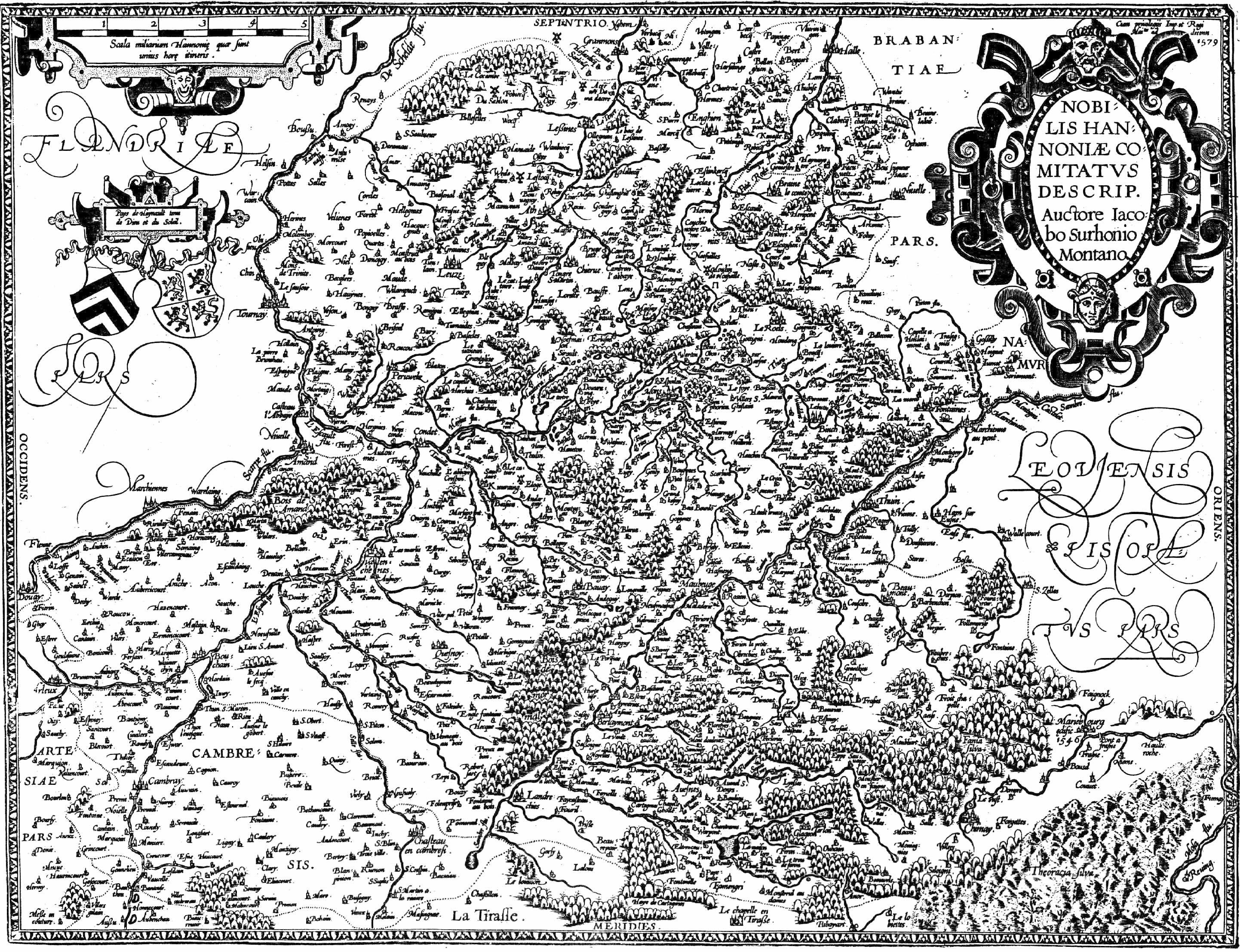
Nobilis Hannoniae Comitatus Descrip. Auctore Iacobo Surhonio Montano
Pays de Haynault tenu de Dieu et du Soleil.
Cum privilegijs Imp. et Regi Maitis ad decenn. 1579 (1)
The central role which the county of Hainaut played in the medieval history of Europe is generally not so well known. However, between the 10th and the 15th centuries, Counts of Hainaut acted as independent heads of states, on a par with the kings of France and England; although they were nominally vassals of the Holy Roman Empire, they maintained close ties with their neighbours and cousins, the Counts of Flanders (2) (nominally vassals of the King of France) and with the royal families in France and in England At the time of the crusades, one Count Baudouin became Emperor of Constantinople. Eventually, in 1436, Countess Jacqueline de Bavière relinquished the sovereignty of her County to Philippe le Bon, Duke of Burgundy; Hainaut thus lost its independence and became part of the states of Burgundy. In the 16th century, Hainaut was part of the possessions of Charles V, King of Spain and Holy Roman Emperor.
Map of Haynault by Jacques Surhon, 1579 (3859 Kb)
Cartography was an essential tool for Charles V; it helped him to have a comprehensive view of his empire which comprised the recently discovered New World and on which the sun never set; his piloto mayor collected all reports from navigators and compiled the information on maps of strategic importance.
In 1548, Charles V commissioned Jacques Surhon to establish a map of Hainaut; in 1549, three copies of the manuscript map were delivered to him, to the Governor of the Low Countries and to the Grand Bailli de Hainaut (3). Surhon, who was born in the area of Bavay, was established as a goldsmith in Mons, before he turned cartographer and mathematicus for the Emperor. He had to keep his map secret, as well as all the topographical ground work, and was forbidden to make other copies; Hainaut was a critical area, being a territory on the French border, subject to harsh religious fights between Protestants and Catholics.
In 1570, when Abraham Ortelius published his first Theatrum Orbis Terrarum, Hainaut was not included. He tried to include Surhon's map in his 1572 edition and even had it engraved by Frans Hogenberg (a few copies have been printed (4), which are now praised collector's items); however he did not receive the authorisation from the Grand Bailli. It is only in the 1579's edition of Ortelius atlas, that the map was officially published (as reproduced overleaf): the seditious Protestants in Valenciennes and Mons had then been crushed by the Spanish repression (and the Huguenots had been massacred in France); the map was no longer so strategically critical.
The copper plate was modified for the 1579 edition (5), with the contribution of Jean Surhon, the son of Jacques (who had died in 1557) and author of maps of the County of Namur, of Picardie and Vermandois.
This map of Hainaut served as model for many cartographers well into the 17th century, notably for Mercator and for the 1613 re-edition of Guicciardini's Description de tous les Pays-Bas (6).
Comments on the area depicted:
The County of Hainaut shown on this 16th century map is quite different from today's Belgian Province.
The County then comprised territories which were conquered by Louis XIV during the second half of the 17th century (Valenciennes, Maubeuge, Avesnes, Le Quesnoy...) and are now in France; it also comprised the Flemish speaking area around Halle (now in Brabant). On the other hand, it did not comprise the area where Charleroi was founded in the 17th century (then with the County of Namur) which now belongs to the Province of Hainaut.
The map also shows Cambresis, which belonged to the bishop of Cambray, separated from the County of Hainaut by a dotted line (in more detail than in the subsequent edition of 1579 which was more widely used in Ortelius atlases (7).
It can be noted that the south-east boundary, with Namur, is not shown; the area includes Marieburg, a stronghold founded by Marie de Hongrie in 1546 (as indicated on the map) to guard the border with France but taken by the French in 1554.
by Jean-Louis Renteux
More about maps of Hainaut
An overview of their evolution, from ancient times until the 19th century, is given in Cartes anciennes du Hainaut; this 10 pages article by Jean-Louis Renteux is part of the book Le Haynault de nos ancêtres published in December 2003 by the Association Généalogique Flandre-Hainaut, in Valenciennes, on the occasion of its twentieth anniversary (152 pp. in full colour, with many articles on the history of Hainaut, nicely illustrated, 21 x 29.6 cm, colour jacket illustrated with a colour map of Hainaut - ISSN 09762-6673) (8).
A comprehensive list of maps of Hainaut (and Brabant) until the mid-19th century can be found in the work of Johan Vanvolsem, Naamvorming & naamverspreiding van Halle door de eeuwen heen (which was reviewed in BIMCC Newsletter No 8, September 2000).
(1) Plate 70 in Marcel van den Broecke Ortelius Atlas Maps - An illustrated guide.
(2) On several occasions the two Counties were held by the same heir.
(3) These maps have been lost.
(4) Perhaps about 100, according to Marcel van den Broecke Ortelius Atlas Maps - An illustrated guide.
(5) Notable differences between the 1572 and 1579 versions include:
(6) The first edition, in 1567, included a simplified version.
(7) Plate 71 in Marcel van den Broecke Ortelius Atlas Maps - An illustrated guide.
(8) Can be ordered from AGFH, BP 493, F-59321 Valenciennes Cedex - Price: EUR 30.00.