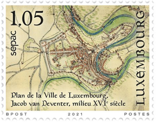
As part of the SEPAC organisation’s 2021 joint issue of stamps on the theme of Historical Maps, POST Philately is depicting the oldest, precise map of the city of Luxembourg drawn by Jacob van Deventer in the sixteenth century. He created this important document shortly after 1559 on the orders of King Philip II of Spain.
Read more.
Terrae Incognitae, the Journal of the Society for the History of Discoveries, aims to examine the history and impact of geographic exploration and cross-cultural interaction around the globe prior to the modern era. Some articles are freely available.
Volume 53, 2021 has been recently issued.
It contains a fascinating article, by Paolo Chiesa, entitled Marckalada: The First Mention of America in the Mediterranean Area (c. 1340), examines discussions about Markland, a geographic region scholars today consider to be part of the Atlantic coast of America. As the title of the article indicates, Chiesa suggests that geographic knowledge about Markland circulated in the Mediterranean region during the first half of the fourteenth century, well before the time of Columbus.
Link to the full article: https://www.tandfonline.com/doi/full/10.1080/00822884.2021.1943792
La Carte d’Avignon : De la Méditerranée à la Baltique 1190 – 1490 [The Avignon Chart: From the Mediterranean to the Baltic 1190 – 1490] by Jacques Mille (Nicola Boothby)
Atlas wilde bomen en struiken - Landschappelijk groen erfgoed in de provincies van Nederland en Vlaanderen [Atlas of Wild Trees and Shrubs – Scenic Green Heritage in the Provinces of the Netherlands and Flanders]
Catalan Maps and Jewish Books: The Intellectual Profile of Elisha ben Abraham Cresques (1325-1387)
History and Cartography
What Dick Pflederer’s Census tells us about portolan charts
The proceedings of the postponed symposium Mapping the Ottoman Realm: Travelers, Cartographers and Archaeologists (which was due to take place in Istanbul in April 2020 before the pandemic intervened), have been published in an open access volume which can be found here. The volume also contains a preface by the commission chair Imre Demhardt, with the full story on the course the symposium took from spring 2020 to the summer of 2021.
The proceedings contain a paper by Wouter Bracke, President of the Brussels Map Circle, entitled From the Atlas de l’Europe by Philippe Vandermaelen (1828–1833) to the Weiss Map by Thomas Best Jervis (1854).
The Vinland Map, which purports to be a fifteenth-century map with a pre-Columbian depiction of the North American Coast, was drawn with modern inks, suggests a new analysis by Yale scientists and conservators.
Read more on YaleNews.
As the 38th European Heritage Days are held on 18 and 19 September 2021, IGN France website presents some of the most emblematic jewels in the world history of cartography.
From the first representations on clay tablets to the digital age, IGN offers a look at thirty centuries of maps and appreciate the legacy of genius cartographers who, at the crossroads of the arts, sciences and spirituality, drew maps that reflected their perception of the world. (free version)
The cartographic representations developed by civilisations evolve with their own techniques and aesthetic sense. The thirty examples that illustrate this historical journey seem to be characteristic of particularly remarkable cultures with an undeniable influence in the spiritual, artistic and technical development of humanity. It is also an invitation to discover other maps, treasures that are both art and science, such as those of the IGN France presented at the end of this panorama.
Read more.
This issue includes Emily Boak’s 2020 Ristow prize-winning essay on the British mapping of Afghanistan, Matthew Edney’s article on Joachim Lelewel’s editing early maps, Wesley A. Brown’s favorite map that engages James W. Abert’s exploration of the southwestern United States, Dirk de Pagter’s journey of maps by Don Juan Corradi, Donald McGuirk’s discussion of Giovanni Vavassore’s Tuto il Mondi Tereno (c. 1522), Ira Lourie’s inquiry about A.J. Johnson’s maps, and four book reviews.
Read more.
The archives of the de Bersacques family are unique and are kept in the State Archives in Kortrijk (Belgium). Several members of this family were surveyors from the second half of the sixteenth century until the first half of the eighteenth century. This archive contains measurement reports, plans, figurative maps, etc. of the southern part of West Flanders. There are also a few documents concerning East Flanders, Hainaut and northern France.
The best-known member of the family is undoubtedly the surveyor-topographer Louis de Bersacques (ca 1586-1646). As a sworn surveyor of the Kortrijk châtellenie, he acquired a monopoly on the mapping of this region.
In this family archive, we find numerous measurement reports, but also a few sketches and a pen-and-ink drawing, the final version of which is often unknown.
This collection, which comprises almost five linear metres and 1 610 archival documents from the years 1578-1744, has been fully digitised by the State Archives and is available for consultation online.
These documents mainly concern the southern part of West Flanders (Kortrijk, Bellegem, Wevelgem, Moorsele, Dadizele, Rekkem, Menin, Marke, Rollegem, Waregem, Langemark, Lauwe, etc.). There are also a few documents concerning East Flanders (Beveren), Hainaut (Tournai, Mouscron, Dottignies) and northern France (Tourcoing).
It should be noted that the Hainaut towns are noted in Dutch (e.g. Tournai => Doornik). The search in the inventory must therefore be carried out using Dutch terms.
The State Archives in Arlon have also a series of forest maps dating from the years 1618 and 1619 by Louis and Jean de Bersacques: ban and wood of Notre Dame in the Provostry of Orchimont, a wood of the gruerie of Virton, wood of Chesnel in the northwest of Marbehan, La Sarte on the River of Semois.
Read more.
Read more.
Let us mention the article of K. Solchenbach (University of Luxemburg, Institute for History) entitled Comparing old maps with cartometric methods – A case study with Bayesian data analysis about the calculation of the planimetric accuracy of old maps; the test case concerns two old maps of the region between the Meuse and Rhine rivers, including the Grand-Duchy of Luxemburg and the greater region, with parts of Belgium, France and
Germany, i.e. The Luxemburg map of Gerhard Mercator, published in his atlas from 1585 on and The Luxemburg published in Ortelius’ Theatrum Orbis Terrarum from 1579 on.