Visages de l’exploration au XIXe siècle – Du mythe à l’histoire [Faces of exploration in the 19th century – From myth to history] - Map Circle Excursion to Paris on 2 July 2022
Looks at Books
Visages de l’exploration au XIXe siècle [Faces of exploration in the 19th century] - Catalogue of the Exhibition
Colonisation & Propagande [Colonisation and Propaganda]
Indonesia’s struggle for independence, which reached its climax in the 1940s, has long been regarded as a conflict between the colonial power, the Netherlands, and the colonized Dutch East Indies. But in fact it is part of world history. David Van Reybrouck’s Revolusi is the first book to go beyond the national perspective and demonstrate the conflict’s global significance.
Indonesia was the first country to declare independence after the Second World War. As soon as the Japanese occupation ended, young rebels engaged in armed resistance against any new form of domination. British, Australian and above all Dutch troops were sent to restore order and keep the peace, but instead their presence ignited the first modern war of decolonization. That struggle inspired independence movements in Asia, Africa and the Arab world, especially when Indonesia organized the legendary Bandung Conference in 1955, the first global conference without the West. The whole world had become involved with the Revolusi, and the whole world was changed by it.
In his familiar stirring and engaged style, and based on countless conversations with witnesses from different countries, David Van Reybrouck once again – after the phenomenal Congo. A History – presents a penetrating reconstruction of a struggle for independence.
Author: David Van Reybrouck, Revolusi, 2020, De Bezige Bij, 656 pp.
Source: Flanders Literature
The Portolan is the journal of the Washington Map Society; it furthers the purpose of the Society “to support and promote map collecting, cartography and the study of cartographic history.” The Portolan, the largest and most-widely distributed publication of its kind in the Americas, is issued three times per year, in the Spring/Summer, the Fall and Winter.
Read more.
A wink!
The Mare Nostrum Orchestra, conducted by Andrea De Carlo, performed at Caprarola Castle on 31 August 2022.
The programme included Moro per Amore, the eighth and last opera by Alessandro Stradella.
Many of our Members will remember our Excursion to the Academia Belgica in Rome in May 2016 and in particular our visit to Caprarola Castle.
Especially the Sala del Mappamondo, showing the whole of the known world as it was in 1574 when the frescoes were completed.
Read more:
In June 2021, ISHMap awarded the first Prize in Map History.
The projects for the winner and honorable mentions for the inaugural ISHMap Prize in Map History demonstrate exciting and innovative approaches to expanding the audiences for the history of maps and mapping through community engagement and interdisciplinary research. From traditional exhibitions with dynamic online content to physically bringing map history to local people in the countryside, these projects illustrate how vibrant and interdisciplinary map history can be.
You will find here descriptions of the Winner, Honorable Mentions and other notable submissions.
We remind you that Jan Trachet has been nominated for the 2021 ISHMap Prize in Map History with his Pourbus Troubadour project.
De Historische Atlas van het
Vlaams Gewest is inderdaad een
uniek kaartenboek. Sedert België
evolueerde naar een federale staat
en het Vlaams Gewest een realiteit
werd, was er geen echte atlas, die
het volledige gewest van De Panne
tot Maasmechelen en van Knokke
tot Ronse bestrijkt, voorhanden.
Wij willen met deze studie die
leemte opvullen met een werk dat
zowel de beroepshistoricus als de
geïnteresseerde liefhebber
aanspreekt. Wij geven graag toe dat
dit werk niet mogelijk zou geweest
zijn zonder het massaal online
plaatsen van allerhande oude en
mooie kaarten die tot dan toe in de
archieven verborgen bleven.
Dit werk is in de eerste plaats een
atlas, een verzameling van kaarten zoals die toen getekend en gegraveerd
werden. Sommige kaarten hebben wij bijgewerkt om hun leesbaarheid te
vergroten. Want leesbaarheid, is volgens onze bescheiden mening, een ‘conditio
sine qua non' voor het benaderen van een historische kaart.
De inhoud:
De Heraldische Kaart van het Brugse Vrije door Pieter Pourbus en gekopieerd
door Pieter Claeissens omstreeks 1601, op de kaart voorzien van nummers die
verwijzen naar de bijgevoegde legende.
De kaarten van het Amsterdamse huis Visscher, gekend onder de naam
Visscher-Roman kaarten uit 1656
De Fricx kaarten uit het begin van de 18de eeuw
De kaarten van J.P. de Bouge
De Kabinetskaart van Ferraris uit 1777, door de auteur voorzien van
parochiegrenzen, die niet op de originele kaartbladen stonden
De Carte Marchande van Ferraris uitgegeven in 1778
De topografische kaart van Vandermaelen op 1:80 000 uit het midden van
de 19de eeuw
Aangevuld met een hele reeks deelkaarten van kasselrijen, kwartieren,
departementen en provincies.
De auteur — Paul Vandewalle (°Brugge, 1941) studeerde geschiedenis aan de
Rijksuniversiteit te Gent en promoveerde in 1979 onder leiding van Prof. Dr.
Adriaan Verhulst tot Doctor in de Geschiedenis met als proefschrift De
geschiedenis van de landbouw in de Kasselrij Veurne, 1550-1645.
Beroepsmatig was hij leraar Geschiedenis aan het Sint-Lutgardis-instituut te
Oostende. Na zijn pensionnering ging zijn interesse steeds meer uit naar de
cartografie. Zo verscheen van zijn hand De Vlaamse Kasselrijen in kaart
gebracht en de tweedelige Historische Atlas van Veurne-Ambacht. Ook publiceerde hij een Historische Atlas van Knokke-Heist.
On 24 June 2022, Dr. Peter van der Krogt, editor of Brill book series Explokart Studies in the History of Cartography and Koeman Atlantes Neerlandici, and author of many more cartographic publications but also Member of the Brussels Map Circle, was presented with an Atlas Amicorum, on the occasion of his retirement as Jansonius curator of the collection of maps & atlases at Allard Pierson at the University of Amsterdam.
He was also rewarded with the Plancius medal and named officer in the Order of Orange Nassau for his work in putting cartography on the map around the world.
Wouter Bracke, President of the Brussels Map Circle, signs, with Maarten Bassens, a text entitled Koperplaatfragmenten van Gerard de Jode’s kaart van Hongarije (1567) in de Koninklijke Bibliotheek van België.
Paula van Gestel-Van het Schip is the Editor of the book.
Source: Brill website.
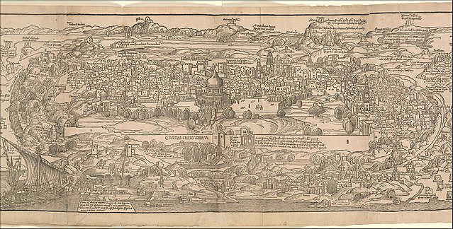
The Latin edition of Peregrinatio in terram sanctam (Speyer, 1490) in the Maurits Sabbe Library of KU Leuven (a Catholic research university in the city of Leuven, Belgium) has suffered severely from the ravages of time and less successful restoration attempts in the nineteenth century. A new intervention to conserve the valuable incunable is planned in 2022 with the support of the Adopt-a-book project of KU Leuven Libraries.
Peregrinatio in terram sanctam, book, Erhard Reuwich, detail (MET, 19.49.3). From Wikimedia Commons.
Read more.
A virtual exhibition accompanies this information.
 Peregrinatio in terram sanctam, book, Erhard Reuwich, detail (MET, 19.49.3). From Wikimedia Commons.