The article published on the Brussels Studies Web site presents the conclusions of a book published concomitantly by the Bibliothèque royale de Belgique: Philippe Vandermaelen, Mercator de la jeune Belgique. Histoire de l’Établissement géographique de Bruxelles et de son fondateur.
This publication is the result of twenty-five years of research in the Maps & Plans section, the depository of the exceptional cartographic and documentary collection from the Établissement géographique de Bruxelles. The article and work it refers to present the life of the visionary geographer in a chronological journey centred on his cartographic production (methodology, collaborations, surveys, levelling, commercial management, etc.), ending with a passing of the baton to the Dépôt de la Guerre, the future Institut géographique national. It also opens the doors to Vandermaelen's different institutional creations in a cross-cutting approach: the documentation centre, the natural history gallery, the lithography school and the École Normale, the museum of ethnography, and the organisation of scientific expeditions.
Read the article on http://brussels.revues.org/1438.
These leading Belgian auction houses have decided to
join forces and, thus, become the largest book auction in
Belgium and the Netherlands, specialising in rare, old,
and modern books, manuscripts, autographs, drawings,
prints, photographs and atlases and maps.
The two auction houses will merge gradually over the
course of 2017 and eventually move to a new, larger
location in Brussels. Johan Devroe and Henri Godts
will continue to build their expertise in concert with a
professional team of about a dozen employees.
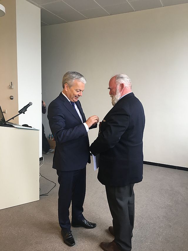
On 10 December 2016, Jan de Graeve, member of the Executive Committee of the Brussels Map Circle, received the Belgian Ordre de la Couronne / Kroonorde with rank of Officer from the hands of Didier Reynders, Belgian Minister of Foreign Affairs. The ceremony took place at the Royal Library of Belgium, during the Brussels Map Circle’s International Conference on Globes and Instruments, after Jan's lecture on Scientific measuring instruments in the 16th century. More details here.
"Jan de Graeve receiving the Belgian Ordre de la Couronne / Kroonorde with rank of Officer from the hands of Didier Reynders"
Issue 97 (Winter 2016), consisting of 84 pages, was published in November
2016 and is in distribution to all paid subscribers and members in good
standing of the Washington Map Society. Copies are available for purchase.
This thrice-yearly journal with articles on maps, the history of
cartography, and exploration is the only journal of its kind in the
Americas.
John Rennie Short explores the modern national atlas. Petra Svatek
discusses academic cartography at the University of Vienna from 1848-1900.
Harold Meinheit explores an 1838 map of Vietnam by Bishop Jean-Louis Taberd
being used in national disputes today over the Paracel Islands. Gunnar
Thompson proposes new information about the North Atlantic, and especially
Newfoundland. James Goode concludes a four-part series highlighting
treasures in the Albert H. Small Collection of Washingtoniana. Bert Johnson provides an early look at the coming July 2017 International Conference on
the History of Cartography.
Dr B. J. Vannieuwenhuyze (1980) has been named professor by special appointment of Historical Cartography at the University of Amsterdam (UvA)'s Faculty of Humanities, effective 1 September 2015. The chair was established on behalf of the Cartographiae Historicae Cathedra Foundation. A close partnership exists between the chair, the Explokart Foundation and the Special Collections division of the UvA's Library.
Bram Vannieuwenhuyze studied history at Ghent University, where he obtained his doctorate in 2008. He has worked as a postdoctoral assistant in Ghent and Leuven, and is currently a freelance historian in academic projects that mostly deal with historical cartography and urban history.
His inaugural speech was held on Friday 23 September 2016. Those who speak Dutch can watch the footage here.
Just published by Peeters Publishers in Louvain, Belgium in the Collection Turcica.
By Ségolène Débarre.
Year: 2016, ISBN: 978-90-429-3185-5, Pages: XVIII-406 p.
Summary:
Edward Said voyait dans l'orientalisme allemand un seul fantasme de cabinet: à rebours de cette conception, cet ouvrage montre qu'il se nourrit aussi d'expériences de terrain. Comment ? Il redessine la toile des producteurs - concepteurs, réalisateurs, traducteurs, commanditaires - des cartes de l'Asie mineure publiées à Berlin au XIXe siècle. Apparaît alors une géographie savante transnationale: de Péra à la Wilhelmstrasse, de Trébizonde à Leipzig, de Smyrne à Paris, Londres, Saint-Pétersbourg ou Vienne. Les producteurs autochtones et étrangers d'un savoir sur l'Empire ottoman circulent, se rencontrent et correspondent. La cartographie est au centre de l'attention des orientalistes savants, des hommes d'affaires et des militaires. C'est un sésame pour la philologie, l'archéologie, l'art de la guerre et le commerce. Entre 1835 et 1895, période que jalonnent les deux principales missions militaires envoyées par Berlin dans l'Empire ottoman, les intérêts stratégiques et académiques s'imbriquent et évoluent conjointement avec les projets militaires et civils ottomans. Rouage d'une histoire transimpériale, la cartographie de l'Asie mineure ne fut pas un simple vecteur d'un impérialisme allemand mais bien un outil au service de deux empires.
The new issue of e-Perimetron, the international web journal on
sciences and technologies affined to history of cartography and maps,
is now on-line:
http://www.e-perimetron.org
I. Vardakosta, S. Kapidakis (Athens / Corfu) Suggestions for Developing Geospatial Collections in Greek Academic Libraries;
E. Chodějovská, J. Pacina, J. Popelka (Prague / Ústí nad Labem) How to Understand the XVII-century-mappers? The I Military Survey of Bohemia Transformed into a Comprehensive Information System;
H. Dupont (Copenhagen) Denmark Seen from Above- A Crowdsourcing Project. Experiences with User Involvement. Experience with New Use of Aerial Photographs;
E. Arioti, G. Bitelli, G. Gatta (Bologna) Geomatic and Archival Sciences Applied to the Gregorian Cadastre of Bologna (Italy) for Analysis and Representation of the XIX Century Urban Arrangement
Our readers may remember the publications on Monaco by Rod Lyon, an active member of the Malta Map Society and formerly engaged as expert in ancient maps and engravings by a leading antiquarian dealer in Monte Carlo; after articles in our Newsletter No 37 (May 2010), he had produced a little book presenting the sum of his research over thirty-five years on maps of Monaco (see Newsletter No 48, January 2014).
A new edition of 'Monaco autrefois [Monaco in the past] – old maps, charts and plans of the Principality of Monaco (1640 – 1879)' has just been issued: hardback, 88 pp. fully illustrated in colour, with more maps and expanded texts.
Its larger format (A4) makes it an attractive book to view reproductions of all the maps in the book.
The book can be ordered (at EUR 50.00) from the author: Rod Lyon, 28 Triq is Sikka, Bahar-ic-Caghaq, Naxxar, Malta GC (28triqsikka@gmail.com).