Currently on display at the Librarium of the Royal Library of Belgium.
Take a look at the wonderful and impressive Atlas Maior, the final version of Joan Blaeu's atlas, and the largest and most expensive book published in the seventeenth century.
Free access.
A. C. Metcalf , S. M. Smith, Mapping the Maracanã Aqueduct: Reconstructing the Route of Rio de Janeiro’s Second Major Aqueduct
P. Buonora, The cartographic collection of the State Archive of Rome online. Archival issues and digital models
M. Piccardi, E. Pranzini, L. Rombai, Historical cartography and coastal dynamics of the Apuan littoral in the modern and contemporary periods: the port of Marina di Carrara (Tuscany, Italy)
A. Frolov, I. Konovalova, Reconstruction of the Black Sea Map in the Geographical Work of Abū al-Fidā'
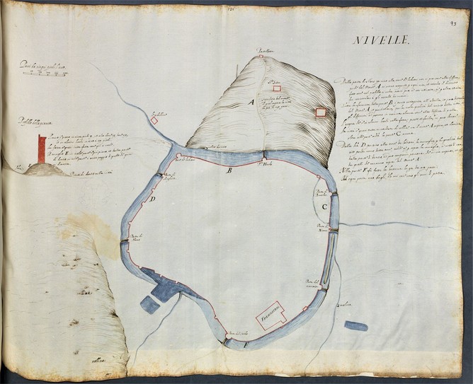
Plus qu’une carte, c’est un plan des fortifications de la Ville que le Musée communal a découvert, la plus ancienne représentation de la ville connue à ce jour. Le document est retranscrit dans l'atlas manuscrit Piante di fortezze d'Italia, d'Ungheria, di Fiandra e di Francia, actuellement conservé à la Bayerische Staatsbibliothek de Munich (Allemagne).
Piante di fortezze d'Italia, d'Ungheria, di Fiandra e di Francia - BSB Cod.icon. 141
[S.l.] Deutschland?, 1570/1580 - 1610
Le plan offre des informations précises sur les fortifications de la ville (onze tours, sept portes) ainsi que sur la toponymie et la topographie. Son importance est exceptionnelle pour l’histoire de l’entité, certains éléments qui y sont repris étaient inconnus.
Notons que l’intérieur de l’enceinte n’est pas représenté car il s’agissait d’un plan des défenses de la ville, plutôt à usage militaire.
Le Musée communal va continuer son travail de recherche afin de collecter un maximum de cartes et de documents, pour pouvoir montrer l’évolution de la ville.
Retrouvez la présentation scientifique de Sergio Boffa (PhD), Conservateur en chef du Musée communal dans le Polygraphe n° 3.
Source: https://nivelles.be/actu/article/745-decouverte-d-une-carte-de-nivelles-de-1575.html
See also: http://daten.digitale-sammlungen.de/~db/0001/bsb00019801/images/index.html?seite=190&fip=193.174.98.30
Malta Map Society Committee Members Joseph Schiro and Bernadine Scicluna have been invited by the Minister of Culture of the Czech Republic, Ph Dr. Ilja Smid, for the ceremonial handover of the certificates of Memory of the World International Register confirming the inscription of Giovanni Francesco Camocio's maps of the Great Siege of Malta of 1565 to the prestigious Memory of the World Register for the preservation of this exceptional documentary heritage.
The nomination of the Camocio maps was prepared as a transnational nomination from Malta and the Czech Republic through the cooperation of the Museum of Fine Arts in Valletta and Charles University in Prague.
The ceremony will be held on 5 April 2018 at 11.30 at the Nosticky Palace, Prague. Both parties will be delivering speeches during the ceremony.
The discovery in 2013 of State 2 of the Great Siege of Malta Map by Giovanni Francesco Camocio [fl. second half 16th century] at the Charles University Map Collection in Prague provided the unique opportunity for it to be linked with States 1, 3 and 4 found at the Cartographic Collection at the National Museum of Fine Arts, Valletta, Malta. This significant merge thus permanently sealed this four-state series of Great Siege maps. In their intact state, they collectively fill one of the many lacunae in the visual chronicle of the well-known Great Siege of Malta of 1565. Should one of the states be lost or damaged, the integrity of this series would be irreparably compromised. It cannot be emphasized enough that Great Siege maps are precious primary sources that act as the visual equivalent to written accounts of this battle, which determined the course of the history of the Mediterranean and Europe in the 16th century. In view of this, the virtual amalgamation of States 1, 3 and 4 with State 2 is effective in bringing together two overseas institutions sharing the common goal of educating and empowering the public.
Year of submission to the Memory of the World Register: 2016; year of inscription: 2017.
(sources: David Roderick Lyonand UNESCO)
The project will look at the transition from water to steam power in 19th century Scotland, very much using the Ordnance Survey's first and second edition maps to document locations and changing distributions of mills. The 3-year PhD is also supplemented by a six-month studentship project which will create a new, publicly-accessible web-based resource to ensure that the main results of the research are available widely.
Further details: https://www.findaphd.com/search/ProjectDetails.aspx?PJID=96163. Deadline for applications: Friday 6 April 2018
The project will be supervised by Dr Simon Naylor and Professor Paul Bishop, both at the University of Glasgow; Dr Miles Oglethorpe, Head of Industrial Heritage at HES is also co-supervising the project.
Funding is available to cover home tuition fees for UK or EU applicants for 3.5 years. A stipend is also available for students who have been resident in the UK for 3 years prior to the award (GBP 14 777.00 for Session 2018-19).
Chris Fleet. Map Curator | Collections and Research Department
National Library of Scotland, 159 Causewayside, Edinburgh EH9 1PH
Tel: +44 131 623 4670. Email: c.fleet@nls.uk. Website: maps.nls.uk
Maps have long been used to bring imaginary places to life, from Thomas More's Utopia to J.R.R. Tolkien's Middle Earth. But the role of the imagination in mapping extends well beyond the depiction of fantasy realms. This conference—co-organized by the Global History and Culture Centre at the University of Warwick and the History Department of Stanford University—is designed to showcase research and facilitate conversation about the role of the imagination in the cartographic enterprise writ large.
Presentations will ideally focus on a handful of particular maps, drawing chiefly on examples made between 1500 and 1900. Possible themes for exploration include:
Mapping utopias and dystopias
Projections of power and competing border claims
Recidivist cartography
Maps of alternative futures; maps of alternative pasts
Topographies of the unknown (uncharted territories)