Terra Brasilis (Nova Série) é uma publicação da Rede Brasileira de História da Geografia e Geografia Histórica, coletivo nacional de pesquisadores interessados na história da geografia, a geografia histórica, a história do pensamento geográfico, a história da cartografia e a história da geografia escolar, com ênfase no Brasil e na América Latina.
Read more.
The Man Who Mapped Siam: James McCarthy and the Royal Survey Department, by Hal Meinheit
Exercises of Imagination and Speculation: Mapping Northwest America in the Mid-Eighteenth Century, by Jacob Singer 2018 Ristow Honorable Mention
The First Map to Use the Name Toronto: Recently Discovered on a Three and a Half Century Old Map, by Rick Laprairie
Rising to the First – An interview with Dr. Paulette Hasier, by John Hessler
Recent publications -
This regular feature, a bibliographic listing of articles and books appearing worldwide on antique maps and globes and the history of cartography, is compiled by Leah M. Thomas.
Book reviews
Creating the Mediterranean: Maps and the Islamic Imagination (Reviewer: Dick Pflederer
Lost Maps of the Caliphs, Drawing the World in Eleventh Century Cairo (Reviewer: Cyrus Ala’i)
Philippine Cartography 1320-1899, Fourth Edition (Reviewer: Hal Meinheit)
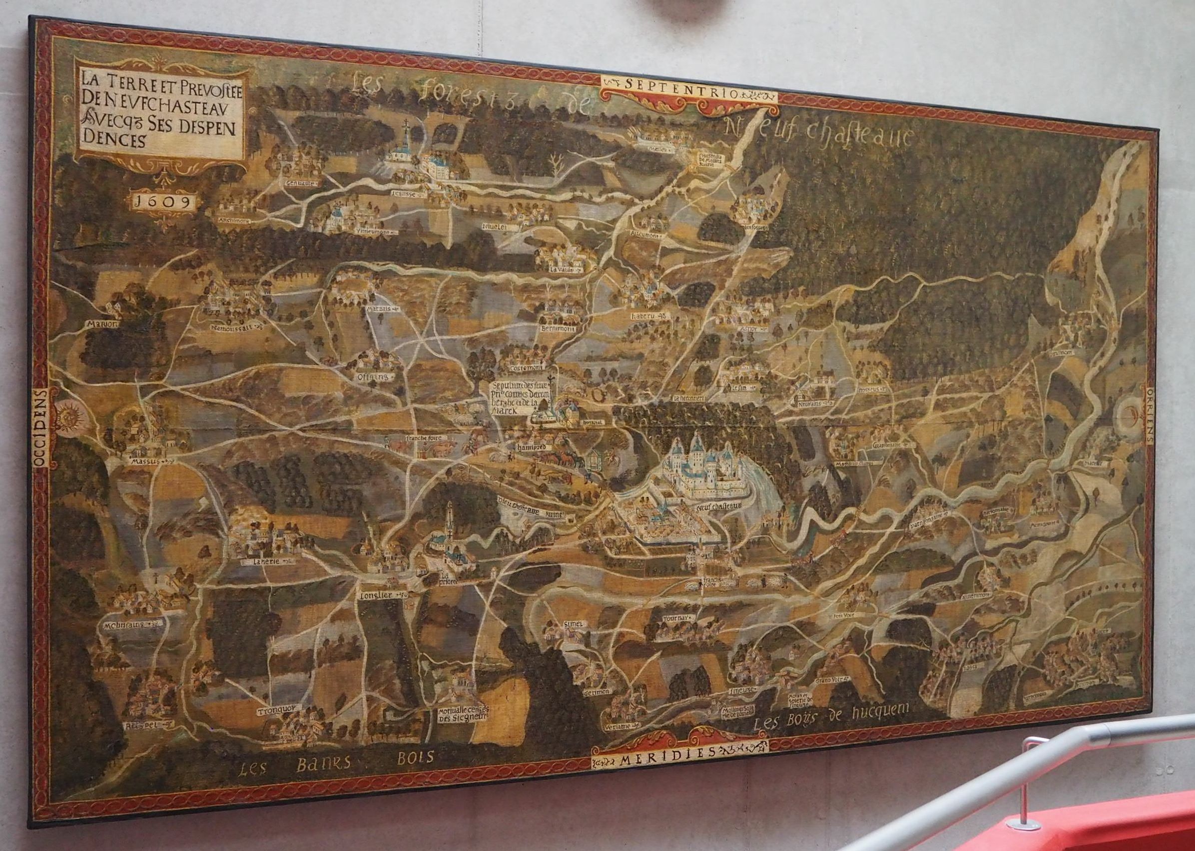
The State Archives of Belgium in Arlon recently took possession of their new building. On this occasion the map of La Terre et Prévôté de Neufchâteau avec ses dépendances in 1609 took place in the stairwell. This layout offers the curious a unique point of view to appreciate all the features of this map. It is an oil painting on canvas of 3.7 × 2.1 metres raised in 1609 at the initiative of Charles d'Arenberg (1550-1616).
Opening hours of the Archives: Tuesday to Friday and every first Saturday of the month except July and August from 9.00 to 16.30. The map is visible for free. Access to the archives is also free.
Map of La Terre et Prévôté de Neufchâteau avec ses dépendances en 1609
Read more on the Carte d'Arenberg de la Prévôté de Neufchâteau en 1609.
Other references: Hannick, Pierre, and Jean-Marie Duvosquel. La carte d'Arenberg de la terre et prévôté de Neufchâteau en 1609 (avec le ban de Mellier et la seigneurie de Bertrix), édition commentée en enrichie d'un dossier cartographique (18e-20e siècle). Bruxelles. Crédit communal, 1996.
As we are celebrating the 50th anniversary of the landing on the moon, the Royal Palace in Brussels is dedicating it's traditional summer exhibition to the moon.
Look at objects 21 and 22, showing two of the earliest maps of the moon. Interesting to note is that Apollo 11 landed in the so called Mare Tranquillitatis, named by the Italian astronomers Francesco Grimaldi and Giovanni Battista Riccioli in 1651. It was however Langrenus (Michael Florent van Langren, 1600-1675) who made the first map of the moon in 1645, naming the Mare Tranquillitatis … Mare Belgicum.
See also Luis Robles blog Historia y Mapas.
C. Fleet,
An open-source web-mapping toolkit for libraries, 59-76
Y. Z. Tzifopoulos, E. Livieratos,
Mapping Cartouches in Rigas' Charta and Gazis' Pinax: The Elaborately
Symbolic Narrative of a Map, 77-84
S. R. Svenningsen, M. L. Perner,
Using GIS and historical digitized aerial imagery and maps to analyze
information on Cold War Soviet military maps of Denmark, 85-96
C. Porter, K. Lilley, C. Lloyd, S. McDermott, R. Milligan,
Cartographic connections – the digital analysis and curation of
sixteenth-century maps of Great Britain and Ireland, 97-109
An exhibition at the Bibliothèque nationale de France. Title translated as Visions of the World for the same exhibition at the Louvre in Abu Dhabi in 2018.
Open daily except Mondays until 21 July 2019 at the BnF Bibliothèque François-Mitterrand, Quai François Mauriac, 75706 Paris Cedex 13. Full price entry ticket EUR 9.OO. A dynamic view of the exhibits, along with comments and videos in French, is available on http://expositions.bnf.fr/monde-en-spheres/index.html. The exhibition is accompanied by a descriptive and explanatory catalogue of 172 pages in French with 175 illustrations produced under the direction of Catherine Hofmann and François Nawrocki. ISBN/EAN: 978-2-7177-2798-2; BnF Editions distributed by Interforum. Price EUR 45.00. Available, among others, in the bookshop at the BnF.
For many diehard map collectors globes are not where it's at; too big or too small, too difficult to read, too inconvenient, or just simply decorations. Put three or four of them together, and we just give up.
But now Catherine Hoffman, head of maps and charts at the Bibliothèque Nationale de France (BnF) and François Nawrocki, assistant director of the Bibliothèque Saint-Geneviève, are making us think again.
The exhibition that is now running at the BnF in Paris until 21 July after first opening last year at the Louvre in Abu Dhabi, has achieved two very significant advances:
It has considerably expanded our understanding of the globe by placing a number of the most important of these (many from the collection of the BnF) in their contemporary environments. To go with the around 40 globes themselves – both celestial and terrestrial, and including armillary spheres and some strange artwork at the end – there are another 150 artefacts that answer the where, how and why questions, humanising each globe in the process.
Thus, for example, accompanying the Islamic globes we have star maps, an astrolabe and manuscript images of astronomers and astrologers at work. Similarly, in a large painting by Monsiau (1786), we see Louis XVI with a globe and chart very much in evidence, giving instructions to La Pérouse before his departure on his last voyage.
It has situated the globes in their philosophical, religious, astrological, historical and aesthetic contexts, effectively valorising them not just as concrete, graphic objects but as cultural syntheses of their times.
The most spectacular illustration of this must be the famous clip from Chaplin's film the Great Dictator – playing continuously at the exhibition – of Hynkel working out his megalomania with a large, gas filled world balloon while Wagner is playing in the background.
But it is of course the globes themselves that are the stars of the exhibition. The trip through time starts in the second century BCE in Greece with a beautiful six centimetres diameter, silver celestial globe
{Fig. 1}
and moves on through a group of medieval Arab and Iranian copper and bronze celestial globes (including perhaps the oldest one of all, made in Andalusia in the 11th century) to arrive in early renaissance Europe at what for the writer is the cartographic star of the exhibition. The BnF's full size facsimile of 1847 is a representation of the oldest surviving terrestrial globe, that of Martin Behaim dating from 1492. Although only a facsimile, it is far more accessible than the original and gives us a vivid impression of the splendid artefact that the original's 15th century owners would have seen.
There then follow, each in its historical and social context, important hand made, printed and even mechanical globes by Waldseemüller (the Green Globe of 1506), Scniepp (1575), Reinhold (1588), Hondius (1600), van Langren (1630) and many more through into the twentieth century.
There is also much of interest for those who still prefer a flat map to a globe, including several important world maps, gores, star charts and atlases, along with printed works on spheres and geography that marked their epoch, by Reisch (1504), Strabo (1516), Apian (1550), etc.
That globes and cartography have always been a real part of society is demonstrated in many graphic scenes depicted in the exhibition. Starting in the first century CE with a mosaic showing philosophers debating in the presence a globe, we then move on through Carolingian, Persian, Arabic, Indian and other decorative manuscripts showing scenes that include a globe or astronomical measuring devices. From the renaissance and beyond, the curators have chosen paintings (by Holbein the Younger, van der Neer, Lefebvre, Vermeer and many others) and even a tapestry that show the utilisation of globes and maps for commerce, war, scientific and astrological observation, and even for the education of the children of the rich.
If the writer had to select two preferences (not necessarily what he would like to take home with him) among all these remarkable objects on display, he would choose the splendid and very large armillary sphere that greets visitors as they enter the exhibition. Made sometime between 1709 and 1718 by Jérôme Martinot, Louis XIV's official clockmaker (horloger, a task that involved winding up all the royal clocks and watches), it was originally driven by a clockwork mechanism
{Fig. 2}
.
A second choice, and one definitely not to be taken home, would be the enormous (240 cm x 130 cm) globe prepared in 1788 by perhaps the most important French cartographer of the turn of the century, Edme Mentelle (1730-1815), as a teaching aid for the eldest son of Louis XVI
{Fig. 3}
. It is in fact three globes in one: a terrestrial globe on the outside which can be separated between the two poles to reveal a celestial globe on the inside and, the most surprising, another globe, the kernel, which is in fact the first ever relief globe of the world.
If, on the other hand, you do not share the writer's gigantomania, there is a wonderful selection of coins and medals from antiquity through to the renaissance, including one of the stars of the show, the beautiful eight centimetres diameter cameo called the Triumph of Lucinius
{Fig. 4}
; dating from the 4th century CE, it shows the emperor in his chariot crushing his enemies. Nothing new here perhaps, but in his hand he is carrying a globe representing the earth, while two figures are presenting him with both a solar and a lunar globe. Here, as with the coins and many of the sculptures and manuscripts, the possession of a globe, in the hand or under the feet, is the unmistakable sign of a ruler's power and dominance.
Finally, while you're at the exhibition, don't forget to pay your respects to the two massive and absolutely superb Coronelli globes that are permanently housed in the same building. These are the painted terrestrial and celestial globes of 1683 prepared for Louis XIV, four metres in diameter and weighing two tonnes apiece, that are permanently on display just a short distance from where you will be.
If one must find a flaw in the exhibition, then it is simply that it is a shame that, while the large explanatory panels are in both French and English, the cards that succinctly describe each item are only in French. Can it really be that onerous to translate these into English, and wouldn't it be worth it in order to transform a truly unique exhibition into a truly unique international exhibition?
The exhibition catalogue is both erudite and visually attractive, illustrating and explaining a large number of the exhibits and allowing the reader to gain a much deeper understanding of their historical and scientific backgrounds. High definition images are also to be found on the exhibition's excellent website (whose URL is given above).
Summing up, the exhibition is simply remarkable, giving a highly understandable overview of the representations of the earth and sky as a globe that has been over 2000 years in the making. There really is something here for everyone, to the extent that it is a tribute to the exhibition that it is impossible to satisfactorily translate its French title into English; neither Abu Dhabi's nor my own English translations adequately reflect the breadth, mystery and importance of the subjects covered.
By Andrew Cookson
The Board of Directors of Imago Mundi Ltd invites proposals for hosting the 2023 conference. Please see the links to the Guidelines for those organizing a future International Conference on the History of Cartography, http://www.maphistory.info/ichcintro.html. The Guidelines set out the requirements for a successful conference and are intended to assist potential hosts to prepare a strong case. In particular, please see the document, Hosting an international conference.
Those considering hosting the 2023 conference should contact the Chairman, Imago Mundi Ltd., Tony Campbell, 76 Ockendon Road, London Nl 3NW, UK, tony@tonycampbell.info, as soon as possible for further details. Formal proposals need to be submitted by 1 December 2019. It is hoped to announce the results in the spring of 2020.
Good wishes,
Tony Campbell
Source: message from Tony Campbell to the Brussels Map Circle
The Malta Map Society tenth anniversary celebrations will be held on November 16 and 17, 2019 at the Presidential Palace in Malta with a seminar and conference sponsored by the President of Malta H.E. Dr. George Vella. Dr. Vella was previously Minister for Foreign Affairs. He is an avid collector of antique maps and a member of the Malta Map Society.
Source: message from David Roderick Lyon to the Brussels Map Circle