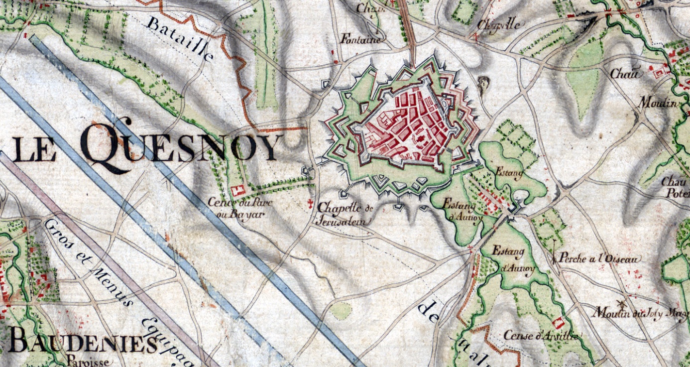
Parmi les trésors cartographiques conservés au Service historique de la Défense au Château de Vincennes se trouve une très grande carte manuscrite en couleur (160 × 143 cm environ). Cette carte signée « Naudin, ingénieur ordre du roy » a été dressée au moment de la bataille de Malplaquet (11 septembre 1709). C’est la première carte qui montre à grande échelle (1:28 800) le cœur du comté de Hainaut (région de Valenciennes, Mons, Landrecies, Avesnes) dont une bonne partie vient d’être conquise par la France : les villages ne sont plus représentés simplement par le symbole d’une église, mais par l’ensemble des rues, des maisons et des fermes qui les constituent ; la carte révèle la nature des paysages du Hainaut au début du XVIIIe siècle, avec, sans doute pour la première fois la représentation de « ouillères » dans le Borinage et dans la région de Fresnes.
Extrait de la Carte très particulière du Haynaut (…), cote 6 M LIB 903
Jean-Louis Renteux, le Vice-Président du Brussels Map Circle et éditeur de Maps in History, a analysé cette carte en détail dans un article paru dans le n° 238 de Cartes & Géomatique, bulletin du Comité Français de Cartographie (Décembre 2018). Il y étudie la situation militaire décrite sur la carte, avant, pendant et après la bataille de Malplaquet, bataille qui a marqué un tournant dans la guerre de Succession d’Espagne. Il examine également la carrière de Jean-Baptiste Naudin, ingénieur géographe au service du Ministre de la Guerre pendant cette même guerre, et les circonstances dans lesquelles il a dressé cette magnifique carte, puis l’a mise à jour pendant une vingtaine d’années. Cette carte a aussi certainement servi de source d’informations pour la production par le clan Naudin d’une série de cartes des régions frontalières jusqu’au milieu du XVIIIe siècle.
Le numéro 238 Cartes & Géomatique est en vente auprès du Secrétariat du Comité français de cartographie à l'adress suivante : 79, avenue de Paris, 94160 Saint-Mandé (tél/fax +33 1 43 74 70 93), Mél. lecfc@lecfc.fr, Web www.lecfc.fr.
The seventeenth Menno Hertzberger Prijs was awarded at the Koninklijke Bibliotheek on 21 March to prof.em.dr. Günter Schilder. The prize is for his entire oeuvre, but in particular for his standard work Early Dutch Maritime Cartography (2017). The Menno Hertzberger Aanmoedigingsprijs went to Dr. Arthur der Weduwen for his book Dutch and Flemish Newspapers of the Seventeenth Century, 1618-1700 (2017). The prizes are under the auspices of the Nederlandsche Vereeniging van Antiquaren, and reward studies in the field of book history.
Read more.
The world changes. The Royal Library of Belgium is evolving into KBR, a unique discovery experience to access exceptional knowledge.
Many sources of authentic information for readers and researchers
Rich cultural programming to discover extraordinary collections in a different way
Inspiring spaces: a real haven of peace dedicated to calm, study and reflection
Fully equipped meeting rooms in a unique setting, dedicated to professional meetings
KBR's missions remain the same, but the way to execute them changes. It adapts to society, rapidly changing, and to the new expectations of today's users.
KBR is now on a new website and has adopted a new logo.
All this is to be found on KBR website in French or in Dutch. Read more.
Jacopo de' Barbari and the Limits of Knowledge, by Rheagan Eric Martin,
Winning Article Ristow Prize 2018
The Lost Early Maps of Georgetown, by Chas Langelan
Brands and Nineteenth Century Antique Miniature Atlases, by Roger Stewart
Louis Max Nell – Colorado MapMaker, by Wesley Brown
ICHC28 – Amsterdam Update, by Bert Johnson
Recent publications - This regular feature, a bibliographic listing of articles and books appearing worldwide on antique
maps and globes and the history of cartography, is compiled by Leah M. Thomas.
Book reviews
A History of America in 100 Maps (Reviewer: JC McElveen)
Christianity Beyond Christendom: The Global Christian Experience on Medieval
Mappaemundi and Early Modern World Maps (Reviewer: Marguerite Ragnow)
The Da Vinci Globe (Reviewer: Bob Karrow)
Map Men: Transnational Lives and Deaths of Geographers in
the Making of East Central Europe (Reviewer: Wes Reisser)
The Stornoway map is one of a group belonging to Stornoway Public Library, which were sent to the National Library of Scotland (NLS) in 2017 for digitisation. However, the map could not initially be digitised due to its poor condition. It had been heavily conserved in the past, leaving the paper stained, skinned and distorted, with many large cracks, tears and losses. It had also been entirely covered in cellulose acetate lamination, making its surface very glossy. With funding from the Aurelius Trust, the NLS was able to undertake the conservation work necessary for digitisation, and the conservation project began in September 2018.
More interesting technical details about this project on
https://blog.nls.uk/conserving-the-map-of-stornoway-by-james-chapman-ca-1800/
.
Une carte du pays d’Alost, conservée aux Archives générales du Royaume (Belgique) et vieille de près de quatre siècles, a été restaurée. Cette grande carte murale (127 x 160,5 cm) relativement inconnue date de 1626 et est attribuée au cartographe Philips De Dijn, originaire d’Aspelare (Ninove). Le document est conservé au sein du fonds Arenberg.
La restauration avait été commandée par le cercle historique du pays d’Alost, qui voulait, à l’occasion de son 70e anniversaire, consacrer un numéro spécial de sa revue à ce trésor cartographique et à la figure de Philips De Dijn. La restauration a été soutenue par des subsides des pouvoirs publics flamands.
On ne sait exactement comment la carte est arrivée au sein du fonds Arenberg, conservé aux Archives générales du Royaume. La carte est orientée vers le sud et couvre le territoire de la châtellenie d’Alost (région entre l’Escaut et la Dendre). Elle contient des plans figuratifs des villes d’Alost, Grammont, Renaix et Zottegem ainsi que des plans de villes se situant en dehors du territoire, notamment Termonde, Gand, Lessines, Ninove et Audenarde. Les églises paroissiales, l’infrastructure routière, les cours d’eau, les forêts et les bâtiments importants se situant sur les frontières ou à leur proximité, sont également représentés. En dehors de la partie cartographiée, figure une construction architectonique avec cinq piliers, qui représentent cinq autres entités : les pays de Rode, Gavere, Zottegem, Boelare et Schorisse.
Source: http://www.arch.be/index.php?l=fr&m=actualites&r=toutes-les-actualites&a=2019-01-28-restauration-d-une-carte-murale-du-pays-d-alost
Een bijna vier eeuwen oude kaart van het Land van Aalst, bewaard in het Algemeen Rijksarchief (Belgïe), is dankzij een grondige restauratie in ere hersteld. Deze vooralsnog onbekende grote wandkaart (127 x 160,5 cm) dateert van 1626 en wordt toegeschreven aan de Aspelaarse cartograaf Philips De Dijn.
De opdracht tot restauratie werd gegeven door de Geschiedkundige Vereniging Het Land van Aalst, die naar aanleiding van haar 70e verjaardag in 2018 een jubileumnummer aan dit pronkstuk en aan de figuur van Philips De Dijn heeft gewijd. De restauratie was mogelijk dankzij projectsubsidies van de Vlaamse Overheid.
Waarom de kaart in het Arenbergarchief (Algemeen Rijksarchief) terechtkwam, is onduidelijk. De kaart is op het zuiden georiënteerd en beslaat het gebied van de kasselrij Land van Aalst (regio tussen Schelde en Dender). Op de kaart zijn figuratieve stadsplattegronden van Aalst, Geraardsbergen, Ronse en Zottegem te vinden, maar ook plattegronden van buiten het landsterritorium gelegen steden zoals Dendermonde, Gent, Lessen, Ninove en Oudenaarde. De parochiekerken, wegeninfrastructuur, waterlopen, bossen en belangrijke gebouwen op of nabij de landsgrenzen zijn eveneens weergegeven. Buiten het gecarteerde deel valt meteen de architectonische constructie met vijf pilaren op, die staan voor de vijf baanderijen: de Landen van Rode, Gavere, Zottegem, Boelare en Schorisse.
Source: http://www.arch.be/index.php?l=nl&m=nieuws&r=alle-nieuwsberichten&a=2019-01-28-prachtige-wandkaart-van-het-land-van-aalst-gerestaureerd
The State Archives of Belgium holds a real treasure of cartographic materials, but handing out original maps and plans in the reading rooms bears the risk of deteriorating the state of conservation of these documents. Indeed, repeated unrolling and rolling-up of these maps and plans that are sometimes of considerable size has taken its toll on the documents, which called for a large-scale digitization campaign. In recent years, some 60 000 maps and plans were digitised. This number increases steadily. Roughly 44 000 of these digital images have been processed and are now available for research.
Source: http://www.arch.be/index.php?l=en&m=news&r=all-news&a=2018-10-30-41-000-maps-and-plans-accessible-in-the-digital-reading-rooms-of-the-state-archives
The restoration of the scale model of Rome started in October 2018.
This scale model was designed by the French architect Paul Bigot. Originally there were four models, but only two survive to this day: one at the Univerity of Caen, France (his working model) and one at the Art & History Museum in Brussels, Belgium.
The model — on scale 1:400 — measures 11 metres by 4 metres and shows Rome at the end of the 4th century CE.
The restoration started with a thorough cleaning. After this a scan has been made and the lighting, projection and sound brought back to life, together with integration of modern technology.
The restoration should be finished in September 2019. It is made possible with the help of the King Baudouin Foundation.
Read more on http://www.kmkg-mrah.be/rome.