This exhibition invites visitors on a journey to the frontiers of reality and fiction, exploring the links between cartography and the imagination. For while maps usually trace the contours of known lands, they also give shape to imaginary territories that extend, interpret or personalise the real world.URL: https://www.bnf.fr/fr/agenda/cartes-imaginaires
Embark on a daring voyage into the depths of human imagination at the Harvard Museum of Natural History’s new special exhibition, Sea Monsters: Wonders of Nature and Imagination. Featuring ancient mariners' maps, literature, works of art, and natural history specimens, this exhibit explores the allure of serpents, krakens, and other monsters of the deep. Peer into the minds of scholars from centuries past, study sea creatures whose real lives are often more astonishing than the fantastical beings we might have imagined. Dive into the ocean of human consciousness, where dreams and fears entwine with reality, offering profound insights into our world and ourselves. Join us in unraveling the mysteries of the deep sea and the human psyche, where sea monsters—both real and imagined—beckon us to explore the unknown.URL: https://www.hmnh.harvard.edu/sea-monsters
Organisation: Académie des sciences et la Royal Society, bibliothèques Mazarine et l’Institut de France
Conceived jointly by two of Europe's oldest scientific academies, this exhibition traces more than three centuries of debate, experiment and cooperation around a fundamental question: what is the exact shape of the Earth?
More information here.
Sea charts are indispensable on board ships. But how did the sea map come into being and why? The cartography exhibition De zee in kaart explores the history of sea charts with atlases and measuring instruments.Venue: Het ScheepvaartmuseumURL: https://www.hetscheepvaartmuseum.com/whats-on/exhibitions/ch[...]
In 1775, a collision of word-historical forces, driven by ocean-spanning empires, conflicts over trade and settlement, and new ideas about society and government, came together in the spark of the American Revolution. Yet although both the causes and the consequences of the Revolution were grand in scale, the war ignited in the tinderbox of a very specific local geography: Boston and the surrounding towns of Massachusetts. Why did it happen here? The revolutionary moment was as much about places as it was about people or ideas. In and around Boston, the tensions of Britain’s colonial empire had been rising for decades before the 1770s. The commercial geography of the city and its region, zones of friction between classes and communities, and contestations over the environment all helped to create the conditions that led to an era of revolutionary upheaval in Massachusetts. In the Leventhal Map & Education Center’s exhibition Terrains of Independence, maps will offer the entry point to a reconsideration of the Revolutionary War through the lens of locality and place.URL: https://www.leventhalmap.org/exhibitions/
How do maps contribute to a sense of national and cultural identity? During the first decades of the nineteenth century, China was in a moment of transition, grappling with its geopolitical status as both an ancient and modern nation-state. It was in this moment that two series of large-format maps, one terrestrial and one celestial, were printed in the city of Suzhou. These maps were presented in an extraordinary format, on eight vertical sheets printed in the style of rubbings. Even more strikingly, they were rendered in a rich Prussian blue coloring. The blue maps were more than just visually astonishing. They also captured Chinese ideas about the relationship between terrestrial and celestial space, and provide insight today into how Chinese scholars and artists conceptualized the world around them. This exhibition considers these two blue maps in the context of their production, consumption, and functionality, revealing them as unique objects in the global history of mapmaking.URL: https://www.mocanyc.org/event/heaven-earth-the-blue-maps-of-[...]
–
Barcelona,
SpainIn just over a century, the city and plains of Barcelona underwent spectacular urban growth that profoundly transformed their morphology and landscape. To manage all these spatial changes, the administration needed to produce maps: maps to design projects such as new urban plans, the expansion and improvement of the road network, water supply, the construction of a modern sewerage network and the creation of urban parks. A series of transformations for which the production of cartography became essential.
More information here.
The exhibit explores how cartography depicts the depths of the Earth, the ocean floor, weather systems – anything but the Earth's surface. More information here.
‘Maps in books’ is a temporary exhibition in the MAP - Curiosum exhibition hall and acts as an ‘opening precursor’ to the new MAP - Mercator experience museum in Sint-Niklaas. From the 15th century, maps appeared in atlases and travelogues, as evidence of discoveries or as instruments of power and governance. Regional maps recorded land boundaries and property. Military maps determined strategies in battles.
All information on the exhibition here.Venue: MAP (Sint-Niklaas)
Analyzing the visual language of maps. Lines are the foundation of the visual language of maps. For centuries, mapmakers have experimented with the placement, density, and purpose of lines like these to make maps seem simple and objective. These lines are never as straightforward as they seem. This exhibition follows lines on maps to their extremes. By exploring how maps use lines to make the world legible, the exhibition will bring you through examples of mapmakers and artists who have created, bent, and broken these linear rules. By following these lines, you will find maps to be more complex and more motley than they ever imagined!
All information here.Venue: The Newberry Library
Step into the shadows at Secret Maps, a major new exhibition revealing the stories hidden in some of history’s most mysterious maps.
Maps have always been more than just tools for navigation – in the hand of governments, groups and individuals, maps create and control knowledge. In Secret Maps, we trace the levels of power, coercion and secrecy that lie behind maps from the 14th century to the present day, and uncover the invisible forces that draw and distort the world around us.
More information on the exhibition page.Venue: British Library
–
Marseille,
FranceFrom the Moon to the Evening Star, from the constellation of the Great Bear to the rings of Saturn, the celestial vault and the stars that inhabit it are the subject of immense fascination.
The exhibition ‘Reading the Sky’ focuses on the understanding of the night sky in the Mediterranean, as seen from Earth. From the first records of the ancient Mesopotamian sky to the popularity of contemporary astrology, via medieval Arab-Muslim astronomy and the Galilean revolution, societies in the Mediterranean basin have looked to the stars to situate themselves in the cosmos and organise themselves on Earth. Knowledge and beliefs have circulated between the shores, forming a common culture of the sky that still nourishes our contemporary approach to the stars.
More information here.
MAP - Mercator is the completely renovated museum in the heart of Sint-Niklaas. It opens on 13 December with a stunner of an opening festival: exhibitions, creative and educational workshops, guided tours and quests, nocturnes and atmospheric entertainment. More information and programme on the museum webpage (in Dutch).
–
Sint-Niklaas,
BelgiumHow do artists today depict heaven and earth at a time of fiercely shifting borders on our globe?
Today, the maps of the world are being firmly rearranged. Our globe is experiencing exciting times and getting a new layout. How do artists currently view heaven and earth? Using the scientific imagination of cartographer Mercator as a compass, artists critically and imaginatively explore themes such as: the vertical gaze or axis mundi, projections and corrections, measurements and yardsticks, riches and dangers in the subsoil, the crucial role of water and oceans, traces of the celestial globe and the art of getting lost in order to finally find one's own place. In addition to numerous artists, several scientists are also involved, which translates into an in-depth fringe programme.
All information about the exhibition may be found here.Venue: MAP (Sint-Niklaas)
This exhibit explores how the British, Ottoman and American empires documented the human and non-human geography, resources, and landscapes of the Persian Gulf and Arabian Peninsula in the nineteenth and twentieth centuries. It features historical maps and artifacts from the collections of the Branner Earth Sciences Library and the David Rumsey Map Center alongside cartographic visualizations created by the OpenGulf research collective.
Featured materials include maps derived from a dataset collected from the British Gazetteer of the Persian Gulf, Arabia, and Oman created using QGIS, including the map of mentions of date palms displayed here. By placing these historical materials and contemporary analyses in conversation, we uncover a genealogy of geographical thinking alongside the power structures embedded in imperial and colonial record-keeping. This exhibit aims to illustrate and critically engage the breadth, depth, and nature of colonial and imperial knowledge production regarding the Persian Gulf and Arabian Peninsula, highlighting its varied expressions in texts, maps, and charts.
This exhibition is also available to view digitally.Venue: Mitchell Earth Sciences, Branner Earth Sciences Library & Map Collections
–
London,
UKThe exhibition presents a selection of the maps drawn by Ursula K. Le Guin for her books. Many of this maps have never been exhibited before. Le Guin’s maps offer journeys of consciousness beyond conventional cartography, from the archipelagos of Earthsea to the talismanic maps of Always Coming Home.
More information here.Venue: AA Gallery, 36 Bedford Square, WC1B 3ES
This small exhibition is devoted to the representation of Gaul and of Roman roads through ancient maps. It is organised by the Gallo-Roman Museum of Waudrez, located on the ancient road leading from Bavay to Cologne (Vodgoriacum on Peutinger’s table).
The accompanying catalogue is remarkable; it reproduces all maps in large size (35x27 cm) and provides QR codes to access high-resolution copies (25 EUR).URL: https://statioromana.org/index.php/news-2/
Global view maps show the Earth’s curved surface as if seen from space. Spheres of Influence, an exhibition curated by California Map Society Student Exhibition Contest winner Champ Turner, traces the evolving uses of this unique type of map.
The global view map emerged in the 1930s and rose to prominence during the turbulent events of the mid-20th century. Widely published in magazines and newspapers, these maps use persuasive visual language to interpret complex international conflicts for the general public. Their emergence coincided with the rise of long-distance air travel and a changing perception of global security. Introduced to a mass audience by cartographer Richard Edes Harrison and rapidly adopted by his contemporaries, the global view countered the prevailing sense of American isolation and challenged audiences to reconsider the relative proximity of international allies and adversaries.
Using the global view map has allowed cartographers to wield significant influence over the narrative of global conflicts throughout the twentieth century. In this exhibition, we invite you to examine how cartographers, publications, and governments used the global view to inform, persuade and subtly shape our sense of place in the world.
This exhibition is also available to view digitally.Venue: David Rumsey Map CenterURL: https://events.stanford.edu/event/spheres-of-influence-proje[...]
–
Cassis,
FrOur member Jacques Mille is the curator of an exhibition to mark the 400th anniversary of the birth of Jean Dominique Cassini. Admission is free and visitors receive a catalogue of the exhibition.Venue: Salles Voutées - Pl. Baragnon, 13260 CassisLanguage: Fr Contact: jacques.mille2@wanadoo.fr Time schedule: 10.00-18.00
In the wake of disaster, maps play many roles, shaping understanding of the event in the immediate aftermath, serving as visceral portrayals for those who were not there, and communicating both scale and extent of the tragedy. They gavanize support for rebuilding by showing new possible futures and can be used to memorialize the event, inscribing the memory over the landscape. Drawing upon sources from historical representations to contemporary satellite imagery, the maps in this exhibition explore various ways communities use maps to make sense of calamity and move forward from it.
The exhibition was curated by Stanford student Muhammad Dhafer, winner of the 2024 California Map Society student exhibition competition.
More information here.Venue: David Rumsey Map Center
Organisation: Archives Départementale de La Réunion
Le Département de La Réunion et la République des Seychelles partagent ensemble une tradition de coopération riche, spécialement en termes culturels. Cela s’exprime aussi bien au niveau artistique (échange de résidences), linguistique et musical (Festival Kréol) que patrimonial (formations, partage d’expertises).
L’accueil de l’exposition seychelloise « Les Seychelles : voyage dans l’histoire des cartes (1482-1830) » aux Archives départementales de La Réunion s’enracine dans cette tradition de coopération culturelle. Il s’agit de proposer au public réunionnais une plongée dans l’histoire commune indioocéanienne à partir d’une exposition présentée pour la première fois en novembre 2023 à Victoria, à la Galerie nationale, lors de la réouverture de celle-ci. L’exposition est portée par le ministère de la Pêche et de l’Économie bleue de la République des Seychelles, le commissariat en a été assuré par Richard Touboul.
L’exposition retrace à partir de reproductions de cartes allant du XVe siècle jusqu’à 1830 l’évolution de la cartographie, de la navigation dans l’océan Indien et par là-même de la connaissance de nos territoires. La période française seychelloise (1742-1815) est largement représentée ; plusieurs objets de navigation ponctuent le parcours et restituent les conditions techniques de navigation d’époque. Venue: 4, rue Marcel Pagnol 97490 Sainte Clotilde URL: https://www.departement974.fr/actualite/archives-departement[...]
–
Edinburgh,
ScotlandThrough personal stories, photography and memorabilia, this new exhibition charts the creation and use of maps during the Second World War.
Between 1939 and 1945, over 3,000 million maps were produced for the Allied, Soviet and German forces during the Second World War.
Originally used to navigate the jungles of south-east Asia or for devising an escape plan, the maps on display are now mementoes, kept alongside medals and photographs to say ‘I was there.’
From aerial photography to war diaries, and even a fashionable dress made from escape and evasion maps, the exhibition introduces us to a Prisoner of War, an RAF pilot, a Brigadier and an army chaplain through the maps they kept as a memory of their war service.
Mor information here.Venue: National War Museum
–
Athens,
GreeceThe General State Archives of Greece organises an exhibition of archival material dedicated on "Athens: the birth of a capital city", to celebrate the 190th anniversary of the transfer of the capital of the Greek state from the city of Nafplio to Athens, by Royal Decree of the 18th-30th September 1834.
The exhibition is structured in eight sections and it presents the new city of Athens in terms of its urban planning and layout, through a very rich archival material (maps,lithographs, sketches, scrapbooks, documents, etc.).Venue: General State Archives of Greece – Central ServiceURL: https://www.archivesportaleurope.net/blog/athens-the-birth-o[...]
Meet the expedition members of the Belgica. Some 125 years ago, they set off from Antwerp to the last blind spot on the world map: Antarctica. The expedition got stuck in the polar ice and made history as a result. Learn how the men managed to survive, who followed in their footsteps, and what Antarctica is like today.Venue: Museum Aan de Stroom - Hanzestedenplaats 1, 2000 AntwerpLanguage: DutchURL: https://mas.be/nl/pagina/naar-antarctica
The cartographic approach has accompanied changes in the teaching of geography, always present, its place has gradually been asserted within the University of Lyon.
Through the cartographic productions and collections of the various geographers who have succeeded one another in the different universities of Lyon, we invite you to follow 150 years of geographical analyses, sometimes local, sometimes distant, developed on the spot.Venue: Campus de la Manufacture des Tabacs, Bibliothèque de la Manufacture, Université Jean Moulin Lyon 3URL: https://ichc2024.univ-lyon3.fr/exposition-teaching-maps-sur-[...]
From the 18th century onwards, and especially during the 19th century, individual mobility underwent considerable development in Europe, characterized by the growing importance of tourism. These travel practices were accompanied by a renewed print production, the work of various actors with complementary objectives. Maps and guidebooks in particular, inseparable instruments of travel and its representation, underwent numerous changes, reflecting the techniques and cultures of their time.
The exhibition combines objects, archival documents, travel reports and commercial publications in a chronological and thematic approach that illustrates the evolution of practices and representations associated with mobility. Several scales are covered, from long continental journeys to short stays in the Lyon region and its surroundings, to tourist trips across France. The documents gathered come mainly from the heritage collections of the Diderot Library in Lyon and from the Michelin company, a major French player in cartographic and tourist publications. Guidebooks from major publishers (Hachette, Michelin, Baedeker) are presented alongside lesser-known works that illustrate a local conception of the areas to be visited.
Exhibition organized at the Denis Diderot Library, as part of the "International Conference on the History of Cartography" (ICHC) 2024.Venue: Bibliothèque Diderot de Lyon, ENS de Lyon, 5 parvis René Descartes, 69007 LyonURL: https://ichc2024.univ-lyon3.fr/exhibition-paper-trails-maps-[...]
–
Liège,
BelgiumThroughout his life, Gustave Ruhl (Verviers, 1856 - Hermalle-sous-Argenteau, 1929) never stopped studying and defending the architectural heritage of our regions. This lawyer, active in the Royal Commission for Monuments and Sites and several learned societies, devoted numerous historical works to the cities of Verviers and Liège.
On his death, he bequeathed a large part of his estate, his library and all his documentation to the University of Liège. The "Vision(s)" exhibition aims to reveal the wealth of this exceptional documentary collection through a selection of items (notes, sketches, plans, engravings, photographs, etc.) relating to the cities of Liège and Verviers. It is also a unique opportunity for the public to discover some of the models and relief plans made by Gustave Ruhl and the holographic version of the City of Liège around 1730, created by Prof. Pierre Hallot (DIVA laboratory).
This exhibition is the fruit of a partnership between the Musée Wittert, the ULiège Library and the DIVA laboratory, three entities of the Pôle muséal et culturel of the Université de Liège.Venue: Place du 20-Août, 7 4000 LiègeEntry fee: FreeURL: https://www.wittert.uliege.be/cms/c_19610333/fr/vision-s
The city of Lyon is vulnerable to a variety of events, whether sudden or long and undetectable, until they take hold and threaten. Most of these events have left behind only words, which are not enough to help us understand what happened, or how people dealt with it.
This history is sometimes represented on maps or by images that allow us to grasp its scale and particularities. From this point of view, maps came late, accompanying a vision that was increasingly informed by science.
This exhibition looks at the city from the point of view of its vulnerabilities, through documents that are rarely seen and even less shown, while today's cities are full of measures to ensure the utmost security.Venue: Archives municipales de Lyon, 1 place des archives, 69002 LyonURL: https://ichc2024.univ-lyon3.fr/exhibition-vulnerability-what[...]
On Thursday 27 June at 12:00, the exhibition Maps. Cartographic heritage in Seville from the fifteenth to the eigtheenth centuries, curated by Guillermo Curbera Costello, professor of Mathematical Analysis at the University of Seville, will open its doors in the Fundación Cajasol.
The exhibition shows a selected collection of maps and books with maps from the period from the end of the Middle Ages and the beginning of the Renaissance in the fifteenth century to the Enlightenment in the eighteenth century, from the Archivo de Indias, the Biblioteca Colombina and the University of Seville. It consists of 29 fabulous works, of which seven are incunabula (published until 1500), twelve were published in the sixteenth century and the remaining ten in the seventeenth and eighteenth centuries.Venue: Fundación Cajasol, C/Álvarez Quintero, SevillaURL: https://fundacioncajasol.com/mapas-patrimonio-cartografico-e[...]
What is the distant? Another world, a country, a piece of land or sea, a piece of the universe that is difficult - sometimes impossible - to reach and apprehend. A double distance is imposed with the distant, spatial and mental, physical and cultural. The distant is considered on different scales: on the scale of a region, a continent, the globe, the cosmos... Its perception evolves over time, according to the lifestyles, political projects and technical means of those who perceive it.
We will adopt a point of view: the distant seen from Europe and by Europeans since what we commonly call "the great discoveries" and the diffusion of printing in which Lyon played an essential role. The integration of America into the image of the world was indeed a turning point. From the end of the 15th century onwards, Europeans perceived themselves as the centre of the world, over which they gradually extended their economic, political and cultural influence. The appearance of planispheres on which Europe occupies a central place is the most obvious figurative translation of this. The aim is not to retrace the history of European exploration and domination of the world, but to show - in the literal sense of the term - how they represented distant spaces and the people they sheltered. The period chosen, from around 1450 to 1950, will allow us to address these questions over a long period of time and to underline the depth of historical constructions by questioning the critical dimension of these representations.
The exhibition will particularly highlight documents (cartographic and iconographic) and actors from Lyon in order to underline the place of the city in international information networks over the centuries.Venue: Bibliothèque Part-Dieu, 30 Boulevard Marius Vivier Merle, 69003 LyonURL: https://www.bm-lyon.fr/les-rendez-vous-des-bibliotheques-mun[...]
Organisation: Archives départementales et métropolitaines
The Archives départementales et métropolitaines invite you to follow the way in which the representation of space in these areas has evolved over time.
Maps have had to respond to different, increasingly varied and complex functions. However, certain demands can be observed at all periods, such as when it comes to developing land or fortifying places.
Lyon naturally occupies a special place in this respect: cities were the focus of political and military attention from a very early stage, and mapping issues were particularly important there.Venue: Archives du département du Rhône et de la métropole de Lyon, 34 rue Général Mouton-Duvernet, 69003 LyonURL: https://ichc2024.univ-lyon3.fr/exhibition-the-detail-and-the[...]
Organisation: Osher Map Library and Smith Center for Cartographic Education
Chromolithography was used in the nineteenth century to create full-color and realistic images of the world. In geography, the process was used especially for the scenic, the special, and the spectacular. This exhibition explains the printing process and explores some of its particular applications to maps and bird’s-eye viewsVenue: Osher Map Library and Smith Center for Cartographic EducationEntry fee: FreeURL: https://oshermaps.org/news
Organisation: Koninklijke Belgische Marine Academie, de geschied- en heemkundige kring De Plate en het VLIZ
This year marks the 300th anniversary of the creation of the General East India Company, better known as the Ostend Company.
A new company
This year marks the 300th anniversary of the creation of the General East India Company, better known as the Ostend Company. In August 1723, a considerable capital was raised in just a few days through the issue of shares, with prominent traders from Antwerp, Brussels, and Ghent subscribing. With the funds raised, ships were purchased and prepared in Ostend. Ostend, the outer port of Bruges, thus became the centre of overseas trade expansion for our region in the eighteenth century. Dozens of ships sailed from Ostend to India and China (Canton). Thanks to a number of niche products such as tea (accounting for over 50% of the European market), the Ostend Company became a major global player in the China trade in the 1720s.
Record profits lead to international pressure
The Company’s shareholders were rewarded with a net profit of approximately 150%, and the port and city of Ostend flourished like never before. The Austrian Netherlands as a whole also benefited from the revived maritime trade. Despite its great success, the Ostend Company had to cease its trading activities in 1731 under pressure from Britain, the Netherlands, and France.
Not just a footnote in history
For a long time, historians believed that the Ostend Company was an insignificant footnote in our history. Recent research, however, has shown that the Ostend Company played a much more important role in our maritime past. The success of the Ostend Company made both policymakers in Brussels and the commercial elites realise the importance of maritime trade for our prosperity. Starting in 1748 and keeping the spirit of the Ostend Company in mind, they committed to the maritime revival of our regions. By the end of the eighteenth century, Ostend became one of the most important European ports. The maritime expertise thus accumulated in Ostend played a crucial role in restarting and expanding the shipping activities in Antwerp after the reopening of the river Scheldt in 1795.
The importance of the Ostend Company for the Flemish seaports and Belgian history should not be underestimated. It was not only the first multinational enterprise in our regions, but also the precursor to our current commercial relationships with the Far East. In addition, the Ostend Company played an important innovative role in shipbuilding and logistics.
To commemorate this significant milestone in our maritime history, a series of events will be organised in Ostend throughout 2023 and 2024.
Venue: Stadsmuseum, Langestraat 69, 8400 OostendeURL: https://oostendsecompagnie.wordpress.com/english-version-300[...]
The exhibition is made in collaboration with the Dutch embassy in Hanoi to mark 50 years of bilateral relations between Vietnam and the Netherlands and more than 400 years of people to people contacts. Various kinds of maps were produced over the centuries. From nautical charts for navigation purposes to atlas maps. The maps reflect the changing political and geographical situation of the region. Most maps in this exhibition show a larger region than Vietnam. They give insight in the relation between Vietnam and the surrounding regions. In the course of time some of the maps and atlases that were published tend to be more comprehensive and detailed. This exhibition focusses on maps of Vietnam that are produced in the Netherlands and that are part of the cartographic collections of Leiden University Libraries.URL: https://webpresentations.universiteitleiden.nl/s/vietnam/pag[...]
Organisation: Collectivité de Corse, Direction du Patrimoine, Musée de la Corse
Cartografia, la Corse en cartes 1520-1900 brings together geography and history in a corpus of representations of the island and the Mediterranean drawn under the eye of the cosmographer, the politician, the military, the hydrographer...
The exhibition features a selection of old documents, maps and plans, books and atlases, as well as the people and techniques involved in cartography.
The diversity of the collections on display is illuminated by their shapes, materials and colours. The presentation brings together an anthology of images that testify to the interest in Corsica over several centuries.Venue: Musée de la CorseURL: https://www.museudiacorsica.corsica/fr/expositions/cartograf[...]
Antes del descubrimiento de América (1492) y la posterior toma de conciencia en Europa (en torno a 1503) de que esas tierras eran un nuevo continente y no parte de Asia, el mundo conocido «cabía» gráficamente en un único círculo o hemisferio. Así, tanto los mapamundis de los antiguos geógrafos griegos y romanos, como los posteriores de la Edad Media, solían tener forma de círculo. El primer mapa conocido que mostró América como un continente separado, publicado en 1507, fue también el primero en incluir un pequeño mapa en doble hemisferio a modo de diagrama explicativo de la nueva configuración del mundo
Desde entonces, los mapas en doble hemisferio, conocidos coloquialmente como «dos de oros» por su similitud con ese naipe de la baraja, han estado asociados a la imagen de la cartografía antigua, alcanzando sus máximas cotas de belleza estética durante los siglos XVII y XVIII, cuando se produjeron auténticas obras de arte grabadas en cobre para su posterior impresión.
El diseño en doble hemisferio se aplicó, no solo a la división entre occidente y oriente, sino también entre norte y sur y, en general, entre una región y su simétrica. Los mapas del cielo también adoptaron esa configuración. Esta exposición ofrece una selección de mapas en «dos de oros» pertenecientes a diversas épocas, realizados en diferentes estilos e incluso soportes, que esperamos sea de su agrado.Venue: C/ General Ibáñez de Ibero, 3. 28003 Madrid
E-mail: documentacionign@mitma.esTime schedule: Mo-Fr 9:00-14:00Entry fee: Free entry.Catalogue availability: YesURL: https://www.ign.es/web/ign/portal/ic-salas-expo-madrid-2023
De tentoonstelling Mapping Modernity - Moderniteit in kaart vertelt het verhaal van onze wereld in 250 kaarten. De geschiedenis van de moderne tijd is de geschiedenis van controle; over de natuur, over bevolkingen, over goederenstromen. De mens stelde zichzelf in het centrum van het universum en gebruikte kaarten om de gecompliceerde, ongrijpbare werkelijkheid te beheersen. Iedere kaart is een inkijkje in de gedachtegang van de opdrachtgevers, en de manieren waarop zij de wereld naar hun hand wilden zetten.
Venue: Design Museum Den BoschURL: https://designmuseum.nl/tentoonstelling/mapping-modernity/?u[...]
Organisation: Embajada de España en Colombia y @proyectobachue
El próximo sábado 6 de mayo a las 5:00p.m en el CFCE (@cfcecartagena - Centro de Formación de la Cooperación Española en Cartagena de Indias, Colombia) se inaugura la exposición "Entry fee: Free entry.URL: https://razoncartografica.com/2023/05/04/exposicion-terra-fi[...]
Pour la commémoration du bicentenaire du cadastre, en 2007, les Archives départementales de la Vendée ont participé à une exposition, organisée dans les salons de la préfecture, en partenariat avec la Direction générale des Impôts. A cette occasion, 16 feuilles ont été sélectionnées parmi la collection complète des plans cadastraux napoléoniens, conservée aux Archives départementales et consultable en ligne (faire une recherche sur le site en demandant "cadastre + nom de la commune" et consulter les inventaires). A travers ces 16 plans, présentés à nouveau ici et choisis comme autant de jalons de l’histoire du cadastre napoléonien, le visiteur peut relever les traces des calculs topographiques et des opérations de triangulation, préalables au levé des plans, ou se pencher sur les détails, souvent esthétiques, des édifices, des cours d’eau, des roses des vents ou des cartouches.
Cette exposition est l'occasion de découvrir – ou de redécouvrir – ces plans, réalisés dans la première moitié du XIXe siècle par les géomètres chargés de délimiter et de relever le territoire des communes vendéennes. Chacun d'eux constitue en outre un document unique, véritable photographie d’une commune à une date donnée, et source précieuse pour toute recherche historique sur les propriétés foncières. URL: https://www.archives.vendee.fr/Decouvrir/Expositions-virtuel[...]
–
(online) Princeton,
USARichard Talbert has prepared an online exhibition for Princeton University Libraries: Late Ottoman Turkey in Princeton's Forgotten Maps, 1883-1923.
It's origin lies in Prof. Talbert's interest in the historical mapping of ancient and medieval Asia Minor by Heinrich Klieppert, which were based on travels in the region by Klieppert and others. The exhibition continues with later German mapping of Asia Minor, including WWI operations map by the German general staff. The coda provides a freely accessible link to Prof. Talbert's explanatory essay on the collection and its significance.
Overall, it provides a great example of the kinds of work produced by German geographers at the height of their powers prior to WWI.URL: https://storymaps.arcgis.com/collections/3afc128a641e47eb90b[...]
A selection was taken from some six hundred maps and plans on Ukraine, which belong to the Bodel Nijenhuis Collection and the Steegh/Teunissen Collection of Leiden University Libraries. Thirty maps on the history of the second largest country in Europe will be presented in six paragraphs. Each starts with a number of maps, with corresponding captions, and finishes with a short commentary that hopefully sheds some light on the present war of Russia against Ukraine.
The authors of the exhibition are Martijn Storms and Harrie Teunissen.
Read more.
Everyone will make up their own mind about the usability of the website. But the quality and resolution of the images are excellent.URL: https://webpresentations.universiteitleiden.nl/s/borderlands[...]
Op 9 oktober 1623, 400 jaar geleden, werd Ferdinand Verbiest in Pittem geboren. Hij werd jezuïet en vertrok als missionaris naar China. De missie werd geconfronteerd met een grootse maar onbekende cultuur. De jezuïeten zochten in Chinese woorden en gebruiken aanknopingspunten om hun Blijde Boodschap te verkondigen. Zijn confraters Ricci en Schall von Bell waren hem op die weg al voorgegaan.
De keizer had een mandaat van de hemel. Observatie van de hemellichamen om een kalender op te stellen was daarom van uitzonderlijke betekenis. Verbiest kon voortbouwen op recente gegevens uit Europa en kon best opschieten met de intelligente keizer Kangxi. Hooggeplaatste mandarijnen voelden zich echter vaak gekrenkt en werkten Verbiest tegen.
Venue: Cultuurbibliotheek Stock-LaureynsLanguage: DutchURL: https://www.cultuurbibliotheek.be/deelnemen
Until 28 October 2023, the Landesbibliothek Oldenburg will be exhibiting representative maps and atlases from the Homann publishing house in Nuremberg. The publishing house founded by Johann Baptist Homann (1664-1724) in 1702 quickly developed into the most important producer of maps and atlases in the 18th and 19th centuries.Venue: Landesbibliothek OldenburgTime schedule: Mon - Fri 10.00- 19.00, Sat 9.00 - 12.00Entry fee: FreeURL: https://www.oldenburg-tourismus.de/veranstaltungen/kalender/[...]
Met ruim 300 000 kaarten en tekeningen en 400 atlassen en kaartenboeken beheert het Nationaal Archief de grootste kaartencollectie van Nederland. Een aanzienlijk deel van deze kaarten is met de hand getekend en dus uniek. De kaarten zijn allemaal gemaakt vanuit een bepaald perspectief en met een specifiek doel. Zoals het beheren van het duingebied en aanleggen van een nieuw wegennet. Sommige kaarten zijn ook ingezet als propagandamiddel en om land in te nemen en te controleren.
Aan de hand van de thema’s Op weg, Kaarten en kolonialisme en Maakbaar Nederland toont het Nationaal Archief in de tentoonstelling Op de kaart de ideeën en bedoelingen van opdrachtgevers en makers van kaarten.Venue: Prins Willem-Alexanderhof 20, 2595 BE, Den HaagURL: https://www.nationaalarchief.nl/beleven/tentoonstelling/op-d[...]
Open kaart – van atlas tot streetmap toont zeven eeuwen cartografie in Nederland én werpt een blik in de toekomst. De tentoonstelling laat een enorme diversiteit aan kaarten zien vanaf de 15de eeuw en deelt de verhalen die erachter schuilgaan. Venue: Oude Turfmarkt 127-129, 1012 GC AmsterdamLanguage: DutchURL: https://allardpierson.nl/bezoek/tentoonstellingen/open-kaart[...]
La primera circunnavegación del mundo, que se inició en 1519 y finalizó en 1522, es la mayor gesta exploradora de la historia, que puede ser comparable con hitos más actuales como la llegada a la Luna.
Esta exposición muestra un recorrido cartográfico aspectos interesantes del viaje: sus antecedentes, preparativos, desarrollo y consecuencias. Partiendo de los conceptos geográficos de los antiguos, pasaremos por el inesperado descubrimiento del continente americano, el tratado de Tordesillas por el que España y Portugal se repartían el mundo, el espionaje cartográfico entre las dos potencias ibéricas, el comercio de las especias como verdadero objetivo de la expedición o los primeros mapas del estrecho de Magallanes y de las islas Molucas, todo ello ambientado en la España del siglo XVI.Venue: Museo Casa de la Ciencia (CSIC), SevillaURL: https://fundaciondescubre.es/agenda/los-mapas-y-la-primera-v[...]
Organisation: Amis du Musée de Cassis et Mairie de Cassis
Présentation de cartes géographiques anciennes et de plans de Cassis et de Provence, du Moyen Âge au 20e siècle.
Presentation of old maps and plans of Cassis and Provence, from the Middle Ages to the twentieth century.Venue: Salles voûtées de Cassis, Mairie, Place Baragnon, Cassis Contact: Jacques Mille
E-mail: jacques.mille2@wanadoo.frTime schedule: 10.00-19.00Entry fee: Free entry.Catalogue availability: YesURL: https://centreculturelcassis.com/events/4147/
David Rumsey selected the maps in this exhibition for their high level of narrative detail and exceptional aesthetic qualities, and to represent a range of time periods and cartographic, surveying, and printmaking techniques.
Some of these maps can be seen online, on the exhibition website.Venue: David Rumsey Map CenterURL: https://exhibits.stanford.edu/seeingcities
Vor 200 Jahren wurde mit den ersten Erkundungsarbeiten auf den Höhenzügen zwischen Hannover und Göttingen eine epochemachende Messung begonnen: die Gauß’sche Gradmessung. Sie verband hier in Mitteleuropa erstmals die großen Vermessungsnetze im Norden (Dänemark) mit denen im Süden (Preußen) und legte den Grundstein zu einem gesamteuropäischen Triangulationsnetz.
Die Messungen standen unter der Leitung des berühmten Universalwissenschaftlers und Hofrats Carl Friedrich Gauß (1777–1855). Bis zum Abschluss der Messungen im Jahr 1844 wurden im früheren Königreich Hannover ca. 3000 Punkte für vermessungstechnische Anwendungen mit einer für damalige Verhältnisse sehr hohen Genauigkeit bestimmt.
1822 wurde von Gauß und seinen Mitarbeitern mit dem Fortschreiten der Messungen von Göttingen Richtung Norden auch das Celler Land berührt. Gauß bezog ab Mai 1822 für mehrere Wochen die Celler Ausspannwirtschaft Sandkrug. Die Winkelmessungen nahm er in den recht kleinen Laternen des Uhrturms des Residenzschlosses sowie des Dachreiterturms der Stadtkirche St. Marien vor. Seine Mitarbeiter besetzten entfernte Stationen, um ihm von dort mit dem neuentwickelten Heliotrop Lichtsignale zusenden, so vom ca. 27 km entfernten Brelinger Berg sowie vom ca. 28 km entfernten Falkenberg.
Die Ausstellung zeigt, wie die Vermessung des Königreichs Hannover erarbeitet wurde, beleuchtet aber auch das Leben und das weitere wissenschaftliche Wirken von Carl Friedrich Gauß.Venue: Bomann-Museum Celle, Schloßplatz 7, 29221 CelleURL: https://www.bomann-museum.de/Quicknavigation/Startseite/inde[...]
In 1561, the Liberty of Bruges, the largest and richest castellany in the county of Flanders, commissioned Pieter Pourbus to paint a map of its entire territory, including all the roads, watercourses, villages and towns. Ten years later, the artist-cartographer delivered his completed magnum opus to his patrons.
A new exhibition gives you the opportunity to make your acquaintance with The painted map of the Liberty of Bruges (1571). A work that straddles the boundary between art and cartography, Pourbus’ detailed map depicts the harbour landscape of Bruges at the end of the sixteenthth century in a unique manner. The work was made at a crucial turning-point in history, immediately prior to the start of the Eighty Years’ War and before later industrialisation would change the configuration of the coastal landscape forever. As a result, the Pourbus map is one of the last invaluable testimonies to the medieval landscape that once surrounded Bruges. At the same time, its skilled combination of scale, dimensions and details makes it a technical masterpiece of the very highest quality.
In the exhibition Pieter Pourbus. Master of Maps, the painted map occupies the central position, both literally and figuratively. With the aid of a number of remarkable landscape-archaeological finds and the use of magnifying glasses and digital screens, this unique map and the lost medieval landscape it depicts will be brought back to life. What did the countryside around Bruges look like at the end of the sixteenth century? And what remnants of that period can still be found today?Venue: Groeningemuseum (room 10), Dijver 12, BruggeURL: https://www.museabrugge.be/en/calendar/exhibitions/pieterpou[...]
Terwijl het ontstaan van de grenzen met Frankrijk en Nederland duidelijk is, kan men dat moeilijk zeggen over de oostelijke kant van België. Daar, tussen Maas en Rijn, was het in het Ancien Regime een wisselend landschap van kleine heerlijkheden. De Franse revolutionairen gingen er aansluitend met de grove borstel door. Wijselijk liet men het zo tijdens de restauratie van 1815. Enkel de naamgeving verwijst nog naar oude tijden.Venue: Bibliotheek De Kimpel, Eikenlaan 23, Bilzen
Telephone: +32 89 51 95 05
E-mail: jannie.nijssen@bilzen.be
La relación formal entre el dibujo de vistas y la cartografía se remonta, al menos, al siglo II, cuando Claudio Ptolomeo tituló el primer capítulo de su célebre Geographia: «¿En qué se diferencia la Geografía de la Corografía?». Según Ptolomeo, la Geografía representaba el conjunto, haciendo uso de las matemáticas para «observar la proporción y las distancias» y «el tamaño y forma del globo terrestre» mientras que la Corografía describía «incluso los detalles más pequeños, como puertos, villas, aldeas», cuidando la similitud del dibujo y siendo la tarea del pintor.
Esta exposición reúne una esmerada selección de vistas y planos de ciudades del mundo a lo largo de la historia, con el propósito que Georg Braun resumía en el prólogo de su monumental Civitates Orbis Terrarum a finales del siglo XVI: «¿Qué sería más agradable que, en la seguridad del hogar, sin miedo a los peligros, poder contemplar en estos libros la forma de toda la tierra en que habitamos, adornada con el esplendor de sus diversas regiones, ríos, ciudades y fortalezas?»Venue: Museo de Santa Cruz. Sala de exposiciones temporales C/ Cervantes, 3. 45001, ToledoURL: https://www.ign.es/web/ign/portal/ic-salas-exposiciones
Organisation: Beinecke Rare Book & Manuscript Library
This exhibition presents many of the most historically significant manuscript maps from the late medieval and early modern period from the Beinecke Library’s vast collection of maps. It is focused on portolan charts - large, colorful charts that showed the shoreline of the Mediterranean, and were used by sailors to navigate from port to port. These maps were crucial to the expansion of European trade in the fiftieth and sixteenth century. Yale University Library has one of the most significant map collections of this period and owns some unique items not found in any other collection. When the holdings previously in the Map Room in Sterling Memorial Library were consolidated with Beinecke Rare Book and Manuscript Library collections in 2018, it formed the largest single repository of portolan maps in North America.
This exhibition presents maps from several different historical groups and demonstrates how maps functioned to place people within a larger world context. While primarily focusing on European maps, it also includes Middle Eastern and Asian world maps to illustrate common elements and also highlight significant differences. In addition, the exhibition presents some map forgeries and how they were determined to be fakes using scientific and historic analysis.
The flat display cases on the ground floor of the historic Beinecke Rare Book & Manuscript Library enable us to show twelve large maps alongside one another to allow the viewer to make comparisons between maps made at various periods and times in the crucial years surrounding the discovery, from the European perspective, of the new world.Venue: Beinecke Rare Book and Manuscript Librarymap 121 Wall Street, New Haven, CT 06511Entry fee: Free entry.URL: https://beinecke.library.yale.edu/worldinmaps
Organisation: Museo Civico di Bari - Associazione Italiana di Cartografia antica Roberto Almagià
La rappresentazione cartografica e le vedute della Terra di Bari
Sarà inaugurata il 6 ottobre la mostra organizzata dalla Associazione Italiana di Cartografia antica Roberto Almagià.
La mostra, aperta dal 6 ottobre al 12 novembre 2022, presenterà un percorso di carte geografiche antiche e di vedute a partire dalle prime rappresentazioni a stampa fino alle piante della città relative ai piani regolatori e di sviluppo della fine del secolo scorso. Nella mostra saranno presentate opere di elevato spessore scientifico e rarità per il mondo collezionistico e per l’appassionato.
Le sezioni in cui sarà articolata la mostra racconteranno tra l’altro quale era la rappresentazione della città e della provincia, allora denominata Terra di Bari, con le prime vedute più realistiche delle città a partire dalla fine del ‘600 e fino allo sviluppo del porto nella storia.
Tra l’altro, oltre alla celebre veduta scenografica della città di Bari detta Bianchi-Dottula, verranno esposte alcune rarissime carte nautiche dell’Adriatico come quella del Barentsz e del Coronelli, e la carta generale dell’Adriatico manoscritta del Visconti (1810), mai esposta prima d’ora. Una chicca anche la carta topografica del porto di Bari della Marina statunitense, coeva del bombardamento del porto.
La cartografia del periodo borbonico (1650-1860) sarà largamente riportata, vista la sua importanza e l’altissimo livello topografico ed estetico che raggiunse.
Tra le particolarità che susciteranno l‘interesse del pubblico meno specialistico vi sarà il rapporto tra le vedute manoscritte della Biblioteca nazionale di Vienna e quelle a stampa del Pacichelli, di cui sarà possibile valutarne le origini.
Le vedute di costa del Porro, della Marina italiana post-unitaria, restituiranno una visione più familiare delle città pugliesi viste dal mare, anche se precedenti alle modifiche urbanistiche avvenute a partire dall’età umbertina.
Una sezione apposita sarà dedicata a strade e trasporti in Terra di Bari, comprensive anche dei movimenti della Guardia nazionale durante il brigantaggio e delle comunicazioni delle neonate Poste Italiane nel 1867.
La mostra quindi ambisce ad essere un momento di riappropriazione e rivalutazione di un passato su cui si innesta il nostro presente. Non solo ricostruzioni di tempi lontani ma un percorso che arriva vicino ai giorni nostri.
Terra di Bari è la nuova denominazione dell’Area metropolitana e riporta alle radici storiche del territorio, che è stato chiamato in questo modo sin dal Rinascimento. Dal passato bisogna partire per costruire il futuro.
La mostra sarà articolata in VII sezioni rappresentando la allora denominata “Terra di Bari”:
Desde tiempos remotos, una de las principales inquietudes del ser humano ha sido conocer cómo es el Mundo en el que habita, intentando responder a cuestiones como, ¿qué forma tiene la Tierra?, ¿cuáles son sus dimensiones? o ¿qué relación guarda con los cuerpos celestes?.
Esta exposición pretende mostrar una sucesión cronológica de documentos cartográficos que ilustran los cambios que, a lo largo de más de 2.500 años, ha tenido la imagen del Mundo.
Partiendo de las primeras referencias geográficas de la antigua Grecia, que consideraban un Mundo plano, pasaremos por la Tierra esférica propuesta por nombres destacados como Aristóteles y Eratóstenes, siguiendo por los mapas de «T en O» y las cartas náuticas de la Edad Media, el redescubrimiento de la Geographia de Ptolomeo en el Renacimiento, hasta llegar a las grandes exploraciones oceánicas que terminaron de delinear el Mundo tal y como lo conocemos hoy en día.Venue: Subdelegación del Gobierno en Guipúzcoa Plaza Pio XII, nº 6 20010 Donostia/San SebastiánURL: https://www.ign.es/web/ign/portal/ic-salas-exposiciones
Original antique engravings of churches, abbeys and monasteries in the Province of Brabant in the seventeenth century
The second edition of Anthonius Sanderus' Chorographia Sacra Brabantiae, published in 1726-1727 in The Hague, consists of three parts. Each volume contains some twenty engravings, detailed monochrome prints of abbeys, churches and monasteries in bird's eye view. The illustrations almost all cover a double page and measure approximately 35 × 48 cm.
Antoon Sanders (15 September 1586, Antwerp - 10 January 1664, Affligem), known by his Latinised name Anthonius Sanderus, was a Brabant poet, philosopher, canon, theologian and historian.
The author left us about forty works in Latin, of which the most famous is his Chorographia sacra Brabantiae sive celebrium in ea provincia ecclesiarum et coenobiorum descriptio, imaginibus aeneis illustrata, first published in Brussels in 1659 by Philippe Vleurgaert and a second time in The Hague in 1726 by Christian van Lom.
A chorograph, from the Ancient Greek χῶρος, chôros, land, place and from γραφία, graphía, writing, description, corresponds to a region-by-region description of the world, with the aim of representing the diversity of the earth. It is a regional geography of existing places, as opposed to a geography that focuses on a more global description of the earth.
The Chorography of Anthonius Sanderus describes the churches and monasteries of the then Spanish province of Brabant and illustrates them with copper engravings. This work was found in many abbey and castle libraries and the engravings are nowadays very much appreciated for their detailed depiction of completely or partially disappeared buildings. The Chorography is part of the spirit of the Counter-Reformation and the glorification of the Catholic Church under the protection of secular power.
To compile his work, Sanderus called on local informants, such as priests, abbots and other intellectuals, to whom he sent lists with questions about the history of the foundation of these ecclesiastical institutions, about miracles that had occurred, the presence of relics, and the specific hagiographies of each place. He researched the ecclesiastical dignitaries who had left their mark on the history of the places, collected topographical data and also information on the local fauna and flora.
The plates for this second edition were entrusted to engravers and were often based on the work of painters and illustrators. The engravers included Jean-Baptiste Berterham, Renier Blokhuysen, David Coster and Jacobus Harrewijn.
Text by Hélène Lecocq.
Given the size of the exhibition, this event will take place in two locations.Venue: Schleiper Art Gallery, Chaussée de Charleroi 149 and Rue de l'Étang 75, BrusselsURL: https://www.schleiper.com/gallery/exhibitions/3-chorographia[...]
El Instituto Geográfico Nacional acoge en Madrid, del 14 de septiembre al 14 de octubre, la exposición «Francisco Coello. 1822-2022. Pionero de la cartografía moderna», creada para dar a conocer la figura, obra y legado del geógrafo, cartógrafo e ingeniero militar jiennense Francisco Coello de Portugal y Quesada (1822-1898), protagonista de una decisiva renovación y modernización de la cartografía en combinación con la estadística en España en el siglo XIX, con motivo de la conmemoración del bicentenario de su nacimiento.
Impulsada conjuntamente por el Instituto de Estadística y Cartografía de Andalucía, la Fundación Centro de Estudios Andaluces, el Instituto Geográfico Nacional, la Dirección General del Catastro e Instituto Nacional de Estadística, la Diputación de Jaén e Instituto de Estudios Giennenses, el Ayuntamiento de Jaén, la Universidad de Jaén, la Escuela Politécnica Superior de Jaén y el Ilustre Colegio Oficial de Ingeniería Geomática y Topográfica, junto con la colaboración del Centro Geográfico del Ejército y la Real Sociedad Geográfica, la muestra, de orientación divulgativa y destinada al público general, propone un acercamiento a Francisco Coello y su labor cartográfica desde la óptica actual de la investigación y de la comunicación, a partir de tres secciones temáticas.
La primera, bajo el título Coello y su tiempo, presenta una aproximación a la vida y entorno familiar de Coello, junto con unas breves reseñas de la cartografía de España desarrollada durante la Edad Moderna y hasta los momentos en que el cartógrafo giennense acometería su prometedora renovación.
En el apartado titulado La cartografía de Coello se abordan, en segundo lugar, diversos aspectos de su formación como cartógrafo y, sobre todo, el panorama de sus abundantes producciones, de los materiales cartográficos de los que fue autor y responsable directo.
En una tercera sección, denominada Coello y la nueva cartografía, se contempla la importante actuación del cartógrafo desde puestos de responsabilidad en la Administración para la planificación e impulso de proyectos de envergadura como el Catastro y la construcción del mapa topográfico de España, actuaciones que serían el germen del posterior catastro y del Mapa Topográfico Nacional que constituye la base primaria de la cartografía española.Venue: Instituto Geográfico Nacional (Acceso por la Casa del Mapa), C/ General Ibáñez de Ibero, 3. 28003, MadridTime schedule: Monday-Friday 9.00-14.00URL: https://www.ign.es/web/ign/portal/ic-salas-exposiciones#coel[...]
Organisation: Stad Bilzen, Afdeling Vrije Tijd | Bibliotheek
Antonius Sanderus (°1586 - *1664) leefde als priester, theoloog en kanunnik in de tijd van reformatie en contrareformatie. Hij kreeg blijvende erkenning als cartograaf met de publicatie van twee monumentale werken: Flandria Illustrata (Het illustere Vlaanderen, 1641, een prentenboek over het graafschap Vlaanderen) en Chorographia Sacra Brabantiae (Gewijde plaatsbeschrijving van Brabant, 1659, over kloosters, abdijen en kerken).
Erik Van Hove geeft bezoekers persoonlijke uitleg over de expo op:
- woensdag 14 september om 20 uur
- zondag 18 september om 10.30 uur
Op zondag 9 oktober om 10.30 uur wordt de expo omkaderd met een boeiende lezing in de bibliotheek.
Lezing en geleide bezoeken zijn gratis. Inschrijven is verplicht via bibliotheek@bilzen.be of +32 89 51 95 06.
Hours of opening: see here.Venue: Bibliotheek De Kimpel, Eikenlaan 23, Bilzen
Telephone: +32 89 51 95 06
E-mail: jannie.nijssen@bilzen.beEntry fee: free entry.URL: https://www.uitinvlaanderen.be/agenda/e/geleid-bezoek-aan-de[...]
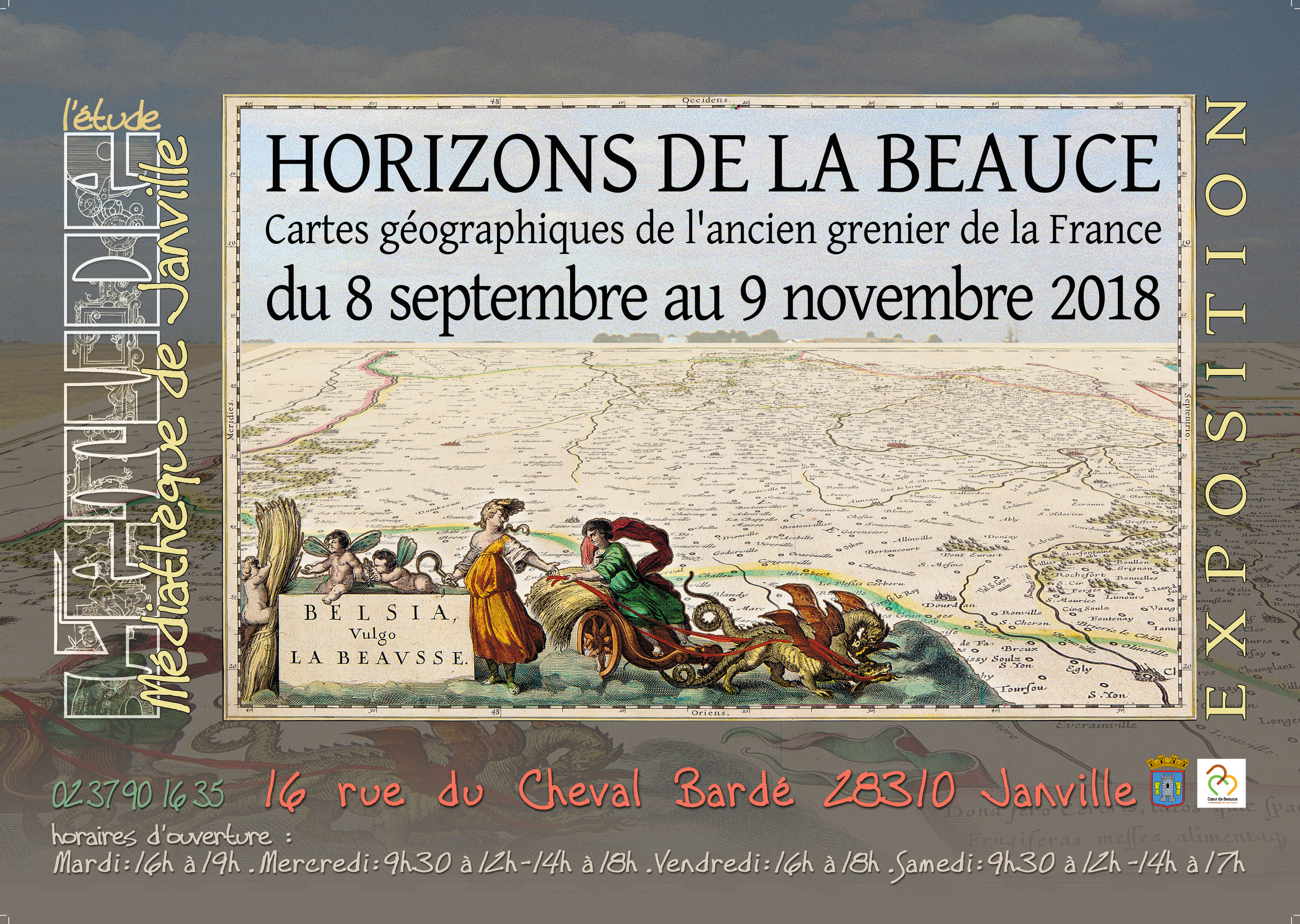
Dès l’Antiquité et probablement même avant de savoir écrire, les Hommes créent des cartes et des plans. Les premières cartes géographiques sont réalisées sur du papyrus et du parchemin.
La France est aujourd’hui un état unitaire décentralisé dont l’organisation territoriale repose sur trois échelons, — la commune, le département et la région —, auxquels s’ajoutent les structures intercommunales.
Vous découvrirez que l’expression millefeuille territorial, souvent utilisée pour dénoncer le trop grand nombre d’échelons administratifs, ne date pas d’hier.
Avec son exposition Par’chemins de Beauce, la Maison du Tourisme Cœur de Beauce retrace, de la Gaule à nos jours, les grandes évolutions administratives de la France.
Du 14 juillet au 25 septembre 2022, découvrez les provinces, les généralités, les départements et leur évolution mais également l’histoire de la cartographie à travers les cartographes célèbres et leurs réalisations.
De nombreuses cartes géographiques anciennes illustreront les panneaux didactiques.
See also the announcement
of the conference given by Wulf Bodenstein, Honorary President and Member of the Brussels Map Circle, on 23 September 2022 at the same location: Entry fee: EUR 2.00 to EUR 5.00URL: https://www.tourismecoeurdebeauce.fr/2022/07/08/parchemins-d[...]
Navigeren van 1500 tot vandaag.
There was a time when sailing the seas was the most adventurous thing one could do: the renaissance equivalent of being an astronaut.
Al in de prehistorie zoekt de mens zijn weg op het water. Tussen de eerste kustvaart en het gebruik van de moderne GPS ligt een zee van tijd en een route bezaaid met hindernissen. Maar voor elk probleem bedachten zeevaarders een creatieve oplossing. Tientallen navigatie-instrumenten, atlassen en kaarten illustreren de eeuwenlange zoektocht over oceanen. De expo brengt een mix van historische verhalen en exacte wetenschap. Via computeranimaties kom je meer te weten over de ambitie, ideeën en innovaties binnen de zeevaart en de ontmoeting tussen culturen die hieruit voortkwam. Filmopnames aan boord van een fregat en een patrouilleschip geven je zeebenen.
En je kan ook zelf aan de slag: bepaal je breedteligging met een sextant of neem het roer in handen in de vaarsimulator! Op verschillende momenten kan je zelfs gegidste rondleidingen krijgen van echte kandidaat-officieren van de zeevaartschool! Op deze interactieve expo worden voor het eerst zeldzame stukken uit private collecties getoond en zien we hoe Vlamingen een rol speelden in het creëren van nieuwe zeeroutes en het ontdekken van afgelegen gebieden. Met een extra aanbod op kindermaat leren zelfs de allerkleinsten over de ontdekkingen van Christoffel Columbus, Vasco da Gama en Ferdinand Magellan.
Ga mee op avontuur en bereid je voor op een ontdekkingstocht naar nieuwe werelden, smaken en mensen op maar liefst drie verschillende locaties.Venue: Tentoonstellingszaal Zwijgershoek, Mercatormuseum en Piet Elshoutzaal.URL: https://www.museasintniklaas.be/tentoonstellingen/recht-door[...]
La BnF célèbre le bicentenaire de la Société de géographie, dont elle conserve les archives, en consacrant une exposition à l’exploration au XIXe siècle. S’appuyant sur le fonds exceptionnel de la Société de géographie et sur d’importants prêts extérieurs, elle réunit près de 200 pièces qui permettent d’offrir un nouveau regard sur la curiosité savante, les « découvertes » de l’époque et plus largement l’entreprise exploratoire elle-même.Venue: BnF I François-Mitterrand Quai François-Mauriac - 75013 Paris (Entrée Est)Language: FrenchTime schedule: Tuesday-Saturday 10.00 -19.00; Sunday 13.00-19.00Entry fee: EUR 9.00Catalogue availability: YesURL: https://www.bnf.fr/fr/agenda/visages-de-lexploration-au-xixe[...]
Crossings invites you to take four historic routes across the United States.
Maps, guidebooks, travelogues, postcards, and more from the Newberry’s collection recreate travelers’ experiences along the northern and southern borders of the US, across the continent’s interior, and up and down the Mississippi River.
These cross-country paths have been in use for centuries whether by water, railroad, car, or airplane. And they’ve remained remarkably consistent despite changes in transportation, commerce, and the people who’ve used them.
But not everyone has experienced travel and mobility equally. The same paths meant “discovery” to the European explorer, freedom to the enslaved, and loss and removal for Indigenous nations.
Crossings shows how centuries of movement––from the Lewis and Clark expedition to the American road trip––have forged deep relationships between people and places that survive to this day.
Crossings: Mapping American Journeys is generously supported by Rand McNally, the National Endowment for the Humanities, Jossy and Ken Nebenzahl, and Andrew and Jeanine McNally.Time schedule: Tuesday-Saturday 10.00 -16.00Entry fee: Newberry exhibitions are free and open to all.URL: https://www.newberry.org/crossings-mapping-american-journeys
Fondazione Benetton Studi Ricerche presents Mind the Map! Drawing the world from the eleventh to the twenty-first century, an exhibition that revolves around the concept of the map and mankind’s attempt to draw the earth’s surface using every possible form of representation. The exhibition, curated by Massimo Rossi, will be hosted at Ca’ Scarpa. The 40 pieces on display are high-definition reproductions from North American, European and Japanese libraries. The originals of the nine world map rugs of the 20th and 21st centuries, which are part of Luciano Benetton’s geographical collections, will also be on display.URL: https://www.fbsr.it/en/event/mind-the-map/
Organisation: Ludwig-Maximilians-Universität München
Im Rahmen eines Seminars von Dr. Thomas Horst (Abteilung Historische Grundwissenschaften und Historische Medienkunde an der LMU und Centro Interuniversitário de História das Ciências e da Tecnologia, Lissabon) ist eine neue Ausstellung entstanden, die sich einem fast vergessenen, ausgesprochen vielseitigen Gelehrten an der LMU widmet: Friedrich Kunstmann (1811-1867) – Historiker, Jurist, Kanonist und Theologe. Seine Studien zur Kartographie- und Kirchengeschichte sowie ein längerer Aufenthalt als Erzieher am portugiesischen Königshof in Lissabon regten ihn an, eine einschlägige Bibliothek (1.100 Bände, viele davon in portugiesischer Sprache) zusammenzutragen, die sich seit 1868 gemeinsam mit seinem Nachlass im Besitz der UB der LMU München befindet.
Neben Dokumenten zu Kunstmanns Wirken in Portugal und an der LMU werden erstmals ausgewählte Objekte der in seinem Nachlass aufgefundenen Kartensammlung (Regional- und Länderkarten, See- bzw. Portolankarten und hemisphärische Weltkarten) vorgestellt. Diese reichen von wertvollen Originaldrucken des 16. Jahrhunderts bis hin zu zeitgenössisch angefertigten Faksimiles und handschriftlichen Kartenkopien, wobei eine portugiesische Manuskriptkarte des Atlantiks mit der Küste Brasiliens und von Westafrika (1764) besonders herausragt.
It should be noted that our Member Dr Thomas Horst is the curator of this exhibition.
Venue: Ausleihhalle der Universitätsbibliothek, Geschwister-Scholl-Platz 1 (Zentralbibliothek, Erdgeschoss)Time schedule: Monday - Friday, 09.00 - 20.00URL: https://www.ub.uni-muenchen.de
Herinner jij nog de megagrote schoolkaarten en schoolplaten die vroeger onze klassen sierden?
De eerste exemplaren doken op circa 1840, maar pas rond 1900 werden ze enigszins populair. Dé hoogdagen volgden in de jaren ’50 en ’60 van de vorige eeuw. Daarna werden ze langzaamaan door overheadprojectoren en beamers naar de schoolzolders verbannen. Sinds enkele jaren maken ze hun comeback als hippe wanddecoratie. Ze zijn vintage en passen perfect zowel in moderne als retro interieurs.
Schoolkaarten en platen maken deel uit van heel wat mensen hun geheugen, maar toch kan je ze nauwelijks ergens bewonderen. Dat kan nu wél met deze fijne tentoonstelling in de musea van Sint-Niklaas. Op twee sites kan je een uitgebreide selectie van de mooiste en interessantste schoolkaarten ontdekken die onze scholen rijk waren. Ook ernstige, grappige of gewoonweg bizarre schoolplaten van toen over godsdienst, biologie en andere schoolvakken komen ruimschoots aan bod. Als toemaatje krijg je er ook nog fijne schoolatlassen van de K.O.K.W. bovenop. Je kan er herinneringen bij ophalen, ervan leren of er gewoon van genieten!URL: https://www.museasintniklaas.be/tentoonstellingen/kaarten-aa[...]
From Ghent to East India
In 1721, Michael de Febure from Ghent sets sail from the port of Ostend on a trade mission to East India. His diary will lead you on a most unexpected expedition.
You will experience the constant fear of privateers and pirates, explore the Cape Verde Islands and brave some severe storms. Along the way, you will discover the wonders of life at sea, before finally arriving at the Indian port of Surat, a melting-pot of cultures, smells, spices and exotic produce.
While listening to the stories of Michael and his ship-mates, you will board a life-sized ship. Unique objects also bring the journey to life, from old nautical maps and model ships to exotic animals and exclusive discoveries from eighteenth century shipwrecks.Venue: Sint-Pietersplein 9, Ghent
Telephone: +32 9 266 85 00
E-mail: historischehuizen@stad.gentURL: https://historischehuizen.stad.gent/en/st-peters-abbey/exhib[...]
Organisation: La Ville de Beaune et les Hospices de Beaune
The City of Beaune and the Hospices de Beaune are presenting the event-exhibition Le Bon, le Téméraire et le Chancelier – Quand flamboyait la Toison d’Or [The Good, the Bold and the Chancellor - When the Golden Fleece Flared] from 4 December 2021 to 31 March 2022. The exhibition, presented in three emblematic locations in Beaune - the Hospices de Beaune, the Hôtel des Ducs de Bourgogne and the Porte Marie de Bourgogne - highlights three figures in the history of medieval Burgundy by bringing together, in a unique way, masterpieces from European museums.
Belgian museums and institutions are lending a large part of the masterpieces presented in the exhibition (Royal Palace of Brussels, Museum of the City of Brussels, Galerie Bernard de Leye, Museum MLeuven, Royal Museum of Mariemont, State Archives in Belgium, etc).Venue: Beaune, FranceURL: https://www.beaune.fr/exposition/
In the nineteenth and early twentieth centuries, a confluence of geopolitical, diplomatic, academic, artistic, and local interests in Istanbul paved the way for increased awareness of the Byzantine past as a rich and shared heritage. Pera Museum and Istanbul Research Institute’s exhibition From Istanbul to Byzantium: Paths to Rediscovery, 1800–1955, curated by Brigitte Pitarakis, explores the central role of the Ottoman capital in shaping the emerging discipline of Byzantine studies.
In Istanbul’s lively and multicultural environment, a common passion arose in intellectual circles among people from diverse backgrounds, origins, and countries who had come together in newly established cultural and academic institutions focusing on Byzantium. Over the course of transformations in the landscape set in motion by efforts to modernize the city, steps were taken to move away from the simplistic orientalist view of Constantinople as a fantastically picturesque city by adopting a rational approach to antiquities newly discovered or recently rediscovered. Those involved in documenting Istanbul’s Byzantine past not only blazed a trail in the conservation of the city’s cultural heritage but also developed scientific methods of study in their search for certainty.
These developments—leading toward a scientific approach to Byzantium and insufficiently studied until now—stand at the center of From Istanbul to Byzantium. They are documented through an impressive array of archival holdings, in particular the Byzantine collections of the Istanbul Archaeological Museums. The juncture of circumstances and activities that triggered interest in Istanbul’s Byzantine past is contextualized by bringing together Byzantine artifacts along with related books, prints, maps, photographs, documents and paintings from the collections of Istanbul Archaeological Museums, Istanbul University Rare Books Library, Ömer Koç, Suna and İnan Kıraç Foundation, German Archaeological Institute in Istanbul, Galeri Nev İstanbul, Serap Kayhan, Dr. Safder Tarim, Büke Uras, and Birmingham East Mediterranean Archive, EPHE, Fonds Gabriel Millet, Collège de France, Fonds Thomas Whittemore, Bibliothèque nationale de France in Paris, as well as a 3D animation by A. Tayfun Öner that help animate the initial stages of the modern discovery of Byzantium and the path toward its heritage becoming an area of academic study, conservation, and widespread interest. Venue: Pera Museum, Meşrutiyet Caddesi No.65 34430 Tepebaşı - Beyoğlu - İstanbulURL: https://www.peramuseum.org/exhibition/from-istanbul-to-byzan[...]
Go back in time to Antwerp and the Netherlands in the sixteenth century. Lodovico Guicciardini, an Italian merchant who settles in Antwerp, describes in detail the life in the cities of the Netherlands at the time. Do we still recognize ourselves in his descriptions today?
In 2021 it will be exactly 500 years ago that the Italian writer Lodovico Guicciardini (1521-1589) was born. The Plantin-Moretus Museum does not leave this special anniversary unnoticed.
Who is Guicciardini?
Guicciardini is an Italian merchant who works in the Antwerp branch of the family business since 1541. Like Christoffel Plantin, Guicciardini is a migrant who moves to the Netherlands for his job and settles in Antwerp. He remains in Antwerp until his death (22 March 1589).
A description of the Netherlands from 500 years ago
Lodovico's career takes a turn when he starts writing in 1552, an activity that he believes is more profitable than his work as a merchant. In 1567 he published his bestseller: Descrittione ... di tutti i Paesi Bassi altrimenti detti Germania inferiore. In this remarkable book he describes all the cities of the Netherlands. The book is published more than 60 times, by various printers. We read his experiences with Antwerp and the Netherlands from 500 years ago. Guicciardini not only describes the economy, politics, language, flora, fauna and national character of the prosperous Netherlands, but also criticizes the devastating influence of the Spanish War on the prosperous country. A striking amount of attention is paid to his hometown Antwerp.
Bononiensis' Antverpia, map ofAntwerp, 1565.
This city plan by Virgilius Bononiensis shows Antwerp at its height, in 1565. This plan is the largest and most detailed map known from the sixteenth century. Between March and November 2021, this map has received conservation treatment, so that it will be in top condition for exhibition from December 2021 onwards.Venue: Museum Plantin-Moretus, Vrijdagmarkt 22, 2000 AntwerpURL: https://www.museumplantinmoretus.be/en/activity/life-antwerp[...]
–
Vatican City,
VaticanThe Vatican Apostolic Library is happy to welcome visitors to its exhibition Tutti. Umanità in cammino. From Travel Cartography to Utopian and Allegorical Maps: the Vatican Apostolic Library Meets Pietro Ruffo, which will take place in the Library from 5 November 2021 to 25 February 2022.
Arising from the collaboration between the Roman artist Pietro Ruffo and the Vatican Apostolic Library, the exhibition winds its way through four sections. In the first part are four examples of celestial and terrestrial cartography according to Pietro Ruffo, while in the second one can admire three rare examples of cartography from among the treasures of the papal collection: a Chinese world map, an astronomical scroll from India, and five paper astrolabes from the sixteenth century.
Within the Exhibition Hall the real interaction between the artist and the Library’s collections occurs: there one can admire, side by side, many examples of how human beings have employed, and indeed still do employ, the principles of cartography to represent realities that have nothing to do with actual geography: dreams and utopias, inner feelings and movements, drawing from theological perspectives and making social criticisms. Venue: Biblioteca Apostolica Vaticana, Cortile Belvedere, 00120 Città del VaticanoURL: https://www.vaticanlibrary.va/en/news/in-evidenza/exhibition[...]
In der Sonderausstellung Farbe trifft Landkarte zeigt das Museum am Rothenbaum die Ergebnisse eines innovativen Forschungsprojekts, welches in vielerlei Hinsicht einzigartig ist. Wie und warum wurden Landkarten in Europa und Ostasien vom 15. bis ins 20. Jahrhundert koloriert? – eine Frage, die bisher nie systematisch erforscht wurde. Neue Erkenntnisse zur Nutzung, Herstellung und Symbolik einzelner Farben, zum Wissenstransfer zwischen Europa und Ostasien und zu den Gemeinsamkeiten und Unterschieden in der jeweiligen Kolorierungspraxis werden präsentiert. Besucher:innen sehen beeindruckende Beispiele europäischer und ostasiatischer Landkarten und erfahren manches Überraschende zur materiellen Zusammensetzung und kulturellen Bedeutung ihrer Farben. Das vom Bundesministerium für Bildung und Forschung finanzierte Projekt zeichnete sich durch eine enge interdisziplinäre Kooperation von Geistes- und Naturwissenschaftler:innen aus: Zusammen untersuchten sie unter kulturvergleichenden und materialwissenschaftlichen Gesichtspunkten die reichhaltigen Landkartenbestände des MARKK sowie der Stiftung Hanseatisches Wirtschaftsarchiv. Das Knowhow für die Farbuntersuchungen steuerten Wissenschaftler der Universität Hamburg (Centre for the Study of Manuscript Cultures, Centrum für Naturkunde) bei.URL: https://markk-hamburg.de/ausstellungen/farbe-trifft-landkart[...]
Organisation: Association du patrimoine artistique asbl
L'exposition transportera les visiteurs au dix-neuvième siècle, à la rencontre des riverains, au détour des brasseries, des estaminets et des premiers grands magasins bruxellois, à l'ère industrielle,jusqu’au cœur du titanesque chantier redessinant la ville.Venue: Rue Charles Hanssens 7,1000 BrusselsTime schedule: Thursday, Friday, Saturday. 14.00-18.00.URL: http://www.associationdupatrimoineartistique.be/espace-expos[...]
–
Antwerp,
BelgiumMichiel Coignet (Antwerp, 1549-1623) is buried in Saint-James’Church (Sint-Jacobskerk) in Antwerp. He died on Christmas eve in 1623, and was a polymath who made significant contributions to e.g. cosmography, mathematics, navigation and cartography. A renaissance-man indeed. He also built scientific instruments: an astrolabium (1572) was his first signed instrument. He invented and described instruments similar to that of the proportional compass which is sometimes attributed to Galileo Galilei. With whom Coignet corresponded. He also described some of his newly invented instruments such as the nautical hemisphere (with whom the longitude problem in theory could be solved and thus important for navigation, The inability to perform highly accurate measurements on board prohibited this application. In 1580 he published a treatise on navigation: De Zeevaert oft conste van ter Zee te varen/ Met noch een ander nieuwe Onderwijsinghe, op de principaelste puncten der Navigatien (Antwerpen, Hendrik Hendriksen). An expanded French-edition was published in 1581. And last but not least, the Dutch copy was on board of the Witte Swaen that shipwrecked in Nova Zembla (mission of Willem Barentz) in the winter of 1596/97. This copy, now in the Rijksmuseum in Amsterdam, was recovered in 1871 along with other relics from the remains of the Behouden Huys, a shelter build by the castaways with timber from their stranded ship.
In the beginning of the seventeenth century all-round-Coignet became involved in the publication of atlases and edited various editions of the world maps of that other Antwerp-humanist-citizen Abraham Ortelius (1527-1598), e.g. author of the famous Theatrum Orbis Terrarum (Antwerpen, 1570), considered the first modern atlas. In context: whilst Coignet was buried in Saint-James’s Church, Ortelius on the other hand was buried in the nearby Abbey of Saint-Michael’s. After the demolition of the Abbey in the nineteenth century his tombstone was moved to Antwerp Cathedral where it can still be seen in the northern ambulatory.
Michiel Coignet’s brother Gillis I (Antwerp, ca 1542-1599) became a painter and spent some time in Italy. Michiel’s son Michiel II (Antwerp, 1618 - ca 1663) was a cabinet-painter, a beautiful example of it is in the nearby Snijders&Rockoxhuis.
As a tribute to Michiel Coignet the Saint-James’ Church will show scientific instruments in context (e.g. equinoxial rings, and a so called cadran solaire) and some sixteenth century books about science published in Antwerp. For example Jan Moerman’s (a mathematician), De Cleyn werelt (Antwerpen, 1584). Also on display a copy of Hubert Poot’s Het groot Werelttoneel (Delft, 1750) with the description of the so-called Saint-James’ staff (Sint-Jacobsstaf). The Saint-James’ staff (also cross-staff) was used to determine a vessel’s latitude and is an important instrument for navigation. It was described by Michiel Coignet in 1581. Its ‘looks’ somewhat refer to a pilgrim’s staff, the symbol of Saint-James and patron of our church.
The Public Observatory Urania in Hove starts this tribute to Coignet on 10, 11 and 12 September 2021. Afterwards part of their presentation will add to the exhibition in Saint-James’ Church.
Recently, at the request of Urania, the International Astronomical Union named an asteroid after him. See here.
The exhibition is curated by Dr. Jean-Pierre De Bruyn and Dr. Roger Van der Linden.
[Text from CODART website]Venue: Sint-Jacobskerk, Lange Nieuwstraat 73A, 2000 AntwerpTime schedule: 14.00 - 17.00Entry fee: Free access.URL: https://www.vvwl.be/coignet/
Organisation: Dept of Digital Humanities - King's College London
The series of 15 digital collages explores overseas sites of the former French penal colonies – known collectively as the bagne – and uses digital photography and collage to offer new ‘ways of seeing’ these rich and varied places.
This work comes out of postdoctoral research carried out as part of ‘Postcards from the bagne: tourism in the shadow of France’s overseas penal history’ (@postcards_bagne), a research project led by Dr Sophie Fuggle (@fuggbug) and funded by the UK’s Arts and Humanities Research Council.URL: https://bit.ly/3eGV53f
Explore the fifteenth century in our region through the images, stories and characters from the Library of the Dukes of Burgundy.
Six centuries ago, Brussels belonged to the rich and powerful Dukes of Burgundy. Skilled politicians and cultured patrons, they established a stirring treasure, a unique and fascinating collection of manuscripts: the Library of the Dukes of Burgundy.
These masterpieces, which have survived the ravages of time and of history, have been looked after for you by KBR. The national library of Belgium opened its vaults to share the highlights of this fantastic collection via its new museum: a unique place that offers you the opportunity to share in Europe’s medieval cultural past, and admire beautiful illuminated manuscripts. The sixteenth-century Chapel of Nassau and the various rooms that surround it form the backdrop to the museum.Venue: Mont des Arts 28, 1000 Brussels
Telephone: +32 2 519 53 11
E-mail: info@kbr.beTime schedule: Monday - Friday 10.00-16.00Entry fee: EUR 11.00URL: https://www.kbr.be/en/museum/
Organisation: Associazione Roberto Almagià – Associazione Italiana collezionisti di cartografia antica
Il tema portante della mostra e del catalogo relativo è la cartografia ma con uno sguardo generale alle problematiche della rappresentazione dello spazio in età napoleonica, e all’evoluzione della rappresentazione cartografia in quei concitati anni. Per tale motivo saranno esposti, oltre alle principali produzioni italiane di mappe e atlanti che mostrano il continuo mutare dello scenario politico in Italia, anche manuali di disegno topografico, di calligrafia, il famoso Mémorial topographique et militaire rédigé au Dépôt général de la guerre di Parigi 1803, con il quale nasce la moderna cartografia, volumi di geometria descrittiva da quello di Monge del 1799 alle edizione italiane pubblicate prima del 1815. Nel catalogo vi è la dettagliata descrizione dei documenti originali esposti e alcuni saggi, sul Deposto della Guerra di Milano, sulle scuole militari in Italia, e sulle questioni della rappresentazione dello spazio.Venue: Casa ManzoniURL: https://napoleone21.eu/eventi/la-cartografia-italiana-in-eta[...]
Organisation: American School of Classical Studies at AthensGreece
An exhibition in the Ioannis Makriyannis Wing of the Gennadius Library
To mark the 200th anniversary of the Greek Revolution, a theme dominant among the significant collections of the Gennadius Library, the American School of Classical Studies at Athens organise an exhibition on American Philhellenism. Part of an important American institution that has distinguished itself in the study of Greece since 1881, the Gennadius Library focuses on the history of Greece, sο the bicentenary is a unique opportunity to explore the relations and connections between Greece and the United States during the century of revolutions. The exhibition, which is also be available online, is based on rare archival material from the Gennadeion, as well as paintings and relics of museums and private collections in Greece.
Curated by Dr. Maria Georgopoulou
Visit online at www.freeandbrave.grURL: https://www.ascsa.edu.gr/events/details/the-free-and-the-bra[...]
Organisation: Association du patrimoine artistique asbl
Avec le voûtement de la Senne, réalisé en 1868, Bruxelles a non seulement enfoui sa rivière, mais a aussi jeté dans l'oubli tout un pan de la mémoire historique de la ville. 150 ans ont passé et le regret de ne plus y voir comme dans d'autres villes du Brabant, les bras d'eaux qui agrémentaient le paysage du bas de la ville, une Petite île et une Grande île, a nourri une nostalgie confuse, qui est entretenue par quelques images et photographies anciennes pas toujours précisément localisées. L'Association du Patrimoine artistique a réuni une documentation bien identifiée permettant de se figurer exactement le parcours de la Senne et les quartiers qui formaient ses abords, décrivant les métiers qui prospéraient grâce à la présence de l'eau : tisserands, foulons, teinturiers, tapissiers, tanneurs, brasseurs, poissonniers, meuniers, et les industries qui utilisaient la force motrice des moulins. Sont évoquées également les institutions corporatives et religieuses qui portaient secours aux pauvres, les différents marchés, le port et le centre d'activité commerciale qui s'était greffé aux alentours de celui-ci. Retracer la traversée de Bruxelles par la Senne, c'est explorer les détails de son histoire et c'est mieux comprendre les facteurs même de l'apparition d'une ville à cet endroit, sans doute plus décisif que la présence du légendaire château comtal de l'île Saint Géry.
Une seconde exposition à l'association abordera la question du voûtement plus en détail … et l'histoire des abords de la Senne au dix-neuvième siècle. À voir à partir du 9 décembre 2021Venue: Rue Charles Hanssens 7, 1000 BrusselsTime schedule: Thursday, Friday, Saturday. 14.00-18.00.URL: http://www.associationdupatrimoineartistique.be/espace-expos[...]
Organisation: Associazione Roberto Almagià – Associazione Italiana collezionisti di cartografia antica
Il tema portante della mostra e del catalogo relativo è la cartografia ma con uno sguardo generale alle problematiche della rappresentazione dello spazio in età napoleonica, e all’evoluzione della rappresentazione cartografia in quei concitati anni. Per tale motivo saranno esposti, oltre alle principali produzioni italiane di mappe e atlanti che mostrano il continuo mutare dello scenario politico in Italia, anche manuali di disegno topografico, di calligrafia, il famoso Mémorial topographique et militaire rédigé au Dépôt général de la guerre di Parigi 1803, con il quale nasce la moderna cartografia, volumi di geometria descrittiva da quello di Monge del 1799 alle edizione italiane pubblicate prima del 1815. Nel catalogo vi è la dettagliata descrizione dei documenti originali esposti e alcuni saggi, sul Deposto della Guerra di Milano, sulle scuole militari in Italia, e sulle questioni della rappresentazione dello spazio.Venue: Sala BrizziURL: https://napoleone21.eu/eventi/la-cartografia-italiana-in-eta[...]
Vanaf de middeleeuwen verkenden ontdekkingsreizigers onbekende gebieden en werden nieuwe werelddelen ontdekt. De wereld werd groter met de vele atlassen en kaarten die in de loop der tijd verschenen. De Nieuwe Wereld opende zich op die manier ook voor thuisblijvers.
Boeken over verre steden, werelddelen en reizen zijn nog steeds populair. Met een boek ga je op ontdekkingstocht door de wereld, zonder dat je de landsgrenzen daadwerkelijk oversteekt. In de tentoonstelling De wereld gaat open zie je hoe de wereld steeds dichterbij kwam en hoe ons beeld ervan veranderde.Venue: Bibliotheek Centrum én de Athenaeumbibliotheek te DeventerURL: https://www.historischecartografie.nl/buiten-de-deur/?event_[...]
In 2021 the Park Abbey fathers celebrate the 900th anniversary of their order: the Norbertines. The highlight of the planned celebrations is a major international exhibition about the life and work of the order.
Norbert was born in around 1080 in Gennep, a town that is nowadays in the Netherlands, near to the German border. As the second son of the Count of Gennep, Norbert was destined for a fine career in the service of the Holy Roman Empire. But fate decided otherwise.
One day, when he was out riding, a flash of lighting made his horse rear. Norbert was thrown to the ground. It was a moment of great impact, in every sense. On regaining consciousness, Norbert vowed to live a simple life of poverty. He renounced his wealth and privilege and became a poor itinerant preacher. Gradually, the thought of founding his own religious order grew in him. Norbert requested and received papal permission to do this and on Christmas Night, 1121, in Prémontré, northern France, Norbert and his followers founded the first Premonstratensian abbey: the Norbertine Order had been born.
Throughout the twelfth century, the Norbertine Order expanded considerably, especially in the Low Countries. Several other abbeys were founded, among them, in 1129, our own Park Abbey. Park Abbey flourished and grew to become an important religious, economic and cultural force in the wider area. During its own almost 900 years of existence, it has had a rich and eventful history.
Divine light(ning). 900 years of the Norbertines examines the order’s many interactions with society and the resulting Norbertine impact. Outstanding masterpieces and hidden gems from Norbertine abbeys still active in Belgium and the Netherlands will be on display. But you will also see pieces that formerly belonged to the order: a Rubens sketch; the Park Abbey Bible from 1148; a beautiful book of maps from Averbode Abbey; the Tsgrooten Antiphonary choir book from 1522; and an enclosed garden that was constructed with great care and devotion by a Norbertine canoness.Venue: Abdij van Park 7, 3001 Leuven
Telephone: +32 16 40 01 51
E-mail: bezoek@parcum.beTime schedule: 10.00 - 17.30. Monday closed.Entry fee: EUR 12.00URL: https://www.parcum.be/en/museum/divine-lightning
Founded in Mantua in 1975, Mantova Libri Mappe Stampe is the first Italian antique fair for bibliophiles and collectors of ancient books and prints.
Mantova Libri Mappe Stampe inherits the tradition of the longest-running Italian event dedicated to the world of antiquarian books and prints – Il Frontespizio, renowned exhibition created in 1975 in Mantua – with the aim of promoting and spreading the passion for ancient papers.
Over 45 exhibitors, coming from Italy and abroad, confirm their presence at this well-established event, including antiquarian bookshops and professionals in the fields of antiquarian printing and cartography.
The highly qualified exhibition offer and the internationality of the dealers involved make it a key event for lovers of the industry, as well as a unique opportunity for enthusiasts and novices alike.
Historically, the event is held twice a year, in May and September, under the arcades of the cloister of the former Augustinian monastery of S. Agnese, now site of the Francesco Gonzaga Diocesan Museum.
With the collaboration of the Francesco Gonzaga Diocesan Museum, the Mirabilia association, and the patronage of the City of Mantua.
Media partnership: Maremagnum.com, Abebooks.it, Copernicum.it, Vialibri.netVenue: Diocesan Museum "Francesco Gonzaga" (in the cloister) - piazza Virgiliana 55, Mantova
E-mail: mantovalibriestampe@gmail.comTime schedule: Saturday 10.00 - 18.00, Sunday 9.30 - 13.00Entry fee: Free admission.URL: https://www.mantovalibriestampe.com/
Organisation: SteM Sint-Niklaas in samenwerking met The Phoebus Foundation en de Koninklijke Oudheidkundige Kring van het Land van Waas
De mooiste, de duurste, de grootste: alle superlatieven gelden voor de Atlas Maior die Johan Blaeu in 1662 op de markt bracht. In 11 lijvige boekdelen met maar liefst 594 handgekleurde kaarten en meer dan 3.000 bladzijden tekst bundelt Blaeu de geografische kennis van zijn tijd.Venue: Zamanstraat 49D, 9100 Sint-NiklaasLanguage: Dutch
Telephone: +32 3 778 34 50
E-mail: stedelijkemusea@sint-niklaas.beURL: https://www.museasintniklaas.be/tentoonstellingen/de-mooiste[...]
An exhibition to mark Maine statehood—in a divorce from Massachusetts—on 15 March 1820.
Maine Bicentennial exhibit: Mapping Maine: The Land and Its Peoples, 1677-1842 curated by OML Faculty Scholar, Dr. Matthew Edney.
The exhibition is also online at https://oshermaps.org/exhibitions/maine-bicentennial !
Opening lecture to be presented virtually on Saturday 12 September, 15.00 - 16.30.Venue: OML Gallery, 314 Forest Avenue; Portland, ME 04101URL: https://oshermaps.org/news
La exposición pretende mostrar la evolución de la imagen del Mundo durante la presencia española en Ultramar a lo largo de más de tres siglos, y de los principales actores e instituciones que participaron en este proceso, a través de la imagen y de la palabra.
La muestra se divide en tres espacios. El primero de ellos, titulado Plus Ultra, incide en la evolución de la cartografía desde la célebre carta de Juan de la Cosa hasta la producida tras la Primera Vuelta al Mundo y las controversias que se vivieron por la propiedad de las Molucas, hasta la firma del Tratado de Zaragoza. Los límites impuestos en Tordesillas, el nacimiento de la Casa de la Contratación y la creación de la figura del Piloto Mayor el conjunto de saberes que integraba el llamado Padrón Real, son otros hitos que pueden contemplarse en este primer apartado.
El segundo, El compás y el mar, refleja la relación entre el saber teórico y el práctico de cosmógrafos y pilotos. A través de las disputas entre los navegantes y los encargados de la enseñanza de los saberes náuticos, se pone de manifiesto las controversias que mantenían para la mejor seguridad de la carrera de Indias. A través de un conjunto de mapas se observa el trabajo excepcional de los pilotos tanto para reflejar lugares nunca vistos, las derrotas para llegar a buen puerto o elementos etnográficos y geográficos localizados durante sus viajes.
El bloque final de la exposición, Todo tiene un límite, comienza presentando las exploraciones científicas de la segunda mitad del siglo XVIII, como la de Jorge Juan y Antonio de Ulloa con el objeto de definir la forma de la Tierra, o las que surcaron el norte del Pacífico hacia Alaska.Venue: Edificio de la Lonja Av. de la Constitución, 3 Edificio de La Cilla C/ Santo Tomás, 5 41071 SevillaTime schedule: Tuesdays to Saturdays 9.30 to 17.00 h. Sundays and holidays 10.00 to 14.00 h. Mondays closed.URL: https://www.culturaydeporte.gob.es/cultura/areas/archivos/mc[...]
In the Museum’s permanent exhibition are maps ranging from a copy of the 1472 T-O Map by Isadore of Seville, generally considered to be the first printed map, to a delightful colored 1958 Tourist Map of Southern California with the charming name of Roads to Romance.
The Museum’s main hall is divided into sections that show maps categorized by Exploration, Colonization, California as an Island and Sea Charts. There are also galleries set aside for maps of Europe, Celestial, Holy Land, Africa and Asia. Display cases in both the main hall and galleries contain many rare atlases by Blaeu, Ortelius, De Wit and others. Here too can be found work by Father Kino, Benjamin Franklin, a beautiful edition of the Nuremberg Chronicles and colorful Gold Rush Map by William Jackson.Venue: 7825 Fay Ave Suite LL-A, La Jolla CA 92037URL: http://www.lajollamapmuseum.org/current-exhibition
Organisation: Boghossian Foundation – Villa Empain | Centre for art and dialogue between Eastern and Western cultures
Representation of the world is a practical and scientific necessity, both in the past and still today; one which allows us to comprehend our geography, whether it is near or distant, and which provides a source of reverie, inviting us to dream of travels and the fantastical.
The first explorers discovered unknown worlds, thus allowing their pictorial translation. The cartography was meant to be completed, filled in with details from compiled information, and according to the meaning one wished to convey. Maps indeed represent reality, but interpret it by creating an image from multiple, more or less reliable elements. Our representation of the world is constantly evolving. Current technologies render it extremely precise, helping us see the world differently. Nevertheless, this translation into a two-dimensional surface, this fattening out, is an artifice; from the moment they take shape, maps are a testament to an artistic concern which is added to their navigational function.
Contemporary artists are also captivated by world maps, which many of them reinvent and transform. The artists find each map’s potential – not only geographical but also political, poetic or utopian. The map is, to a certain extent, an inevitable form from which all sorts of geographic deviations stem, but it is also the pretext for a reflection on the state of the world, or a space for imaginary projections. It is illusion and reality all at once. Maps reinterpret a truth, and transform it. This undoubtedly explains why so many artists have showcased maps in their work, each in their own way, thus making the world flat.
Completed by a selection of ancient maps and literary translations, the exhibition brings together more than thirty contemporary artists from across the world. It is testament to the recent interest artists have developed for a revisited Mapping according to their own aesthetic research. Some have developed numerous works on this theme, such as Marcel Broodthaers and Mona Hatoum, whereas others have periodically found world maps through their research, like Alighiero Boetti with its series of Mappa, or Wim Delvoye who conceives a new installation for this exhibition, just to name a few. The exhibition reunites around a theme rich in meanings, the map being for the artists a pretext for all sorts of comments on contemporary society, power relations, ecology, conflicts, etc.
Artists: Malala Andrialavidrazana, Art and Language, Yto Barrada, Alighiero Boetti, Marcel Broodthaers, Mircea Cantor, Claude Closky, Abraham Cruzvillegas, Wim Delvoye, Erik Dietman, Éric Duyckaerts, Charles et Ray Eames, Ólafur Eliasson, Öyvind Fahlström, Philippe Favier, Luigi Ghirri, Marco Godinho, Shilpa Gupta, Andreas Gursky, Mona Hatoum, Bernard Heidsieck, Emilio Isgrò, Nelson Leirner, Sol LeWitt, Cristina Lucas, Rudi Mantofani, Vik Muniz, Aung Myint, Iván Navarro, Rivane Neuenschwander, Marwan Rechmaoui, David Renaud, Chéri Samba, Qiu Zhijie.Venue: Avenue Franklin Roosevelt 67 B, 1050 BrusselsTime schedule: Tuesday-Sunday 11.00-18.00URL: https://www.villaempain.com/en/exhibitions/mappa-mundi-2/
Organisation: IGN (Institut national de l'information géographique et forestière)
Cette exposition est accueillie au Géoroom, par l'IGN (Institut national de l'information géographique et forestière), dans un espace d’environ 70m² sous le commissariat de Gilles Bessero et Hélène Richard.
L'histoire de l'hydrographie française racontée en six thèmes
La célébration de 300 ans d'hydrographie française est déclinée au travers de plusieurs expositions tout au long de l'année 2020 : une exposition de près de 400 m² aux Ateliers des Capucins à Brest et deux expositions de 70 m² au Géoroom à Saint-Mandé et au Service historique de la Défense au château de Vincennes.
Ces expositions présentent l'évolution des besoins et les réponses apportées par l'hydrographie de 1720 à nos jours, depuis la création du Dépôt des cartes et plans de la marine le 19 novembre 1720, jusqu'au SHOM qui en est l'héritier.
Elles présentent des éléments variés : cartes marines, photographies, instruments de différentes époques, maquettes, etc.
L'histoire de l'hydrographie française y est ainsi racontée selon ces thèmes :
la sécurité de la navigation ;
l'accompagnement hydrographique de l'exploration du monde ;
le soutien apporté par l'hydrographie à la Défense et aux opérations navales ;
le progrès des sciences et techniques ;
le soutien apporté par l'hydrographie au développement de l'économie bleue ;
la contribution des hydrographes à la prévention des risques.
Au sein de l'exposition au Géoroom de Saint-Mandé, vos sens seront mis en éveil.
Vous pourrez en effet voir, bien sûr, des cartes marines, du XVIIIe au XXIe siècle ; mais aussi écouter des sons sous-marins ; toucher et tenter de découvrir la nature des fonds marins, sentir l’odeur de la mer. Seul le goût ne sera pas évoqué mais libre à chacun de rajouter un peu de sel dans son verre d’eau !
Le samedi 29 février 2020, l’exposition sera ouverte au public, en accès libre de 13h30 à 17h30, avec de nombreuses animations.
Des visites commentées de cette exposition sont prévues avec la commissaire adjointe, Hélène Richard.Venue: Géoroom - IGN, 8 avenue Pasteur, 94160 Saint-MandéTime schedule: Free access from Tuesday to Friday. 13.30 - 17.30. Saturday 29 February 2020 same hours.URL: https://www.shom.fr/fr/node/95
Organisation: L’Assessorato alla Cultura ed al Turismo del Comune di Napoli e l’Associazione Almagià
From 3 to 19 July 2020 an exhibition will be held in the Corte (Court) of Castelnuovo in the centre of Naples Italy.
This exhibition is organised by a member of and with the support of our sister organisation in Italy “Associazione Roberto Almagià”.
The exhibitions will show geographical maps, prints and views of the Renaissance in the fifteenth and sixteenth century.
L’Assessorato alla Cultura ed al Turismo del Comune di Napoli e l’Associazione Almagià presentano Napoli la Nobile Città ed il suo Regno, importante esposizione di carte geografiche, piante e vedute di Napoli del Rinascimento. In questa mostra evento, sono esposte 40 carte geografiche di estrema rarità, che rappresentano le più significative raffigurazioni del Regno di Napoli mai realizzate; una per tutte, la prima, piccolissima pianta di Napoli contenuta nella carta del Salamanca del 1540, nella quale la città, pur nelle sue ridottissime dimensioni, è rappresentata con ogni dovizia di particolari.
Quest’esposizione, unica nel suo genere, dà modo di cogliere l’evoluzione geopolitica avvenuta nel corso dei secoli di una delle città più ricche di storia e di arte al mondo ed è proprio qui a Napoli, in una cornice spettacolare, che, per la prima volta, quest’eccezionale collezione, la più completa mai realizzata al mondo, viene messa a disposizione del pubblico.Venue: Maschio Angioino – Sale della CorteURL: https://www.comune.napoli.it/flex/cm/pages/ServeBLOB.php/L/I[...]
La exposición recorre la evolución de la ciudad y la región a través de las principales realizaciones cartográficas que permitirán apreciar los cambios que el tiempo ha provocado en cada época. Para ello, se ha seleccionado un conjunto documental muy significativo, con las piezas principales y algunas de las ediciones que salieron de ellas.
Se ha planificado de forma progresiva, en sentido cronológico inverso y ha sido proyectada para ser leída desde lo más actual (el documento más moderno) hasta sorprendernos con lo más lejano a nosotros en el tiempo, dando protagonismo destacado a la Topographia de la Villa de Madrid de Pedro Texeira (1656).
En una comunidad como la madrileña, definida por la capitalidad de la ciudad de Madrid, se ha considerado imprescindible separar la cartografía dedicada a la ciudad, de la proyectada sobre la provincia, para dar a cada una el protagonismo que merece y también provocar una lectura dual, pero simultánea, con la que obtener una visión global.
Como reflexión del itinerario por la cartografía histórica se hace una aportación novedosa: la reconstrucción de una zona de Madrid, a partir de la cartografía del siglo XVII, contando con los medios técnicos actuales, para recrear espacios de la ciudad en el pasado.
La intención de la exposición es dar visibilidad a la riqueza patrimonial de la Comunidad de Madrid, resaltando el espacio de la misma, con el propósito de llegar a un público diverso, desde el especialista hasta el neófito, en un itinerario en el que el visitante disfrute y se reconozca.Venue: Sala de exposiciones El Águila.Time schedule: De lunes a sábado de 10:00 a 20:00 h., domingos y festivos de 10:00 a 14:00 h. Último pase media hora antes del cierre.Entry fee: Entrada gratuita.URL: http://www.madrid.org/cs/Satellite?c=Page&cid=1354816938561&[...]
Organisation: Museo Naval de Madrid, Ministerio de Defensa, Armada Española, Instituto de Historia y Cultura Naval
La exposición se inscribe en los actos programados para la celebración del V Centenario de la expedición de la Primera Vuelta al Mundo. A través de los módulos en que se articula la muestra, se destaca la trascendencia de esa expedición culminada por la Corona de España, con sus consiguientes repercusiones internacionales, a corto y largo plazo, de tipo naval, científico, geográfico, astronómico, diplomático, económico…. Asimismo, se pone en relieve el valor de la figura del marino Juan Sebastián Elcano, que al alcanzar las islas de las especias, cumplió la misión encargada por Carlos I a Magallanes, tras la muerte de éste, y consiguió, como efecto colateral de ese éxito, otro aún mayor: circunnavegar por primera vez el planeta, demostrando de manera empírica la esfericidad del mismo.
En esta exposición, comisariada por Enrique Martínez Ruiz, de la UCM, y Susana García Ramírez y José María Moreno Martín, ambos del Museo Naval de Madrid, colaboran una veintena de instituciones nacionales e internacionales. El centenar de piezas se reparte en cinco espacios expositivos:
1. El mundo de Magallanes y Elcano
2. El origen del viaje
3. La preparación del viaje
4. El viaje
5. Consecuencias: un nuevo mundoVenue: Montalbán 2, 28014 MadridURL: http://www.armada.mde.es/ArmadaPortal/page/Portal/ArmadaEspa[...]
Every map tells a story. Talking Maps is a celebration of maps and what they tell us about the places they depict and the people that make and use them.
Drawing on the Bodleian's unparalleled collection of more than 1.3 million maps, this exhibition brings together an extraordinary selection of ancient, pre-modern and contemporary maps from a range of cultures and in a variety of formats as well as showcasing fascinating imaginary, fictional and war maps.
Talking Maps explores how maps are neither transparent objects of scientific communication, nor baleful tools of ideology, but proposals about the world that help people to understand who they are by describing where they are.
Highlights on show include the Gough Map, the earliest surviving map showing Great Britain in a recognizable form, the Selden Map, a late Ming map of the South China Sea, and fictional maps by CS Lewis and JRR Tolkien. Map treasures from the Libraries' collection will be shown alongside specially commissioned 3D installations and artworks, and exciting works on loan from artists and other institutions.Venue: ST Lee Gallery, Weston Library, Oxford
Telephone: +44 1865 277094 Entry fee: Free admissionURL: https://www.bodleian.ox.ac.uk/whatson/whats-on/upcoming-even[...]
–
London,
UKA curated and evolving exhibition by The Map House, the world’s oldest and largest antiquarian map specialist, will be on show at 5 Carlos Place. Adorning the walls will be a carefully curated collection of fine original antique maps of New York, London, the world and the moon, exquisite scientific illustrations, and natural history prints.Venue: 5 Carlos Place, London, W1F 3AP, United KingdomTime schedule: Mon-Sat 10.00 - 18.00URL: https://www.matchesfashion.com/intl/5carlosplace/events?id=4[...]
The Qian Kun, one of the trigrams in the Yijing (Book of Changes), traditionally represents the concept of tiandi (heaven and earth) for the Chinese. Chinese understanding of the outside world was changed gradually by expeditions and exploration. During the Ming and the Qing dynasties, Western missionaries introduced new concepts and discoveries in fields such as science and cartography to China, thereby greatly influencing scientific development and China’s perception of the world. At the same time, Chinese maps and books also reached Japan and Europe, enriching the whole world’s understanding of China, and promoting the exchange of culture and knowledge.
These maps and ancient books do not only record history; they also reflect the philosophies and cultures of the time. In this exhibition of maps and rare books, the Hong Kong Maritime Museum hopes to demonstrate the evolution of Chinese navigation and cartography, explore the changes in China’s world view and scientific knowledge, and explain cultural exchanges between China and foreign countries during the early modernisation period (19th to 20th centuries).
The exhibition is organised by the Hong Kong Maritime Museum, co-organised with HKUST Lee Shau Kee Library and the Library of Macau University of Science and Technology; China Resources Group as major sponsor and supported by the Home Affairs Bureau, Hong Kong Special Administrative Region. Mr Tam Kwong Lim, and Prof Fung Kam Wing, Board Directors of the Hong Kong Maritime Museum also serve as the guest curators of the exhibition.
The exhibition has four main sections: (1) The development of Chinese and Western navigation and cartography, (2) Traditional Chinese cartography, (3) The encounter of Chinese and Western cartography during the Ming and the Qing dynasties and (4) Mapmaking of China, particularly in the region of the Pearl River Delta and Hong Kong. Exhibits include around eighty rare maps and charts, and fifty books from the late Qing and early Republican eras, as well as many cartographic tools and instruments. In addition to the items of the organiser’s and co-organisers’collections, the exhibition also includes objects borrowed from the Hong Kong Science Museum, Fung Ping Shan Library, The University of Hong Kong Libraries, the Chinese University of Hong Kong Library, the and other private collections. Some of the exhibits are on display for the first time. Various institutions such as the Biblioteca Apostolica Vaticana, Vatican City, the Library of Congress, the Hunan Museum, the Gansu Antique Archaeology Institute,the Tokiwa Museum of Historical Materials,the UK Hydrographic Office Collection and the Hong Kong Marine Department had kindly provided their important electronic maps. Through these valuable pieces, visitors could not only gain a comprehensive understanding of the culture and history of Chinese cartography, but also admire the unique artistic flavour of these maps.
Various talks and visits are accompanying this exhibition.
More about this exhibition in the article of Stuart Heaver in the South China Morning Post. Venue: Hong Kong Maritime Museum, Central Pier No. 8, Hong Kong
E-mail: info@hkmaritimemuseum.orgURL: http://hkmaritimemuseum.org/eng/whats-on/special-exhibitions[...]
Latitude: Persuasive Cartography features highlights from the PJ Mode Collection of Persuasive Cartography—maps intended primarily to influence opinions and beliefs, rather than to communicate geographical information. These persuasive maps are focused on shaping decisions and desired outcomes. They employ a variety of tools and strategies—unusual projections and coloring, selective inclusion, imaginative illustration, allegory, satire, and even intentional deception—to advance a particular cause or point of view. Spanning from the 18th century to the present, many of the maps on display illuminate historical perspectives on topics that still resonate today, such as immigration policy and political gerrymandering. Others seek to foster social change, promote products and places, or send warnings about imagined futures. From the past to the present, Latitude helps us understand how ideas and opinions are shaped by data visualization techniques.Venue: Hirshland Exhibition Gallery Rare and Manuscript Collections Level 2B, Carl A. Kroch Library Ithaca, NY 14853URL: https://rmc.library.cornell.edu/latitude/
Survoler ou parcourir les villes et campagnes de France du Moyen Âge et de la Renaissance ? Découvrir une autre cartographie, aux confins du relevé, de l'observation et de l'art ? C'est à cela qu'invite l'exposition Quand les artistes dessinaient les cartes. Vues et figures de l'espace français, Moyen Âge et Renaissance.
Ces « figures » (comme on les appelait à l'époque) sont spectaculaires : manuscrites, peintes sur du parchemin, parfois de très grand format (certaines font plus de 5 mètres de long), elles sont finement dessinées, joliment colorées, abondamment annotées, indéniablement pittoresques. Elles sont aussi très variées. De fait, la plupart ont été faites par des artistes, parfois parmi les plus renommés de leur époque : Léonard de Vinci, Bernard Palissy, Jean Cousin… Précédant la mise au point des normes et outils cartographiques « modernes », les auteurs ont usé de procédés originaux pour restituer l'espace : relevé empirique et observation du terrain depuis un point élevé (clocher, éminence), représentation des lieux en plan ou en perspective, par vue panoramique, aérienne ou plongeante. Elles se trouvent ainsi au confluent de l'art et de la cartographie dont l'évolution, à la même période, vers la construction mathématique et le support imprimé sera aussi évoquée.
Assez curieusement, aucune de ces cartes n'était faite pour montrer le chemin d'un lieu à un autre ou pour guider le voyageur. Faites à la demande de commanditaires prestigieux (rois, princes, abbayes, villes), elles étaient liées à des pratiques de gouvernement. Elles délimitaient une frontière ou des droits, aidaient à trancher des procès, illustraient des travaux d'aménagement, appuyaient des opérations militaires, décrivaient des événements historiques, cataloguaient des possessions ou célébraient l'identité d'un lieu ou d'un territoire. Ces usages expliquent le souci d'exactitude et de véracité du dessin, mais aussi parfois certaines déformations ou occultations de la réalité.
A l'heure du GPS, de Google View et Google Earth, qui remettent d'actualité l'ambition d'embrasser par le regard un large espace à l'aide d'une image le reproduisant, ces cartes « au vrai » ne laissent pas de nous surprendre et de nous faire réfléchir sur notre rapport à l'espace et sa retranscription. A travers cette exposition, les Archives nationales ont pour ambition de porter à la connaissance de tous ces documents méconnus, et dont la plupart seront exposés pour la première fois au public.Venue: Archives nationales - Hôtel de Soubise 60, rue des Francs-Bourgeois, 75003 ParisTime schedule: Mon-Fri 10:00-17.30; Sat-Sun 14.00-17.30Entry fee: full rate EUR 8.00; reduced rate EUR 5.00URL: http://www.archives-nationales.culture.gouv.fr/fr/web/guest/[...]
Organisation: Agence wallonne du Patrimoine, Archives de l'État à Arlon et Ville d'Arlon
Directly from the book by Laurence Druez, Chaque maison a son histoire [Every house has its history] (Namur, 2016) which is the catalog, this exhibition invites the visitor to discover the different types of sources to trace the evolution of a private real estate, its design, its surroundings, its assignments and its successive occupants.
In partnership with the Archives de l'État [State archives of Belgium] and the City of Arlon, the Musée Gaspar [Gaspar Museum] and the Archives de l'État à Arlon [State archives in Arlon] invite you to discover the richness and diversity of these documents, written or figurative, known and less known, some of which are not at all devoid of aesthetic qualities.
The exhibition is spread over two sites: the Gaspar Museum, which offers a presentation of documents relating to the habitat of Arlon, and the State archives in Arlon who present documents related to the habitat of other regions of the province of Luxembourg. The two parts of this exhibition are complementary.Venue: Musée Gaspar, Rue des Martyrs 16, ArlonLanguage: French
Telephone: Musée Gaspar +32 63 60 06 54, Archives de l'État à Arlon +32 63 22 06 13 Time schedule: Musée Gaspar: Tuesday - Saturday 9.30-12.30 and 13.30 - 17.30, Sunday closed. | Archives de l'État à Arlon: Tuesday - Friday 9.00-16.30 and first Saturday of the month. Sunday closed.Entry fee: Free access
–
Philadelphia,
USAMapping a Nation: Shaping the Early American Republic traces the creation and use of maps from the mid-18th century through 1816 to investigate the way maps, as both artworks and practical tools, had political and social meaning. It features historical maps, surveying instruments, books, manuscripts, and other objects to show how maps were used to create and extend the physical, political, and ideological boundaries of the new nation while creating and reinforcing structural inequalities in the Early Republic. The exhibition emphasizes the processes that produced maps—surveying, drawing, engraving, and printing—in addition to the information and ideas contained in the maps. It also sheds light on the ways that mapmakers functioned as political actors—and how different people used maps as political and ideological tools—to express multiple, sometimes competing visions of what the new United States would be.
Mapping a Nation draws on the APS’s extensive Library and Museum holdings. Highlights of the exhibition include a 1757 copy of the John Mitchell map of the British Empire in North America, manuscript maps from the American Revolution, surveying instruments, the first map of Tennessee as a state, George Washington’s copy of the 1792 map of Washington, D.C., and maps from the journals of the Lewis and Clark Expedition along with the copper plates used to publish them.
Venue: 104 S. 5th Street Philadelphia, PA 19106URL: https://www.amphilsoc.org/museum/exhibitions/mapping-nation-[...]
Als missionaris uitgezonden worden betekende onderweg zijn, reizen naar verre oorden en zich begeven op onbekend terrein, vaak letterlijk. Door hun missiewerk bouwden missionarissen heel wat kennis op over de streken waar zij actief waren. Naargelang de behoefte, hun eigen interesse en in de mate dat zij hiervoor een (rudimentaire) vorming hadden genoten, waagden zij zich ook aan opmetingen en in kaart brengen.
Het archiefonderzoek naar de authentieke productie van kaarten door missionarissen leverde heel wat materiaal op. In deze tentoonstelling tonen wij handschriftelijke en gedrukte kaarten uit alle continenten en uit de archieven van diverse religieuze congregaties.
Werkten mee aan deze tentoonstelling: curator dr. Dirk Van Overmeire, Bibliotheca Wasiana, KADOC en KU Leuven, Koninklijk Museum voor Midden-Afrika Tervuren, Koninklijke Oudheidkundige Kring van het Land van Waas, Universiteitsbibliotheek Gent, diverse religieuze congregaties en privé personen.
For a guided visit, see also our event programme.Venue: Stedelijke musea Sint-Niklaas - afdeling Mercatormuseum, Zamanstraat 49, 9100 Sint-NiklaasTime schedule: Tuesday - Friday 13.30-17.00. Saturday: 13.00-17.00. Sunday: 11.00-17.00.Entry fee: EUR 6.00URL: https://musea.sint-niklaas.be/mercator/activiteiten?cdbid=f6[...]
Organisation: Bibliothèque nationale et universitaireavec le soutien de la Ville et de l'Eurométropolede Strasbourg, la DRAC Grand-Est, la Région Grand-Est et la CASDEN
Les grands voyageurs de la Renaissance emplissaient les cartes de monstres pour les parties du monde encore inexplorées. Comment faire autrement ? Comment combler le blanc sur une carte, comment rendre compte d’un monde imparfaitement connu, sinon en glissant de l’hypothèse à la supposition, de la supposition à l’imaginaire ?
Le blanc appelle l’exploration, mais cette dernière prend parfois les traits d’un voyage imaginaire, à la recherche de mondes perdus ou inventés dont on croit pouvoir retrouver une trace là, précisément dans ce blanc qui demeure. L’Eldorado ou les sources rêvées du Nil répondent, sur le plan cartographique comme sur le plan de l’imagination, aux îles de Californie ou de Corée qui, elles, relèvent d’erreurs des premiers cartographes. Et lorsqu’un Tolkien ou un Georges Martin élaborent les mondes des Terres du Milieu ou de Westeros, c’est avec une carte qu’ils les matérialisent, pour que l’imagination s’appuie sur une sensation réelle d’espace, sur une représentation du monde qui serve de grille d’intelligibilité pour le reste du récit. C’est même parfois la carte elle‑même qui inspire l’imagination de l’artiste !
À travers cartes anciennes, récits de voyages imaginaires, illustrations et planches d’artistes, cette exposition vous met dans la position des grands explorateurs : remontez aux sources de l’imaginaire, vous y trouverez une carte.
L’exposition bénéficie du prêt d’œuvres des institutions suivantes : musée du Louvre, Centre Pompidou Paris, WLB, Bibliothèque nationale de Hongrie, Bibliothèque des sciences de Budapest, Musées de Strasbourg, Médiathèque protestante de Strasbourg, Bibliothèque municipale de Chambéry, FRAC Centre-Val de Loire, PACA, Champagne-Ardenne, Observatoire de Strasbourg.
Venue: BNU Strasbourg, 6 place de la Bibliothèque, StrasbourgTime schedule: Mon-Sat 11.00-19.00; Sun 14.00-19.00; holidays closed; Summer Sundays closed.URL: http://www.bnu.fr/action-culturel/agenda/hors-du-monde-la-ca[...]
Exactly 500 years ago, in August of 1519, an expedition led by the Spanish explorer Hernando Cortés began marching inland into Mexican territory. Just two years later, what today is Mexico City fell to an ethnically diverse army composed of both Spanish and local peoples from other cities, starting a long period of European colonization. This exhibition aims to expand our perspective on these events by featuring a selection of maps, known as Mapas de las Relaciones Geográficas, created by Indigenous artists around 1580. These unique documents show some of the visual strategies used by native communities for the endurance and perseverance of their cultures throughout the so-called colonial period and well beyond.
This exhibition is organized by Rosario I. Granados, Marilynn Thoma Associate Curator, Art of the Spanish Americas, Blanton Museum of Art in collaboration with LLILAS Benson Latin American Studies and Collections, the Harry Ransom Center, and the Dolph Briscoe Center for American History.Venue: Blanton Museum of Art, The University of Texas at Austin, 200 E. Martin Luther King Jr. Blvd. Austin, TX 78712
E-mail: info@blantonmuseum.orgURL: https://blantonmuseum.org/rotation/mapping-memory/
Retracez 2500 ans d’une histoire des sciences et des représentations avec l'exposition Le Monde en sphères, conçue par la BnF et présentée au Louvre Abou Dhabi au printemps 2018. Près de 200 œuvres impressionnantes, objets d’art et de savoir, issues des collections de la BnF et de prêts exceptionnels venus de bibliothèques et musées prestigieux incarnent cette vision sphérique du monde : globes terrestres et célestes, sphères armillaires, astrolabes et manuscrits... Un voyage époustouflant !
L’exposition «Le Monde en sphères» relate les origines antiques du modèle cosmologique et astronomique de sphères concentriques, puis la réception et l’évolution de ces théories et représentations à l’époque médiévale, dans le monde arabo-musulman et l’Occident chrétien. Au fur et à mesure que s’affirme le globe terrestre géographique, à la faveur des explorations européennes et de la Renaissance des arts et sciences en Europe aux XVe et XVIe siècles, au fil des révolutions scientifiques de Copernic à Newton et jusqu’aux origines de l’astrophysique moderne, le globe s’enrichit, se transforme, devient un objet familier à haute valeur symbolique, que les artistes s’approprient et réinterrogent à la lumière des défis de leur époque.
L’exposition fait la lumière sur l'invention du modèle sphérique dans l’Antiquité gréco-latine. Au VIe siècle avant notre ère émerge une conception de l’univers fondée sur l’observation des mouvements cycliques du ciel, complétée par une intuition mathématique sur les propriétés de la sphère qui en font, aux yeux des savants et des philosophes, la forme la plus juste du cosmos. S’impose alors le modèle d’un monde clos composé de sphères concentriques portant astres et étoiles autour d’une Terre sphérique et immobile. Ce modèle est perfectionné par Ptolémée et matérialisé par les premiers globes. La plus ancienne sphère céleste connue, présentée dans l’exposition, date du IIe siècle avant J-C. La présence de la sphère dans les arts antiques illustre par ailleurs sa forte portée symbolique. En témoignent les figures récurrentes des Empereurs tenant un globe - le monde - en leurs mains ou d’Uranie, muse de l’astronomie pointant sa baguette sur un globe suggérant l’influence des astres sur la destinée humaine.
A short report about the exhibition appears in our Newsweb page.
De Expositie Topstukken bij de Koninklijke Bibliotheek (KB) staat vanaf 3 april in het teken van kaarten en atlassen. Elke kaart in de tentoonstelling laat een aspect van het Nederlandse verleden zien, zoals de ontwikkeling van Nederland tot een zelfstandige staat in de zestiende eeuw, de eeuwigdurende strijd tegen water, oorlogen en het koloniale verleden. Kaarten laten ook sociale aspecten zien, zoals de bouw van buitenhuizen in het zeventiende-eeuwse Walcheren en de groei van het toerisme op Texel.
Met kaarten de wereld beter begrijpen
Al eeuwenlang maken kaartenmakers kaarten om de wereld te verkennen en beter te begrijpen. Kaarten leggen grenzen vast, tonen situaties, verklaren en dienen als ondersteuning van plannen zoals de kaart van de Afsluitdijk in 1932. Ze kunnen ook een propagandamiddel zijn, zoals de Leo Belgicus van Pieter van den Keere uit 1617. Er is geen kaart hetzelfde, van het hele land, afzonderlijke steden, provincies en zee- en polderkaarten, gemaakt in kleurendruk, zwart-wit of met de hand ingekleurd.
De oudste kaart op de expositie is van Duitsland (Magna Germania) uit een boek met kaarten van Ptolemaeus uit 1482, waarop Nederland bijna onherkenbaar in een klein hoekje te vinden is. De meest recente is een kaart van de Watersnoodramp uit 1953. En er is een speciale vitrine met Bosatlassen. Alle geëxposeerde kaarten komen uit de collectie van de KB en zijn met hun soms uitbundige decoraties een lust voor het oog.
Boek over 100 kaarten
De aanleiding voor deze tentoonstelling is een publicatie die begin juni 2019 verschijnt: De geschiedenis van Nederland in 100 oude kaarten, van uitgeverij Lannoo in samenwerking met de KB en Allard Pierson (Universiteit van Amsterdam).Venue: Prins Willem-Alexanderhof 5 2595 BE Den HaagURL: https://www.kb.nl/nieuws/2019/de-geschiedenis-van-nederland-[...]
Humphrey Llwyd was not only responsible for the first published map of Wales but also for writings on Welsh history and culture. In addition to this he helped to pass the law allowing the Bible to be translated into Welsh and is credited with inventing the term British Empire. This exhibition, held in association with the AHRC funded project Inventor of Britain: The Complete Works of Humphrey Llwyd, aims to celebrate his contribution to Welsh culture and to highlight the new research produced as part of the project.Venue: Hengwrt Gallery, The National Library of Wales, Aberystwyth, Ceredigion SY23 3BUTime schedule: Monday-Friday 9.00-18.00, Saturday 9.30-17.00URL: https://www.library.wales/visit/things-to-do/inventor-of-bri[...]
El Museo Marítimo del Cantábrico (MMC), arranca este año su programa de difusión cultural con una exposición temporal centrada en el mundo de la cartografía y el arte de cartear. Promoviendo la sensibilización, el conocimiento, la conservación y el disfrute de nuestro patrimonio marítimo cultural.
La mar de cartas: fondos cartográficos del MMC permite conocer el patrimonio cartográfico del MMC que permanecen en las salas de reserva y que habitualmente no se exponen permanentemente por motivos de conservación, así como las técnicas para la elaboración de las cartas marinas, su uso y evolución.
La sala Naos del MMC acoge un montaje museográfico donde se podrán escudriñar más de 40 fondos cartográficos seleccionados de la importante colección cartográfica que custodia el MMC, desde el día 5 de febrero hasta el 9 de junio con entrada gratuita para todo el público. El visitante podrá contemplar diversas tipologías de documentación cartográfica, conocer la evolución técnica que ha experimentado esta ciencia a lo largo del tiempo, las contribuciones de los principales cartógrafos, y diversas curiosidades.
El conjunto expuesto contiene obras originales de Francisco Coello, Gerardus Mercator, Georg Braun y Tofiño, entre otros autores, junto a una selección de importantes facsímiles, lo que permitirá al visitante obtener una visión global de la producción cartográfica referida a nuestro entorno marítimo desde el siglo XVI hasta casi la actualidad.
Tendrá una duración de 5 meses, especialmente para los docentes y grupos escolares. Además, para completar su discurso, se pondrán a disposición del público una serie de actividades gratuitas como son: un calendario de visitas guiadas y comentadas, talleres y conferencias.Venue: Sala Naos Museo, Museo Marítimo del Cantábrico (MMC), C/ San Martín de Bajamar, s/n 39004 Santander
E-mail: mc@gobcantabria.esTime schedule: 10.00 - 18.00Entry fee: Entrada gratuita de martes a domingoURL: http://www.museosdecantabria.es/maritimo/noticias/noticias/-[...]
De 17de-eeuwse kaarten van de landmetersfamilie de Bersacques (16de-18de eeuw) zijn de oudste voor heel wat Zuid-West-Vlaamse steden en dorpen. Dankzij hun meesterlijke ambacht weten we hoe plaatsen als Ingelmunster, Kortrijk, Tielt, Rollegem, Wevelgem en vele anderen eruit zagen in deze periode. De tentoonstelling toont topstukken uit de collectie van het Rijksarchief.
Hoe maakt u landkaarten? (Lezing)
Het archief van de 17de eeuwse landmetersfamilie de Bersacques is uniek in de Lage Landen. Dit archief werd recent voor het eerst geïnventariseerd door Fons Verheyde. In deze lezing, die ook de boekvoorstelling is van de inventaris, vertelt hij hoe de prachtige figuratieve kaarten tot stand kwamen en (Zuid-)West-Vlaanderen letterlijk in kaart werd gebracht.
Lezing van 11u tot 12u, vrije toegang, achteraf wordt een drankje voorzien.
See also http://arch.arch.be/index.php?l=nl&m=nieuws&r=agenda&e=erfgoeddag-2019-hoe-maakt-u-het.Venue: Rijksarchief Kortrijk, Guido Gezellestraat 1, KortrijkTime schedule: 10.00 - 18.00URL: http://www.erfgoedzuidwest.be/zuid-west-vlaanderen-in-kaart-[...]
España ha ocupado siempre un lugar destacado en la geografía desde la antigüedad. La Península representaba el confín occidental del Mediterráneo y navegar más allá de las Columnas de Hércules (el estrecho de Gibraltar) suponía la inmersión en un océano inabarcable, desconocido y peligroso. La Iberia de los griegos era, pues, una tierra lejana y misteriosa.
La exposición hace un recorrido por las diferentes representaciones cartográficas de España a lo largo de su historia comenzando por las primeras referencias a la Península: la Iberia de los griegos, la Hispania romana, la cartografía científica de Claudio Ptolomeo, los beatos y las cartas náuticas en la Edad Media, la edad de oro de la cartografía en los siglos XVI y XVII y la cartografía del siglo XVIII. La exposición finaliza con el mapa de la división provincial de España de 1833, establecida con el entonces ministro de Fomento Javier de Burgos, unas décadas antes de la fundación del Instituto Geográfico Nacional en 1870. La selección expuesta comprende 60 mapas (53 originales y 7 facsímiles), 13 libros o atlas (6 originales y 7 facsímiles), 6 vistas perspectivas o topográficas y un globo terráqueo.Venue: Instituto Geográfico Nacional (Acceso por la Casa del Mapa) C/ General Ibáñez de Ibero, 3. 28003 – Madrid Metro Guzmán el Bueno
E-mail: documentacionign@fomento.esTime schedule: Mo-Fr 12.00-14.00URL: http://www.ign.es/web/ign/portal/ic-salas-expo-madrid-2018
–
Ninove,
BelgiumNaast de twee historische lezingen die je kan bijwonen in de bib van Ninove, zal er tijdens de periode van 14 maart tot en met 5 april een minitentoonstelling te bezichtigen zijn over Philips de Dijn.
Tijdens deze tentoonstelling zal je een zestal kaarten kunnen bewonderen onder andere gemaakt door Philips de Dijn, dé cartograaf van de Ninoofste abdij.Venue: Bibliotheek Ninove, Graanmarkt 12, 9400 NinoveEntry fee: Gratis, kom gewoon langs!
Organisation: Société royale des bibliophiles et iconophiles de Belgique (SRBIB)
Illustrated books from the Low Countries and the Prince-Bishopric of Liège in the 15th-18th centuries.
The exhibition highlights the illustrated book produced in our regions. Its title loosely translates as speaking image and refers to a concept which originated in the Antiquity. Horace in particular in his Ars poetica that the human mind was more enticed by what it sees than by what it hears. Ever since, poets and artists took sides in this famous battle, and devised images in combination with texts sometimes with the images gaining importance compared to the text.Venue: Bibliotheca Wittockiana, Rue de Bemel 23, 1150 Brussels
Telephone: +32 2 770 53 33 Time schedule: Tue-Sun 10.00-17.00URL: https://wittockiana.org/en/expos/
The Landscape Map of the Silk Road is a map that was drawn on a silk handscroll in blue and green landscape painting style. The map, which is about 30 metres long and 0.6 metres wide, was once held in other countries. Finally, Mr Hui Wing Mau acquired the map and donated it to The Palace Museum. According to researchers, the map was an imperial painting that belonged to the Jiajing Emperor in the Ming dynasty. It named over 200 cities, ranging from Jiayu Pass, Gansu province, in the east, to Mecca, Saudi Arabia, in the west. This implies that the Chinese had grasped clear understanding of the Silk Road in the 16th century.
In light of the great historical value of the Landscape Map of the Silk Road, the exhibition will display the entire 30-metre-long map and bring to life the everyday activities of people who lived along the Silk Road through vivid animations. You can also learn about the features of the blue and green landscape painting style and design your own painting of Hong Kong in the same style. Through interactive exhibits and models, you will learn about the tools and techniques used in ancient Chinese and modern cartography. The exhibition will also display various China maps and Hong Kong maps drawn in the 16th to 20th centuries, allowing you to appreciate both Chinese and Western perceptions of the geography of China and the various functions of maps.
To complement the Landscape Map of the Silk Road Exhibition, the Hong Kong Museum of History has joined hands to publish the exhibition catalogue. It consists of a full throw-out image of the 30-metre-long map supplemented by a monograph written by Prof. Lin Meicun and various other articles discussing the artistic and historical aspects of this map and the background against which the map was produced. The catalogue provides a macro perspective for readers to savour the rich messages contained in this imperial handscroll map of the Ming dynasty.
The catalogue is available for sale (HKD 320.00 each) at the Museum Shop of Hong Kong Science Museum / Hong Kong Museum of History while stocks last.Venue: 1/F Exhibition Hall, Hong Kong Science Museum, 2 Science Museum Road, Tsim Sha Tsui East, Kowloon, Hong KongCatalogue availability: Yes.URL: https://hk.science.museum/ms/silkroad2018/eindex.html
Alors que les conflits cessent en Europe de l’Ouest, la guerre se poursuit à l’Est et au Proche-Orient jusqu’en 1923 : ponctuée de révolutions et de guerres civiles qui bousculent le travail des négociateurs de la paix, elle fait tomber des empires, crée de nouveaux pays et déplace des frontières.
100 ans après l’armistice et grâce à plus de 250 œuvres issues de 15 pays, souvent inédites ou exceptionnelles (originaux des traités, le clairon qui sonna l’armistice, cartes et films d’archives…), l’exposition À l’Est, la guerre sans fin. 1918-1923 propose de redécouvrir cette période méconnue et de comprendre comment l’Europe s’est recomposée après la Première Guerre mondiale.
De la Finlande aux pays du Levant – sur les traces du célèbre Lawrence d’Arabie –, voyagez aux marches de l’Est, explorez les coulisses du monde des archives et plongez dans la fabrique des traités qui redéfinirent l’Europe.
Une exposition indispensable pour redécouvrir l’histoire et mieux comprendre le monde d’aujourd’hui.Venue: Musée de l'Armée, Hôtel national des Invalides, 129 rue de Grenelle, 75007 Paris
Telephone: +33 1 44 42 38 77 Time schedule: 10.00 - 17.00, Monday to SundayEntry fee: EUR 12.00URL: https://www.musee-armee.fr/au-programme/expositions/detail/a[...]
Witness the extraordinary reunion of family artworks in this exhibition which tells the story of the Arenberg family. Hand-picked works are back together at M-Museum Leuven for this remarkable exhibition, including masterpieces by Rubens, Veronese, Brueghel, Dürer and many others.
It is also a opportunity to view the Carte d'Arenberg de la Prévôté de Neufchâteau en 1609. The map is normally in the State Archives’ collections in Arlon. It has been recently restored.Venue: Leopold Vanderkelenstraat 28, 3000 LeuvenTime schedule: Mon, Tue, Thu, Fri, Sat: 10.00 - 16.30 Sundays & public holidays 11.00 - 16.30URL: https://www.mleuven.be/en/arenbergs
L'histoire d'Arlon trouve ses origines dans la plus haute Antiquité et connait un parcours paisible. Mais l'agglomération est appelée à connaître un destin insoupçonné : celui de chef-lieu de province.
Que s'est-il passé en 1839 ? Comment la ville s'est-elle transformée depuis ? Un parcours dans le temps et dans la cité, pour s'interroger sur la manière dont l'homme dessine et imagine sa ville, hier, aujourd'hui et demain …Venue: Musée Gaspar, rue des Martyrs 16, 6700 ArlonLanguage: French
Telephone: +32 63 60 06 54
E-mail: musee.gaspar@arlon.beTime schedule: Tue-Sat 09:30-12:30, 13:30-17:30; first Sun of the month 13:30-17:30; Mon closed.Entry fee: Adults: EUR 4.00.URL: http://www.arlon.be/loisirs/culture/musees/musee-gaspar
De tentoonstelling ‘De Republiek boetseert de wereld’ is het logisch vervolg op de tentoonstelling ‘Europa herbezocht’ die in 2017 in het Mercatormuseum schitterde.
Antwerpen was in de tweede helft van de zestiende eeuw uitgegroeid tot hét centrum van de cartografie. Na de scheiding van de Nederlanden moest het deze rol aan Amsterdam overlaten. De maritieme en commerciële ambities van de jonge Republiek kregen vorm in de oprichting van de Verenigde Oost-Indische Compagnie (VOC) in 1602, en dit dankzij een belangrijke inbreng van Zuid-Nederlands kapitaal.
De blik van de VOC richtte zich oostwaarts met een koortsachtige zoektocht naar specerijen. De Portugese zeevaartpioniers waren toen al vele jaren in het Verre Oosten doorgedrongen.
De VOC nam koudweg hun steunpunten en handelsfactorijen over en bouwde dit koloniale netwerk nog veel solider uit. Daarnaast bleef het verlangen bestaan om een kolonie in het Westen uit te bouwen: Nieuw-Nederland (gelegen in de huidige VSA) en Nederlands-Brazilië waren pogingen hiertoe.
Het gevolg van deze ongebreidelde expansiedrang was dat de kaartproductie in Hollands Gouden Eeuw een nieuw hoogtepunt bereikte.
De tentoonstelling ‘De Republiek boetseert de wereld’ bestaat uit drie krachtlijnen:
de zoektocht naar de specerijen via de vijf mogelijke zeedoorgangen met uniek kaartmateriaal van Blaeu, Van Linschoten, Wytfliet, Hondius en Braun-Hogenberg.
de Republiek volgt Portugal: het boeiende verhaal van de Verenigde Oost-Indische Compagnie brengt ons langs de Afrikaanse west- en zuidkust, voor-Indië en de eindbestemming Oost-Indië.
de cartografen uit de Republiek boetseren de wereld: de eerste wetenschappelijke geografie van de wereld illustreert hoe westerlingen keken naar Noord- en Zuid-Amerika, het Indische subcontinent, China en Japan.
Een weelde van meer dan honderd schitterend ingekleurde kaarten uit een private collectie wordt in deze expo voor het eerst aan een geïnteresseerd publiek
getoond.
For guided tours and lectures, please visit our special pages:
Maintenant dans Librarium
Jusqu'au 4 décembre 2018, Librarium vous guide à travers l'histoire du monde du livre en passant par l'écriture dite boustrophédon, l'atlas le plus cher du XVIIe siècle et un moine pisciforme.
L'Atlas maior
Atlas BlaeuEn 1662, Joan Blaeu éditait cet ensemble de 594 cartes sous le titre Atlas maior. Ces cartes, toutes coloriées à la main, s’accompagnent de 3.000 pages de textes, de descriptions des continents, des régions et des pays, le tout rassemblé en 11 volumes pour l’édition en latin. Pour son époque et pour ce type d’ouvrage, cet Atlas a représenté un gros succès d’édition. Aujourd’hui, 300 exemplaires de cette œuvre seraient encore recensés.
L’édition conservée à la Bibliothèque royale a une origine connue particulière. Les armoiries et l’inscription « Bibliotheca Colbertina » témoignent de leur appartenance à Jean-Baptiste Colbert, l’illustre penseur et économiste du XVIIe siècle, ministre de Louis XIV. Par la suite, il intègre la collection du célèbre bibliophile belge Charles Van Hulthem, qui sera au final acquise par l’État belge pour constituer un fonds de la Bibliothèque royale.
Nu in Librarium
Nog tot 4 december 2018 gidst Librarium u rond in de geschiedenis van de boekenwereld langs het ossenploegschrift, de duurste atlas uit de 17de eeuw en een vismonnik.
Onderweg komt u ook Paul van Ostaijen, Roodkapje en Guillaume Apollinaire tegen. Daarnaast kunt u minigolf in boekvorm ontdekken en andere uitzonderlijke documenten uit de collectie bewonderen.
De Atlas maior
In 1662 publiceerde Joan Blaeu deze 594 kaarten onder de titel Atlas maior. De kaarten, die allemaal met de hand zijn ingekleurd, worden vergezeld door 3.000 pagina’s met teksten die de verschillende continenten, regio’s en landen beschrijven. Het geheel is samengebracht in 11 volumes voor de Latijnse uitgave. Deze Atlas was voor zijn tijd en dit type publicatie een echte bestseller. Vandaag zouden er nog 300 exemplaren van dit werk geïnventariseerd zijn.
De editie die de Koninklijke Bibliotheek bewaart, kende een bijzondere oorsprong. Het wapen en het opschrift "Bibliotheca Colbertina" geven aan dat de editie toebehoorde aan Jean-Baptiste Colbert, de illustere 17de-eeuwse denker en econoom die ook minister van Lodewijk XIV was. Later kwam deze editie terecht in de verzameling van de beroemde Belgische bibliofiel Charles Van Hulthem. Uiteindelijk verwierf de Belgische Staat de verzameling van Charles Van Hulthem om er een fonds van de Koninklijke Bibliotheek mee te creëren.Venue: LibrariumTime schedule: Mon - Sat 9.00 - 17.00Entry fee: Free accessURL: https://www.kbr.be/fr/librarium
About 50 km to the south-west of Paris begins a vast plain devoted mainly to an intensive cereal production which, in times of old, served the province of France (now Île de France) and its capital Paris to ensure the survival of its population in difficult times.
Affiche de l'exposition « Horizons de la Beauce »
Three times as large as the Duchy of Luxemburg, it is bound roughly by the cities of Chartres in the north and the Loire River, with Orléans and Blois in the south. Although it never enjoyed the status of a royal domain, its importance was recognised on the first map of modern France, the Gallia Novella by Francesco Berlinghieri (Florence 1482), and it has ever since been recorded on maps of France and its provinces. About a dozen maps dedicated to that region by French and Dutch mapmakers are on record from the end of the sixteenth to the beginning of the eighteenth centuries. In 1790, with the French revolution, the regions of the ancient régime were absorbed into the newly created 83 Departments.
This is the first time that some fifty maps of the Beauce and surrounding provinces from the sixteenth to the early nineteenth century have been brought together to document the historical evolution of this little-known area in terms of topography and human environment. Some surveyors’ instruments and other cartographic items complete the display.Venue: Médiathèque ETUDE, 16 rue du Cheval Bardé, 28310 Janville, France
Telephone: +33 237 90 16 35
E-mail: Bibliothequedejanville@gmail.comTime schedule: Tue 16.00–19.00; Wed 09.30–12.00 and 14.00–18.00; Fri 16.00–18.00; Sat 09.30–12.00 and 14.00–17.00.Entry fee: Admission free.Catalogue availability: Yes. In French.URL: http://www.janville.fr/mediatheque/
Organisation: The Centro Nacional de Información Geográfica and the Instituto Geográfico Nacional withe the cooperation of the Consorcio del Parque Nacional de los Picos de Europa
Con motivo del centenario de la declaración del Parque Nacional de Los Picos de Europa realizada en 1918, el Centro Nacional de Información Geográfica y el Instituto Geográfico Nacional en colaboración del Consorcio del Parque Nacional de los Picos de Europa, organizan la exposición "La cartografía de los Picos de Europa",en la que se muestran una parte de sus fondos cartográficos en los que aparece el Parque Nacional.
El hilo conductor de la exposición lo establece la representación de los Picos de Europa en la cartografía , desde la antigüedad en la que se representaban los relieves mediantes dibujos de montañas abatidas, hasta nuestros días con visualizaciones del terreno cuasi-realísticas realizadas mediante el empleo de modelos digitales del terreno de alta resolución realizados por correlación.
La exposición está articulada en dos apartados que se entrecruzan a lo largo del tiempo:
Cartografía histórica a pequeña escala: desde la antigüedad, en la que se conocía la existencia de unos montes denominados “Vindius monts” como se podrá apreciar en los diversos atlas y planos de la “Cosmographia de Claudio Ptolomeo” que se muestran en la exposición, pasando por los mapas que contienen las primeras apariciones del topónimo de “Picos de Europa” como en el mapa de 1696 de Giacomo Cantelli da Vignola en el que aparece el topónimo “Montes de Europa”, los mapas de Tomas López, de Guillermo Schulz, de Francisco Coello, etc. hasta llegar a las representaciones cartográficas a pequeña escala más recientes
Mapas específicos de “Los Picos” a gran escala: comienza con los trabajos del Conde de Saint Saud en 1893, pasando por las primeras ediciones del MTN50 realizadas por fotogrametría terrestre, MTN25, los diversos mapas de montañeros de la editorial Alpina o los de Adrados etc., finalizando con la última edición del Mapa Guía del Parque Nacional de los Picos de Europa realizado por el CNIG en colaboración con el Parque Nacional.
Simultáneamente se muestra la evolución de las técnicas de medida y los avances en la instrumentación en los campos de la Geodesia y la fotogrametría, evolución que ha permitido un aumento de la precisión en la cartografía y en la velocidad de ejecución.Venue: Sala de exposiciones de la Biblioteca Central de Cantabria Calle Ruiz de Alda, 19, 39009 Santander, Cantabria
Telephone: +34 942 999 360 Time schedule: Mo-Fr 09.00-21.00; Sa-Su 11.00-20.00URL: http://www.ign.es/web/ign/portal/ic-salas-expo-cantabria
The heavens are big; our field of vision is small.
The solution? Astronomers have drawn and mapped the heavens to keep some parts in mind, even as they focus on others.
Our views of the Sun, Moon, and planets are constantly changing.
Between its slight "nodding" and ever-shifting shadows, the Moon's craters, plains, and mountains never show the same face to the viewer on Earth.
The clouds of Jupiter are as changeable as those of Earth.
And so on.
The advent of telescopes in the seventeenth century only made this problem worse.
The solution? Astronomers have sketched what they have seen in detail, and have then combined those sketches and their measurements into larger images, whether of the Sun and the planets or of the structure of the Cosmos.
The result? Since Antiquity, astronomers have relied on art to understand and interpret the Cosmos, and to communicate their knowledge to others.
Art of the Spheres celebrates the manner in which astronomers have organized and comprehended the celestial vault, the planets, and the structure of the Cosmos. Every item in this exhibition was composed from multiple, detailed observations; all are works of both science and art. In the words of Étienne Léopold Trouvelot:
While my aim…has been to combine scrupulous fidelity and accuracy in the details, I have also endeavored to preserve the natural elegance and the delicate outlines peculiar to the objects depicted; but in this, only a little more than a suggestion is possible, since no human skill can reproduce upon paper the majestic beauty and radiance of the celestial objects.
Photography did not help. Even if it had been possible in the nineteenth century to photograph the planets with clarity, resolution, and color, there remained the need to capture the entire essence of a phenomenon, not a particular image taken at one moment. The Moon’s features needed to be shown without complicating shadows; planets and comets needed to be shown in diagrams depicting their full orbits; Jupiter’s raging clouds needed to be synthesized.
Art of the Spheres brings together two kinds of astronomical artistry that combine multiple observations: (a) works of scientific investigation, specifically Trouvelot's own remarkable chromo-lithographs; (b) works intended for popular and pedagogic instruction, which have always ranged from the strictly scientific to the strictly decorative.
The exhibition was curated by Prof. Matthew Edney with the assistance of Adinah Barnett. Ms. Barnett digitized and printed the 2D materials, David Neikirk digitized the globes. The exhibition was installed by Kevin Callahan of Kimball Street Studios, Lewiston, Me. Thanks also to the OML staff for their help.URL: http://www.oshermaps.org/exhibitions/art-of-the-spheres
Sinds eind januari is in de benedenzaal van het museum de tentoonstelling Kaarten van Gelre en Kleef te zien. Vanaf midden maart zal ook in de bovenzaal een serie kaarten worden getoond.
Kaarten van Gelre en Kleef is een expositie van originele kaarten uit de zeventiende tot negentiende eeuw. Omdat Huissen ooit op de grens van beide gewesten lag, is het op kaarten van zowel Gelre en de Betuwe (aan de oostkant) als op kaarten van het Hertogdom Kleef (aan de westkant) te vinden. De kaarten zijn meestal handmatig ingekleurd en zijn dan waren kunststukjes. Maar ook kaarten zonder inkleuring zijn de moeite waard. De bij veel kaarten getoonde details met de omgeving van Huissen laten zien, dat kaartenmakers in het verleden moeite hadden met plaatsnamen en precieze grensaanduidingen. Een enkele keer lijkt zelfs Angeren in het Kleefse land te liggen.
De in de bovenzaal getoonde kaarten hebben meer rechtstreeks op Huissen betrekking. Omdat er natuurlijk maar weinig gedrukte kaarten van Huissen zijn, zal daar meer sprake zijn van reproducties van getekende kaarten. Het oudste materiaal komt uit het zogenaamde legerboek van Huissen uit de jaren 1577-1586. Daarnaast werd het Ambt Huissen al in 1732 gedetailleerd in kaart gebracht door Pruisische landmeters. De prekadastrale kaarten uit de jaren 1812-1818 bieden de eerste beelden van de stad. Omdat Huissen aan de Rijn ligt, komt het ook voor op een groot aantal rivierkaarten. Keuze te over dus.
Beide tentoonstellingen duren tot eind septemberVenue: Stadsmuseum "Hof van Hessen", Vierakkerstraat 39, 6851 BB Huissen
E-mail: info@huessen.nlURL: http://www.huessen.nl/index.php/museum/exposities
Van 14 april t/m 31 december 2017 30 september 2018 is één van de absolute topstukken, de wereldkaart van Joan Blaeu uit 1648, in Het Scheepvaartmuseum in Amsterdam te zien. Deze wereldkaart met een formaat van 2 bij 3 meter, bood de meest actuele kennis van de wereld.
Van deze versie van de kaart is er maar één ter wereld. Na lange tijd weer te zien voor publiek. Blaeu's wereld in kaart | meester-cartograaf in de Gouden Eeuw is een uitbreiding van de populaire Atlassen tentoonstelling.
Wat is er te zien?
Met een loep in de hand krijg je de gelegenheid om alle verrassende details op de kaart te ontdekken. Zo is de wereldkaart van Blaeu één van de eerste kaarten waar de kustlijn van Australië en Nieuw-Zeeland te zien is. Daarnaast maak je kennis met de westerse en superieure kijk op inboorlingen; kannibalen en een lama in Zuid-Amerika, olifanten in Afrika, zeemonsters en zeeslagen. Een echte ontdekkingsreis!
De Amsterdamse firma Blaeu
De firma Blaeu was de grootste producent van kaarten in de zeventiende eeuw. De Blaeus baseerden zich op eerdere kaarten, eeuwenoude overlevering én de meest recente ontdekkingen. De boekhandel van de firma Blaeu was gevestigd vlak bij de haven, het huidige Damrak in Amsterdam. Deze locatie was niet toevallig gekozen. Daar arriveerden nieuwe producten en informatie van over de hele wereld. Zeelieden, kooplieden, geleerden en regenten samen, geïnteresseerd in Blaeu's kennis en kunde, kwamen hier samen. De cartografie van de firma Blaeu heeft dan ook veel invloed gehad op het wereld- en kaartbeeld. Veel cartografen probeerden Joan Blaeu na te volgen of te verbeteren.
De must-sees
De wereldkaart van Blaeu zit vol symboliek, illustraties en beeldende verhalen. De details zijn klein, maar opmerkelijk. De kaart vraagt om een bezoekje, maar hier verklappen we alvast de verhalen achter een paar opvallende details.Venue: Kattenburgerplein 1, 1018 KK Amsterdam
Telephone: +31 20 52 32 222
E-mail: info@hetscheepvaartmuseum.nlTime schedule: 09.00 - 17.00URL: https://www.hetscheepvaartmuseum.nl/ontdek/tentoonstellingen[...]
Pour préserver les plans de Pierre Novat et pouvoir les admirer pour toujours : c’est maintenant !
Espace Killy, Tignes-Val d’Isère 1983
Les oeuvres de Pierre Novat au musée : c’est le défi que lance le fonds Glénat pour le patrimoine et la création à l’occasion de Mountain Planet, le salon de l’aménagement en montagne, à partir du 18 avril. Récolter 150 000 euros pour que 131 œuvres de Pierre Novat rejoignent l’inventaire des collections publiques labellisées Musée de France du Musée dauphinois (Isère) et du Musée Savoisien (Savoie). Conférence jeudi 19 avril à 11h30 – Espace Agora – Alpexpo – Grenoble.
Pour finir de vous convaincre à donner, (re)-découvrez les œuvres de l’artiste tout l’été au couvent Sainte-Cécile !Venue: 37 rue Servan, 38000 GrenobleLanguage: FrenchURL: http://www.couventsaintececile.com/actualites/plans-pistes-d[...]
Organisation: Musée national des arts asiatiques -Guimet
Le Musée national des arts asiatiques -Guimet propose une autre histoire du monde, illustrée par des chefs d’œuvres cartographiques et iconographiques célèbres ou méconnus qui témoignent des échanges féconds entre les différentes régions asiatiques, ainsi qu’entre l’Asie et le reste du monde.
Véritables œuvres d’art et sources historiques, ces objets exceptionnels, souvent le fruit d’un savant métissage, éclairent le processus de mondialisation du XVe jusqu’au XXe siècle. Les représentations des cosmographies, des pèlerinages, des découvertes, des gestes impériales et des expansions coloniales participent à l’invention de l’Asie qui, hier comme aujourd’hui, se situe au centre du monde. A partir d’une approche comparative et croisée, particulièrement la façon dont la cartographie d’Asie a influencé la cartographie occidentale, la définition même du concept d’Asie se trouvera au cœur de la réflexion géopolitique, depuis les grandes découvertes asiatiques jusqu’aux notions de territoires, de villes et de perspectivesVenue: Musée national des arts asiatiques – Guimet 6, place d’Iéna, 75116 Paris
Telephone: +33 1 56 52 54 33 Time schedule: Mon, Wed-Sun 10.00-18.00Entry fee: EUR 11.50 / EUR 8.50URL: http://www.guimet.fr/event/le-monde-vu-dasie/
Explore original maps, artworks and journals from the voyages
To mark 250 years since Captain James Cook's ship Endeavour set sail from Plymouth, this major exhibition will tell the story of Cook's three great voyages through original documents, many of which were produced by the artists, scientists and seamen on board the ship. From Cook's journal detailing the first crossing of the Antarctic Circle to handwritten log books, stunning artwork and intricate maps, chart the voyages, which spanned more than a decade, and explore the experiences of people on the ship and in the places visited.
Drawings by the Polynesian high priest and navigator Tupaia, who joined the first voyage at Tahiti and accompanied Cook to New Zealand and Australia, will be going on public display for the first time together, alongside works by expedition artists Sydney Parkinson, John Webber and William Hodges. Tupaia's paintings include a series of depictions of Tahitian society and culture, as well as drawings from New Zealand and Australia.
The collection of original maps, artworks and journals from the voyages, alongside rare printed books and newly commissioned videos, seek to shed new light on the encounters that completed the outline of the known world and formed the starting point for two centuries of globalisation.Venue: PACCAR Gallery, The British Library, 96 Euston Road, London, NW1 2DB
Telephone: +44 1937 546546
E-mail: boxoffice@bl.ukURL: https://www.bl.uk/events/james-cook-the-voyages
Le 175e anniversaire de l'adhésion du Grand-Duché de Luxembourg au Zollverein allemand en 1842 constitue pour les Archives nationales de Luxembourg l'occasion de déballer une partie de leurs fonds, surtout économiques. Le double but de l'exposition « Halt! Douane » est d'attirer l'attention des chercheurs sur la documentation très riche et fort variée qui couvre une matière relativement peu étudiée jusqu'ici, et de sensibiliser le grand public à une question somme toute très actuelle, notamment dans le contexte d'une communauté européenne aujourd'hui remise en question non seulement par les adeptes du Brexit, à savoir: Qu'est-ce qu'une union douanière, et quels sont ses atouts, voire ses inconvénients?
Découvrez du 14 décembre 2017 au 25 mai 2018 environ deux cents documents d'archives et objets qui illustrent trois quarts de siècle de l'histoire économique, politique et sociale du Luxembourg mis en lumière de manière inédite grâce à une nouvelle conception d'exposition réalisée par les Archives nationales.Venue: Archives nationales de Luxembourg Plateau du Saint-Esprit 1475 Luxembourg Contact: archives.nationales@an.etat.lu Entry fee: YesURL: http://anlux.public.lu/fr/actualites/2017/halt-douane.html
Deux globes formant une paire homogène, l’un terrestre, l’autre céleste, ont été sortis de leur anonymat à l’Université de Lausanne. Réalisés par Gérard Mercator (1512-1594), ces globes sont des représentants emblématiques des globes imprimés qui ont émergés à l’aube du XVIe siècle. Nous vous invitons à rencontrer ces objets inestimables et à revivre l’aventure de leur authentification et de leur restauration.Venue: Espace Arlaud, Place de la Riponne 2bis, 1005 Lausanne
Telephone: +41 21 316 38 50
E-mail: info.rumine@vd.chURL: http://wp.unil.ch/mercator/
Bijna tweehonderd jaar lang – van 1602 tot 1798 – heerst de Verenigde Oost-Indische Compagnie over de handel in het oostelijke deel van de wereld. Dat omvangrijke handelsrijk kan alleen met behulp van een grote papierstroom worden bestuurd vanuit de Republiek. Het Nationaal Archief bewaart een groot deel van het uitgebreide VOC-archief dat er nu nog is. Deze schat aan informatie is een van de meest bijzondere archieven en vormt al jarenlang een unieke bron voor onderzoekers. De VOC-archieven zijn in 2003 door UNESCO aangemerkt als werelderfgoed.
Part of the Kaart van de Indische Oost. (Van Straat Soenda, om de Noord tot de Golf van Siam, alle de Eilanden beoosten Sumatra tot Halmahera, en benoorden tot Mindanao enz.), 1717. Manuscript op perkament. Inventarisnummer Kaarten Leupe 345, Nationaal Archief, The Hague
In de tentoonstelling De wereld van de VOC ontdekt u een groot aantal van deze schatten. Ga mee op reis langs unieke kaarten, scheepsjournalen, brieven, tekeningen en nog veel meer. En laat u aan de hand van persoonlijke verhalen meenemen door de geschiedenis van de VOC.Venue: Prins Willem Alexanderhof 20, 2595 BE Den HaagURL: http://www.nationaalarchief.nl/actueel/nieuws/tentoonstellin[...]
Si inaugurerà sabato 28 ottobre alle ore 11 presso l'Archivio di Stato di Modena (Corso Cavour, 21) la mostra documentaria “La storia infinita della via Emilia: segni, tracce, memorie in una mostra di cartografia storica tra i secoli XVI e XIX " a cura di Milena Bertacchini, Mauro Calzolari, Maria Carfì, Sonia Cavicchioli, Patrizia Cremonini, Paola Foschi, Andrea Rossi, realizzata in collaborazione con il Dipartimento di Scienze Chimiche e Geologiche UNIMORE, nell'ambito
La mostra si inserisce nell'ampio programma di eventi di “Mutina Splendidissima: 2200 anni lungo la via Emilia”, che intende non soltanto valorizzare le origini romane delle tre città di Modena, Parma e Reggio Emilia, ma contestualizzarle nell'ambito del ruolo svolto ininterrottamente fino ai nostri giorni dall'asse viario che le collega.
Tracciato 2200 anni fa, il percorso della via Emilia ha mantenuto la sua vitalità, venendo rispettato o modificato nel corso del tempo secondo le differenti necessità economico-demografiche. Da Bologna a Modena a Reggio Emilia la via, raffigurata nelle mappe selezionate dal prestigioso fondo “Mappario Estense”, si riconferma il vivo nerbo portante del territorio cui Modena deve la sua originaria nascita ed ancora la sua attuale identità. Il percorso espositivo pone in evidenza alcuni temi che ruotano intorno all'argomento della strada e della viabilità. La prima parte infatti apre uno squarcio sull'antica via Emilia romana e sulle suggestioni nella storia dell'arte del classico e dell'antico. Nella seconda parte si dà maggiore visibilità agli aspetti economici e alla toponomastica dei luoghi. Nella terza sezione invece si ripercorre virtualmente il percorso della via Emilia da Reggio Emilia a Bologna, attraversando Modena, con una serie di mappe che illustrano in modi differenti le caratteristiche ora fisiche ora antropologiche del territorio attraversato
La mostra è aperta fino al 30 aprile 2018 nei seguenti orari:
martedì dalle 14,30 alle 16,30
sabato dalle 10 alle 13Venue: Archivio di Stato di Modena, corso Cavour 2, ModenaURL: http://www.asmo.beniculturali.it/index.php?it/219/archivio-e[...]
Organisation: International Coronelli Society of Vienna - Biblioteca Marciana
In cooperation with the International Coronelli Society of Vienna, the Biblioteca Marciana in Venice will mount a special exhibition in honour of Vincenzo Coronelli, the celebrated Venetian map and globe maker who died three hundred years ago, in 1718. Prof Marica Milanesi, whose recent book on Coronelli was reviewed in Maps in History n° 58 (May 2017), is responsible for the exhibition concept, with the support of Dr Orsola Braides (Marciana) and Heide Wohlschläger (Coronelli Society).
On display will be maps and objects of Coronelli's life from the Marciana, as well as globes from the Rudolf Schmidt collection. A tri-lingual catalogue (Italian, English, German) will be published by Marica Milanesi and Heide Wohlschläger as a special edition for the members of the Coronelli Society.Venue: Salone Sansovino, Biblioteca Marciana, Piazetta San Marco, Venice.
E-mail: heide.wohlschlaeger@coronelli.orgURL: http://www.coronelli.org
Desde tiempos remotos, una de las principales inquietudes del ser humano ha sido conocer cómo es el Mundo en el que habita, intentando responder a cuestiones como, 'qué forma tiene la Tierra', 'cuáles son sus dimensiones' o 'qué relación guarda con los cuerpos celestes'.
Esta exposición pretende mostrar una sucesión cronológica de documentos cartográficos que ilustran los cambios que, a lo largo de más de 2.500 años, ha tenido la imagen del Mundo.
Partiendo de las primeras referencias geográficas de la antigua Grecia, que consideraban un Mundo plano, pasaremos por la Tierra esférica propuesta por nombres destacados como Aristóteles y Eratóstenes, siguiendo por los mapas de «T en O» y las cartas náuticas de la Edad Media, el redescubrimiento de la Geographia de Ptolomeo en el Renacimiento, hasta llegar a las grandes exploraciones oceánicas que terminaron de delinear el Mundo tal y como lo conocemos hoy en día.
Venue: Instituto Geográfico Nacional (Acceso por la Casa del Mapa) C/ General Ibáñez de Ibero, 3. 28003 | Madrid Metro Guzmán el Bueno
E-mail: documentacionign@fomento.esTime schedule: Visitas Libre: de lunes a viernes, de 12 a 14 h.Guiada: de lunes a viernes, entre las 11:00 y las 12:00Entry fee: Entrada gratuitaURL: http://www.ign.es/web/ign/portal/ic-salas-expo-madrid-2017
Organisation: Library & Information Centre of Aristotle University of Thessaloniki (AUTH)
Exhibition of unknown manuscript large dimension maps of the Cyclades islands in the Aegean Archipelago made by Louis XIV engineers Raseau/Razaut and Pétré in 1685-1687.
The maps collected in two Recueils belong to the Tricoglou Library of the Central Library of the Aristotle University of Thessaloniki (Recueil Raseau) and to the Service historique de la Défense - Vincennes (Recueil Pétré).
The exhibition Archipelago 1685-1687 in the maps of Louis XIV is organised by the Library & Information Centre of Aristotle University of Thessaloniki (AUTH) for its 90th anniversary in cooperation with by the Service historique de la Défense - Vincennes supported by the AUTH Research Committee, the AUTH CartoGeoLab and the Consulate General of France in Thessaloniki at the AUTH Teloglion Foundation of Fine Arts.Venue: Telloglio Arts Foundation, Agiou Dimitriou 159Α, 546 36 ThessalonikiURL: http://cartography.web.auth.gr/cartogeolab/
Organisation: Cité de l'architecture et du patrimoine
Comment les architectes ont participé, aux côtés des géographes, astronomes, mathématiciens, artistes… à la découverte du Globe terrestre et du cosmos, ainsi qu’à leur représentation. Et comment, en retour, cette découverte majeure a hanté et hante toujours l’architecture, d’Adam Olearius (xvııe) à Rem Koolhaas en passant par Buckminster Fuller.
Voilà l’architecture présentée dans une très belle posture : un savoir et un métier à la croisée des arts et des sciences. « Globes. Architecture et sciences explorent le monde » montre comment les architectes furent acteurs de la découverte du monde, porteurs d’aspirations universelles, concepteurs de monuments du savoir. Comment ils inventèrent les premiers observatoires ou planétariums, ajustant leurs connaissances à celles des scientifiques pour relever un défi constructif : édifier de grands volumes sphériques. En 90 pièces majeures, l’exposition raconte l’épopée de bâtiments spectaculaires, porteurs d’un projet humaniste de conquête et de transmission du Savoir, et les aventures d’architectes au destin exceptionnel, tour à tour compagnons des scientifiques, utopistes à leur compte, comme C. N. Ledoux, metteurs en scène du Pouvoir comme aussi parfois inventeurs-bateleurs des Expositions universelles.
La collection des projets offre aussi une histoire transversale : des nations et de leur rivalité (le Globe symbole de la puissance), des idées (les figures de la Terre dans la pensée politique), du progrès scientifique (la conquête de l’espace et ses symboles)...Venue: Galerie haute des expositions temporaires, 45 avenue du Président Wilson, Paris 16eURL: https://www.citedelarchitecture.fr/fr/exposition/globes-arch[...]
Time there is nothing we are so familiar with and yet it continues to elude us. The exhibition Under Time's Spell will show you objects that capture the imagination as well as works written over the centuries in an attempt to solve the mystery that is time. In our audioguide you will also discover the - sometimes quite astonishing - little stories behind this mind-boggling topic.
___
In de ban van de tijd gaat over een van de meest fascinerende fenomenen aller tijden: de Tijd. Niets is meer vertrouwd en tegelijk zo ongrijpbaar. Soms gaat hij razendsnel. Soms tergend traag. Wat je ook probeert, je krijgt er geen vat op. Met tot de verbeelding sprekende objecten en geschriften die al sinds eeuwen dit mysterie proberen te ontrafelen, brengt deze tentoonstelling een ode aan al die wetenschappers, instrumentenbouwers, ingenieurs en avonturiers die eeuwenlang gezocht hebben naar een antwoord op die ene wetenschappelijke vraag: Hoe laat is het?
Samen met Sven Speybrouck, de man van o.a. Interne Keuken op Radio 1 en Publiek Geheim op Canvas, en filosoof en wetenschapshistoricus Maarten Van Dyck, tevens curator van de tentoonstelling, gaat de bezoeker, gewapend met een audiogids, op ontdekkingsreis. Sven vraagt Maarten de oren van het lijf, nieuwsgierig naar de petites histoires achter dit hersenbrekende topic.
In de ban van de tijd is een tentoonstelling die kadert in het Out of the box project van de UGent en het Gentse Universitair Museum (GUM). Ter gelegenheid van de 200 ste verjaardag van de universiteit, stuurt ze wetenschappelijke collecties uit het GUM en de Boekentoren Out of the Box naar 4 culturele instellingen in Gent voor een verrassende dialoog tussen wetenschap en stad.Venue: Sint-Pietersabdij, Sint-Pietersplein 9, 9000 Gent, BelgiëURL: https://sintpietersabdij.stad.gent/nl/content/tentoonstellin[...]
Partiendo del hallazgo de un manuscrito del siglo XVIII, obra del arquitecto Matías José de Figueroa, sobre el río Guadalquivir, la Biblioteca de la Universidad de Sevilla organiza la exposición Guadalquivir. Mapas y relatos de un río. Imagen y mirada, que acerca al visitante a la realidad del que es eje vertebrador de las tierras del Sur de España, definidas geográficamente por el valle que lleva su nombre.
Celebrada con motivo del 90 aniversario de la Confederación Hidrográfica del Guadalquivir, será acogida en un entorno privilegiado como es el Archivo General de Indias y nos lleva, a través de seis Salas, por una parte a la historia más alejada en el tiempo, a los relatos de historiadores, poetas y geógrafos de la antigüedad grecorromana, que hunden sus raíces en un pasado mítico, y por la otra a la historia más cercana, a nuestro propio tiempo, para desvelar los frutos del esfuerzo de domesticación que domeñan su ímpetu y de mejora de la explotación de esta cuenca.
Concurren en esta muestra, comisariada por el profesor José Peral, una amplísima selección de piezas, de índole y procedencia muy diversa, material cartográfico, libros impresos y manuscritos, obras históricas o fotografías recientes procedentes de la Biblioteca de la Universidad de Sevilla, del Archivo General de Indias y de más de una veintena de Instituciones.
La exposición presencial se complementa y amplia con una Exposición virtual que ya se encuentra en nuestro portal ExpoBUS y con un catálogo, con una versión impresa y otra electrónica, publicado por la Editorial de la Universidad de Sevilla, que aborda el conocimiento del Río desde diversas perspectivas, gracias a la participación de profesores y profesionales de diferentes ámbitos. Venue: Biblioteca de la Universidad, Avda. de la Guardia Civil, SevillaTime schedule: de martes a sábados de 9:30 a 17:00 h., y domingos y festivos de 10:00 a 14:00 h. Visitas guiadas: todos los días de apertura a las 10:00 y a las 12:00 hEntry fee: Entrada gratuitaURL: https://bib.us.es/noticias/exposicion_guadalquivir
Bibliotheek De Kimpel laat je kennis maken met de boeiende wereld van historische kaarten.
Erik Van Hove is fan van de bibliotheek van Bilzen én verzamelaar van historische kaarten uit de 16e tot de 18e eeuw. Zijn prachtige kaarten van onze contreien worden in meerdere afleveringen tentoongesteld in de exporuimte in de bibliotheek.
Na werk van de Visschers cartografen en over de (r)evoluties in de cartografie laat deze derde aflevering prachtige oude kaarten zien van de Brusselse cartograaf Fricx. Vooreerst de volledige Zuidelijke Nederlanden in 24 folio bladeren, tentoongesteld als een enorme wandkaart van 2,50 meter op 4,50 meter. Deze kaarten werd oorspronkelijk uitgegeven in 1710 en herdrukt in 1745, er is ook een Fricx-Crepy uitgave van 1744, en verder nog oorlogskaarten van Fricx’s neef en zoon. De tentoonstelling laat ook een aantal kaarten zien van de Franse cartograaf De Lisle, een tijdgenoot van Fricx. Deze zeer succesrijke cartograaf bracht een grotere nauwkeurigheid door aan te sluiten bij wetenschappelijke astronomie en kritische analyse van een enorm netwerk van correspondenten.
Aflevering 3, Fricx
Op een historische kaart uit 1747 van de omgeving van Luik en Maastricht, toen onderdeel van de Zuidelijke Nederlanden, staat Bilzen en omgeving vermeld. Bibliotheek De Kimpel laat u kennismaken met de boeiende wereld van historische kaarten. De bib doet dat samen met Erik Van Hove, fan van de Bilzerse bibliotheek én verzamelaar van historische kaarten uit de 16de tot de 18de eeuw. Zijn prachtige kaarten van onze contreien worden in meerdere afleveringen tentoongesteld in de exporuimte in de bibliotheek.
Eugene Fricx (1644-1730) is een minder bekende uitgever-cartograaf. Zijn belangrijkste uitgave was een grote kaart van de Zuidelijke Nederlanden in 24 folio-bladzijden, uitgebracht tussen 1710 en 1727. Hij haalde de informatie bij Franse militairen die tijdens de Spaanse Successieoorlog (1701-1713) heel het gebied in kaart brachten. Zo realiseerde hij een gedetailleerde kaart die de meeste informatie ooit gaf, tot de Oostenrijkse graaf Ferraris in 1777 zijn kaart uitbracht. Alle 24 folio's van deze kaart worden tentoongesteld als een enorme wandkaart van 2,50 meter op 4,50 meter.
Wouter Bracke, Koninklijke Bibliotheek van België:
“Hoewel de eerste cartografische producten van Frickx interessant zijn, ten minste vanuit esthetisch oogpunt, heeft hij zijn reputatie vooral te danken aan zijn beroemde ‘Carte des Pays-Bas’ oftewel ‘Kaart van de Nederlanden’. Deze kaart is in feite een bundel van verschillende soorten kaarten en verscheen in 1712, toen 23 van de 24 topografische kaarten van de Zuidelijke Nederlanden klaar waren. De 24ste kaart werd pas in 1727 gepubliceerd.”
Naast deze kaarten bracht Fricx ook een hele reeks kaarten en plattegronden van veldslagen en versterkte plekken uit.
Wouter Bracke:
“Het tweede deel van de atlas bevat 47 kaarten van slagvelden en van versterkingen, daterend van 1706 tot 1712. Sommige ervan werden gedrukt in het jaar waarin de veldslag plaatsvond en kunnen worden beschouwd als een soort militair verslag. Voor zijn plannen van veldslagen en belegeringen van steden kon Frickx gebruik maken van kaarten die waren getekend door militaire ingenieurs of officieren van wie de meesten werkten voor de geallieerde strijdkrachten waaronder Oostenrijk en de Nederlanden.”
De tentoonstelling laat ook een aantal kaarten zien van de Franse cartograaf De Lisle, een tijdgenoot van Fricx. Deze zeer succesrijke cartograaf bracht een grotere nauwkeurigheid door aan te sluiten bij wetenschappelijke astronomie en kritische analyse van een enorm netwerk van correspondenten.
Het stadsbestuur van Bilzen nodigt u vriendelijk uit op vrijdag 26 januari om 20 uur voor de officiële opening van Expo historische kaarten - Aflevering 3: Fricx met lezing van Wouter Bracke, Koninklijke Bibliotheek van België, in bibliotheek De Kimpel, Eikenlaan 23 te Bilzen.Venue: Bibliotheek De Kimpel, Eikenlaan 23, BilzenURL: http://bilzen.bibliotheek.be/Bib/Bibs-Bilzen/Agenda/Expo-His[...]
Un trésor patrimonial pour la première fois en France !
Jean de Beins, ingénieur du roi, dressa entre 1604 et 1634 une cartographie détaillée du Dauphiné. Ses œuvres, d’une évidente qualité artistique, dépeignent des aspects variés de la province au dix-septième siècle, évoquent les enjeux militaires de la maîtrise du territoire, mais rappellent aussi qu’il fut l’un des pionniers de la cartographie moderne.
L’exposition présente de façon documentée une soixantaine de cartes, manuscrites ou imprimées, inédites pour la plupart, provenant de grandes institutions européennes telles que la British Library, à Londres, et la Bibliothèque nationale de France, à Paris. Des documents d’archives issus des fonds de la Bibliothèque municipale de Grenoble, des Archives départementales de l’Isère et des Archives municipales de Saint-Egrève enrichissent le propos.
Les œuvres présentées permettent d’appréhender l’extraordinaire diversité du travail produit par Jean de Beins : des vues de villes (Grenoble, Valence, Gap…) et de vallées (Grésivaudan, Trièves, Champsaur, Queyras…), des ouvrages d’ingénierie militaire (Barraux, Exilles…), sans oublier la première grande carte du Dauphiné dressée en 1617 puis recopiée à maintes reprises!
Une table interactive prolonge la présentation, offrant la possibilité d’animer et de zoomer certains documents exposés. Une autre façon d’appréhender le détail des cartes, l’excellence et la précision de la représentation toute empreinte de poésie. Venue: usée de l'Ancien Évêché 2, rue Très-Cloîtres 38000 Grenoble
Telephone: +33 4 76 03 15 25
E-mail: musee.eveche@isere.frTime schedule: Mon, Tue, Thu, Fri 09.00 - 18.00. Wed 13.00 - 18.00. Sat, Sun 11.00 - 18.00.Catalogue availability: YesURL: http://www.ancien-eveche-isere.fr/3817-les-alpes-de-jean-de-[...]
Organisation: Bibliothèque cantonale et universitaire Fribourg
L’exposition propose une réflexion sur l'évolution des techniques de la cartographie ainsi que sur les personnes et les associations ayant contribué à son développement à Fribourg depuis le XIXe siècle jusqu’à nos jours. Au travers de la présentation de cartes thématiques, elle donne l'occasion au visiteur de s'interroger sur les multiples fonctions d’une carte. Venue: Raum BCU / Salle d'exposition, Joseph-Piller 2, 1700 Fribourg Contact: Romain Jurot
E-mail: romain.jurot@fr.chURL: https://agenda.unifr.ch/e/de/2451/
La mostra Vedute di antichità tratta della rappresentazione iconografica di luoghi e paesaggi di epoche passate, declinato in un triplice percorso:
le vestigia archeologiche e le architetture del mondo antico nell’interpretazione di artisti vissuti tra il Cinquecento e i primi decenni dell’Ottocento; l’immagine di città, borghi, contrade, palazzi visitati da artisti e scrittori che con le loro opere restituiscono a noi oggi l’aspetto di questi luoghi nel passare dei secoli; le grandiose scenografie lignee ideate e realizzate dagli artisti per le feste civili e religiose e eventi eccezionali: architetture effimere che conosciamo perché riprodotte in libri d’occasione.
Album e libri esposti cercano di dar conto sia della varietà di queste rappresentazioni, sia delle scelte culturali degli editori. I grandi album di tavole disegnate e spesso incise dagli stessi artisti, erano progetti economicamente impegnativi e spesso venivano finanziati da mecenati membri delle classi più colte e facoltose, a volte clienti degli artisti-autori, ed erano destinati a un pubblico con buone possibilità economiche. In questi album il disegno ha la preminenza, ma le didascalie e i brevi testi a corredo sono indispensabili per comprendere ciò che è rappresentato. La qualità dell’artista risedeva nel suscitare il desiderio di visitare le mirabilia ritratte, rendendole riconoscibili ai contemporanei, destando la loro ammirazione sia per la tecnica utilizzata, che per la resa naturalistica.
I libri di medio e piccolo formato non sono propriamente raccolte di incisioni, ma opere di storia e geografia, corredate da illustrazioni di monumenti a piante di città in alzata che, pur non avendo pretese artistiche, riescono a restituire efficacemente una fotografia del passato.
La mostra si sviluppa dall’atrio della biblioteca con pannelli didattici nei quali, tra le numerose immagini riprodotte, si possono ammirare le città europee di fine Quattrocento tratte dallo splendido Liber Chronicarum (1493); prosegue al primo piano dove è esposta una scelta di preziosi e interessanti libri e album d’epoca, tra i quali l’album di Marianna Candidi Dionigi (1756-1826) Viaggi in alcune città del Lazio che diconsi fondate dal re Saturno (1809) e dove è possibile sfogliare la riproduzione dell’album di Etienne Dupérac I vestigi dell’antichità di Roma ( 1575).
A cura di Chiara Milani
Con un testo di Barbara CermesoniVenue: Biblioteca comunale, piazzetta Lucati 1, ComoURL: http://www.visitcomo.eu/it/vivere/eventi/Vedute-di-antichita[...]
For some, the connections between Florida and Cuba begin with Fidel Castro's takeover in 1959. For others, especially in Tampa, they begin 70 years earlier with the arrival of the cigar industry and the founding of Ybor City in 1886. Or, maybe it was back in the 1850s when the McKay family started shipping cattle from Tampa's Ballast Point to Havana.
However, in Gateways to the Caribbean: Mapping the Florida-Cuba Connection, you'll find an unbroken thread between the Sunshine State and the island nation dating back nearly 500 years.
On view through 28 January 2018, Gateways to the Caribbean charts five centuries of connections and interaction between Florida and Cuba through rare and original maps, lithographs and other documents.
In total, the more than 50 maps that make up Gateways to the Caribbean highlight the Spanish and British occupations of Cuba and Florida in the 15th and 18th centuries, the development of rail and steam ship lines that fostered trade and travel in the 19th and early 20th centuries, and tourist maps of Cuba printed both in the 1930s and as recently as 2016.
Also included in the exhibit are a collection of color lithographs depicting the British attack on Havana in 1762, in which they seized control of the island and wrested Florida away from Spain; a print by Cuban artist Ibrahim Miranda, created at the University of South Florida's Graphics Studio in 2012; and several tourists and travel maps, on loan to the History Center from HistoryMiami in South Florida.Venue: 801 Old Water St, Tampa, FL 33602URL: http://tampabayhistorycenter.org/exhibits/temporary-exhibits[...]
El escritor Robert Louis Stevenson dijo en cierta ocasión que había oído hablar de unos hombres extraños a quienes no les interesaban los mapas, pero que no creía en su existencia. Sin duda, los mapas son objetos fascinantes. Su magnetismo es universal. Su atractivo procede de la ilusión que generan, de su gran poder evocador: la soledad de una isla remota, el acceso a una región desconocida, la visión panorámica y omnisciente. Para un príncipe un mapa es un archivo de sus posesiones, para un naturalista un calendario de futuros hallazgos, para cualquiera la promesa de un viaje pendiente. Los mapas nos enseñan lo que desconocemos o nos ayudan a ver lo que creíamos saber. Son obras de arte e instrumentos científicos. Tienen algo de pintura, algo de fotografía y algo de geometría. Sirven para orientarse y a menudo para perderse.
La BNE custodia fondos cartográficos de valor inestimable: mapas manuscritos, incunables, grabados, atlas, cartas náuticas y cientos más. La muestra contendrá más de doscientas obras procedentes de la propia BNE y de otras instituciones españolas. Todas ellas dan forma y permiten imaginar cosas inapreciables o remotas. Están los mapamundi medievales o las cartas de los descubrimientos. Hay mapas que recogen lugares inexistentes y otros que reflejan fenómenos invisibles. Cartografías de lo desconocido persigue dos objetivos. Primero, hacer que el espectador se fije más en el mapa y menos en el territorio, pues sucede a menudo que el mapa –como cualquier buen truco de magia– suele esfumarse, tiende a borrar las convenciones visuales y espaciales sobre las que se apoya para susurrarle al espectador y mostrarle con aparente trivialidad: "Usted está aquí", "así es la Tierra", "este es su país".
Sin embargo, nada es lo que parece. Por eso, en segundo lugar, queremos ofrecerle al visitante un recorrido por algunos de los recursos y los temas más frecuentes en esta historia del conocimiento y el ilusionismo, cómo han gestionado los mapas la información improbable, las novedades, los hechos inciertos, las regiones ignotas, los fenómenos invisibles. Comenzaremos por los ideales de simetría y las formas del mundo. Nos detendremos en la incorporación de la terra incognita y la representación de los lugares imaginarios. Dedicaremos una sección a las imágenes e información sobre los habitantes del globo, las relaciones entre geografía, historia natural y etnografía. Y otra a lo que callan los mapas, pues todo mapa enfatiza algunas cosas, pero también silencia y esconde otras: ya se sabe que algunos mapas sirven para descubrir tesoros y otros para ocultarlos. Finalmente, en la última sección comprobaremos el éxito de los mapas, cómo su lenguaje ha colonizado otros terrenos, cómo los mapas se han alzado como los instrumentos por antonomasia para cartografiar lo desconocido.Venue: Paseo de Recoletos, 20-22, 28001 MadridURL: http://www.bne.es/es/Actividades/Exposiciones/Exposiciones/E[...]
When Captain Sir John Franklin and his two ships sailed for the Canadian Arctic in 1845, few could have predicted that the voyage would see both his crews - 129 men - perish in some of the most inhospitable conditions on earth after a bitter fight for survival.
The exact reason for the catastrophe has remained a mystery for 170 years, with stories surfacing of the men having endured starvation, madness and even cannibalism. But after the discovery of Franklin’s ships HMS Erebus and Terror in 2014 and 2016, Royal Museums Greenwich are able to present a world-first exhibition that offers insight into how the tragedy unfolded.
Divers are still undertaking extensive searches on the wrecks in order to uncover more clues, while mummified bodies of some of the crew members are undergoing DNA testing. The personal items and archaeological finds in the exhibition – many of them on display for the first time ever – will paint a vivid picture of what humans are capable of when pushed to extremes.Venue: Royal Museums Greenwich, National Maritime Museum, King William Walk, Greenwich.Time schedule: 10.00 - 17.00URL: http://www.rmg.co.uk/see-do/franklin-death-in-the-ice
El proper 8 de novembre es realitzarà l'acte de presentació de l'exposició Catalunya als mapes dels segles XVII i XVIII a la Sala d'Exposicions UAB. A continuació tindrà lloc una xerrada sobre la col·lecció Martí Gelabertó de mapes antics de la Cartoteca General.
Dilluns 23 d'octubre es va obrir al públic l'exposició Catalunya als mapes dels segles XVII i XVIII a la Sala d'Exposicions UAB (Biblioteca de Comunicació i Hemeroteca General). L'exposició traça un recorregut cronològic per la representació del territori de Catalunya i de Barcelona a partir d'una selecció de mapes i vistes pertanyents a la Col·lecció Martí Gelabertó de mapes antics de la Cartoteca General, creada amb la donació de l'historiador Martí Gelabertó.
Dimecres 8 de novembre, a les 12h, es realitzarà la presentació formal a la mateixa Sala d'Exposicions i seguidament es durà a terme una xerrada sobre la col·lecció de mapes antics Martí Gelabertó de la Cartoteca General a la Sala de Cinema de la UAB. Hi participaran Carme Montaner, cap de la Cartoteca de l'Institut Cartogràfic de Catalunya; Martí Gelabertó historiador i donant de la col·lecció de mapes, i Pau Alegre, professor del Departament de Geografia UAB i coordinador de la Cartoteca General.
Note: Closing date has not been communicated.Venue: Sala d'Exposicions UAB, Biblioteca de Comunicació i Hemeroteca General, Universitat Autònoma de BarcelonaURL: http://www.uab.cat/web/detall-noticia-1345733233469.html?not[...]
À l’occasion du 150e anniversaire du traité de Londres, signé le 11 mai 1867 par la Prusse, l’Empire français, l’Empire russe, le Royaume-Uni, le Royaume de Belgique, le Royaume des Pays-Bas, l’Empire austro-hongrois et le Royaume d’Italie, le Musée Dräi Eechelen, en collaboration avec les Archives nationales, a organisé l’exposition « 1867. Luxembourg – ville ouverte ».
Elle montre pour la première fois ensemble l’acte final du traité ainsi que les huit ratifications des puissances signataires avec le procès-verbal d’échange. À l’aide d’autres documents et objets inédits, elle illustre comment le démantèlement de la forteresse, stipulé par l’article V dudit traité, a converti Luxembourg en ville ouverte, déclarée ainsi par l’Arrêté royal grand-ducal du 22 mai 1883. Venue: Musée Dräi Eechelen 5, Park Dräi Eechelen L-1499 LuxembourgURL: http://www.m3e.public.lu/fr/expositions/A-venir-et-expositio[...]
The conference will coincide with an exhibition of historic maps, with an emphasis on examples that show Indigenous contributions to cartographic knowledge of Canada in the early modern period. This interactive exhibition will be accompanied by an catalogue. Because the exhibition is mobile, it will be mounted in Fall 2017 in more than one location.
Reis door het oude Europa met sublieme kaarten gemaakt door meesters uit de lage landen. Deze mooie expositie, samengesteld door Stanislas De Peuter, opent met enkele titelpagina’s en de belangrijkste continentale kaarten om vervolgens te focussen op vele regio’s. Met fraaie overzichtskaarten kan u daarna ronddolen in laatmiddeleeuwse steden zoals Toledo, Lissabon, Avignon, Cambridge of Budapest. Enigszins verrassend zijn de vele kaarten over Europa in de oudheid en de kaarten uit het Heilig Land. Tot slot komt de verfijnde Hollandse techniek door middel van maritieme kaarten en cartes-à-figures aan bod.Venue: Zamanstraat 49D, 9100 Sint-Niklaas
E-mail: stedelijkemusea@sint-niklaas.beTime schedule: Tuesday - Saturday 14.00 - 17.00. Sunday 11.00 - 17.00.URL: https://musea.sint-niklaas.be/mercator/activiteiten?cdbid=d0[...]
Organisation: Faculty of Science of Charles University
The exhibition presents a family firm J. Felkl and Son, which had been active in Roztoky by Prague for nearly 100 years. This the largest Austro-Hungarian company produced unbeatably the best globes in eight sizes, ten versions and seventeen world languages. They also printed the first globes in national languages, not only in Czech but also in Hungarian and Polish. They were holders of two patents for special folding globes. They also offered special instruments such as telluria, sololunaria, planetaria and armillary spheres. They exported both to Europe and overseas. Their globes were appreciated in many of the world's (Paris, Vienna) and national exhibitions (Prague). Austro-Hungarian Ministry of Instruction ordered that their globes become the teaching aid. Besides the family and the firm there will be also introduced the foremen and workers, domestic and foreign authors of the firm, but particularly their globes in different language versions, telluria, printing stones, original instructional brochures and also original period advertisements.
The exhibition will be accompanied by video presentation.
Accompanying programme:
within the Prague Museum Night on 10 June 2017 there will be guided tours (12.00, 12.00), possibility to book in advance at: hyndrakm@natur.cuni.cz
guided tours at the exhibition on Wednesdays: 26 July, 13 September, 18 October 2017 always at 14.00
Organisation: University of Oxford, Weston Library
Trench maps are a contemporary view of war at its most detailed. This display marks the 100th anniversary of the Battle of Passchendaele.Venue: Blackwell Hall, Weston Library, Oxford Contact: Weston Library Information Deskx
Telephone: +44 1865 277094 Entry fee: Admission free.URL: http://www.bodleian.ox.ac.uk/whatson/whats-on/upcoming-event[...]
Organisation: Italian Embassy, Italian Cultural Institute in collaboration with National Archives of Finland
The National Archives of Finland, in cooperation with the Embassy of Italy in Finland and the Italian Institute of Culture, will host the exhibition Finland in ancient cartography from 21 September to 17 November 2017. The exhibition has been curated by the association Giovane Europa from Ascoli Piceno, Italy, on the occasion of the celebration of the centenary of Finnish independence.
The exhibition focuses on the depiction of Finland and offers a journey through ancient cartography history and the representation of the country from the sixteenth to the twentieth century. It places special emphasis on satirical cartography between the end of nineteenth century and the First World War, as these periods are strictly connected to Finnish independence. More than 40 maps from the Gianni Brandozzi Collection and the National Archives are displayed.
The exhibition provides the opportunity to admire rare and ancient maps, such as Munster’s 1550 Universal Cosmography, in which Europe is depicted with the unusual orientation south-north, as well as more recent works of satirical nature. In fact, during the centuries, cartography has changed its identity and purpose by assuming symbolic features and becoming a narrator of politics and history. This can be seen in European maps from the beginning of the twentieth century, which have been enriched with satirical comics humorously describing the tensions between various European countries on the verge of the First World War.
The cartographic collection has been compiled by a number of eminent journalists and cartographers of the time, such as Fred Rose (England) and Galantara (Italy) – artists who incorporated symbols into the complex social context of the Great War. This period is especially important to Finland, as those series of events led Finland to political independence.
The exhibition has been made possible thanks to the partnership with Finlandia-Italia Ry and Niinivirta European Cargo.Venue: Rauhankatu 17, Helsinki Contact: Päivi Happonen
Telephone: +358 29 533 7018
E-mail: paivi.happonen@arkisto.fiURL: https://www.arkisto.fi/news/1974/3728/Finland-in-ancient-car[...]
–
Tremp,
SpainL'empresa FECSA (Fuerzas Eléctricas de Cataluña), fundada el 1951, va aglutinar una bona part de les antigues companyies elèctriques que van dur a terme la prospecció i la construcció de les obres hidroelèctriques més importants realitzades en els cursos dels rius Flamisell, Noguera Pallaresa, Noguera Ribagorçana, Segre i Baix Ebre. Per fer-les van haver d'aixecar cartografia de precisió amb corbes de nivell a escales mitjanes i grans d'un territori que, fins aleshores, no havia disposat de cap mapa topogràfic.
Aquesta cartografia, majoritàriament manuscrita i totalment desconeguda fins fa pocs anys, va quedar arxivada en els empreses fins que, l'any 1994, FECSA diposità, mitjançant un conveni, tota aquesta documentació cartogràfica a l'Institut Cartogràfic de Catalunya (actual Institut Cartogràfic i Geològic de Catalunya -ICGC-) i passà a ser de consulta pública. Actualment tots els mapes estan digitalitzats, són accessibles i es poden descarregar des de la Cartoteca Digital de l'ICGC.
En aquesta exposició, organitzada en motiu de la visita del Cuarto Simposio Internacional sobre Historia de la Electrificación al Centre de Suport Territorial (CST) Pirineus de l'ICGC, es mostren alguns dels mapes d'aquest fons corresponents a la zona del Pallars Jussà.Venue: Sala d'exposicions del Centre de Suport Territorial (CST), Pirineus Passeig de Pompeu Fabra 21, 25620 TrempTime schedule: Visites, de dilluns a divendres, a concertar al telèfon 973 650 830 (ext. 5002)URL: http://www.icgc.cat/L-ICGC/Agenda/Mostra-de-mapes-de-les-obr[...]
De l'Empire perse aux conquêtes d’Alexandre le Grand, de l’expansion de l'islam aux explorations chinoises et des aventures portugaises aux navigations hollandaises, c'est entre Méditerranée et océan Indien que se sont déroulées les grandes aventures maritimes fondatrices du monde d’aujourd’hui. L'exposition débute par la mise en place, au VIIe siècle, d’un empire des deux mers, celui des Omeyyades, lequel ouvrira les voies d’un monde dont le destin se joue principalement à la bascule du XVe et du XVIe siècle. Cette exposition, riche de plus de deux cents œuvres provenant de cinquante musées et institutions, de Lisbonne à Singapour, conduit le visiteur au croisement de l’or d’Afrique et de l’argent d’Occident, des verreries de Venise, des cotonnades indiennes, des porcelaines et des épices venues des mers de Chine.
L’exposition « Aventuriers des mers » a été présentée de novembre 2016 à février 2017 à l'Institut du Monde Arabe (Paris), dans une version centrée sur les voyageurs arabes du Moyen Âge. L’exposition au Mucem fait la part belle aux Grandes découvertes, et présente cinquante œuvres nouvelles provenant notamment de la Biblioteca Estense de Modène (Italie), de la Caixa Geral de Depósitos (Lisbonne), du Musée des Arts Décoratifs de l’océan Indien (La Réunion) et du Kunsthistorisches Museum (Vienne).
Here are the comments of our Member Jacques Mille
Two successive exhibitions have been organised jointly by the IMA and MUCEM, to permit the discovery of relations established between the Mediterranean World and the Indian Ocean, from the Antiquity up to the sixteenth century.
The various and numerous documents shown testify to the trade between the western and eastern worlds, from the Roman epoch, then through Constantinople and, above all, the Muslim expansion, after the eighth century, making the Middle East the hub of trade between Europe and Asia; trade took place overland (the well known Silk Road), as well as by maritime ways — whose antiquity and importance one discovers nowadays —, sailing in the Red Sea, the Persian gulf, Indian Ocean, and farther, to Indonesia and China, but also all along the eastern African coasts.
We may see here a first kind of world trading (globalisation), centered on the Indian Ocean, with a large volume of maritime trade using the regular winds of the Monsoon, and bringing prosperity to cities such as Aden, Ormuz, Mascate, Cochin, Calicut and, far away, Canton in south China.
This maritime trade brought from the East (Near or Far) products and goods sought after by western European buyers as well as by mighty Arab princes: spices, incense, luxury goods and, sometimes, slaves.
We know that it was to bypass that Arab trade monopoly that the Portuguese searched and found the way to the Cape of Good Hope, and Vasco de Gama reached India in 1498. The Portuguese thus conquered trade centres such as Goa, and as far as Indonesia, before being replaced by the Dutch of the VOC.
The two exhibitions testify to this trade with models of local ships, various products such as gold, lapis, jewels, spices of course, handicrafts, clothes, furniture, ceramics, glass, etc. and with books and maps bringing the testimony of the discovery of these unrecognised Eastern countries by map makers.
If maps were not the first target of these two exhibitions, a number of them were on display; they were indeed an important contribution to the knowledge of the relationship between Western and Eastern Worlds, showing how Arab and European map makers have drawn these distant countries. Arab map makers were the first, as early as the tenth century, following the legacy of Ptolemy and Constantinople, but also their own knowledge and reports by sailors, merchants, traders, all kinds of dealers or travelers. The limited accuracy of this information led to imprecise representations of these new and remote countries.
The main maps exhibited are the following, listed here chronologically (not the case in the exhibitions!).
First, a manuscript map of Ptolemy (mid fifteenth century) with Ceylon and Malaysia.
Then, Arab maps, especially the planisphere of Al Idrisi made in 1154 for the Northman king of Sicily, Roger II, and maps in books (Livre des curiosités, eleventh - twelfth centuries, Livre des routes et des royaumes, 1306-07) showing the Mediterranean Sea and Indian Ocean in very surprising and schematic drawings, as for maps of the Livre des curiosités listing all the ports in circles included in an oval form schematizing the Indian Ocean up to Indonesia and China.
From the end of the thirteenth century, Mediterranean map makers produced portolan charts in Genoa, Venice and Mallorca, based on their own knowledges but also on the legacy of Arabs for Eastern countries and through oral reports of merchants or travellers.
Then the maps of the Atlas catalan (1375) and the Catalan map of the World (1450) held in Modena (Biblioteca Estense).
And, overall, the fantastic map of Fra Mauro (ca 1450), held in Venice (Biblioteca Marciana), here exhibited in a digitalised copy on canvas, at its original size; it is as well a map of the known world of the time, and the equivalent of a book, owing to the numerous texts written on it.
In all cases the drawing of Mediterranean Sea was very accurate, but the maps became more and more imprecise towards the East, for the Indian Ocean and Indonesia, and further more for China (e.g. Cambaluq appears but the outlines of China are unidentifiable in terms of a modern map!).
For China the exhibitions present a book with maps of the sailing of Zeng He, in the short period when Chinese were interested in discovering the World (beginning fifteenth century).
Also shown is a plan of Venice by Piri Reis and Tunisian maps of Al Sharfi (1551, 1600) with the Mediterranean Sea drawn very accurately, copied from European portolan charts, and Eastern countries well described but, as on Fra Mauro's map, with a schematic drawing and many explanatory texts.
Finally there are maps relating the coming of Portuguese in the Indian Ocean: Pedro Reinel (1519), Lopo Homen (Atlas Miller, 1519) and Andreas Homen (1559 planisphere).
And to conclude, the well known, so called, Christopher Colombus map (1492) giving birth to the idea of the discovery of a new World , when he was searching for a new course, by the West, to reach the Indian Ocean, already an old World and known for a long time!
These two exhibitions have shown, among a large number of various documents, some very important old maps, all telling the story of these Aventuriers des mers sailing and trading in the Red Sea, the Persian Gulf, the Indian Ocean with the Monsoon winds, the eastern African coasts and, far away, up to Indonesia and China, calling at Aden, Ormuz, Sofala, Calicut, Canton , and so on, all ports arousing dreams and hopes of enrichment in the mind of the men of these times.
Further reading:
Aventuriers des mers (VIIe - XVIIe siècle). Catalogue des expositions. Hazan, IMA et MUCEM 2016
La fabrique de l’Océan Indien. Cartes d’Orient et d’Occident (Antiquité - XVIe siècle). Sous la direction d'Emmanuelle Vagnon et d'Eric Vallet, Publications de la Sorbonne, 2017 (a wonderful publication, a must buy if you are a lover of old maps!)
–
Brooklyn, NY,
U.S.ABorn in 1971 in Madagascar, Malala Andrialavidrazana lives and works in Paris since the early 1980’s. Born a traveller, Malala Andrialavidrazana is a visual artist with a background in architecture. Her research is interested by notion of barriers and interactions within cross-cultural contexts. She digs behind scenes in a succession of back and forth between private spaces and global issues to explore social imaginaries, primarily through the photographic medium. Gradually, she invents a language whose approach is resolutely turned toward History but whose engagement in the City remains active. With a subtle hint of anthropological fieldwork, examining the in-between space in a multitude of heres and nows, her visual compositions open up the possibility of alternative storytelling.
Malala Andrialavidrazana graduated from Paris La Villette School of Architecture in 1996. Her "d’Outre-Monde" series, disclosing funerary customs at the boundaries of nature and culture, was awarded the prestigious HSBC Prize for Photography, and was released by the renowned Actes Sud publisher in 2004. She received the joint support of the Institut Français and the National Arts Council of South Africa through the France-South Africa Seasons 2012 and 2013 program for her project "Echoes (from Indian Ocean)", published by Kehrer Verlag in 2013.
From The Eye of Photography
See also the gallery on http://www.loeildelaphotographie.com/en/2017/05/04/article/159949741/154-ny-art-fair-malala-andrialavidrazana/URL: http://1-54.com/new-york/
You are Here is an exhibition that challenges what we know about maps, how they are made and how we understand them.Venue: National Library of Scotland, George IV Bridge, Edinburgh EH1 1EWTime schedule: Monday to Friday: 10.00 - 20.00 Saturday: 10.00 - 17.00 Sunday: 14.00 - 17.00URL: http://www.nls.uk/exhibitions/maps
Con motivo del IV Centenario de la muerte de Miguel de Cervantes, la Sala de Exposiciones del IGN inauguró el 26 de abril de 2016 la exposición: Los mapas en la época de Cervantes, nueva muestra de mapas que permanecerá abierta hasta abril de 2017.
El propósito es mostrar el contexto geográfico, histórico y cultural de la época en que vivió Cervantes (1547-1616) a través de la cartografía, y entender los procedimientos cartográficos del momento.
Además, se ha realizado un visualizador interactivo denominado Cervantes y el Madrid del siglo XVII, en el que a través del Plano de la Villa de Madrid elaborado por Pedro Texeira en 1656, se describen lugares relacionados con el Madrid de Cervantes, junto con otras descripciones del Madrid de la época.
La sala está accesible desde la calle General Ibáñez Íbero número 3 por la puerta del edificio de la Casa del Mapa, el metro más cercano es Guzmán el Bueno. La entrada es gratuita y está abierta de lunes a viernes de 12:00 a 14:00 h.
Venue: C/ General Ibáñez de Ibero, 3 (Madrid). Acceso por la Casa del Mapa.Time schedule: Monday to Friday, 12:00 - 14:00Catalogue availability: Yes. See catalogue on-lineURL: http://www.ign.es/ign/layoutIn/salaExposiciones.do
Sohei Nishino Melds Maps and Photos Into Fabulous Memories of Great Cities
Sohei Nishino’s large scale photomontages resemble maps of the world’s great cities. Paris. New York. Hong Kong. Get closer, and they burst with unexpected scales, moments, and juxtapositions. Landmarks like the the Brandenberg Gate or Golden Gate Bridge stand out in a mosaic of images. A constellation of satellite dishes denotes a neighborhood in Istanbul, boisterous dancing crowds represent the streets of Havana, pixelated water and boats show the Huangpu River in Shanghai.
Nishino’s ongoing series Diorama Maps represents his experiences wandering through more than a dozen cities, and creating a new way of viewing them. “I started to see the city almost like a living creature, which has personality,” he says. They’re reality, seen through memories.
The Japanese artist spent as long as three months exploring each city on foot, shooting hundreds of rolls of film (yes, film). Back in his studio, he spent months more pasting together hundreds of images cut from his printed (yes, printed) contact sheets. The analog nature of this work, now appearing at Bryce Wolkowitz Gallery in New York and the San Francisco Museum of Modern Art, have a nostalgic feel, bringing to mind the Plan de Paris or or a scrapbook. “By touching the films, making contact sheets in the darkroom, cutting the paper with scissors, all these processes help me bring back my memory of the time I spent in the city,” Nishino says.
Nishino drew inspiration from Inō Tadataka, the 18th Century cartographer who created some of Japan’s first accurate maps during more than a decade spent surveying the country on foot. Like Tadataka, Nishino is a pioneer, but in a different way; creating subjective, personal maps that convey his impressions and experiences within the context of a city’s geography. “It’s not like a Google Map,” he says. “Each person can draw a different map in his head, deformed by memory and shaped by smells, sounds, and people. It’s shaped by the feeling of a city.”
By Sam Lubell in WiredVenue: 505 W 24th St, New York, NY 10011URL: http://brycewolkowitz.com/h/exhibition_images.php?e=69
The British Library's major Autumn exhibition will explore the tumultuous history of the 20th century through maps, drawing on powerful, intriguing and surprising examples from the British Library’s world-class cartography collections and beyond.
Today we reveal a selection of Ministry of Defence maps being put on public display for the first time, which were used as part of official college exams in the 1950s and 1960s. These fascinating maps show fictional scenarios such as a nuclear explosion fall-out in Scotland and southern England reimagined as a battlefield, reflecting the political uncertainties of the 20th century.
Also revealed today is a little-known map of the USA produced by the Nazi government in 1940 showing percentages of first and second generation immigrants from middle and western Europe. Designed to enable officials in Joseph Goebbels' Propaganda Ministry to see at a glance where there were significant concentrations of people with German-Austrian backgrounds – and thus potential supporters - the map is evidence of the power of cartography during the 20th century as devices which were able to exercise considerable influence through their appearance of scientific objectivity.
The exhibition will also uncover the fascinating story of how maps left the hands of the few and became everyday objects for the first time in the 20th century. From the London A-Z, created out of a need for newcomers to navigate the city conveniently thanks to a wave of mass immigration in the early 20th century, to lesser-known political pocket atlases like the Plebs Atlas also revealed today, and the huge influence of maps like Winnie the Pooh’s Hundred Acre Wood which introduced millions of children to the concept of cartography for the first time.Venue: British Library, 96 Euston Road, London, NW1 2DB Contact: Tom Harper, Curator of Antiquarian Mapping Catalogue availability: n.a.URL: http://www.bl.uk/events/maps-and-the-20th-century-drawing-th[...]
Some striking and sometimes unique maps, portolans and atlases, a stunning gilt globe and various scientific instruments - to say nothing of the other mostly world class exhibits - brought together at the In Search of Utopia exhibition.
Organised by the M-Museum to mark the fifth centenary of the publication of Sir Thomas More's Utopia in Leuven in 1516. It has to be one of the best exhibitions of 2016.
No fewer than eighty masterpieces are waiting for you at M - Museum Leuven's unique and extraordinary exhibition: In Search of Utopia. It is inspired by Thomas More, the humanist, statesman and author of the book Utopia, an iconic work that was first published in Leuven exactly 500 years ago by the printer Dirk Martens.
The desire and search for Utopia resulted in a wave of creative highpoints in painting, tapestry weaving, mapmaking and the development of scientific instruments. All the great masters of Thomas More's day will be represented by masterpieces from their oeuvres. In Search of Utopia is a unique opportunity to see the best of Quinten Metsys, Jan Gossaert, Albrecht Dürer, Hans Holbein and many others in one exhibition. There will even be a showpiece from the collection of Queen Elisabeth II!
But In Search of Utopia will also take you back to the sixteenth century to reflect on the current realities of 2016.Venue: M - Museum Leuven, Leopold Vanderkelenstraat 28, 3000 Leuven Time schedule: Monday - Sunday: 11.00 - 18.00. Thursday: 11.00 - 22.00. Closed on Wednesdays, 25 December and 1 January.Entry fee: EUR 15.00Catalogue availability: YesURL: http://www.utopialeuven.be/en/program/detail/in-search-of-ut[...]
–
Utrecht,
The NetherlandsExactly 400 years ago, Dutchman Dirk Hartog landed his ship De Eendracht on the West coast of Australia and became the first European known to set foot on Western Australian soil.
To commemorate this historic event, the exhibition will explore the different representations of Australia.
Alongside the VOC's historical maps of Australia's coast, drawn by Dutch
cartographers in the 17th and 18th centuries, are striking depictions of the
country in contemporary art works of Aboriginal artists that are derived
from thousands of years of traditions.Venue: AAMU Museum of contemporary, Aboriginal art, Oudegracht 176, 3511 NP Utrecht
E-mail: info@aamu.nlURL: http://www.aamu.nl/Te-Zien/Onze-Exhibitions/ID/122/Mapping-A[...]
Er was eens een tijd … dat de productie van kaarten niet het resultaat was van satellietopnames en digitale verwerking. Er was eens een tijd … dat nabije en verre gebieden ontdekken ver weg stond van een enkele druk op de knop naar Google Earth. Lang voordat het Michelin-mannetje zijn intrede deed, waren landmeters hier te velde jarenlang bezig om coördinaten van kerken en landschappelijke merkpunten te bepalen. Ambachtslui of kunstenaars graveerden dan deze informatie in platen.
Er was dus eens een Tijd en Plaats…
In de 16de eeuw werden immers in onze Lage Landen de eerste moderne kaarten geproduceerd: wetenschappelijk opgetekend, door specialisten vakkundig in koperplaten gegraveerd en met de nieuwste technieken gedrukt. De hegemonie van de Vlaamse en daarna Hollandse cartografen duurde meer dan een eeuw. Maar daarin legden zij wel dé noodzakelijke basis voor de hedendaagse geografie. Hun bijdrage was een absolute condito sine qua non in de ontwikkeling van deze bedrijvigheid. En toch er is meer: hun commercie werd bovendien gekleurd met een pittig kunstrandje. Kaarten en atlassen werden gegeerde stukken voor de gestelde burgerij.
Tijd dus voor een Terugblik…
De Warandepoort organiseert van 7 oktober 2016 tot 7 januari 2017 een unieke en gevarieerde tentoonstelling die het meesterschap van de kaartenmakers uit onze contreien etaleert. Onder de titel Vlaamse en Hollandse atlascartografie 1500 - 1700: Deel I: De Glorieuze Nederlanden worden meer dan 60 interessante en authentieke atlasstukken getoond. Buiten eigenlijke kaarten kan u onder andere titelpagina’s, wapenschilden, stadszichten, prenten van gebouwen, portretten en belegeringskaarten ontdekken. Of anders… de oude “Benelux” door de ogen van onze klassieke meesters, zoals u ze nog nooit hebt gezien. Meer dan de moeite waard!
Praktisch: de expo kan bezocht worden tijdens de openingsuren van De Warandepoort. Een gids van de tentoonstelling ligt te koop aan de balie.Venue: De Warandepoort, Markt 7B, 3080 TervurenLanguage: Dutch
Telephone: 32 2 766 53 47
E-mail: vrijetijd@tervuren.beTime schedule: Monday 13.00 - 17.00, Tuesday 10.00 - 17.00, Wednesday 10.00 - 17.00, Thursday 10.00 - 17.00, Friday 10.00 - 17.00, Saturday 10.00 - 13.00Catalogue availability: Een gids van de tentoonstelling ligt te koop aan de balie.URL: https://www.dewarandepoort.be/programma/tentoonstellingen/ex[...]
–
Gent,
BelgiumAn exhibition which brings within everyone's reach the cultural, intellectual - and here above all - mercantile powerhouse that was Flanders in the 16th century.
Seriously deserves a visit, if only (but obviously not only) for the cartographic exhibits: Ptolemy's atlas from 1486, the world map
from La Mer des Histoires, Visscher's Leo Belgicus and Leo Hollandicus, a Plancius globe from 1590 and Vrients' panorama of Antwerp from 1610, to name but a few highlights.
Today’s world is the product of the late Middle Ages. In what is now called ‘Flanders’, a new man now enters the stage. A practical man, an enterprising man. A critical man, who is no longer satisfied with what the church and nobility wants him to believe. This enterprising man wants to see and believe things for himself. He wants to discover a world, create, produce and innovate. In order to become rich.
But where there’s money, sin is never far away. Greed, gluttony, lust and laziness stand between the enterprising man and his place in heaven. Yet, in a world where everything is for sale, one can also invest in the hereafter. The enterprising man exchanges gold for indulgences and relics, venerates images — and falls down. Yet the Eighty Years’ War was no more than a temporary obstacle, because the spirit of enterprise lives on triumphantly up until the present day.Venue: Provinciaal Cultuurcentrum Caermersklooster, Vrouwebroersstraat 6, 9000 Gent
E-mail: caermersklooster@oost-vlaanderen.beTime schedule: 10.00 - 18.00URL: http://voor-god-en-geld.be/en/exhibition/
Organisation: Bodleian Libraries, University of Oxford
A selection of Elizabethan travel books and rare maps will be on display at the Bodleian Libraries to mark the 400th anniversary of the death of Oxford geographer Richard Hakluyt (1552-1616). Hakluyt was an influential writer and editor whose works promoted exploration, commerce and the colonization of North America. He is also considered to be the first to lecture in modern geography at the University of Oxford.
Visitors can learn more about Hakluyt and his legacy at the small free display, titled The World in a Book: Hakluyt and Renaissance Discovery, which is open at the Weston Library from 22 October to 23 December 2016.
Elizabethan England was the great age of exploration and discovery, a time when Sir Francis Drake became the first Englishman to circumnavigate the globe and when the English colonization of North America first took place.
'Hakluyt knew all the key explorers of the time and corresponded with famous mapmakers such as Ortelius and Mercator,' said curator Anthony Payne. 'His best-known work, The Principal Navigations [...] of the English Nation, was the largest and most compelling travel book of that period in English, gathering together lots of material that would otherwise be lost.'
The display will feature two editions of Hakluyt's book The Principal Navigations[...] of the English Nation. The book is an edited collection of English travels throughout the world ranging from voyages in the fourth century to the exploits of Sir Francis Drake, Sir Walter Raleigh and other maritime heroes of Elizabethan England. Hakluyt's great compendium was celebrated by the Victorian Oxford historian, J. A. Froude, as 'the prose epic of the modern English nation' and is considered one of the most important collections of travel writing ever published. Hakluyt's works were a fertile source of material for his contemporary, William Shakespeare.
Other highlights of the display include the first Mercator projection world map printed in England. The Mercator projection was designed in 1569 by Flemish cartographer Gerardus Mercator to help sailors navigate the world, and is still recognisable as one of the most widely used map projections. The display will also include the famous Codex Mendoza, an Aztec pictorial manuscript from Mexico that was once owned by Hakluyt, and one of the few surviving copies of Hakluyt's first book, Divers Voyages, which encouraged English colonial settlement in North America.
Hakluyt studied at Christ Church, Oxford from 1570 to 1577. After graduating he became a fellow of Christ Church and gave public lectures in geography. He writes in The Principal Navigations [...] that he was 'the first to show both the old imperfectly composed and the new lately reformed mappes, globes, spheares, and other instruments of this art.'
Hakluyt moved from academia to foreign policy and overseas projects and his works were consulted by senior figures such as Elizabeth I's Secretaries of State Sir Francis Walsingham and Sir Robert Cecil and the directors of the newly formed East India Company. He also translated, edited or encouraged the publication of 25 other travel books during his lifetime.
‘Hakluyt did a huge amount to promote works that educated English people about the outside world,’ said Payne, a historian and antiquarian book dealer who is vice-president of the Hakluyt Society. 'Interestingly, he was profoundly international yet he never travelled further than Paris.'
In addition to the display, there are a number of events taking place across Oxford for the public to learn more about Hakluyt. On 28 October 2016, Dr William Poole of New College will give a free public lecture at the Weston Library about the books that heralded the Elizabethan era of exploration, discovery and expansion. The lecture, which takes place at 17.30, will be followed by a drinks reception. The event is free but tickets must be reserved in advance. Christ Church Library is also hosting a free exhibition titled Hakluyt and Geography in Oxford 1550–1650, which runs until 21 January 2017.
There is also a two-day academic conference, titled Richard Hakluyt and the Renaissance Discovery of the World, taking place 24 – 25 November 2016. The conference, which is jointly hosted by the Bodleian Libraries and Christ Church, will feature talks by 20 international experts on Hakluyt and early modern travel and exploration. At the conclusion of the conference on 25 November 2016, there will be a free public lecture by broadcaster and historian Michael Wood, titled Voyages, Traffiques, Discoveries. The lecture, which is sponsored by the Hakluyt Society, will take place at the University of Oxford's Examination Schools at 17.00. No registration is required.
For more information about the display at the Bodleian, visit: http://www.bodleian.ox.ac.uk/whatson/whats-on/upcoming-events/2016/oct/richard-hakluyt
For more information about the public lecture by William Poole, visit: http://www.bodleian.ox.ac.uk/whatson/whats-on/upcoming-events/2016/oct/the-world-in-a-book
For more information about the display at Christ Church College, visit: http://www.chch.ox.ac.uk/library-and-archives/hakluyt-400-exhibitions-and-events
For more information about the two-day conference on Hakluyt, visit: http://www.bodleian.ox.ac.uk/whatson/whats-on/upcoming-events/2016/nov/hakluyt-conference Contact: Elaine Bible
Telephone: +44 1865 277627
E-mail: elaine.bible@bodleian.ox.ac.ukURL: http://www.bodleian.ox.ac.uk/news/2016/oct-22
Organisation: Archives départementales de la Haute-Marne
Une carte ou un plan est le reflet de la représentation d’un territoire et de sa perception par ses habitants. La réunion de ces documents permet au visiteur d’être le témoin de l’évolution de la Haute-Marne au fil des siècles.
Les collections de cartes et plans font partie des plus riches ressources des services d’archives départementales. En Haute-Marne, qu’ils soient issus des archives seigneuriales ou ecclésiastiques saisies lors de la Révolution, des grandes entreprises cartographiques nationales (carte de Cassini, cadastre, etc.), ou encore des communes ou des administrations, les documents cartographiques concentrent une multitude d’informations tout en offrant très souvent une grande qualité esthétique.
Les Archives départementales dévoilent donc leurs plus belles pièces cartographiques, complétées par quelques documents empruntés à d’autres collections, dont une tibériade de 1584 !
Une invitation à vous plonger dans l’histoire de la Haute-Marne.
Un voyage dans le temps à travers les cartes !
Venue: Archives départementales de la Haute-Marne, 3 rue du Lycée, 52000 ChoignesTime schedule: Monday 14.00 - 16.45; Tuesday - Wednesday 9.00 - 18.00;Thursday and Friday 09.00 - 16.45.Entry fee: Entrée gratuiteURL: http://haute-marne.fr/culture/la-haute-marne-devoile-ses-plu[...]
I grandi globi del 1716 e la collezione cartografica delle Biblioteca Casanatense.Venue: Biblioteca Casanatense, Via S. Ignazio 52, Roma
Telephone: +39 6 69760328 Time schedule: lunedi - venerdi ore 11.30-13.30 / ore 16.30-18.00URL: http://www.casanatense.it/en/alerts/409-inaugurazione-della-[...]
Organisation: Fondazione Bergamo nella storia - Civica Biblioteca Archivi Storici Angelo Mai - Associazione Robeno Almagià
This exhibition has been organized by the Cultural Association 'Roberto Almagià' (The Italian Map Collectors Association) along with the Foundation 'Bergamo nella Storia', the Angelo Mai Public Library and the Municipality of Bergamo.
The idea behind this exhibition was to temporarily recreate a large Lafreri-style map atlas using maps from the collections of the Association's members. The result of this undertaking is a set of 74 maps selected to represent the best examples of cartographic masterpieces published in Rome or Venice between 1525 and 1575. This period in time captures the heart of the Golden Age of the Cartography during the Italian Renaissance.
These maps, including some wall maps, begin with world maps, continue with maps of the continents (Africa, Asia, Americas, Europe), then with maps of European Countries, maps of regions of Italy, and finally, with some bird's-eye views of Italian cities. These maps often represent the only known surviving example or exist only in a few museums or libraries in the world. And, in most cases, these maps are only available for study to a few eminent scholars and therefore inaccessible to the general public.
The contents of the exhibition have been brought together in a richly illustrated 230 page catalogue.
One of the principal goals of the Association is to promote the diffusion
and knowledge of historical maps and antique prints. By organizing this exhibition of Monumenta Cartographica, the Association hopes to open up this fascinating world not only to collectors, academics and researchers, but also to the general public. In fact, both the exhibition and the catalogue were curated with the general public in mind with details on the technical aspects of mapmaking, explanations of the story that each map is telling as well as its historical context.
The exhibition continues outside the Palazzo del Podesta, in the Tassiana Room of the Public Library Angelo Mai, where it is exhibited for the first time a rediscovered treasure: it is a precious Lafrery Atlas of maps of the sixteenth century, traced in 1979.Venue: Palazzo del Podestà. Sala dei Giuristi - Pizza VecchiaTime schedule: From 16 April to 31 May: Tuesday to Sunday 9.30 to 13.00 / 14.30 to 18.00 From 1 June to 10 July: Tuesday to Friday 9.30 to 13.00 / 14.30 to 18.00; Saturdays and holidays 9.30 to 19.00Entry fee: Full price EUR 6.00 / Reduced price EUR 4.00 / Free under 18 years old, disabled and journalistsCatalogue availability: Catalogue be purchased at the bookshop of the Museo del ‘500 (Bergamo)URL: http://www.associazionealmagia.it/notizie
Organisation: Bibliothèque nationale de France (BnF), Maps and plans department
Six terrestrial and celestial globes housed in the BnF collections are presented with 3D high resolution digital devices. True works of art, they are highlighted by innovative knowledge technologies.
The Department of Maps and Plans houses one of the most important collections of antique terrestrial and celestial globes worldwide; it gathers over 200 objects. In order to achieve digitization operations, 55 globes were selected among the most precious ones; realized in France, Germany, the Netherlands, Italy, England or the Arabic countries, they are dated between the 11th and the 19th century. Some unique 16th century handwritten or steel engraved pieces belong to this collection. They do not only illustrate the great discoveries but also attest both to the development of printed productions during the Dutch Golden Age and to the diversification of the European production during the Enlightenment.
The 19th century production is also illustrated by several outstanding pieces representative of developments in the field.
In the framework of a skill-based sponsorship granted by the Japanese company, Dai Nippon Printing Co., Ltd. (DNP) and with the generous support of the Fondation d’entreprise Total.Venue: Site François-Mitterrand, Accès par l’entrée est, face au 25 rue Émile Durkheim, ParisTime schedule: Tuesday - Saturday from 10.00 to 19.00. Sunday from 13.00 to 19.00. Except on Mondays and public holidays.Entry fee: Free accessURL: http://www.bnf.fr/en/evenements_et_culture/anx_expositions/f[...]
As each year, the Royal Palace in Brussels opens its doors to the public in summer: from 22 July to 4 September 2016. The public will be able to discover the exposition Cartographiae showing maps and cartography throughout the centuries.
In order to bring the intriguing and little-known world of cartography closer to the public, the ten federal scientific institutions of Belgium have selected a number of representative items from their collections to show the various aspects of this particular field of science: precious cartographic material, thematic maps, cartographic measurement instruments, works of art related to the topic, and much more.
The exposition Cartographiae was initiated by the Federal Science Policy Office and its ten federal scientific institutions (the State Archives, the Royal Library, the Royal Belgian Institute for Space Aeronomy, the Royal Meteorological Institute, the Royal Institute for Cultural Heritage, the Royal Belgian Institute of Natural Sciences, the Royal Museum for Central Africa, the Royal Museums of Art and History, the Royal Museums of Fine Arts of Belgium, the Royal Observatory and the Planetarium), and the National Geographic Institute.Venue: Palais Royal, Place des Palais, BrusselsLanguage: Franch and DutchURL: http://www.belspo.be/belspo/organisation/Publ/pub_ostc/scien[...]
Organisation: Accademia nazionale dei Lincei - Ministero dei Beni e delle attività culturali e del Turismo - Sapienza Università di Roma
Latin and romance manuscripts from Charlemagfne to the invention of print.
Corsiniana and roman public libraries.Venue: Biblioteca dell’Accademia nazionale dei Lincei e Corsiniana Palazzo Corsini, via della Lungara 10, Roma Contact: Andrea Trentini
Telephone: +39 6 68027337
E-mail: trentini@lincei.itTime schedule: Lunedì, mercoledì e venerdì: dalle ore 9.00 alle ore 13.00 martedì e giovedì: dalle ore 9.00 alle ore 17.00 Ultimo ingresso consentito: 1 ora prima della chiusura Sabato e domenica: chiusa La mostra sarà inoltre aperta ogni prima domenica del mese dalle 10.00 alle 18.00.Entry fee: Ingresso gratuito.Catalogue availability: YesURL: http://www.lincei.it/modules.php?name=Convegni&file=lista&fu[...]
Gérard Mercator et Abraham Ortélius sont considérés comme les fondateurs de la géographie moderne. Tous deux originaires de Flandre, ils se rencontrent en 1554 et bien vite une amitié voit le jour. Leur travail va révolutionner la cartographie. À Mercator, on doit en 1569 la célèbre carte du monde : sur 21 feuilles gravées, la surface terrestre prend la forme d’un cylindre déroulé, ponctué de méridiens et de parallèles. Un an plus tard, Abraham Ortélius publie la première édition de son atlas, le Theatrum orbis terrarum, qui fera sa renommée, puisqu'il est considéré comme le premier atlas imprimé dans le sens moderne du mot. Jusqu'à présent, les cartes du monde n’avaient jamais été réunies dans un seul ouvrage. Au travers des découvertes de ces cartographes de génie, illustrées par une sélection d’ouvrages de références, de cartes anciennes, d’instruments de mesure, mais aussi de tableaux, l’exposition propose une immersion dans le XVIe siècle, période d’humanisme et d’ouverture à la connaissance.Venue: Musée départemental de Flandre, 26 Grand Place, 59670 Cassel
Telephone: +33 3 59 73 45 60
E-mail: museedeflandre@lenord.frEntry fee: EUR 5.00, EUR 3.00URL: http://museedeflandre.lenord.fr/fr/Expositions/Lacartographi[...]
Organisation: Institut Confucius - Galerie Wittert - Centre d'Histoire des Sciences et Techniques
Une vingtaine de panneaux présenteront les apports scientifiques de Ricci et leur réception dans la Chine des Ming : astronomie, cartographie, mathématiques, etc.
C’est un témoignage éclairant de la rencontre entre deux grandes cultures et traditions scientifiques, toutes deux riches et complexes, à la fin du 16e - début du 17e siècle.Venue: Galerie Wittert, Place du XX août 7, 4000 LiègeURL: http://www.facphl.ulg.ac.be/cms/c_2904315/matteo-ricci-1552-[...]
This exhibition shows the main contributions of Spain to the geographic discovery of the planet, focusing mainly on nautical cartography.Venue: Paseo del Prado 5, 28014 Madrid
Telephone: +34 915 23 85 16
E-mail: ohculturanaval@fn.mde.esTime schedule: Tuesday to Sunday, from 10:00 to 19:00.URL: http://cartografia.fundacionmuseonaval.com/
On display four maps of the Great Siege of 1565 by Giovanni Francesco Camocio, a thriving publisher and dealer of maps, prints and books.
Distributed far and wide, these news maps were once the most effective means of reporting the latest developments of the Siege. Today, now part of our cultural heritage, they hold the collective memory of a lost cultural landscape, a historic past and a turning point of an event that shaped the history of the Maltese Islands.Venue: National Museum of Archaeology, VallettaTime schedule: 09.00 - 17.00Entry fee: Free of charge.Catalogue availability: Exhibition leaflet for sale at EUR 2.00 (folded) or EUR 5.00 (unfolded)URL: http://heritagemalta.org/whats-on/
Organised to coincide with Wroclaw's elevation as European Capital of Culture in 2016, this important exhibtion focuses in Section I ('Landscape') on the unique surviving copy of the first map of Silesia by Martin Helwig, published in 1561. One of the earliest maps of Central Europe, it was used by all the great European cartographers of the time (Ortelius, Mercator, Janssonius, Hondius, Blaeu and Grodecki) for their own representations of the region over the next two centuries.Venue: Municipal Museum, Wroclaw Town Hall, Rynek GlownyTime schedule: Wednesday to Saturday 10.00-17.00, Sunday 10.00-18.00Catalogue availability: Catalogue available (text in Polish and English)URL: http://www.7cudow.eu/pl/
Made in Algeria – Généalogie d’un territoire est la première exposition d’envergure jamais réalisée consacrée à la représentation d’un territoire et sa fabrique : celui de l’Algérie. Elle aura lieu au MuCEM du 19 janvier au 2 mai 2016.
Pour cet événement, des cartes rares du Service Historique de la Défense seront pour la première fois exposées. Elles montrent comment l’invention cartographique a accompagné la conquête de l’Algérie et sa description. Des œuvres majeures, notamment celles du Château de Versailles illustrant la conquête de l’Algérie, seront enfin de nouveau présentées au public. Des créations contemporaines, certaines constituées de matériaux iconographiques inédits, seront inaugurées.
L’exposition, par la mise en rapport d’œuvres et de documents variés, présente à la fois la fabrique coloniale de l’Algérie, ses représentations et sa diffusion, et distingue ce qui de cette fabrique a été écarté, rendu invisible ou illisible.
À l’origine du projet d’exposition Made in Algeria – Généalogie d’un territoire, il y a une interrogation quant à la question des grands découvreurs européens et de leurs récits de voyages, ceux des naturalistes surtout, et de leurs connaissances. Étonnamment, en leur temps aussi, comme aujourd’hui, de l’Algérie, nous savions peu. L’époque moderne qu’inaugurait la conquête de nouveaux continents allait recouvrir dans son élan l’héritage savant de l’Afrique du nord. Le XVIIIe siècle européen, celui qui s’emparait alors des terres du monde et qui en recensait la faune, la flore et les hommes, ne parvenait pas à saisir ce territoire de l’autre rive, comme il le faisait ailleurs.
Alger et ses fortifications, son hostilité, sa piraterie et ses mythes, engendraient envie et fantasmes à tel point que seuls les officines diplomatiques et l’espionnage nourrissaient la science et la surveillance. Consulter une carte européenne des territoires de l’Algérie au XVIIIe siècle, c’est avant tout lire des informations de seconde main. Ce sont des projections, des hypothèses cartographiques qui contrastent avec l’exactitude des cartes marines, qui traduisent à cette même date des intentions belliqueuses. Loin des tours de guet et des zones habitées, on marque à discrétion les rochers et les ressacs, les profondeurs pour le mouillage et les lieux d’accostages. On y lit un littoral déserté et à l’intérieur un pays qui serait riche et heureux. Les habitants y sont parfois décrits. Les femmes y sont distinguées. Tout comme le miel et les fruits. L’eau et les terres fertiles y abondent. La fortune y est annoncée dans les légendes. On devine que tout est possible. Longtemps, ce territoire a d’abord été ébauché sur le papier. Cartographié selon des vœux, des attentes, avant même d’être connu, parcouru et vécu.
Cette construction de représentations, nous la retrouverons à quelques variantes près dans de nombreux recueils cartographiques européens. La carte, surface plane, se fait espace téléologique, paradis à se saisir. Paysage immense que tout un chacun pouvait dominer d’un regard. Le territoire y est étendu et l’illimité du lieu donne envie.
Made in Algeria – Généalogie d’un territoire rendra compte, par les images et les relevés de terrain, de ce long processus qu’a été la conquête de l’Algérie. Et par ce procédé, montrera pourquoi et comment se sont effectués la saisie cartographique et le marquage cadastral d’un territoire.
Made in Algeria – Généalogie d’un territoire est la mise à plat d’une aventure moderne qui a commencé il y a plus de deux siècles et dont les effets se font encore ressentir aujourd'hui : la conquête de l’Algérie et le type de colonialisme qui s’y est développé. Par cette exposition, nous voulons dérouler la fabrique coloniale d’un territoire. Cette entreprise, qui ne s’est pas faite sans heurts, s’est aussi justifiée par la nécessité de soutenir de nouvelles expériences et inventions techniques et scientifiques. En ce sens, l’Algérie a été un haut lieu de la modernité européenne. Un de ses laboratoires majeurs. Celui qui a permis d’expérimenter le rendement d’un territoire par la mise sous surveillance de ses acteurs.
En 1882, plus aucun mètre de ce territoire n’échappe à la mise sous contrainte.
Zahia Rahmani, responsable du domaine 'Art et mondialisation', INHA
Jean-Yves Sarazin, Directeur du Département des cartes et plans, BnFVenue: MuCEM, 7 Promenade Robert Laffont, 13002 MarseilleURL: http://mia.hypotheses.org/140
De familie Hattinga neemt in de geschiedenis van de Nederlandse cartografie een eigen plaats in. De Hattinga’s hebben een groot aantal voortreffelijke kaarten vervaardigd, verenigd in atlassen, die een betrouwbaar uitgangspunt vormen voor de kennis van het landschap in Zeeuws- en Noord-Vlaanderen in de 18de eeuw. Door hun detaillering zijn het de voorlopers van de moderne topografische kaarten. Kom kennismaken met de veelzijdige Willem Tiberius Hattinga en zijn zonen Anthony en David Willem Coutry en hun cartografische nalatenschap.Venue: Stedelijke musea Sint-Niklaas - afdeling Mercatormuseum, Zamanstraat 49, 9100 Sint-Niklaas Contact: Stedelijke musea Sint-Niklaas - afdeling Mercatormuseum Zamanstraat 49, 9100 Sint-Niklaas
Telephone: +32 3 778 34 50 Entry fee: EUR 5.00Catalogue availability: n.a.URL: http://www.sint-niklaas.be/
Op 29 januari 2016 is het precies 400 jaar geleden dat de Hoornse schipper Willem Schouten en koopman Jacob LeMaire op de zuidelijkste punt van Zuid-Amerika in Chili Kaap Hoorn rondden en een nieuwe zeeroute naar de Oost ontdekten. Van de 15e tot en met de 19e eeuw kreeg een steeds groter deel van de wereldzeeën een ‘gezicht’. Dankzij de kaarten die iedere kapitein en stuurman verplicht was bij te houden. De ontdekking van Kaap Hoorn, 400 jaar geleden, is aanleiding voor een bijzondere tentoonstelling van het Westfries Museum in Hoorn: KAAP in KAART. Van 23 januari tot en met 3 april 2016 is hier een indrukwekkend aantal eeuwenoude kaarten uit de particuliere collectie van Hans Kok te zien.
Hans Kok is a member of the Brussels Map Circle.
Venue: Westfries Museum, Roode Steen 1 1621 CV Hoorn
Telephone: +31 229 280022
E-mail: museum@wfm.nlTime schedule: Dinsdag t/m vrijdag: 11.00 tot 17.00. Zaterdag, zondag en feestdagen: 13.00 tot 17.00Entry fee: Volwassenen: EUR 8.00, 65+: EUR 6,50, Jongeren (tot 18 jaar): gratisURL: http://wfm.nl/kaap-in-kaart/
–
Clermont-Ferrand,
FranceLes célébrations du centenaire de la Grande Guerre sont l’occasion de découvrir ou de redécouvir cette guerre qui a profondément bouleversé le monde en ce début de XXe siècle.
Pour l’occasion, la Bibliothèque Clermont Université et la cartothèque du département de Géographie de l’UFR Lettres, Langues et Sciences humaines de l’Université Blaise Pascal se sont associées pour mettre en avant différentes cartes topographiques de l’époque issues des collections des universités clermontoises.
En effet, la nécessité de disposer de cartes de bonne qualité et fiables s’impose à des militaires contraints de s’adapter à la topographie des terrains pour marcher sur l’ennemi.
Ainsi le rôle des cartes topographiques est loin d’être mineur dans les conflits armés quels qu’ils soient et une attention toute particulière est portée au lever des cartes, à leur fabrication et ensuite à leur utilisation sur le terrain. Comme dans tant d’autres domaines, la Première Guerre mondiale a permis à la cartographie de faire de notables avancées techniques, grâce à la reconnaissance aérienne notamment.
Au travers des riches cartes d’époque de la cartothèque de l’UFR LLSH provenant de divers pays, de documents d’archives et de divers objets, trois thèmes principaux sont abordés dans cette exposition :
- les cartes (histoire de la carte topographique, qu’est-ce qu’une carte d’état-major et comment la lire, quelles sont les différentes écoles européennes cartographiques à la veille de la Première Guerre mondiale...), - les hommes (les figures du général Bourgeois, directeur du Service géographique de l’armée de 1911 à 1919, et de Léon Boutry, premier titulaire de la chaire de géographie de l’Université de Clermont, mort au combat),
- la guerre (le renseignement et les cibles, la photo aérienne et le lever des cartes, l’usage des cartes par les officiers, l’imprimerie des cartes à Clermont-Ferrand...).Venue: BCU Lettres et Sciences Humaines Lafayette, 1er étage (Salle Massillon), 1, Bd Lafayette - BP27, 63001 Clermont-Ferrand
Telephone: +33 4 73 40 62 15 URL: http://bibliotheque.clermont-universite.fr/
–
Lille,
FranceAs part of the cycle 'The map invents the world', this exhibition presents maps, atlases and scientific instruments, from Dutch cartographers of the 16th and 17th centuries, until the new techniques of digital mapping.Venue: Espace Culture - Université de Lille, Sciences et Technologies, Cité Scientifique, Villeneuve d'Ascq (Metro : Cité Scientifique) Contact: For booking and information contact alicia.zasso@univ- lille1.fr or tel. +33 3 20 33 77 17. Time schedule: Monday to Thursday from 9.00 to 18.00 and Friday from 9.00 to 13.00, guided tours of one hour.Entry fee: Free admissionURL: http://culture.univ-lille1.fr/agenda/detail/article/la-carte[...]
Bij de Bijzondere Collecties is van 29 oktober 2015 t/m 31 januari 2016 de tentoonstelling ‘Op zoek naar Van Santen & de kleuren van de Gouden Eeuw’ te zien.
Nederland was in de zeventiende eeuw bij uitstek het land waar boeken, atlassen en prenten gemaakt werden. Niet alleen kwaliteit, hoeveelheid en variatie waren verbluffend, maar met name ook decoratie in de vorm van illustraties, versierde titelpagina’s, vignetten en vooral: kleurgebruik!
Meesterafzetter
Over de kunstenaars die kleur met de hand aanbrachten op kaarten en prenten, de zogenaamde ‘const- en caertafsetters’, is weinig bekend. Zij signeerden hun werk niet. De belangrijkste uitzondering op deze regel is de Amsterdamse ‘meesterafzetter’ Dirk Jansz. van Santen (1637–1708).
Van Santen genoot tijdens zijn leven internationale roem. Hij werkte voor de belangrijkste opdrachtgevers van zijn tijd: vooraanstaande drukkers, vermogende verzamelaars en invloedrijke patriciërs.
De ‘echte’ kleuren -
Kern van de tentoonstelling is natuurlijk Van Santens werk, dat in de Bijzondere Collecties rijk vertegenwoordigd is. Daarnaast bevat de tentoonstelling stukken uit diverse nationale en internationale collecties. Ook wordt werk van tijdgenoten getoond en wordt uitleg gegeven over de gebruikte technieken en materialen.
Het is voor het eerst dat de ‘vergeten’ Van Santens, zijn gekleurde prenten en atlassen, in een overzichtstentoonstelling weer bij elkaar komen. Het publiek maakt daardoor kennis met de ‘echte’ kleuren van de Gouden Eeuw.
KleurenLab -
Kleur is een wezenlijk bestanddeel van kunst- en cultuurobjecten. Veel kunstenaars zijn beroemd geworden juist vanwege hun kleurgebruik. Dirk Jansz. van Santen is daar een mooi voorbeeld van. En iedereen kent de intense kleurenpracht die Vincent van Gogh uit zijn tubes haalde.
Maar vanaf het moment van ontstaan veranderen kleuren en vaak weten we niet meer welke kleur een object oorspronkelijk gehad heeft. Vinden we die kleurverandering erg? En doet het afbreuk aan de waarde van een object als we niet eens weten dát de kleuren veranderd zijn?
Restauratoren gaan dagelijks met kleur en kleurverandering om. In het ErfgoedLab, bij deze tentoonstelling tot KleurenLab gedoopt, is te zien hoe we door natuurwetenschappelijk onderzoek meer te weten komen over de oorspronkelijke kleur, waarom en hoe kleuren veranderen, en hoe mensen kleur beleven.Venue: Oude Turfmarkt 129, 1012 GC AmsterdamURL: http://bijzonderecollecties.uva.nl/nieuws-agenda/tentoonstel[...]
Organisation: Province de Namur | Société archéologique de Namur
Au cœur d’enjeux politiques et stratégiques, à la croisée des chemins, capitale touristique, chef-lieu de Province capitale régionale… Namur occupe une position centrale de première importance depuis le 16e siècle comme le dévoile l’exposition Au Milieu du monde : Namur.
Connaître un endroit précis, découvrir la Terre entière, s’orienter, mesurer les distances, présenter des données diverses, réinterpréter le monde… Les usages d’une carte sont multiples et peuvent varier selon l’objectif poursuivi et le contexte de création. Qu’elle soit ancienne ou contemporaine, une carte peut ainsi être géopolitique, philosophique, militaire, touristique ou artistique. Pour appréhender ce média particulier, l’exposition Au Milieu du monde : Namur présente différents modules depuis l’histoire de la cartographie jusqu’à son usage dans l’art contemporain en passant par les instruments de mesure et les « dessous des cartes ».
Représenter le monde : du concept à la réalité
La représentation du monde a beaucoup évolué au fil du temps. Durant l’Antiquité et le Moyen Âge, la carte est surtout une représentation symbolique du monde et elle relève généralement du domaine artistique. Une des idées fondamentales durant cette période inscrit l’homme au cœur du cosmos et, entre les deux, la Terre, sphérique. Deux manuscrits exceptionnels prêtés par la Bibliothèque royale de Belgique dévoilent la triple division du monde qui domine dans les Terrarum Orbis (TO) médiévaux. Il s’agit plus de ce que l’on pourrait appeler aujourd’hui une carte heuristique, ou carte des idées, que d’une réelle représentation du monde. Au 17e siècle, la carte se plie progressivement à la rigueur scientifique pour véritablement représenter le réel grâce à l’apport des grandes découvertes et l’essor des grandes expéditions qui ont progressivement révélé la « terra incognita ».
Cartographie du territoire et navigation
Durant cette période, les outils de navigation se développent et se diversifient, ce qui permet de mieux s’orienter, de cartographier le monde à l’aide de relevés plus précis sur le terrain et donc de tracer des cartes qui reflètent la réalité. Les instruments de navigation présentés – astrolabes, compas, boussoles, etc. dont certains sont fabriqués dans des matières précieuses comme l’ivoire ou l’or – sont en majorité issus d’une des collections privées les plus riches de Belgique.
Caractéristiques d’une carte : échelle, toponymie, orientation
L’usage du GPS (Global Positioning System ou Système mondial de positionnement) a révolutionné nos déplacements, on n’a désormais plus besoin de consulter une succession de cartes papier pour s’orienter. Pourtant seul le support a changé, cet appareil utilise toujours les principes de la cartographie avec des concepts tels que l’échelle et la toponymie. Quel que soit le support, papier ou numérique, une carte se déchiffre de la même manière comme le démontre l’animation audio-visuelle conçue spécialement pour l’exposition autour de la comparaison entre une carte ancienne et une carte contemporaine.
Le dessous des cartes - Au cours des siècles, l’évolution des frontières a donné lieu à l’émission de nouvelles cartes et les conquérants successifs d’un territoire ont pris pour habitude de représenter leur nouvelle possession au milieu du monde, une originalité qui remonte à Ptolémée. Au IIe siècle après J.-C., ce scientifique a représenté la sphère terrestre en développant les degrés de longitudes et de latitudes – un système qui a fondé la cartographie moderne et sera réétudié au 16e siècle – et il a tout naturellement placé son lieu de résidence, Alexandrie, au centre de la mappemonde. Outils de propagande traditionnels, les cartes et plans établis suite aux deux sièges de Namur en 1692 et 1695 adoptent également cette particularité pour montrer avec fierté les nouvelles acquisitions, mais elles véhiculent également des célébrations plus subtiles des monarques. Les cartouches, légendes et roses des vents sont chargés d’images symboliques de splendeur et de rayonnement. Parmi cette symbolique, le coq français qui nargue les trois lions de la ligue d’Augsbourg lors de la victoire de Louis XIV à Namur en 1692, avant d’être chassé de la ville par les trois fauves en 1695.
Pour plonger les visiteurs au cœur de ces deux faits historiques majeurs, la découverte des cartes, tableaux et autres armes est agrémentée de l’ambiance sonore de l’époque avec la reconstitution – réalisée avec l’aide du Fonds Tilmon géré par la Fondation Roi Baudouin – des musiques et chants historico-satiriques composés lors des deux sièges de la place forte, considérée comme le verrou de l’Entre-Sambre-et-Meuse. Présentant une large variété d’œuvres exceptionnelles prêtées par des institutions belges et étrangères ainsi que des collectionneurs privés, l’exposition Au Milieu du monde : Namur se veut enrichissante mais également didactique. De nombreux dispositifs de médiation interactifs tels que du contenu web amènent le visiteur à découvrir et s’approprier ce sujet particulier qu’est la carte.Venue: TreM.a, Hôtel de Gaiffier d'Hestroy Rue de Fer 24, 5000 Namur.Time schedule: Tuesday to Sunday 10.00 - 18.00. Monday closed.URL: http://www.lasan.be/flash/expositions/58-expo-au-milieu-du-m[...]
Organisation: Bodleian Libraries, University of Oxford
A small display that includes the earliest surviving map of Oxford to celebrate the publication of the 'An Historical Map of Oxford from Medieval to Victorian Times'.Time schedule: Monday to Friday 9.00-17.00, Saturday 9.00-16.30, Sunday 11.00-17.00Entry fee: Admission freeURL: http://www.bodleian.ox.ac.uk/whatson/whats-on/upcoming-event[...]
24 gennaio 2015 al 10 gennaio 2016Venue: Museo Archeologico del Finale Chiostri di Santa Caterina, I-17024 Finale Ligure Borgo (SV)Time schedule: Tuesday - Sunday 9.00 - 12.00. Monday closed.URL: http://www.museoarcheologicodelfinale.it/index.php/eventi/26[...]
Organisation: Weserrenaissance- Museum Schloß Brake
This exhibition provides an overview of European cartography of the 16th to the 18th century.
The focus is on the development of the modern world-view, which developed in the light of new geographical discoveries and astronomical knowledge. On display are maps, atlases and globes, and tools used for land
surveying, astronomy and map-making. Many pieces are borrowed from the Berlin State Library. There is an accompanying richly illustrated catalog.Venue: Weserrenaissance- Museum Schloß Brake, Schloßstraße 18, LemgoCatalogue availability: YesURL: http://www.weltvermesser.de/
Two hundred years ago Adolf Stieler, official at the court of Gotha, proposed the creation of a Hand-Atlas to publisher Justus Perthes. The 'Stieler', published in eleven editions between 1817 and 1946, became one of the most important and influential atlases of the 19th and 20th centuries. The exhibition is organized in twelve sections, illustrating the history of this unique cartographical product. It covers the portraits of cartographers who shaped the atlas, new techniques of map production, insights into the advances of geographical knowledge during the era of exploration, as well as marketing aspects which allowed publisher Perthes to become one of the outstanding geographical institutes in the world.
This exhibition coincides with the opening of the historical Perthes buildings in Gotha, completely restored, now called 'Perthes-Forum' and home to the immense Perthes Collection in the care of the Forschungsbibliothek Gotha.
It also marks the beginning of the 6th 'Kartenwochen' (Map Weeks) offering nine evening presentations by map historians on Stieler and the cartography of his time, between 13 October and 20 November 2015. Full programme on the Web site.Venue: Hall of Mirrors, Schloss Friedenstein, 99867 Gotha Contact: Forschungsbibliothek Gotha, Schloss Friedenstein, 99867 Gotha
Telephone: +49 361 / 737 55 40
E-mail: bibliothek.gotha@uni-erfurt.deTime schedule: Till 31 October 2015 Tuesday - Sunday 10.00 - 17.00. From 1 November 2015 Tuesday - Sunday 10.00 - 16.00. Closed on 6 November 2015.URL: https://www.uni-erfurt.de/uni/aktuelles/2015/6-gothaer-karte[...]
Organisation: Maison de la Culture de la Province de Namur
This exhibition intends to review and put in question the basic concept of cartography which attempts the impossible: represent parts of the globe on a flat surface. The hand-out tells us that cartography is a permanent dialogue between the imaginary and the real world, and we should therefore accept the idea that a map is a subjective object and cartography a subjective discipline.
This postulate is illustrated in five sections: reflections on the history of cartography, satyrical cartography, art and cartography, a carto-technical discourse on map consctruction, and an introduction to the GPS. A particular accent appears to be placed on maps in art, with the works of 18 artists on show, from many different countries.
En complément :
Une conférence Jeunesse et Arts Plastiques (JAP), le 13 octobre à 14.30 h : Les artistes et la géographie, des cartes papier à Google Street view par Christophe Veys, historien de l’art, entrée : 3,00 EUR.
Du cinéma, le 13 octobre à 20.00 h avec L’Aigle des mers, 1940, de Michael Curtiz, 127 minutes, entrée libre
Le 21 octobre à 9.30 h et 20.00 h avec le documentaire GPS : un monde merveilleux ?, 2013, de Franck Cuvelier, 52 minutes, adultes : 5,00 EUR, étudiants et seniors : 4,00 EUR, groupes scolaires : 2,50 EUR, Article 27 : gratuit
Une rencontre avec Pierre Jourde, le samedi 7 novembre 2015, à 18.00 h, à la Maison de la Culture, autour de son dernier ouvrage : Géographie intérieure, organisée à la Maison de la Culture, en collaboration avec la librairie Point Virgule, au cours de la première semaine de novembre.
The Bank of Cyprus Cultural Foundation presents at its premises in the old town of Lefkosia a new exhibition entitled, A journey to the Mediterranean islands. From the Maps Collection of the Bank of Cyprus Cultural Foundation.
The exhibition features a representative selection of maps of Cyprus together with other Greek islands, as well as with various islands of the Mediterranean, reproduced on a larger scale. These maps date from the 16th to the 19th century.
A small explicit catalogue accompanies the exhibition and it is available for free.Venue: Bank of Cyprus Cultural Foundation, 86-90 Phaneromenis Str., 1011 Nicosia, Cyprus
Telephone: +357 22 128157
E-mail: info@cultural.bankofcyprus.comTime schedule: 10.00 - 19.00Catalogue availability: YesURL: http://www.boccf.org/events/Events-2015/13-07-15-Maps-Exhibi[...]
Cosmography to Cartography takes one on an epic journey from mythological visions of the universe, pilgrimage and religious depictions, to the accurate scientific representation of modern India. It showcases monumental original paintings of religious symbolism from the 15th to 19th centuries juxtaposed with some earliest historical maps of India.
Venue: National Museum
Telephone: +91 11 23019272
E-mail: jayshreesahrmanm74@gmail.comTime schedule: 10.00 - 17.00URL: http://www.nationalmuseumindia.gov.in/pdfs/Concept-Note.pdf
Organisation: Erfgoedbibliotheek Hendrik Conscience
From the fifteenth century onwards explorers sailed the Seven Seas in search of new lands. Europeans swarmed across Africa, the Americas, Asia and Oceania. These new continents, and the way to them, were carefully charted.
In Antwerp, Abraham Ortelius invented a new type of book, the atlas. Henceforth travellers could map their route before their departure. Those who stayed at home could also let their eyes wander across remote regions, tracing distant coasts with their finger and dreaming about pristine areas that had yet to be discovered.
Above all, maritime atlases appeal to the imagination. The seemingly endless oceans were filled with ships and sea monsters, compasses and course lines form intriguing networks, and phantom islands appear and disappear again. Navigation books, maritime maps and atlases as well as the renowned globes by Blaeu are just some of the masterpieces used to develop the story of these heroic mariners.
In the Middle Ages, the main port cities of the Low Countries were part of the Hanseatic cities network, which stretched from the North Sea to the Baltic Sea, from Bruges to the Novgorod Republic. Sailors that travelled this route stayed close to the coast (coastal navigation) and used penned handbooks (pilot books or rutters). Starting in the sixteenth century, these were gradually replaced by portolan-like charts, which offered a visual representation of the coastline accompanied by written notes. One of the most spectacular examples is the unique Seabook in the Hendrik Conscience Heritage Library, a manuscript that consists of an illustrated description of the coastline from Heligoland to Lisbon.
One of the most influential maritime cartographers of all time was Lucas Janszoon Waghenaer from Enkhuizen. He had acquired considerable experience as chief officer on Dutch ships and knew exactly what sailors required. In 1584, he published his Spiegel der Zeevaart (Mariner's Mirror) with Christophe Plantin. It was the first printed mariner's guide in the world and the book remained the standard publication for centuries - the English term 'waggonner' is a bastardisation of the author's name.
One of the highlights of maritime cartography in the seventeenth century was the atlas Le Neptune François. It was compiled by scientists of the Académie Royale des Sciences (French Academy of Sciences) in Paris and was commissioned by Minister Colbert. The objective was to map the Atlantic coastline of the whole of Europe. The first edition was printed in Paris in 1693, and a few months later a pirate edition was published in Amsterdam by the renowned map publishing house Mortier.
The two stunning globes in the Nottebohm Room are masterpieces by Willem Janszoon Blaeu (c. 1571-1638), who was primarily known for his atlases. These globes, with a diameter of no less than 68 cm, are the largest he produced and with which he conquered the market. The two globes belong to the Heritage Library's collection and decorate the Nottebohm Room. They date from the period 1645-1648 and include additions by Johannes Blaeu, Willem’s son. The terrestrial globe features new discoveries in Australia, based on travel accounts by the Dutch explorer Abel Tasman. The celestial globe is also exceptional. The positions of the stars largely originate from the great Danish astronomer Tycho Brahe, to whom Blaeu was at one time apprenticed. These observations, of the highest possible quality at the time, were supplemented with 300 positions from southern constellations, measured by Frederick de Houtman.
The Nottebohm Room
The historical Nottebohm Room offers the ultimate decor for the exhibition 'The Seven Seas'. The Nottebohm Room is a hidden gem in the centre of Antwerp and is known as one of the most beautiful library rooms in Belgium. It is not only an exhibit space and a stack room, but is also the repository for a number of masterpieces from the collection.Venue: Erfgoedbibliotheek Hendrik Conscience Hendrik, Conscienceplein 4, 2000 Antwerpen
Telephone: +32 3 338 87 10
E-mail: consciencebibliotheek@stad.antwerpen.beTime schedule: Tuesday - Sunday 13.00 - 17.00URL: http://www.consciencebibliotheek.be/Museum_Erfgoedbibliothee[...]
Kurz vor dem Startschuss der BUGA „Von Dom zu Dom – Das Blaue Band der Havel“ beschäftigt sich die neue Sonderausstellung im Wegemuseum mit der Flusslandschaft der Elbe, Havel und Dosse und deren Wandel im Laufe der Jahrhunderte. Historische Karten sind dafür besonders aufschlussreich, geben aber noch weit mehr über die Geschichte Brandenburgs preis.
Im Sommer 1631 weilte der schwedische Ingenieur Olof Hansson Svart in einem Feldlager an der Elbe. Er gehörte zum Generalstab des schwedischen Königs Gustav II. Adolf während des Dreißigjährigen Krieges. Während seine Hauptaufgabe im Dreißigjährigen Krieg darin bestand, die militärischen Pläne seines königlichen Feldherrn auszuarbeiten, sammelte er nebenher topographische Daten der durchzogenen Provinzen. Denn den schwedischen Heeren stand bei ihrer Ankunft in Brandenburg keine brauchbare Karte zur Verfügung. Svart sollte der Erste sein, der aus im Lande erhobenen Daten eine Brandenburgkarte anfertigte, die bis weit in das nächste Jahrhundert Maßstäbe setzte und als Vorlage für gedruckte Karten diente.
Seither hat sich vieles verändert. Moderne Techniken haben Einzug in die Erfassung und Darstellung von Karten gehalten. Am Beispiel des Biosphärenreservats Flusslandschaft Elbe zeigt der Laser-Operator Thomas Weinert, wie 2008 die Topographie mit moderner Lasertechnik vom Flugzeug aus vermessen wird. Entstanden ist ein digitales Geländemodell, das die Landschaft mit einer Genauigkeit von 25 cm abbildet.
Neben diesem digitalen Geländemodell sowie umfangreichem historischen Kartenmaterial spannt die Ausstellung den Bogen bis zur Havel und Dosse und stellt sowohl den menschlichen Eingriff in die Landschaft durch Meliorationsmaßnahmen, die an Dosse, Jäglitz und Rhin schon im 18. Jahrhundert einsetzten, als auch gegenwärtige Renaturierungsansätze vor.
Wir laden Sie herzlich ein, den Wandel der Landschaft im Laufe der Jahrhunderte zu erkunden und den Geschichten der Vermesser am Fluss in der Ausstellung nachzuspüren.
Ein Gemeinschaftsprojekt der Biosphärenreservatsverwaltung und der LGB, ergänzt durch einen Beitrag des Wegemuseums.Venue: Wegemuseum, Am Markt 3, 16868 Wusterhausen/DosseURL: http://www.wegemuseum.de/veranstaltungen/5/1614708/2015/03/0[...]
Organisation: Gesundheitsamt des Rhein-Kreises Neuss
Kommt es zum gehäuften Auftreten einer Infektionskrankheit mit hunderten oder tausenden Erkrankten, muss die Ursache möglichst schnell ermittelt werden, um durch entsprechende Maßnahmen eine weitere Ausbreitung und damit weitere Erkrankungen zu verhindern. Karten waren und sind ein zentrales Werkzeug für die Ermittlungsarbeit und die Information der Öffentlichkeit, denn sie zeigen auf einen Blick, wie viele Menschen wo erkrankt sind und auf welchen Wegen sich die Krankheit räumlich ausbreitet. Darüber hinaus sind sie auch Ausgangspunkt für weitergehende Fragenstellungen: Warum ist nur ein bestimmter Stadtteil oder ein bestimmter Straßenzug betroffen, wo hat der Ausbruch seinen Anfang genommen?Venue: Auf der Schanze 1, 41515 GrevenbroichURL: http://www.den-seuchen-auf-der-spur.nlga.niedersachsen.de/po[...]
The Earth’s surface area is 510 million m². For centuries, humans all around the world have tried to make Earth’s massive size comprehensible in a smaller format, namely in maps of the world.
Maps of the world, from past to present, show us what we know about the world. World maps are reflections of a spirit of the times. In the Christian Middle Ages, Jerusalem was the centre of the world maps. The unknown parts of the world were populated with monsters and fairy-tale figures. Explorations later expanded horizons. Eastern and Western knowledge came together. Globes were created. Now, thanks to Google’s satellite maps, it seems like we know practically everything about the world. But is that true?
'The World in a Mirror' depicts the history of the Western view of the world using unique maps and globes. Each century saw more and more of the world being mapped out, and the way in which that world was presented differend in each century too. A few contemporary artists add their own reflections of the world to this story.Venue: Museum aan de Stroom, Hanzestedenplaats 1, 2000 Antwerpen
Telephone: +32 3 338 44 00
E-mail: mas@stad.antwerpen.beTime schedule: Tuesday - Friday 10.00-17.00, Saturday- Sunday 10.00-18.00, Monday closedURL: http://www.mas.be/Museum_MAS_EN/MASEN/On-Display/The-world-i[...]
Ortelius is generally recognised as having created the first modern atlas, the Theatrum Orbis Terrarum (Theatre of the World), published in Antwerp in 1570. He is also believed to be the first person to have questioned the early historical maps, proposing instead that the continents had been joined together before drifting apart to their current position. Ortelius also had a passionate interest in the history of classical antiquity and Biblical history.
In his first edition of the Theatrum, he already refers to place names in Antiquity, and this subsequently results in a separate publication in 1587, the Thesaurus Geographicus. And again in his Parergon, a collection of his historical maps that he had previously published in various editions of the Theatrum, he portrays ancient history, sacred and secular, and shows the extent of the Roman Empire in Europe.
This exhibition will include a range of these historical maps together with some printed works showing Ortelius's reconstructions. Visitors will be able to follow how Ortelius collected his knowledge and then visualised it in map book form. This exhibition in the Rockox House is a joint venture with the Plantin-Moretus Museum / Print Collection in Antwerp.Venue: Rockoxhuis, Keizerstraat 12, 2000 Antwerp
Telephone: +32 3 201 92 50
E-mail: inforockoxhuis@kbc.beTime schedule: Tuesday to Sunday 10.00 to 17.00URL: http://www.rockoxhuis.be/en/exhibitions/coming-soon
In the sixteenth century, Antwerp developed into an international commercial capital. The city's appearance changed very quickly. Enormous population growth led to the rapid development of the city centre. One crucial change to the urban space was the construction of the Spanish fortifications from 1542. At the same time, the city was extended northwards in order to develop a new district and port area (the Nieuwstad or 'New Town') there. In 1567, a citadel was added to the fortifications, reconfiguring the cityscape once again. Prestigious public and religious buildings were also constructed in the city during the Golden Age.
Using maps and city plans, the exhibition follows the main construction drives and contributions to the city's development. It considers the underlying functions and intended purposes of the maps: to glorify the city and draw attention to its special qualities. The map's orientation can also reinforce the message the mapmaker wishes to convey. Two extraordinary city maps are compared: Antwerp by Vergilius Bononiensis (1565) and the oldest known hand-drawn city map (late 16th century). A computer module assesses the accuracy of the two maps, and investigates to what extent they correspond to the current situation.
The exhibition additionally features historical prints depicting Antwerp during dramatic events such as the destruction of religious images known as the Beeldenstorm (1566) and the Spanish Fury (1576). Artists also provide a detailed picture of the city in peaceful scenes, such as Joyous Entries and ice scenes.Venue: Museum Plantin-Moretus, Vrijdagmarkt 22, 2000, Antwerp
Telephone: +32 3 221 14 50
E-mail: museum.plantin.moretus@stad.antwerpen.beTime schedule: Tuesday to Sunday 10.00 - 17.00URL: http://www.museumplantinmoretus.be/Museum_PlantinMoretus_EN/[...]
Van de Kaert Figuratief als Street View van de Gouden Eeuw naar een huidig 3D stadsgezicht
In 2015 is het 340 jaar geleden dat de Delftse oud-burgemeester en stadshistoricus Dirck van Bleyswijck van het stadsbestuur de opdracht kreeg om een nieuwe stadsplattegrond van Delft te maken. De Kaert Figuratief is de belangrijkste 17de-eeuwse stadsplattegrond van Delft en een hoogtepunt in de Nederlandse cartografie.
De Kaert Figuratief is meer dan alleen een stadsplattegrond, het toont de Delftse monumenten die nu nog steeds het stadsgezicht bepalen. Dit prestigeproject symboliseerde de trots van de stad en diende ter promotie van Delft tot ver buiten de stadsgrenzen.
Ontdek de geschiedenis van Delft aan de hand van de Kaert Figuratief
In de schatkamer bevindt zich het enige bewaard gebleven exemplaar van de eerste druk van de Kaert Figuratief uit 1678. Dit unieke werk is onlangs gerestaureerd en nooit eerder tentoongesteld. Bijzondere exemplaren van de Kaert Figuratief en twee unieke gerestaureerde globes van Willem Janszoon Blaeu zijn hier ook te bewonderen. Een interactieve stadsplattegrond biedt de mogelijkheid om in te zoomen op delen van de stad.
Belangrijke stadsgezichten, zelden getoonde objecten zoals de originele koperplaten voor de Kaert Figuratief, bijzondere archiefstukken en archeologische voorwerpen maken het verhaal over de stad Delft en de Kaert Figuratief compleet.
Dirck van Bleyswijck, 17de eeuws stadsmarketeer - Dirck van Bleyswijck is voor de geschiedenis van Delft zeer belangrijk geweest als burgemeester, geschiedschrijver en als projectleider van de Kaert Figuratief. Het project van Van Bleyswijck omvat vele facetten, van het doen van metingen tot het laten maken van de prenten door tekenaars en graveurs, maar ook het drukken en het aan de man brengen van de Kaert.
'Delft op de Kaert' sluit aan op het thema Meesters in Innovatie in het vernieuwde Museum Prinsenhof en laat zien dat het 17de-eeuwse Delft nog altijd inspireert. Zo hebben studenten van de afdeling Geomatics van de TU Delft voor deze tentoonstelling een 3D modellingsproject uitgevoerd.
'Delft op de Kaert' is de eerste tentoonstelling van Museum Prinsenhof Delft in Prinsenkwartier. Prinsenkwartier, aan het Agathaplein tegenover het museum, is hét podium voor inspirerende discussies, uitdagende tentoonstellingen, experimenten, creativiteit en innovatie. Diverse partners waaronder Museum Prinsenhof Delft dragen zorg voor de programmering. Bezoek ook de expositie Atlas op Tournee, 1000 jaar verstedelijking in Nederland in Prinsenkwartier.
Stadswandeling - Bij de tentoonstelling is gratis een gedrukte stadswandeling verkrijgbaar. Leer de historische binnenstad van Delft kennen aan de hand van de Kaert Figuratief. Ervaar hoe de 17de-eeuwse straten, pleinen en gebouwen nog altijd het straatbeeld van Delft bepalen.Venue: Museum Prinsenhof Delft, Prinsenkwartier, Sint Agathaplein 4, 2611 HR, Delft
E-mail: info-prinsenhof@delft.nlURL: http://prinsenhof-delft.nl/agenda/20-tentoonstellingen/198-d[...]
Organisation: Société royale des Bibliophiles et Iconophiles de Belgique | Koninklijke Vereniging van Bibliofielen en Iconofielen van België
Venue: Mont des Arts et boulevard de l'Empereur 2 | Kunstberg en Keizerslaan 2, 1000 Brussels
Telephone: +32 2 519 53 11
E-mail: info@kbr.beURL: http://www.kbr.be/
De kaarten- en atlassencollectie van Het Scheepvaartmuseum behoort tot de internationale wereldtop voor de cartografie tot 1800. Vanaf 1 april 2014 toont Het Scheepvaartmuseum de hoogtepunten uit deze collectie in de nieuwe tentoonstelling De Atlassen. De bezoeker maakt kennis met pioniers van de cartografie, die met hun kaarten en atlassen de resultaten van de grote ontdekkingsreizen volgden en zo het wereldbeeld radicaal veranderden. De kaarten en atlassen, gemaakt tussen 1482 en 1665, vormen unieke tijdsdocumenten en zijn met hun rijke decoraties een lust voor het oog.
Te zien zijn de eerste gedrukte afbeeldingen van Amerika, kort na de ontdekking in 1492, naast gedetailleerde kaarten van Nederland die verrassend herkenbaar zijn. De ontwikkeling van de cartografie nam een enorme sprong vanaf de 16e eeuw. Zonder de scheepvaart waren deze ontwikkelingen niet mogelijk geweest. De ontdekkingsreizen tijdens de 16e en 17e eeuw brachten in hoog tempo nieuwe informatie naar Europa over onbekende gebieden. De zeelieden speelden de informatie door aan de kaartenmakers. Rond 1600 werd Amsterdam het wereldcentrum van de cartografie. Hier woonde en werkte cartograaf, uitgever en zakenman Joan Blaeu. De firma Blaeu produceerde in de 17e eeuw de omvangrijkste en fraaiste atlassen van de wereld.Venue: Het Scheepvaartmuseum, Kattenburgerplein 1, 1018 KK Amsterdam
Telephone: +31 20 52 32 222
E-mail: info@hetscheepvaartmuseum.nlURL: https://www.hetscheepvaartmuseum.nl/hetmuseum/nieuws%7C278
Fondé à Marseille en 2013 dans la mouvance de l’Oulipo, l'Oucarpo (Ouvroir de cartographie potentielle) organise au cipM l’exposition alpha, beta, carta. Croisant cartographie et arts (graphisme, peinture, vidéo, photo, littérature…), alpha, beta, carta explore la façon dont les formes cartographiques se nourrissent de lettres, mots, sons, phrases, textes et livres sous les formes les plus variées.
Cartes et plans sont en effet habités par toutes sortes de signes, parmi lesquels des textes qui obéissent à de nombreuses contraintes tour à tour communes et proprement cartographiques - taille, police, courbure, emplacement et spatialisation, toponymie, légendage, etc. Tout comme l’Oulipo organise les contraintes des lettres et des mots afin d’exprimer, l’Oucarpo se propose de jouer avec les fortes contraintes de la carte.
Couleurs, lettrages, formes joyeuses, malicieuses ou ironiques nourrissent les contraintes adoptées par chaque auteur, qu’il s’agisse d’artistes contemporains, ou de « plagiaires par anticipation », oucarpiens sans le savoir : cartes muettes ou encombrées de mots, cartes fort parlantes traduites du chinois ou en langue des signes, toponymes qui dessinent des espaces, rues débaptisées, abécédaires surgis des rues ou du métro, cartes aux noms effacés ou biffés, légendes, livres prenant forme de carte - la combinatoire des cartes et du texte est presque infinie …
Implanté à If, île de tous les possibles et nombril des cartographies potentielles, l’Oucarpo présente une œuvre collective réalisée grâce au soutien du Centre des Monuments Nationaux. Jouant sur les représentations cartographiques de l’île d’If, cette oeuvre manipulable par le public sera par la suite installée dans l’île.
L’Ouvroir de cartographie potentielle
Venue: centre international de poésie de Marseille (cipM), Centre de la Vieille Charité, 2, rue de la Charité, Marseille Contact: Clara de Asís
Telephone: +33 4 91 91 26 45
E-mail: cipm@cipmarseille.comTime schedule: Tuesday to Sunday, 12.00-19.00Catalogue availability: n.a.URL: http://www.cipmarseille.com/evenement_fiche.php?id=1080
Organisation: Conservatoire de l’Agriculture (COMPA)
This exhibition invites the visitor to discover a series of maps from the 16th century to the present day, encompassing the territory of the Eure-et-Loir department the capital of which is Chartres. These maps convey a multitude of historical details concerning past administrative structures, the evolution of the natural and the man-made environment, and bring forward perceptions of territorial features of the time of their production. One part of the exhibition addresses, with interactive devices, the wider cartographic spectrum of images of the world, presenting principles of cosmography, astronomy, geodesy and techniques of map design and production.
Each visitor receives a large (100 x 70 cm) map of the department, especially printed from the original copper plate of 1884.Venue: Les Archives départementales d'Eure-et-Loir, Esplanade Martial Taugourdeau, Pont de Mainvilliers, 28026 ChartresLanguage: French
Telephone: +33 237 88 82 20 Time schedule: Monday - Friday. 09.00 - 17.30. Guided tours Saturdays 17/01, 31/01, 14/02, 28/02, 14/03, at 15.00 and 17.00.Entry fee: free.URL: http://www.archives28.fr/article.php?larub=47&titre=expositi[...]
–
London,
U.K.The Centre for Iranian Studies at London Middle East Institute and the Brunei Gallery, SOAS are delighted to present an exhibition featuring a selection of Maps – urban plans, topographic maps, and sea charts – taken from the Dr Cyrus Ala'i's Map Collection of Persia of over 250 maps that was gifted to SOAS, University of London in 2013. The collection includes important printed general maps of Persia and more specialist items from the early editions of Ptolemy, at the end of the 15th century, up until the end of the Qajar dynasty in 1925.
Iran or Persia as it was known in the West for most of its long history has been mapped extensively for centuries and many of the maps included in the exhibition will be publicly shown together for the first time. These maps illustrate how cartography and the mapping of the region advanced with scientific accuracy in detail, whilst not ignoring their often artistic and design elements.
The maps along with other supporting material are presented within the context of Persia as an important cultural cross-road in southwest and central Asia. Illustrating how the region was viewed, interpreted and recorded by both indigenous scholars and visitors from abroad.
Following 20 years of research the noted scholar, Dr Cyrus Ala'i produced a monumental cartobibliography in two volumes: General Maps of Persia, 1477-1925 (2005), and Special Maps of Persia 1477–1925 (2010). Maps of Persia, 1477–1925 features a selection of maps – urban plans, topographic maps and sea charts – taken from Dr Cyrus Ala'i's collection of over 250 maps of Persia that was gifted to the School of Oriental and Asian Studies, University of London in 2013. At the opening of this outstanding exhibition, Cyrus spoke about his collection which he ardently wants to be made available to scholars internationally to facilitate the study of Iranian culture. His talk was from the heart of a collector who intrinsically understands the value of cartographic artefacts beyond their resale value. Below is a transcript of his speech which you may enjoy to read, and please, do visit the exhibition; it's free and centrally located in Bloomsbury. (by Ljiljana Ortolja-Baird)
Venue: Brunei Gallery, SOAS, Thornhaugh Street, Russell Square, London WC1H 0XG
Telephone: +44 (0)20 7898 4046
E-mail: gallery@soas.ac.ukTime schedule: open Tuesday to Saturday, 10.30 - 17.00.Entry fee: free.Catalogue availability: n.a.URL: https://www.soas.ac.uk/gallery/maps-of-persia/
The Nuremberg Chronicle, as it is commonly known, was first published by Hartmann Schedel in 1493, in a Latin and a German edition. Over 1 700 copies of this incunabulum have apparently survived. Although it only contains two maps, one of the world and one of Germany, its many town views among the 1 804 woodcut illustrations from 652 woodblocks make it a much sought-after map collectors’ item.
To celebrate the 500th anniversary of Schedels death, the Bayerische Staatsbibliothek has mounted a special exhibition around Schedel’s own annotated copy of the Chronicle, together with the major part of his personal library. This unique collection of books and prints was sold in 1552 by Schedel’s grand-son to Johann Jakob Fugger for 500 Florins, who in turn sold it to Bavarian Duke Albrecht V, by whom it was integrated into what later became the Bayerische Staatsbibliothek.Venue: Bayerische Staatsbibliothek, Ludwigstrasse 16, D-80539 MünchenTime schedule: Open Monday - Friday, 10.00 - 18.00, Saturday - Sunday 13.00 - 17.00.Entry fee: admission free.Catalogue availability: Catalogue of 168 pp., EUR 19.90URL: http://www.bsb-muenchen.de/veranstaltungen/ausstellungen/ein[...]
This exhibition organised by the Archivio General de Indias in Seville, is not purely cartographic, but it does include several manuscript maps. The focus is on the sea routes of Spain's colonial empire. It has been travelling around the world: it was in Bogota (Colombia), Seville (Spain), Mania (Philippines), Majuro (Marshall Islands), Trujillo (Spain), Bali (Indonesia), in Huelva (Spain); it will then travel to other Spanish cities into next year.Venue: El Museo nacional de Arqueología Subacuática de Cartagena, ARQUA Paseo Alfonso XII, 22 30202, CartagenaEntry fee: free entry.URL: http://www.accioncultural.es/es/pacifico_espa_a_y_aventura_m[...]
Organisation: Archives départementales des Ardennes and Michel Desbrière
Les archives relatives aux livres terriers et aux cadastres, qui leur succèdent, sont importantes et variées. Contrairement au but poursuivi par les rédacteurs des documents, la finalité de leur présentation n'est pas une approche fiscaliste, qui n'attiserait guère la curiosité.
L'exposition vise à mettre au jour les autres facettes de ces textes qui rendent compte de la vie rurale et du statut social des contribuables acquittant l'impôt en nature et en espèces, sans oublier les déclarants non contributeurs. Quant aux plans, véritables peintures de l'espace, ils révèlent progressivement les différents territoires composant le département des Ardennes. Cette iconographie connaît son âge d'or au début du XIXe siècle avant de s'affadir dans le cadastre parcellaire napoléonien.
Enfin, la vie surgit à la lecture des procès-verbaux des assemblées chargées de classer les terres en fonction de leur qualité. Les débats ont dû être enflammés, d'autant que chaque communauté possédait ses propres unités de mesure que le mètre aura bien du mal à supplanter.
Les documents relatifs à l'Ancien Régime sont présentés aux Archives départementales, 10 rue de la Porte de Bourgogne, ceux couvrant la période révolutionnaire, l'Empire, la Restauration et la monarchie de Juillet sont exposés à la Vitrine du Conseil général, 24 place Ducale.
L'exposition est le fruit d'un travail de recherche mené par Michel Desbrière en collaboration avec les Archives départementales des Ardennes.
Venue:
From 12 April to 4 May 2014 at the Vitrine culturelle du Conseil général, 24, place Ducale, 0800 Charleville-Mézières
From 14 April to 2 May 2014 at the Archives départementales des Ardennes, 10 rue de la Porte de Bourgogne, 0800 Charleville-MézièresVenue: 24, place Ducale, 0800 Charleville-Mézières and at the Archives départementales des Ardennes, 10 rue de la Porte de Bourgogne, 0800 Charleville-MézièresLanguage: French Contact: n.a.
Telephone: +33 3 24 57 40 06
E-mail: archives@cg08.frEntry fee: Free access
The Stewart Museum will present the exhibition '20 000 Leagues Over Land and Sea - Exploring Six Centuries of Cartography'. Discover some hundred maps from the Stewart Museum’s collection, the largest, most consistent and comprehensive collection of ancient cartography and cosmography conserved by a private museum in Quebec. On display are world maps, continental maps, maps of countries, sea charts, polar maps, celestial maps and city maps. A selection of navigational, astronomical and surveying instruments as well as globes of the earth and the heavens—all from the Stewart Museum’s
collection—will complement the exhibition. More than six centuries of mapmaking will be presented, with special emphasis on the Age of Discovery, from the 15th to the 18th centuries.
This is an outstanding opportunity to discover the little-known yet fascinating world of ancient mapmaking.Venue: Stewart Museum, 20 chemin du Tour-de-l’Isle, Parc Jean-Drapeau, MontrealLanguage: English and French Contact: Josée Massicotte
Telephone: +1 514 388-0169
E-mail: massicottejosee@videotron.caTime schedule: Wednesday to Sunday from 11.00 to 17.00.Entry fee: Adult – CAD 13.00, Senior (55 years and over) – CAD 10.00, Student (7 to 25 years) – CAD 10.00, Child (6 years and under) – free, Family – CAD 26.00URL: http://www.stewart-museum.org/en/20-000-leagues-over-land-an[...]